The OGC Review Board is responsible for the creation and maintenance of the OGC Reference Model (ORM). The ORM document shall be subject to version control and shall be approved by the OGC Technical and Planning Committee for use as the technical baseline.
Purpose and Scope
Who Should Read This Document
Key Terms
With more than 80% of business and government information having a location reference (Ref. [31] page 54), the vision of the OGC is that of a national and global infrastructure in which geospatial or location-referenced data1 and geoprocessing resources move freely. fully integrated with the latest distributed computing technologies, accessible to all. The OGC reference model described in this document focuses on the technological aspects of the OGC mission.
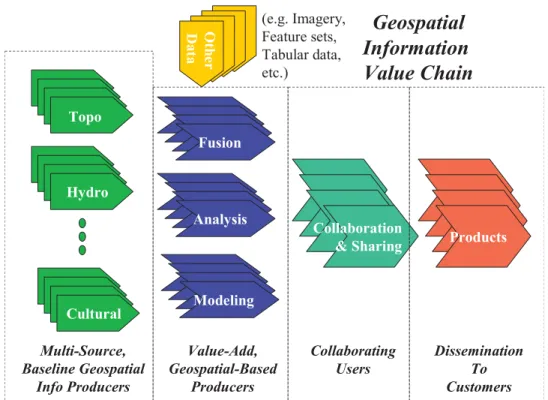
Geospatial: A Fundamental Information Ingredient
Geospatial Information Value Chain
Requirements on OGC Technologies
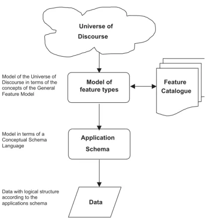
The information aspect defines conceptual schemas for geospatial information and methods for defining application schemas. Conceptual or underlying schemas are formal descriptions of a model of any geospatial information.
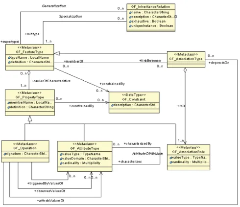
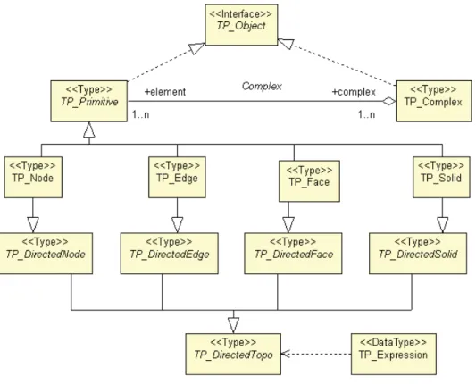
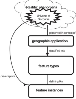
Geographic features
They consist of one or more attributes (properties) with name, type, value and [optional description]. More about attributes below.) The semantics of an attribute requires that it be uniquely identified by its name. It contains a set of values, each associated with one of the elements in a regular set of points or cells.
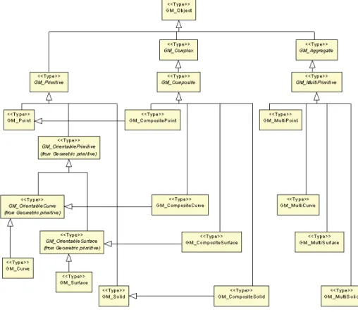
Spatial-temporal geometry and topology
Indeed, many components of the landscape can alternatively be viewed as discrete or continuous. Any object that inherits the semantics of GM_Object acts as a set of direct positions.
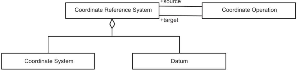
Spatial Referencing
Types of coordinate reference systems include: geocentric, geographic (including an ellipsoid), projected, technical, image, vertical, temporal. BASELINE The conceptual scheme for coordinate reference systems has been adopted as OpenGIS Abstract Specification, Topic 2: Spatial Referencing by Coordinates (version OGC 01-063r1).
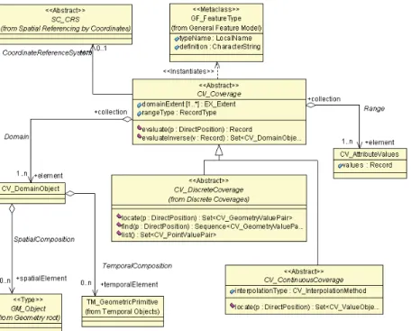
Coverages including imagery
Based on their spatial properties, grid data can be classified into two subclasses, georectified and non-georrectified grid data. Based on attribute properties, grid data can be classified into two subclasses: image and thematic.
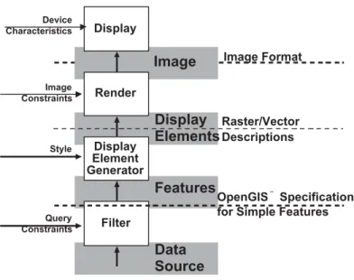
Portrayal and human interface
The sensor description provides important metadata to support the interpretation of the result. The name of the sample phenomenon or observable provides an important classifier for a measurement.
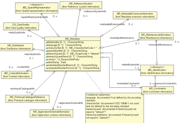
Metadata
A subset of elements, known as core metadata elements, necessary to identify a set of data commonly used for cataloging purposes is defined. In June 2001, a proposal to include material in addition to the ISO 19115 standard was accepted as document "01-111 Metadata AS". FGDC, in conjunction with ANSI INCITS L1, plans to migrate the FGDC content standard for geospatial metadata to the ISO 19115 profile.
Information communities
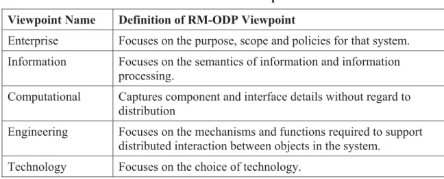
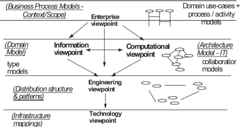
The importance of the metamodel lies in its specification of a common model for understanding, sharing, and reusing the content of registry implementations. A feature catalog contains definitions and descriptions of feature types, feature attributes, and feature associations that appear in one or more geographic data sets, along with any feature operations that may be applied. The computational point of view is concerned with the functional decomposition of a system into a set of services that interact with each other at interfaces.
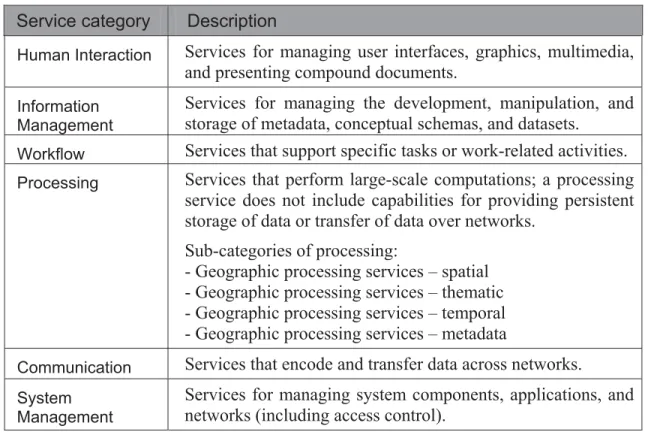
The ORM Computational Viewpoint also includes service classification examples and a description of the OGC service framework.
Services, Interfaces and Operations
For an NSDI theme, the conceptual schema will specify, as appropriate, the feature types, attribute types, attribute domain, feature relationships, spatial representation, data organization, and metadata that define the information content of a dataset. A Framework data content standard includes a format-independent specification of a conceptual model that can be implemented with one or more logical and physical models. An instance of a service can be associated with a specific instance of a dataset, or it can be a service that can be used to operate on multiple, unspecified datasets.
Service operations can be associated with data classes (data type) or with instances (data set).
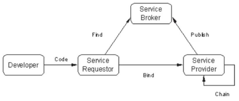
Publish, Find and Bind Pattern
Service Requester: Performs service discovery operations on the service broker to find the service providers it needs and then accesses the service providers to provide the desired service. Service requesters typically use the metadata published to the broker to locate service providers of interest. Binding: Used when a service requester and a service provider negotiate as appropriate so that the requester can access and invoke the provider's services.
A service requester typically uses service metadata provided by the broker to bind to a service provider.
Service Type Examples
Geographical processing services – spatial – Geographical processing services – thematic – Geographical processing services – temporal – Geographical processing services – metadata. Processing services may be tightly or loosely coupled with other services, such as data and portrait services. Processing Services can be sequenced in a "value chain" of services to perform specialized processing to support information production workflows and decision support.
Portraying Services may be tightly or loosely connected to other services such as Data and Processing Services and transform, combine or create ported results.
Applying services
In this case, a third-party coverage rendering service (CPS) is chained to the WCS to convert the data into a client-usable map. The Enterprise, Information, and Computing views describe a system in terms of its goals, content, and functions. The engineering view also provides conditions for assessing the "transparency" of a system of networked components—that is, how well each part works without detailed knowledge of the computing infrastructure.
The technical point of view can be described in terms of UML collaboration diagrams and implementation diagrams.4.
Multi-tier architectures
Application services' is used in the engineering view as an aggregation of services on user terminals. Providing access to geospatial data (eg geographic features and images) and other geospatial application services and data services; Interaction with client-side application services via the appropriate network protocol depending on the platform used.
The above discussion of client- and server-side application services notwithstanding, the OPS services framework does not distinguish the myriad options for deploying applications on a network.

Bridging multiple networks
OpenGIS Application Services implementations are, through standardized interfaces and coding, able to freely mix and match OpenGIS Services Framework capabilities in physical implementations to meet specific market or application requirements. BASIS The engineering perspective for OLS, including defining the components that provide access to services across multiple networks, is under development in the OGC Interoperability Program. A Sensor Collection Service (SCS) server11 collects readings from on-site environmental sensors via a private network (cellular, microwave, etc.) and provides summaries or interpretations of those readings to SCS clients on the web, as described below.
BASELINE The technical position for SWE, including the definition of components that provide access to sensors on other networks, is being developed in the OGC Interoperability Program.
Distribution transparencies
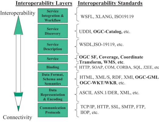
This section provides an overview of OGC's approach to implementing multiple DCPs, followed by a list of current encodings used in OGC, including XML, images, and the well-known binary and text encodings. The technology aspect also summarizes the technologies chosen for the implementation of web services and the OLS platform.
Multi-platform Implementation Approach
Implementation View of the OpenGIS Information Framework
Observation model – The general model for presenting observations of earth phenomena; general observational model for describing known observations. Sensor model – General model for sensor phenomena; general sensor model for describing known sensors. Directory Model - The general model for representing popular types of Internet directories (eg the Yellow Pages).
Gazetteer Model – The general model for representing online, well-known types of gazetteers (eg NIMA Gazetteer).
OGC Encodings; including GML
Sensor Model Language – the language for describing and coding sensors (in situ, satellite and airborne). XML for Images and Map Annotations (XIMA) – the means to encode annotations on images, maps and other geospatial data. Web Services Description Language – the language for describing and coding services; primarily used to fill Service Registries (Publishing Services), service discovery (Discovery Services) and service access.
The definitions of the known text representations are modeled after the POSC/EPSG coordinate data model.
Web Services Platform
Further knowledge of the content is required to "bind" to the service with a meaningful query. The basic function of the Sensor Collection Service (SCS) is to provide a web-enabled interface to a sensor, collection of sensors or sensor proxy. The Geocoding Service interface allows for a request that provides an address or set of addresses and returns it along with the corresponding geometry (usually a point relative to a requested spatial reference system.) The request is "sent" to a Geocoding Service, which the request and returns the resulting geographic feature representing position.
A geoparsing interface that implements this specification operates in the context of two bodies of information: a reserved vocabulary (usually of place names) and a text source (e.g. a newspaper or voting track.) The Geoparser service returns all instances of the use back (in the text source) any word in the reserved vocabulary.
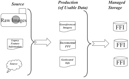
Information Producer Scenario
The second step ends when all the observed instances of FFI features in the area of interest have been captured and are ready to be included in a new or updated FFI product. The information standpoint of the production scenario is best understood by building a service model for each of the fundamental services in the scenario. Particularly important for GIS are information types in support of the OGC feature model, image model and coverage model.
One way to distinguish between "control" and "resource" is that "control" usually persists and can be used in following operations, while "resources" (such as manual labor time or hourly use of a scarce device) are consumed during the operation and must be replenished .
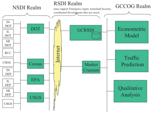
Information Broker Scenario
The intent is to increase the development of light industrial, retail and single-family homes in areas of the region that need them. To evaluate the proposals, GCCOG adopted an econometric model and a traffic forecasting model. Each member of the GCCOG will use visualization and display tools and searches to compare the results of different alternatives.
Similarly, GCCOG will use environmental parameter data and environmental models to determine development impacts.
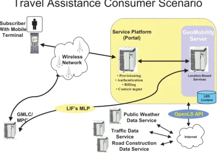
Information Consumer Scenario
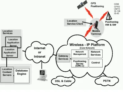
A consumer travels to a dental appointment and the wireless service provider offers travel assistance through a personal navigation service. The scenario involves a wireless service provider offering location-based services including routing and display, route guidance (maneuvers and announcements), traffic reporting and weather reporting. The subscriber seeks travel advice from the provider via a personal navigation service accessible via their mobile phone.
The customer receives visual and audio guidance for negotiating the optimal route to the dental office.
OpenGIS Abstract Specifications
OpenGIS Implementation Specifications
OpenGIS Discussion Papers
ISO TC211 References
Other References
Subsetting Service None, but can be built using WFS, GML, and Filter Analysis Sampling Service None, but can be built using WFS, GML, and Filter Analysis Tiling Change Service None Dimension Measurement Service None Analysis. OGC Reference Model Topic 12 Sub-requirement OGC-SPECS Function Manipulation None Analysis Function Matching None Analysis Function Generalization None Analysis Routing OpenLS Routing Service Analysis Positioning Service OpenLS Gateway Service Analysis Proximity Service OpenLS Directory Service Analysis atic Geoparameter Calculation None Analysis atic Thematic Classification None currently, but could be built based on of the possibilities in WFS and WCS. Analysis atic Function Generalization None Analysis atic Sub-setting service WFS, Filter, OpenLS Directory Service Analysis atic Spatial count None currently, but can be based on WFS, Filter and GML Analysis atic Change detection None.
None Analysis atic Image Processing Image Processing, SensorML, Sensor Collection Service, Sensor Planning Service Analysis atic Lower resolution generation Image Processing Analysis © OGC 2003– All rights reserved.