This report covers the results of the 2018 monitoring activities undertaken as part of the implementation of Renard Mine's Environmental and Social Management System (ESMS). This report presents the results of 2018 monitoring activities associated with the implementation of the environmental and social management system at the Renard mine.
TSM Program
Protocols
As an ESMS was in place during construction, the mine was built without any notices of non-compliance or violations. SWY also acquired environmental management software to implement an ESMS in accordance with the ISO 14001 standard, the applicable regulatory framework and the environmental objectives set by SWY.
Overview of TSM Performance
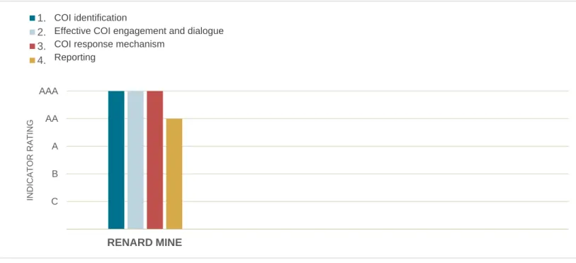
In addition to its excellent occupational health and safety performance, the Renard mine achieved a level AA rating for three of the five indicators in the protocol and a level AAA rating for the two most important indicators (Figure 2.4). A tailings management system is in place covering each stage of the tailings impoundment life cycle (planning, design, construction, operation, closure and decommissioning).
Environmental Surveillance Program
Ecopermitting Procedure
Regular reviews of the tailings management system along with its performance are conducted quarterly and annually. An external half-yearly audit with a review of the effectiveness of tailings management to be presented to senior management is underway.
Recyclable, Ultimate and Hazardous Materials Management
Hazardous Materials Management
Recycled and Ultimate Solid Waste Management
The amount and types of solid waste deposited at the TLS, the materials used to cover the waste materials, and the final cover materials are all recorded. Biomedical waste (BMW) generated at the Renard mine site is recovered in the infirmary.
Contaminated Soil Management
An environmental monitoring program is required under Condition 4.1 of the Global Certificate of Authorization (CA) and Comprehensive Study Report (CSR) issued by the Canadian Environmental Assessment Agency (CEAA, 2013). The environmental and social monitoring program is part of the environmental and social management framework based on the ISO standard.
Weather and Climate
- Temperature
- Precipitation
- Snow and Ice Cover
- Wind
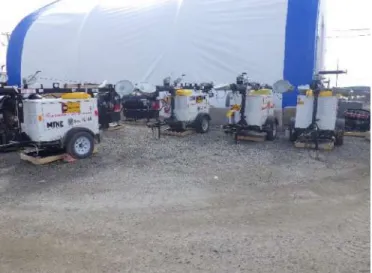
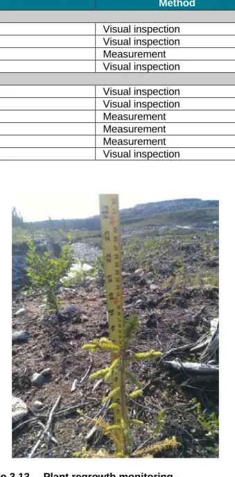
Across the province, the trends observed at the Renard mine site were consistent with those observed in Quebec in March, throughout the summer and fall through December 2018. Snow cover was also measured at the mine site and used in calculations of the water balance (photo 3.3).

Air Quality and Atmospheric Emissions
Air Scrubber Management
Air Quality Monitoring
Metal concentrations that were measured (24-hour concentrations) or calculated (annual average concentrations) at the property boundaries were all in compliance with the applicable daily and annual CAR standards. The results were all in compliance with the applicable CAR standards, including the more restrictive hexavalent chromium standard.
Atmospheric Emissions and Greenhouse Gases (GHG)
Since GHG emissions from stationary equipment exceeded 25,000 mt (CO2 eq.), an external audit report was drawn up. As greenhouse gas emissions from fixed equipment exceeded 25,000 mt (CO2 eq.) in 2018, an external emission audit report was produced.
Noise and Vibration Levels
Noise Levels
In 2017, measured and verified GHG emissions from fixed equipment at the Renard mine amounted to 39,268 mt (CO2 eq.). More specifically, GHG emissions from stationary equipment reached 44,464 mt (CO2 eq), while GHG emissions from mobile equipment were 21,336 mt (CO2 eq).
Vibration Levels
Daytime noise levels were generally lower or slightly higher than the 55dBA standard including the +5 dBA penalty. As in 2017, noise levels were investigated when the mine was in normal operation, as well as when the crusher was not in operation.
Hydrological Regime
- Water Levels and Water Level Stations
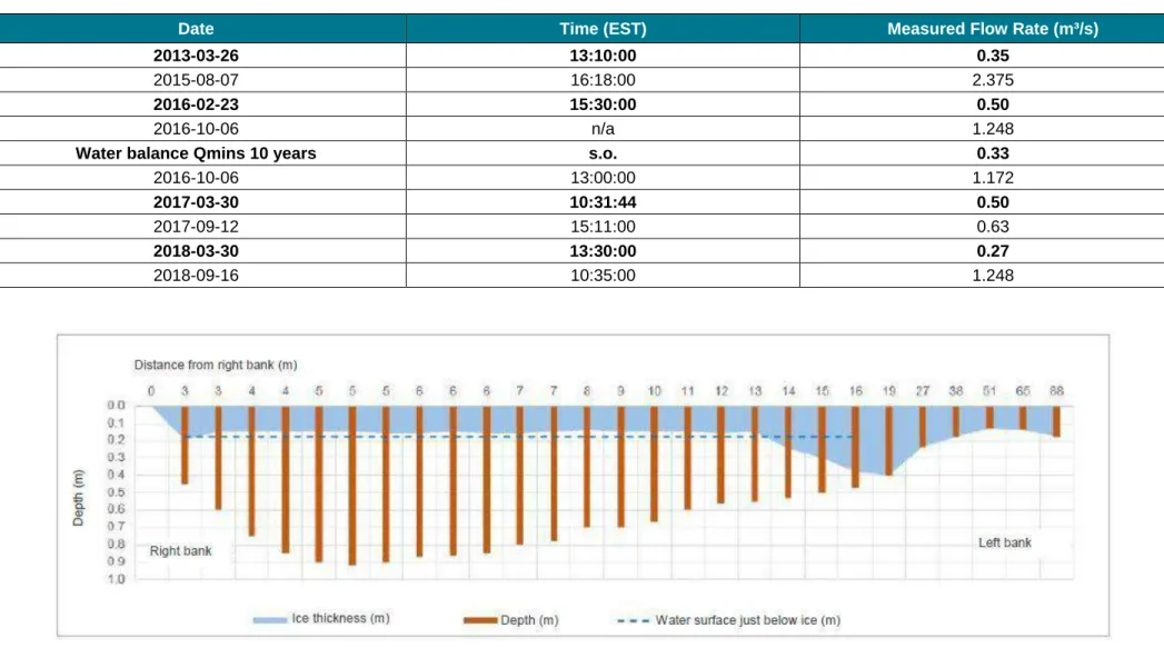
- Winter Flow Monitoring at A-A’ and B-B’ Riffles
- Flow Monitoring during Low Flow Period – Lake Lagopede
- Lake Lagopede Water Balance
The various modeling studies of mine effluent dispersal revealed a seasonal limitation to flow at a shoal between the north and south basins of Lake Lagopede (A-A' and B-B' riffles) (Map 3.3), particularly during the low-flow winter period. . Further studies are also needed to validate and confirm the movement of mine wastewater in the southern basin of Lake Lagopede. Freshwater withdrawn by the SWY represents less than 1% of the total outflow from the northern basin of Lake Lagopede.
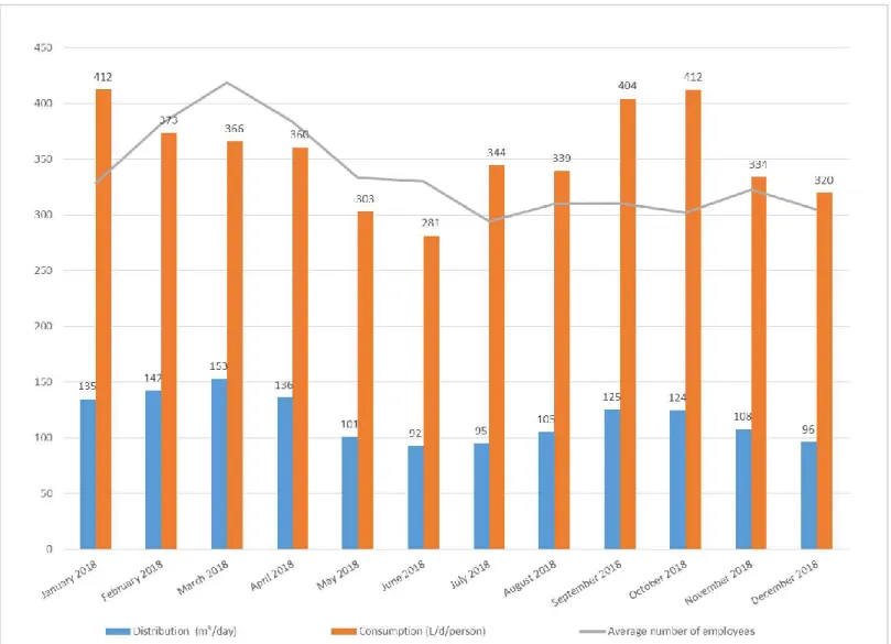
Drinking Water Quality
Drinking Water Consumption
Drinking Water Quality Monitoring
In 2018, the concentration of residual chlorine was always maintained above the required limit of 0.3 mg/l at the outlet of the device, which ensured optimal disinfection. The membranes in the two nanofiltration units are washed monthly to maintain the physical integrity of the filtration system and its lifetime. 51 Table 3.7 Analyzes of drinking water quality according to Annex 1 of the RQEP of drinking water quality.
Surface Water and Sediment Quality
- Objectives
- Sampling Area and Period
- Surface Water Quality
- Sediment Quality
- Monthly Temperature and Conductivity Monitoring at the Mine Effluent Outfall Site
- Conclusion
The main characteristics of surface water quality measured in 2018 are presented in the following sections. Mercury is part of the natural geochemical background in streams and lakes in the study area. The trophic level in lakes and streams is comparable to the level found in the 2010 baseline.

Vegetation and Wetlands
- Application of Vegetation Mitigation, Compensation and Restoration Measures
- Plantation Performance by Restored Area
- Wetlands Compensation Program
- Wetland Monitoring (Route 167N)
In the first four-month field season (2018), two teams of UQAT students were on-site in June and August to visit 48 ponds, evenly distributed among different types of ponds (beaver ponds and peat ponds), arranged along a north- south. The data collected includes numerous sightings of vertebrates in various ponds, which have proven promising. The second study aims to analyze and model the dynamics of typical lichen and plant communities in northwestern Quebec wetlands.
Fish and Benthic Communities (EEM)
- Study Area
- Fish Study
- Analysis of Potential Use of Fish
- Benthic Invertebrate Community Study
- Supporting Environmental Variables
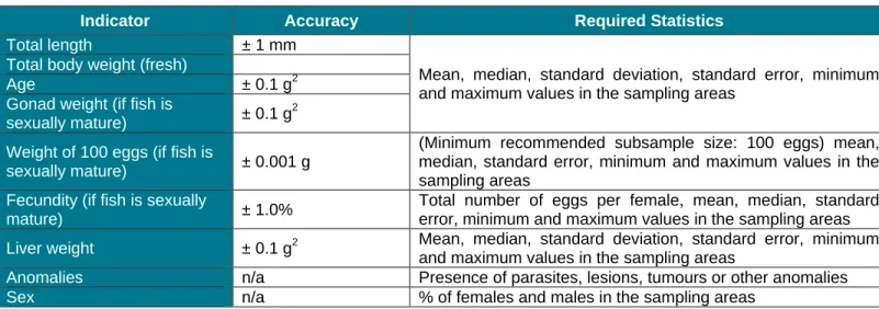
- Interpretation Report
Gonadal weight (if fish are .. Minimum recommended subsample size: 100 eggs) mean, median, standard error, minimum and maximum values in the sampling areas. The benthic community survey will be carried out at the same time as the fish community survey in autumn 2019. Biological diversity peaks in autumn, and the organisms' level of development facilitates identification.
Fish Habitat
- Maintaining Fish Habitat Conditions in Lake F3298
- Maintaining Free Movement of Fish in the Outlets to Lakes F3300, F2607 and F3301
- Maintaining Appropriate Hydraulic Conditions for Brook Trout Spawning and Egg Incubation in the
- Diversion Channel – Lake F3298 Outlet
Since the water level was particularly high at the time of the research in 2018, brown trout were able to move freely in this stream. In the 2018 monitoring, the water level at each of the alleged obstacles in 2016 was very high. The second survey of the state of natural spawning grounds in the tributary of lake F3301 was carried out in September 2018 (map 3.6).
Fish Habitat Compensation
- Monitoring the Integrity and Use of Brook Trout Habitats at the Mine Site
- Monitoring Lake Trout Spawning Ground in Lake Lagopede
- Development of Walleye Spawning Ground near Mistissini
- Development of Brook Trout Habitat in Lake Mistassini Sector
- Baseline for the Diversion Canal on the Former Icon-Sullivan Mine Site
The integrity of the spawning ground was monitored one year after the development work, in 2017. The next monitoring report on the integrity and use of the lake trout spawning ground is planned for winter 2020. Development of a 600 m² zander spawning ground in Lake Mistassini is the third component of FHCP required under authorization no.
Segments C and D on the Extension to Route 167 (Mine Road)
Monitoring Free Passage of Fish at Stream Crossings
Mistissini, where Lake Mistassini narrows between Baie du Poste and the main body of the lake further north. Development of brook trout habitat in a tributary of Lake Mistassini is the fourth component of the fish habitat compensation program. Development of the diversion channel at the Icon-Sullivan site (Waconichi River) is the last of five components of the Renard Project Fish Habitat Compensation Program.
Monitoring of Fish Habitat Compensation Measures
End of Monitoring
Terrestrial Animals and Birds
Big Game Monitoring
To record wildlife sightings along Route 167, the gatehouse security guards systematically ask truck drivers if they have seen any wildlife along Route 167. Bears are most commonly seen along the road, and only one caribou (but no moose) was seen along Route 167. North. In addition to keeping road users safe, these measures have reduced road accidents involving large game animals.
Bird Monitoring
A bulletin was posted in common areas (ie, the cafeteria) and the topic was discussed at coordination meetings. The first aimed to check the nest boxes and record whether they had been used (signs of presence and identification of the species involved). Although the nest boxes were intended for the Barrow's Goldeneye, they could well be used by other species, such as barn owls, owls or squirrels.
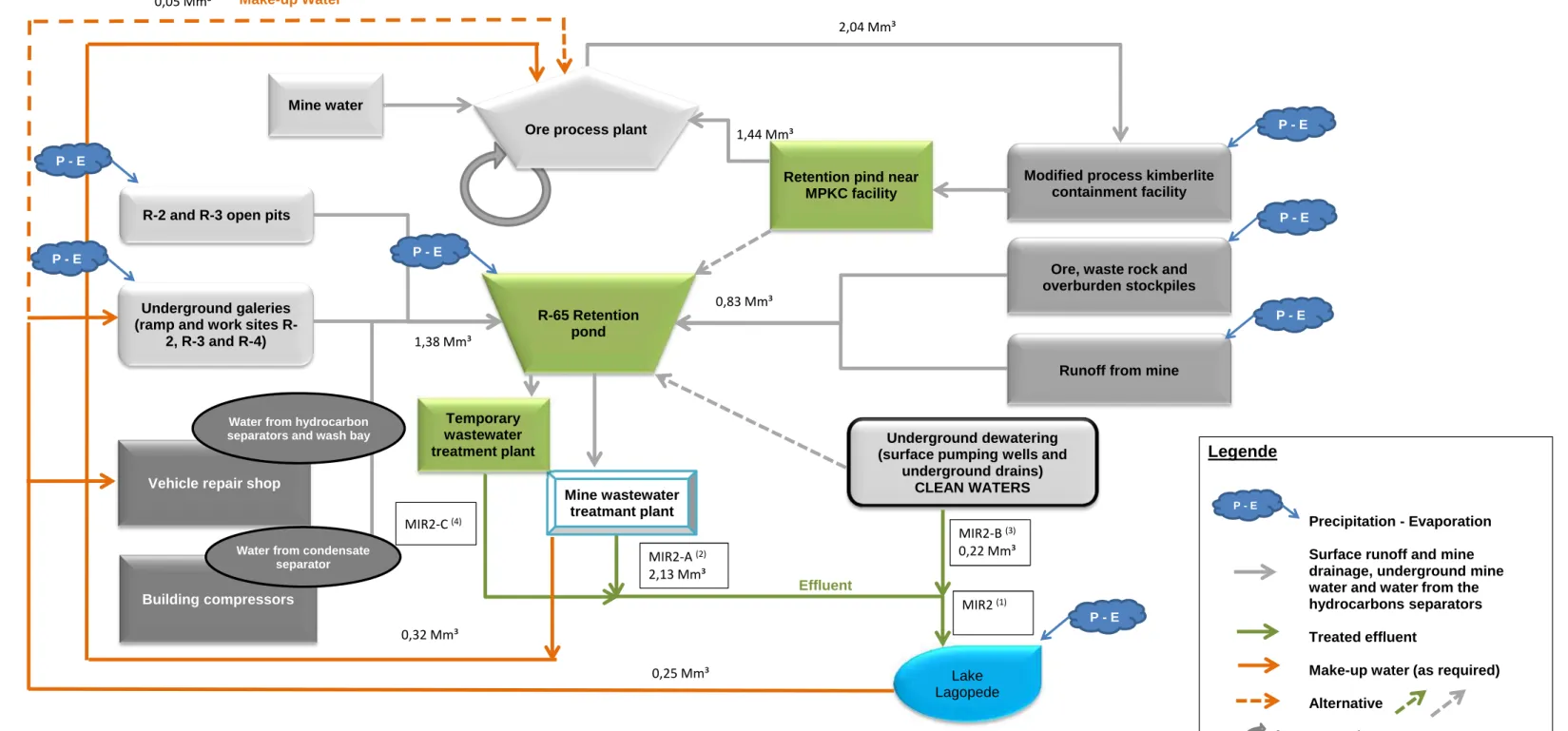
Water and Effluent Management
- Dewatering Water
- Mine Effluent Quality
- Contingency Treatment Plant
- Water Withdrawal
- Water Re-Use
- Domestic Wastewater
- Hydrocarbon Separators
The difference between the final volume of mine effluent and the volume of water collected in the bypass canal system was reused to supply the ore processing plant (323,820 m3) and as a dust control agent in the mine roads (8,256 m3). Confirmation of this would make it feasible to collect and use the dewatered sludge in the gradual restoration of the mine area. Quarterly monitoring is also undertaken to ensure effluent quality in separators.
Hydrological Regime and Groundwater Quality
The higher of the resuscitation criteria and the background level was used to compare the results in Tables 3.14 to 3.18 with the benchmarks. Specifically, in Sector 1, zinc and copper concentrations showed several values that exceeded background levels (Table 3.14). In Sector 4 (TLS), the quality of groundwater samples collected since 2015 has remained very stable (Table 3.17).
Containment Facility Surveillance
At the beginning of the year, management set itself the goal of achieving at least level A for each indicator in the six protocols. From the beginning, the environmental monitoring program's observations have been documented in a computerized program. If the quality of the restoration is insufficient, corrective measures will be taken if necessary.
Scope of Social Monitoring
Recruiting, Job Types and Numbers
Scope
Validate the employment targets achieved among the Cree in construction (short term) and operations (long term) as agreed by the Renard Committee under the Mecheshoo Agreement;. Document the effectiveness of recruitment and training measures implemented by the company and its Cree partners. According to the Mecheshoo Agreement, relevant documents are submitted and presented to the Renard Project Education and Employment Committee as well as the Renard Liaison Committee formed under the Partnership Declaration signed with Chibougamau and Chapais.
Recruiting and Information Sessions
During the construction, operation and closure phases, document the type (job category) and changes in jobs created by the Renard project for the residents of Chibougamau and Chapais on the one hand, and for all residents of James Bay on the other. Document the participation of Crees, and more specifically the members of the M11 trapline family, in the various environmental monitoring activities; Identify the determinants of the results achieved (successes and failures) and any corrective actions taken.
Recruiting Details
This growth allows people from different cultures and experiences to work towards a common goal and contribute to the success of the Renard mine. Note that 50% of the promotions and transfers involved 34% of the workforce, which is the portion represented by Cree employees (13%) and workers from Chibougamau and Chapais (21%). The promotions and transfers of our Cree and James Bay personnel to underground operations are testament to the success of the apprenticeships offered to our workers.

Agreements
Provisions of the Mecheshoo Agreement and the Partnership Declaration
Monitoring Committee Achievements
Efforts made to influence the establishment of mining industry training within the Cree School Board and the Minopro Group, thereby promoting mining jobs within Cree communities;
Committees for Implementing and Monitoring Agreements
Cree Worker Integration
Scope of Monitoring
The aim of the fund is to create a qualified workforce that meets the expectations of Stornoway and the mining sector. Stornoway and Cree members of the Training and Employment Committee established the Cree Workforce Inclusion Plan in 2014. The committee's collaborative spirit led to the creation and implementation of the Cree Workforce Inclusion Plan.

Raising Awareness of Mining-related Jobs
Land Use by M11 Trapline Users
Scope of Monitoring
Collect information on user perceptions of impacts, along with their concerns and comments regarding the project and mining activities. The results of land use monitoring by M11 trap users will be presented to these trap users at swallow member meetings. The purpose of the meetings and calls was to keep members of the Swallow family informed of the progress of work and operations at the Renard mine and to address their questions and concerns.
Land Access
Record users' assessment of the various mitigation and improvement measures implemented by Stornoway to enable them to practice their traditional activities;. In addition to the 1km no-hunting zone around the mine and airport sites, members of the Swallow family can practice their traditional activities throughout the land, including along the road between the mine and the airport. To raise awareness among stakeholders, Stornoway in turn published notices about the safe use of the mine road in the media.
Comments, Perception of Impacts and Project-related Concerns
143 km) and Stornoway (97 km) has become a public road that everyone can use up to the mine gate house, the border of the area which is strictly controlled for security reasons. A joint committee for Route 167 was established by MTQ in 2014, a collaborative effort that has made the highway safer and boosted emergency response on the road. In the event of an incident, Stornoway immediately contacts local authorities to inform them of the situation so they can relay the information to residents via radio broadcasts and social media.
Local and Regional Economic Benefits
Scope of Monitoring
Goods and Services Contracts
In line with its sustainable development approach, Stornoway awards goods and service contracts to competitive local businesses. Splitting the contracts and negotiating specific contracts directly with the supplier proved to be very beneficial to both local businesses and the Renard mine. Indeed, Stornoway is very proud to have relied heavily on its business partners for the development and operation of the Renard mine, which in turn had a positive impact on the growth of the host communities.
Projects funded by the Mistissini / Renard Business Development Fund
Communications
Possibilités d'emploi et événements/activités communautaires à venir diffusés par une station de radio locale à Mistisini ;. Code de recommandations techniques pour la protection de l'environnement des systèmes de stockage et de manipulation des dérivés pétroliers et produits connexes (PN 1327). Modélisation des rejets d’eaux usées minières après captage et pompage des eaux souterraines.
Air emission, air quality and noise monitoring stations
Location of seismographs
Location of water level stations, A-A’ and B-B’ riffles and measuring points – Summer 2018
Surface water and sediment quality monitoring station
Revegetated area on the mine site
Fish and fish habitat monitoring stations
Water from Lake F3298 outlet diverted to Lake F3295 by way of stream R170
Sampling stations at lake trout spawning ground in Lake Lagopede
Location of nesting boxes on the periphery of the mine site
General water management and collection system
Groundwater level and quality monitoring stations – mine area
Groundwater level and quality monitoring stations – TLS and airstrip area
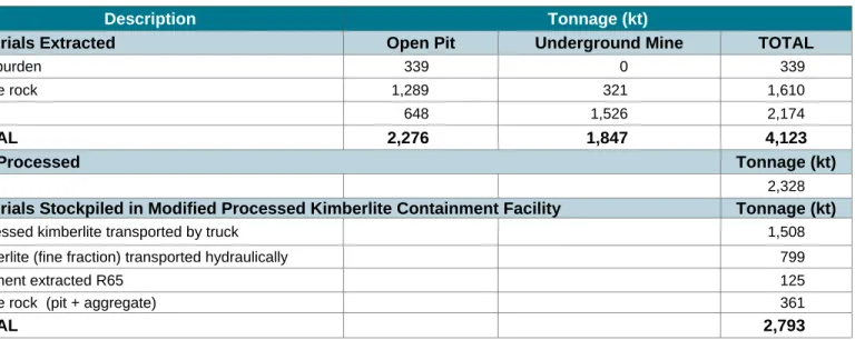
Containment facilities at the Renard mine