Jimmy MacLeod Honorary Chairman, Cree Community Relations. Larry MacLeod President, Cree and Jamesian Community Relations.
Introduction
Objectives of the study
Develop a monitoring program that aims to verify the extent of identified impacts, verify the effectiveness of mitigation measures, and confirm and/or specify certain impacts. They are taken into account both in the impact analysis and in the development of mitigation measures.
Study contents
Context and justification
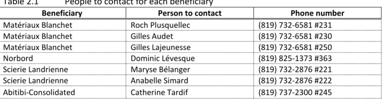
- Project initiator and his consultant
- Presentation of the initiator
- Presentation of the consultant
- Context and justification
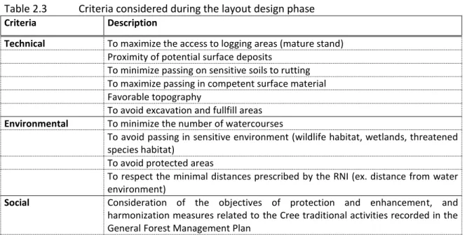
- Analysis of the alternatives
- Alternatives
- Access strategy to the territory – Type of forest road
- Determination of the layout
- Other projects related to the studied roads
Considering the lack of an access network in the northern sector of FMU 86-65, the construction of a forest road to access logging areas. For these reasons, there is no alternative presented for the construction of an access road.
Description of the adopted project
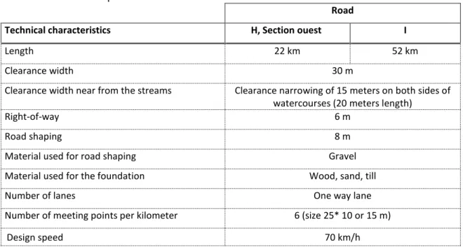
- Technical characteristics
- Borrow pits
- Watercourses crossing
- Workers
- Safety standards and emergency plan
- Traffic
- Calendar and works cost
Wood waste and non-commercial wood will be integrated into the subgrade (roadform) of the road. It is expected that the construction of two parts of the forest road will be done simultaneously.
Description of the environment
Delimitation of the study area
Physical environment
- Climate
- Physiography and deposits
- Rocky substrate
- Ecological framework of the territory
- Hydrographical network
- Other territory features
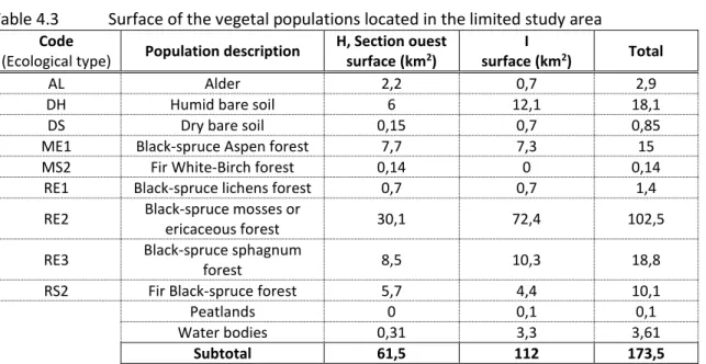
RE2 2 Black spruce bog or ericaceous forest on thin to thick deposit, with medium texture and mesic drainage. RE2 5 Black spruce bog or ericaceous forest on thin to thick deposit, with medium texture and subhydric drainage.

Biological environment
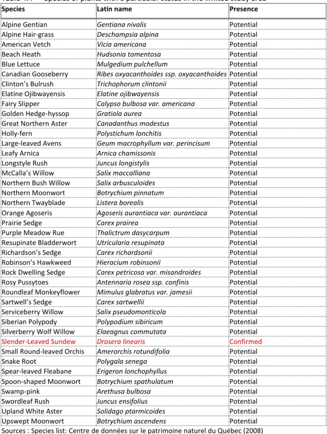
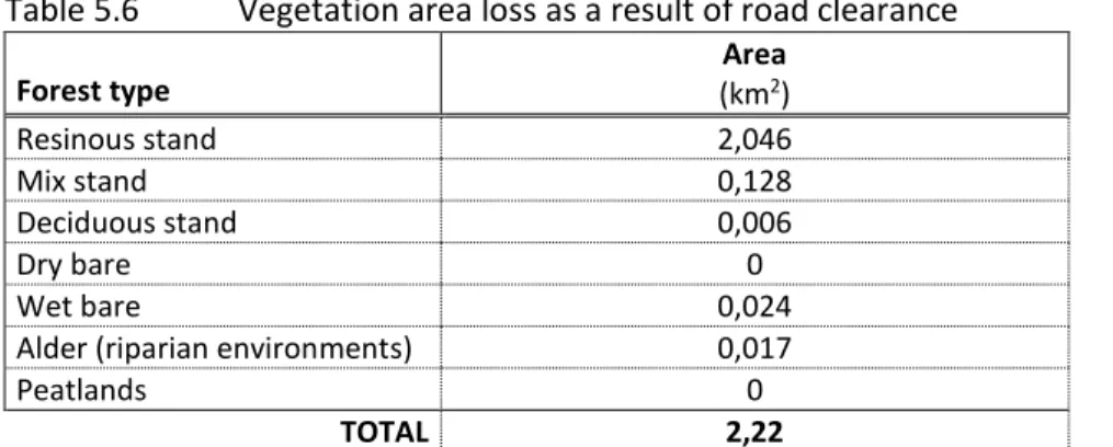
- Vegetation
- Wetlands and riparian environments
- Aquatic fauna
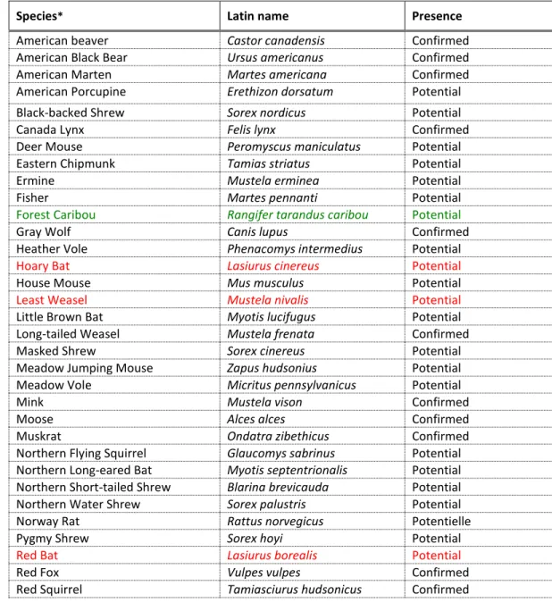
- Terrestrial fauna
- Avian fauna
- Protected wildlife habitats
There are no plant species of traditional use with a special status in the study area. The limited study area is part of the distribution zone for semi-forested peat bog.
Social environment
- Socio-economic context of the Nord-du-Québec
- Territorial division
- Territory uses by the native communities
- Current and envisaged uses by the other users
- Protected areas
- Other activities in the sector
- Archaeological and cultural potential
- Concerns raised during the consultations
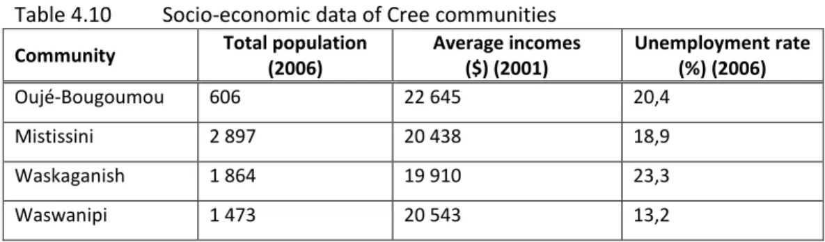
The general trend for the territory of Eeyou Istchee from 2001 to 2006 is an increase in population. Average individual income is also slightly lower than the provincial average. There are certain privileges regarding the hunting rights of local communities and for participation in the administration and development of the territory.
The opening of the territory could thus contribute to greater visits by other users. On the other hand, the Asiniški Park project is on the northern border of the study area (see plan B/D-0933). According to the GESTIM MRNF register, there is no active mining lease in the area in question.
He also agreed to contribute to the planning of the other consultations with the other Cree interveners. Alongside the consultations with the Crees, the representatives of Baie-James municipality were also consulted.
Environmental impact assessment
Impacts identification method
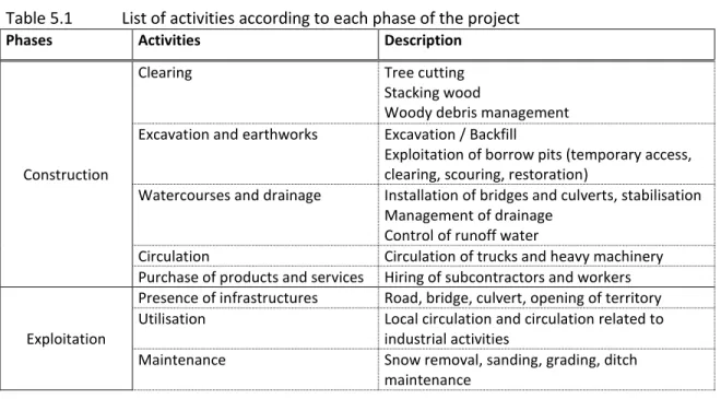
- Identification of the activities connected to the project
- Identification of the environment components
- Potential interactions
The next stage in the assessment process is the exposure of sensitive components of the environment, i.e. This depends, as already mentioned, on the intrinsic properties of the component, determined by expert judgement. It also derives from the social value assigned to the component and determined by legislation and the interests or concerns of the intervenors.
The environmental value assigned to the environmental components was checked on the basis of the public consultation carried out in the context of the current project and also during development by the MRNF and the beneficiaries of the 2008-2013 GFMP. Communications with Ministry stakeholders and consultation of legislative documents supplemented the sources of information used to assign an environmental value to the components. If the component is relatively abundant or if it has been assigned a particular interest or service, its value was considered average.
The following table shows a preliminary portrait of the impacts that the project activities could cause on the components of the environment. Land Uses by Crees Other Land Uses Archaeological Potential Regional Economy.
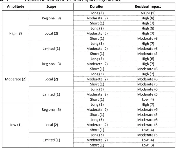
Evaluation method of the importance of the impacts
- Amplitude
- Duration
- Scope
- Evaluation grid
The duration represents an estimate of the time over which the project activities will be felt. Short duration: results from an activity where the disturbance is felt in a certain period of time, either during the construction phase of the project (e.g. culvert installation). Long duration: results from an activity where the disturbance is felt permanently, either for the entire duration of the use of the access roads (e.g. the presence of a road, a bridge, a culvert).
Scope represents the area of the territory as well as the number of individuals or elements affected by the project activities. It may happen that the scope is felt outside the wider field of study, for example as the scope of activities of the socio-economic environment. An impact analysis based on the evaluation criteria described above will make it possible to determine the significance of the residual impact.
The analysis is carried out by a method based on the quotation of evaluation criteria (numbers in brackets). The plan in its original format is presented at the end of the document (plan D-0934).
Impacts during the construction phase
- Biophysics environment
- Human environment
Mitigation measures: During the studies that will be done before the construction of the road, some corrective measures can be applied in the layout if special plant species with status are observed. Special attention will be paid to the identification of nesting sites during surveys. Operating techniques adapted to the geomorphological context of the area will have to be applied.
Regular and appropriate maintenance of machinery will need to be carried out to reduce the risk of spillage. Thus, the amplitude of the impact is considered to be moderate, even if no spawning grounds were confirmed in the limited study area. Since the soils that are likely to be affected are limited to those that are localized on the section of both routes during construction activities, the impacts will be specific and short-lived.
Presence of other users during the construction phase will be limited to the employees and the subcontractors of the beneficiaries. Residual impact: It is difficult to evaluate the impact that the activities of the project may have on the archaeological potential.
Impacts during the exploitation phase
- Biophysics environment
- Human environment
Residual Impact: Once operational, the amplitude of the impacts is considered to be low. The impacts will be prolonged throughout the period of utilization of the forest roads, and the extent will be local. Maintenance of the road in the vicinity of bridges and culverts is likely to generate sediment contributions to the rivers.
Residual impact: The maintenance of the ways by the beneficiaries can cause impacts of low amplitude and specific magnitude on rivers. Duration is moderate as the risks continue throughout the exploitation phase of the ways. With the presence of the road, the tallymen and their family will have an easy and safe access to their trap.
During the exploitation phase of the road, employment will mainly be linked to the maintenance which will only require one or two workers. Residual impact: The amplitude of this positive impact is considered moderate as the access roads will hardly support the use of the current and future potential natural resources in this sector.
Impact assessment results
Cumulative impacts assessment
- Spatiotemporal limits
- Cumulative impacts analyze
The spatial boundaries of the cumulative impact analysis correspond to the territory of FMU 86-65 and the adjacent FMU sector of the projected routes (FMU 86-64 and 86-66). At the temporal level, the selected period begins at the time of the Nottaway-Broadback-Rupert hydroelectric project studies in 1971. This is justified by the fact that most of the reliable data available for this sector comes from these studies.
The cumulative effects evaluation on the use of the area by the Crees, other users and on the regional economy therefore spans a little less than 50 years. A sufficient coordination of the access strategies on the territory will therefore be primordial to ensure. Additionally, some Cree interventionists lamented the abandonment of the program that allowed the natives to participate in the monitoring of the territory and to report the illegal acts (eg, illegal occupation of the territory).
The kiosk at km 6 of the Baie-James road would be an interesting gateway to carry out basic sensitization once individuals entering the territory are registered. Also, the existence of old winter mining roads and the presence of active mining claims in the territory could provide an idea of the future development of the mining industry.
Surveillance and environmental monitoring program
Surveillance program
Le respect du Règlement relatif aux normes d'empiétement sur les forêts domaniales (RNI), notamment dans la construction des ouvrages de franchissement des cours d'eau ; le respect des plans de réintroduction des espèces à statut particulier et de la réglementation sur la protection des hérons ; Bonne gestion des déchets et respect du Règlement sur les entrepôts et décharges de sols contaminés et du Règlement sur les matières dangereuses.
The respect of the layout, while paying special attention not to succeed in sensitive environments or specific areas of interest;. This one will also be present to answer the questioning of the contractors if necessary, and to ensure the application of the intended mitigation measures. The beneficiaries also undertook to regularly inform the tallymen about the progress of the works.
Moreover, to make sure that works remain at the comfort of the tallymen and their families, the beneficiaries propose to make occasional visits with those on the construction site. The writing of an inspection report at the end of the construction works will be proposed to document the measures taken to minimize the environmental impacts, the problems encountered and the elements taken to solve these problems.
Monitoring program
- Monitoring of the presence of Forest Caribou
- Watercourses cross-pieces
- Mitigation measures monitoring
- Communication and monitoring of the impacts on the tallymen and their families
Avis concernant les plans exhaustifs révisés d'aménagement forestier pour le territoire de la Baie James. Ministère de l'Emploi et de la Solidarité sociale, Direction régionale du Nord-du-Québec, 28 pages. Ministère des Ressources naturelles et de la Faune, Faune Québec, Direction de l'expertise en matière de faune et d'habitats.
Ministère des Richesses naturelles et de la Faune, Division des ponts et routes forestières. MINISTÈRE DES RESSOURCES NATURELLES ET DE LA FAUNE (MRNF Statistiques de chasse et de piégeage. Explique qu'il a été inspecteur lors de la construction de la route de la Baie James.
Lemoyne mentionne que s'il n'y a pas de retombées, pas de retombées pour la région de la Baie James, il n'a aucune raison d'appuyer le projet. Globalement, les représentants voient que les impacts associés au désenclavement du territoire peuvent être positifs, à condition qu'il y ait des retombées pour la région de la Baie James. Il explique qu'il ne voit aucun inconvénient à la construction de la route et que cela ne semble pas lui poser de problème.
Louis Ottereyes mentionne qu'il souhaite des aires de stationnement pour sa camionnette le long de l'allée.