STATUS IDENTIFIED IN OR IN THE JAMES BAY REGION OR LOCATED NEAR OR POTENTIALLY LOCATED IN THE STUDY AREA. CARIBOU WINTER HABITAT AND DRINKING HABITAT IN PART OF THE AREA OF IMPACT OF PERMANENT NON-MAN PLANNED MINING. SPECIES ACCORDING TO DIFFERENT SURVEYS (WSP, 2017; WSP, 2018G) WITHIN THE STUDY AND VICTIMS RECORDED IN THE ÉPOQ DATA BANK FROM 1981 TO.
POTENTIALLY PRESENT IN THE STUDY AREA REGARDING ITS RESIDENCE, LIFE CYCLE, SEASONAL MOVEMENTS AND TRAVEL CORRIDORS.
6 DESCRIPTION OF THE RECEIVING ENVIRONMENT
GEOGRAPHIC FRAMEWORKS AND PROJECT STUDY AREAS
- GEOGRAPHIC FRAMEWORK
- LOCAL STUDY AREA
- OTHER STUDY AREAS
PHYSICAL ENVIRONMENT
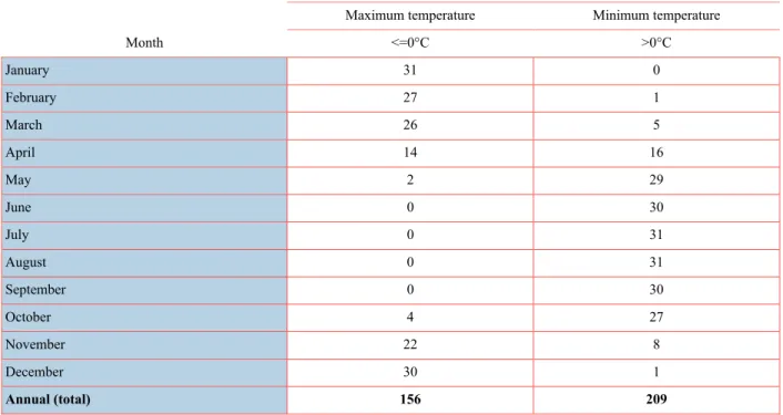
- CLIMATE
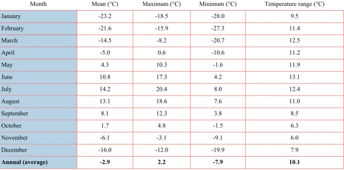
- TEMPERATURE
- PRECIPITATION
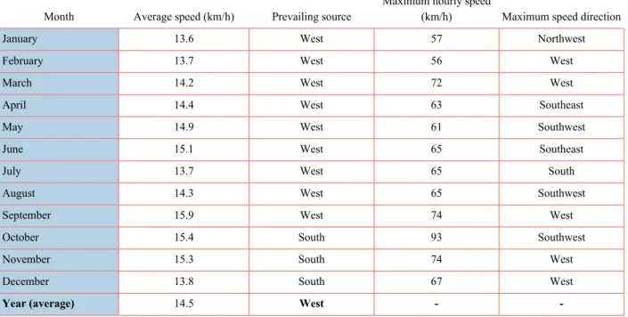
- WIND
- GEOLOGY
- STRUCTURE AND SEISMIC ACTIVITY
- PHYSICAL GEOGRAPHY
- GEOMORPHOLOGY
- HYDROGEOLOGY
- METHODOLOGY
- HYDROSTRATIGRAPHIC UNITS
- GRANULOMETRIC ANALYSIS
- HYDRAULIC PROPERTIES OF MATERIALS
- PIEZOMETRIC LEVELS
- AQUIFER CLASSIFICATION
- AQUIFER VULNERABILITY
- HYDROGRAPHY
- WORK COMPLETED
- WATERSHEDS
- CHARACTERISTIC FLOW RATES AND WATER LEVELS
- BATHYMETRY
- SURFACE WATER AND GROUNDWATER QUALITY
- SURFACE WATER
- GROUNDWATER QUALITY
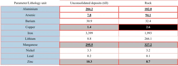
- SOIL AND SEDIMENT QUALITY
- SOIL
- SEDIMENTS
- AIR QUALITY
- AMBIENT NOISE
- ARTIFICIAL LIGHT AT NIGHT
- FIELD READINGS
- RESULTS
The Auclair Formation dominates the surficial geology of the study area (Broad Oak, 2009 in SRK Consulting, 2010). In the northeastern part of the study area, a monogenic to polygenic conglomerate and sandstone indicates that it belongs to the greenstone belt (Broad Oak, 2009 in SRK Consulting, 2010). Also a diabase dyke crosses the central part of the study area on a north-south axis.
In this regard, there is no problem regarding the geological aspects of the soil that are discriminating in the study area. The location of various surveys conducted in the study area is shown on Map 6-5. Note that the drainage system of the area under consideration represents a very small percentage of the Eastmain river basin (a total of 0.1%).
Photos of the watercourses are available in the Hydrological technical study (Étude spécialisée sur l’hydrologie) (WSP, 2018b). This section presents the estimated characteristic flow rates downstream of the six watercourses in the study area. This section presents the main characteristics of the water quality of watercourses in the study area.
Radisson Station was selected from this group as the most representative of the study area.
BIOLOGICAL ENVIRONMENT
- VEGETATION
- METHODOLOGY
- RESULTS
- TERRESTRIAL FAUNA
- LARGE FAUNA
- SMALL WILDLIFE
- SMALL MAMMALS
- AQUATIC COMMUNITY
- ICHTYOFAUNA
- BENTHIC COMMUNITY
- HERPETOFAUNA
- METHODOLOGY
- RESULTS
- AVIFAUNA
- WATERFOWL AND AQUATIC BIRDS
- TERRESTRIAL BREEDING BIRDS
- DATA FROM AVAILABLE DATA BANKS
- SPECIAL STATUS BIRD SPECIES
- BATS
- EXISTING DOCUMENTATION
- ACOUSTIC MONITORING
- SEARCH FOR HIBERNACULA
- SPECIAL STATUS BAT SPECIES
- REVIEW OF SPECIAL STATUS SPECIES
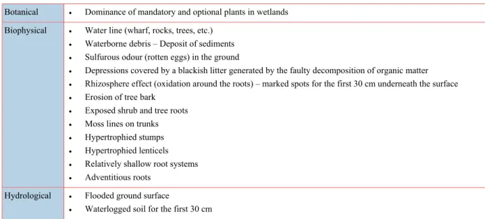
A list of the species that can be expected to be found in the study area was drawn up before starting the field studies. The main factor in forest dynamics in the region is the fire cycle (MFFP, 2017a). Aquatic environments, which include lakes and streams (drainage bottoms and adjacent wetlands that include the coastal area), cover 73.57 ha or 2.0% of the study area.
The species with medicinal uses observed in the field are common both in the study area and this part of the Quebec territory. The project study area is in the central portion of the application area of the Québec woodland caribou recovery strategy (Map 6-14). They were mainly concentrated in the northeastern part of the study area, on the periphery of the Opinaca Reservoir.
Therefore, the analysis of the degree of habitat disturbance seems to be a relevant indicator for the characterization of the current habitat conditions in the study area. The location of the planned mine represents one of the sectors in the area under consideration, which is most burdened by human and natural factors. Scrub and mountains, with or without regeneration, are low-quality environments that dominate the landscape of the study area.
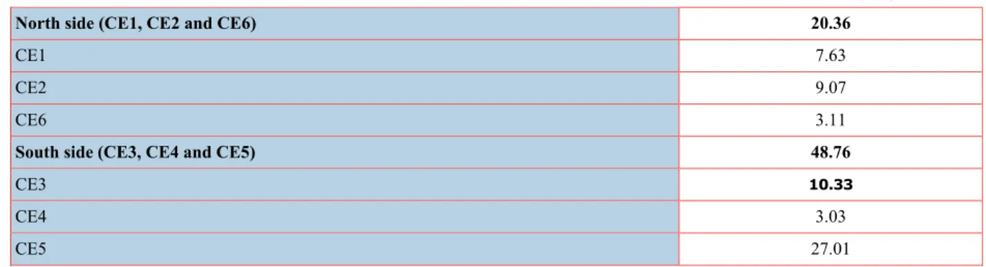
This methodology is based on the use of grill traps set up in typical habitats of the study area. In 2017, seven additional capture sectors were inventoried to complete the initial coverage of the study area. No fish were caught in CE4 creek upstream of the Billy-Diamond Highway (formerly the James Bay Road).
Creek CE5 is a stream flowing from a peat area west of the study area (Map 6-8). Ultimately the river flows into the Eastmain River, more than 10 km downstream of the study area. In 2012, an inventory of terrestrial breeding birds was also carried out in part of the study area.
A revision of this list resulted in the removal of the Canadian warbler because the study area is outside its known range (AONQ, 2019). In forested regions, the rusty patched bird is rarely found deep in the forest.
HUMAN ENVIRONMENT
- STUDY AREA
- OVERALL CONTEXT
- TERRITORY PLANNING AND DEVELOPMENT
- CREE NATION GOVERNMENT AND GRAND COUNCIL OF THE CREES (EEYOU ISTCHEE)
- EEYOU ISTCHEE JAMES BAY REGIONAL GOVERNMENT
- MINISTÈRE DE L’ÉNERGIE ET DES RESSOURCES NATURELLES
- ADMINISTRATION RÉGIONALE BAIE JAMES
- SOCIÉTÉ DE DÉVELOPPEMENT DE LA BAIE-JAMES
- REGIONAL AND LOCAL ECONOMY AND POPULATION
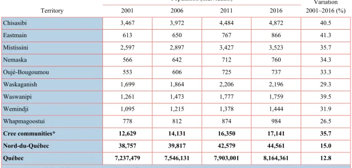
- POPULATION
JAMES BAY LITHIUM MINE ENVIRONMENTAL IMPACT ASSESSMENT – JULY 2021 CHAPTER 6: DESCRIPTION OF THE RECEIVING ENVIRONMENT Table 6-58 Known information for species at risk and of special concern and present or potential. Some users of the area comprising the two adjacent trap lines (VC33 and VC35) mentioned that they would have preferred a larger study area, including the north bank of the Eastmain River, which is where their families practice traditional activities. Although the Eastmain River is not an environmental component likely to be affected by the project activities, the section of the north bank of the Eastman River was considered due to the concerns raised by the tallymen adjacent to the study area (VC33 and VC35) since their families practice traditional activities in this place.
The study of the landscape on this particular area enables the understanding of the structure of the landscape and the definition of its units. Territories of the region are subject to special management procedures depending on whether they are located north of the 55th parallel (Kativik Regional Government territory) or south of it (EIJBRG) (Gouvernement du Québec, 2021a). Of all these geographical units, which were part of the Baie-James Municipality before the creation of the EIJBRG, the two villages closest to the study area are Matagami (278 km) and Chapais (313 km) (map inset 1- 1).
Each community is governed by a band council, and the communities as a whole are governed by the Grand Council of the Crees (GCC). Almost the entire human environment study area considered for the purposes of this project is located on Category III lands, with the northwestern portion of this area extending into Category II lands (Map 6-22). The management and development of resources on category II and III lands in the territory are jointly provided by three primary bodies: CNG, EIJBRG and MERN.
The mandate of the Grand Council of the Crees (GCC) is twofold, consisting of protecting the interests of the Québec Cree nation at the provincial, national and international levels, and of overseeing the implementation of the JBNQA (of which it is a signatory). These regulations specifically designated the different uses of different parts of Category III lands. Determining the best use of public land involves establishing the government's main directions for the protection and development of public land.
ARBJ has entered into framework agreements and special agreements with the Gouvernement du Québec regarding the main principles of the regional development strategy. This section deals with the socio-economic situation of the EIJB territory compared to the Nord-du-Québec region and the province as a whole. In 2016, the Cree actually represented over a third (38.5%) of the population of the Nord-du-Québec region.