Development of this area increases the risk of destroying Surrey's last remaining natural heritage. The City of Surrey's decision to open the river banks is likely to be complicated.
3.4 On Table
We are located in the center of the South Campbell Heights Local Area Plan (including map), which is in the center of the Little Campbell River catchment, which is supplied by the. The expansion of the urban boundary will allow for the logging of significant stands of older mature forest stands that are part of the Little Campbell River Ecosystem.
On Table 3.5
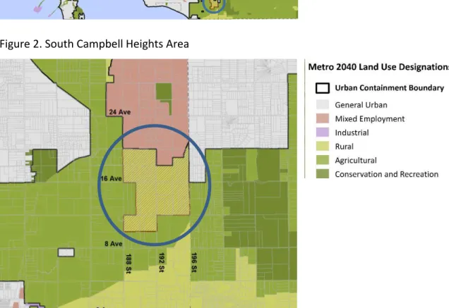
My name is Sofi Hindmarch, and I would like to make a delegation to the Metro Vancouver May 4, 2018 meeting regarding the proposed amendment to the Metro 2040 urban containment boundary for the South Campbell Heights LAP. Subject: City of Surrey's application to amend Metro Vancouver 2040: Shaping Our Future, the regional growth strategy, for the South Campbell Heights area.
3.6 On Table
The two rapid transit projects will be implemented as part of the Phase Two Investment Plan. The Phase Two Investment Plan proposes to increase service hours on the #531 (connecting Semiahmoo Municipal Town Center and Langley Regional Town Center) and increase frequency on the #375 (connecting Semiahmoo Municipal Town Center and Guildford municipal town centre).
ATTACHMENT
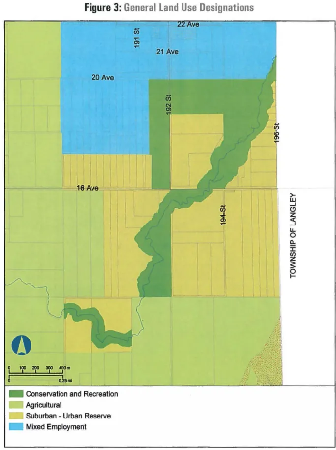
Lands Subject to the Amendment Outside of the Urban Containment Boundary Metro 2040 Amendment: Rural to Mixed Employment (37 ha)
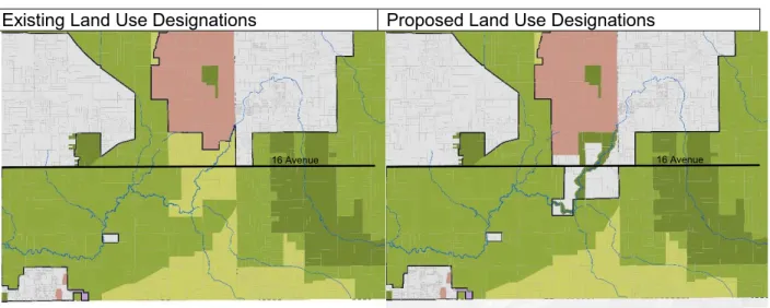
Overall, the proposed conservation and recreation designation complements the rural character of the surrounding countryside designation. Therefore, staff considers this portion of the proposed Metro 2040 land use designation amendment to be inconsistent with Metro 2040.
Lands Subject to the Amendment within the Urban Containment Boundary
Metro Vancouver 2040: Shaping Our Future Land Use Rezoning Request from the City of Surrey - South Campbell Heights Regional Planning Board Regular Meeting Date: ‐ May 4, 2018 Page 6 of 9 Metro Vancouver 2040: Shaping Our Future Rezoning Request from the City Surrey - South Campbell Heights Regional Planning Board Regular Meeting Date: ‐ May 4, 2018 Page 7 of 9 .
Lands within the Special Study Area – Rural to Agricultural (12 ha)
Metro Vancouver 2040: Future Land Use Designation Change Request Forming by the City of Surrey - South Campbell Heights Regional Planning Committee Regular Meeting: ‐ May 4, 2018 Page 8 of 9. On January 16, 2018, The City of Surrey submitted an application to Metro Vancouver to amend the Metro 2040 land use designations for the South Campbell Heights area.
- Attachment
- CORPORATE REPORTS
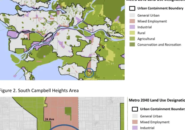
An area of land to the south of the Campbell Heights Local Area Plan (as outlined in Appendix I) of approx. 245 hectares (600 acres) are identified as a special study area in both the Metro Vancouver Regional Growth Strategy ("RGS") and the draft new Official Community Plan ("OCP"). Initiate applications to amend the RGS and Fraser Sewerage Area, including resolution of the designation of the Special Study Area.
Attachment "D"
CORPORATE REPORT
Tables detailing the planning process, the results of the background studies, the draft planning principles and the proposed land use concept were presented and discussed. Of the 47 responses submitted by people who identified themselves as residents of the study area, 26 (55%) either fully or partially supported the land use concept as presented, while 21 (45%) opposed it. Residents in the study area (48%) were more supportive of this designation than either Surrey residents outside the study area or non-Surrey residents (31% and 28% respectively).
However, staff remains convinced that the Land Use Concept as presented balances competing objectives and expresses the intent of the Planning Principles.
SOUTH CAMPBELL HEIGHTS LAP - Proposed Land Use Concept
Do you support the draft Planning Principles as presented?
Do not agree that this area should provide for a regional shortage of industrial land.
Do you propose any additional Planning Principles to those that have been presented?
Please support Objective 2 of Business Employment Zone to meet regional demand and the looming shortage of employment land in the region, especially in the logistics, warehousing and light industry sectors. Please support the goal of Special Commercial/Institutional Zone No. 3 to support a range of institutional uses and support local and unique commercial uses in the 16 Avenue corridor. Do you support the goal of Agri-Community Zone #4 to enable a unique form of integrated community agriculture, combined with clustered housing?
Do you have any specific planning questions that need to be answered or issues that need to be addressed as part of the future planning process.
Attachment "E2"
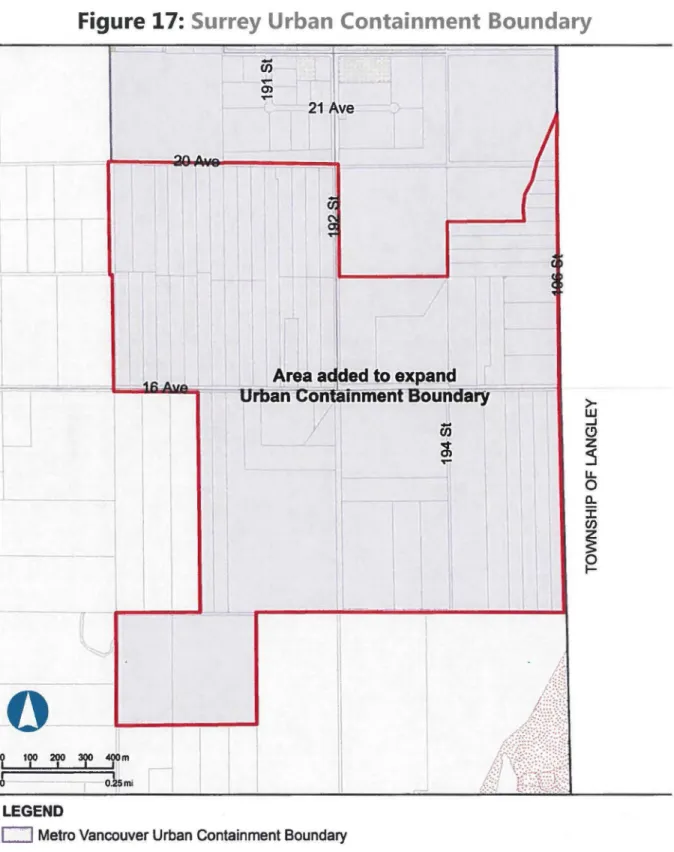
The majority of the South Campbell Heights Land Use Plan area is currently designated as Agricultural in Surrey's OCP. The majority of the South Campbell Heights Land Use Plan area is currently designated as "Agricultural" in Surrey's OCP. The South Campbell Heights land use plan area is currently outside the UCB and is identified as a "Special Study Area" in the RGS.
The Concept Land Use Plan endorsed in the South Campbell Heights Land Use Plan supports development that occurs outside the regional UCB.
South dampbelltleights Local Area-Plan
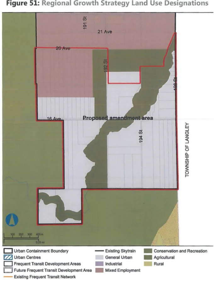
Designated Agricultural Land in the Agricultural Land Reserve - Designated agricultural land outside the Agricultural Land Reserve. 34; Figure 51: Regional Growth Strategy Land Use Determination", as illustrated in the Appendix .. a) adjust the urban containment limit of the Regional Growth Strategy;. The current land use determination is applied temporarily."; and .. c) regulate the Regional Growth Strategy Regional Land Use Designations.
SOUTH CAMPBELL HEIGHTS LAP - Proposed Land Use Concept
Attachment "F2"
Subject to the Metro Vancouver Board's approval of the amended Surrey Regional Context Statement and approval of the Regional Growth Strategy amendments, direct the City Clerk to bring Surrey Official Community Plan By-law 2013, No.
Attachment "H"
BY-LAWS AND PERMITS
This Council authorizes staff to carry out an environmental study in support of the South Campbell Heights Special Study Area Planning". The South Campbell Heights Environmental Study "Area A" comprises the land to the south of the Campbell Heights Local Area Plan as shown in Appendix I. The Campbell Heights Environmental Study "Area B" comprises land northeast of the special study area (as shown in Appendix I).
Council will be informed of the results of the environmental study for the South Campbell Heights Environmental Study "Area B" parcel of land at a future Council meeting.
Appendix II
Appendix IV
A endix V
ATTACHMENT
GVS&DD Affordable Housing DCC Waiver Bylaw Regional Planning Committee Regular Meeting Date: 4 May 2018 Page 6 of 9. GVS&DD Affordable Housing DCC Waiver Bylaw Regional Planning Committee Regular Meeting Date: 4 May 2018 Page 7 of 9. GVS&DD Affordable Housing Regional Planning Committee Regular Meeting Date: 4 May 2018 Page 8 of 9.
GVS&DD Affordable Housing DCC Dispensation statute Regional Plan Committee Ordinary meeting date: 4 May 2018 Page 9 of 9.

CITATION
INTERPRETATION
ATTACHMENT
Housing, Canada Mortgage and Housing Corporation, a not-for-profit municipal housing corporation or a registered charity, or an authorized designee of the above entities, is used to determine whether a person is eligible to occupy a housing unit in a not-for-profit rental housing development;. k) "GVS&DD" means the Greater Vancouver Sewerage and Drainage District;. l) "Group Home" means staffed residential facilities for persons with a disability who require continuous assistance to perform daily living tasks (such as taking medication, dressing or bathing); m) "Member municipality" means a municipality that is a member of GVSⅅ. Greater Vancouver Affordable Sewerage and Drainage Development Cost Exemption (n) "Non-Residential Use" means any building or structure or any part of any building or structure that is not an apartment dwelling, dwelling unit or townhouse dwelling, but for greater security , does not include any part of a building or structure for habitation which is not part of a dwelling unit and which is used or intended to be used solely for the purpose of gaining access to and from dwelling units, solely for the maintenance of the building or the structure or solely by the occupants of the dwelling units in the building or structure. o) "Not-for-Profit Rental Housing" means housing development, combination. Assistance with meal preparation or housekeeping; and (vii) consulting and outreach services; but not including personal ongoing assistance such as bathing, dressing or medication assistance provided in a group home;. s) "Registered charity" means a charitable trust or a charitable organization as defined in the Income Tax Act, R.S.C. i) The stated purpose of the registered charity's articles of association or constitution is to provide affordable housing for low (or low and moderate) income households or some other similar purpose consistent with the type of services provided;. ii) The registered charity's articles of association provide that the company's directors may not be remunerated in any capacity, nor may the directors act as employees. iii).
Greater Vancouver Sewerage and Drainage District Development Cost Exemption from Fee for Affordable (u) "Dwelling Unit" means a dwelling unit in a building or structure that. contains or may contain up to three housing units;. v) "Residential use" means apartment dwelling, residential unit, townhouse dwelling and townhouse dwelling unit;. w) "sewerage area" means any of the four sewerage areas of GVS&DD viz.
WAIVER OF DEVELOPMENT COST CHARGES
Vancouver Sewerage Area, North Shore Sewerage Area, Lulu Island West Sewerage Area and Fraser Sewerage Area;. Terms defined in Greater Vancouver Sewerage and Drainage District Development Charges Bylaw No. A reference in this regulation to a regulation includes the regulation as it may be amended or replaced from time to time.
Waiver of Development Cost Charges for Eligible Development. Notwithstanding section
RECORD KEEPING AND REPORTING
The Health and Community Design Lab at the University of British Columbia (UBC), in partnership with Metro Vancouver and TransLink, is developing a walkability index that features physical characteristics of the urban environment that support walking and cycling. Frequent Transit Corridor Studies – North Shore Seaway Complete Shaping Our Communities – Phase II Survey Results Full Transit-Oriented Affordable Housing Study – Present Phase II Full Review of Industrial and Land Policy employment mix In progress Review of urban centers and FTDA policies – Full review of FTDA policies. Frequent Transit Corridor Studies – Lougheed Corridor in Progress Urban Centers and FTDA Policy Review – Knowledge Sharing in Progress Health and Economic Results of Transit Investment Study – Ongoing Update.
Industrial and mixed use land policy review ongoing. Frequent Transit Corridor Studies - Lougheed Corridor In Progress, Urban Centers and FTDA Policy Review - Growth Overlay Structure In Progress.
ATTACHMENT