HOW CAN THE DEVELOPMENT PERMIT SYSTEM BE USED TO ACHIEVE RESIDENTIAL INTENSIFICATION OUTCOMES IN THE SUBURBS?
By:
Kelly Graham
BA (Honours), McGill University, 2011
A Major Research Paper presented to Ryerson University
in partial fulfillment of the requirements for the degree of
Master of Planning in Urban Development Toronto, Ontario, Canada, 2016
© Kelly Graham, 2016
Author’s Declaration for Electronic Submission of a MRP
I hereby declare that I am the sole author of this MRP. This is a true copy of the MRP, including any required final revisions.
I authorize Ryerson University to lend this MRP to other institutions or individuals for the purpose of scholarly research
I further authorize Ryerson University to reproduce this MRP by photocopying or by other means, in total or in part, at the request of other institutions or individuals for the purpose of scholarly research.
I understand that my MRP may be made electronically available to the public.
HOW CAN THE DEVELOPMENT PERMIT SYSTEM BE USED TO ACHIEVE RESIDENTIAL INTENSIFICATION OUTCOMES IN THE SUBURBS?
© Kelly Graham, 2016 Master of Planning
In
Urban Development Ryerson University
ABSTRACT
The Province of Ontario made the Development Permit System (DPS) available to all municipalities in 2006, with the hope that municipalities could use this new tool to achieve various policy objectives, including intensification. Under the Growth Plan, municipalities have
been instructed by the Provincial government to identify areas for redevelopment in order to meet the 40 per cent intensification target. Many suburban municipalities have been challenged to meet this target, and have requested Provincial assistance, and/or new regulatory tools. The DPS is one tool that has seen little use. This Major Research Paper explores the viability of the DPS for achieving intensification objectives in Port Whitby. The four existing DPS by-laws are compared, and other alternatives to zoning from different jurisdictions are reviewed. Lessons learned are incorporated into a set of recommendations to inform the
Town of Whitby’s approach to their upcoming Port Whitby zoning review.
Key words: Land use planning, intensification, policy implementation, planning tools
Acknowledgments
I would first like to thank my supervisor, Dr. Ron Keeble, for his useful feedback and assistance.
I would also like to thank my second reader, Richard Joy, for his enthusiasm in accepting the second reader role, and his ongoing support throughout this process.
In addition, I would like to thank the planning professionals who referred me to important resources about the Development Permit System. A special thanks to staff at the Town of Whitby who helped me understand the characteristics of the area that I selected for my case study. Thank you to my colleagues at the Greenbelt Foundation and the Ryerson City Building Institute. It was through my work with these organizations that I became passionate about the suburbs, and the pivotal role they play in the future sustainability of this region. I hope this research can assist in the creation of many healthy, complete, and vibrant suburban communities across the Greater Golden Horseshoe.
I would like to thank my family and friends for their support and encouragement. To all of you who have listened to me talk at length about a very dry, technical planning topic, I am forever grateful.
Table of Contents
1. Introduction 1
2. Methods 4
2.1. Literature Review 4
2.2. Policy Comparison 4
2.3. Applied Case Study of Port Whitby 5
3. Policy Context 6
3.1. Places to Grow 6
3.2. The Crombie Report 10
3.3. Justification for intensification 13
3.4. Challenges to Intensification 14
3.5. Regional development initiatives 17
4. Policy Review: The Development Permit System 20
4.1. Provincial legislation 20
4.2. Difference between the DPS and conventional zoning 22
4.3. Benefits of the DPS 25
4.4. Challenges of the DPS 27
5. Port Whitby Case Study 30
5.1. Context 30
5.2. Existing Regulatory Framework 31
5.3. Review of the in-force by-laws in Ontario 33
5.4. Lessons learned for Port Whitby 33
5.5. DPS policies to achieve intensification objectives 38
5.6. Using the Port Whitby planning framework to build a Development Permit System 42
6. Alternative approaches to Zoning 44
7. Reflections and Recommendations 48
8. Conclusion 50
Appendices 52
Appendix A: Port Whitby Secondary Plan Map 52
Appendix B: Port Whitby Urban Design Guidelines Character Areas 53
Appendix C: Existing zoning in Port Whitby (By-law 2585) 54
Appendix D: Development permit by-law Comparison Table 55
References 67
List of Abbreviations 72
List of Tables
Table 1: Population Growth Forecasts to 2041: Reference Scenario Table 2: Maximum review times for various planning applications Table 3: Metrolinx Mobility Hub Typology Categories
Table 4: Benefits of the DPS to municipalities, developers, and community members
List of Figures
Figure 1: Upper- and Single-Tier Municipalities in the Greater Golden Horseshoe Figure 2: Built Boundary and Settlement Area Boundary
Figure 3: Average annual intensification rates among Upper- and Single-Tier Municipalities (2007-2010)
Figure 4: All Minor Variance, OPA/Rezoning Applications, and OMB Occurrences in the City of Toronto, January 2001 to November 2013
1. Introduction
With the introduction of Places to Grow: A Growth Plan for the Greater Golden Horseshoe (MMAH, 2006) the Province of Ontario embarked on a comprehensive planning regime guided by “smart growth” principles including higher densities, intensification of existing built-up areas, and principles of transit-oriented development. The current year, 2016, marks the tenth anniversary of these policies, as well as the statutory requirement for the Province to undertake their review.
The minimum residential intensification target, one of the main pillars of the Growth Plan, was one of the challenges raised by various suburban municipalities through the
Province’s consultation process. Places to Grow requires that upper-tier municipalities across the Greater Golden Horseshoe (GGH) achieve a minimum intensification target of 40 per cent.
This means that 40 per cent of all new development should occur within the existing Built-Up Area, promoting higher densities which will allow for more efficient service delivery and support public transit. For every three dwellings built in Designated Greenfield Areas, two should be created through intensification.
Places to Grow was accompanied by population and job growth forecasts for each of the Upper- and Single-Tier municipalities, looking forward to 2031. Following the adoption of the Growth Plan, the Province directed municipalities to develop intensification strategies in order to accommodate the forecasted growth, and to bring their official plans into conformity. After undertaking this exercise, municipalities identified key locations for intensification including strategic nodes and corridors, as well as transit station areas (Filion & Kramer, 2012). Policies to help achieve this intensification have subsequently been incorporated into official plans.
Meeting the 40 per cent intensification target is more than just a matter of designating land and waiting for developers to build it. As of 2014, a number of the upper tier municipalities fell short of the 40 per cent minimum (MMAH, 2015).
For the first 10-year review of the Provincial Land Use Plans, the Province appointed former City of Toronto Mayor David Crombie to lead a panel of experts1 who would make recommendations for updating the four Plans. These include the Growth Plan, the Greenbelt Plan, the Oak Ridges Moraine Conservation Plan, and the Niagara Escarpment Plan. All of the Plans work together to limit urban sprawl and the degradation of natural systems, while promoting vibrant, dense, and connected urban and suburban communities. Even though the Plans have a lot of synergies, the four are administered by different Provincial ministries. The 2015 Review was a historic event, because it represented a more holistic and integrated approach to regional planning in Ontario. Throughout the spring of 2015, individuals,
municipalities, and organizations had the opportunity to provide feedback to the Crombie panel and share their experiences from the first decade of the Plans. Upon receipt of this feedback and following extensive community consultation, the Crombie Panel wrote a report
recommending amendments to the Plans, including a number of suggestions related to residential intensification, such as:
• Potentially increasing intensification targets, where appropriate;
• Requiring municipalities to do better reporting of their intensification rates;
• Providing guidance to municipalities to assist with policy implementation; and
• Encouraging the use of regulatory tools, including the Development Permit System (Crombie et al., 2015)
The objective of this paper is to contribute to the body of evidence for alternative regulatory tools. Traditionally, municipalities have two types of land use tools at their disposal:
regulations (zoning), and incentives (financial, or through bonusing). The Development Permit System (DPS) is a relatively new instrument that has been available to municipalities since 2006.
The Provincial Government established the DPS through Ontario Regulation 608/06, under subsection 70.2 of the Planning Act. According to the Province’s DPS Handbook (MMAH, 2008), the efficient use of land through intensification is one of the key objectives of a DPS. However, it has not yet been successfully implemented for this purpose in Ontario. To date, only four
1 Advisory Panel members included Keith Currie, Leith Moore, John MacKenzie, Rae Horst,
municipalities have implemented a DPS. These include Lake of Bays, Gananoque, Carlton Place, and Brampton.
The DPS gives municipalities the ability to promote compact form and encourage a mixture of land uses through the official plan and development permit by-law. The official plan sets out the general objectives for the DPS. The DPS by-law establishes the range of permitted uses, urban design standards, as well as the conditions whereby a proposal that falls outside of the standards could still be permitted. The body of this paper considers the potential for implementing a Development Permit System in Port Whitby. Port Whitby is an area of 183 hectares in the Town of Whitby, on the shore of Lake Ontario. Currently the area is home to 2,000 people and contains 500 jobs, but is projected to house more than six times this by 2031, with 12,500 people and 3,290 jobs (SvN Architects + Planners, 2015b).
In order to achieve these targets, the town of Whitby has commissioned a number of policy documents to guide development in the area, including a Secondary Plan, Urban Design Guidelines, and a Community Improvement Plan. These documents were received by Council in November 2015, and circulated for public input and agency comments (Planning and
Development Department, 2015). Port Whitby presently contains a mixture of land uses, including low density residential, light and heavy industrial, and recreational. The policies provide for a variety of residential forms, mixed use, institutional, and commercial land uses in Port Whitby.
The central question of this Major Research Paper is: How can a Development Permit System be used to achieve residential intensification outcomes in the suburbs? This question is explored through an initial literature and policy review to provide a framework for
understanding the policy context in Ontario. The justification for suburban intensification and its associated challenges are also reviewed. Then, a comparative analysis of existing
development permit by-laws is used to survey the use of the system in Ontario to date. The Ontario DPS examples are contrasted with a brief review of zoning alternatives from other areas of Canada, the US, and Europe. This analysis forms the basis for a set of
recommendations to inform the creation of a DPS for Port Whitby, should the municipality elect to use the system in their upcoming zoning review.
2. Methods
The classical model of urban planning practice can be traced back to Patrick Geddes and the early days of the profession (Geddes, 1915). This model, based on the ‘survey-analyze-plan’
approach, is still used to this day. This Masters Research Paper will be an inquiry into the planning phase, the final step of the process. Planners collect and analyze data, with the end goal of developing a plan for a community, area, or site. This exploratory research consists of both a literature review and a methodological study, in order to assess the utility of one tool in specific, the Development Permit System.
2.1. Literature Review
The first part of this research project is a literature review that has been undertaken to examine the suburban experience with residential intensification. The benefits of residential intensification and challenges to policy implementation are explored, in order to make the case for more efficient development patterns and practices. Second, literature and policy documents on the DPS are examined in order to understand how this instrument can support policy
objectives like intensification. The challenges to implementing a DPS are also explored.
The primary sources for this literature review include consultant reports, municipal policy documents, and newspaper or blog articles. These documents were retrieved through basic web searches as well as searches of municipal websites. The academic literature was also searched via online research databases like Scholars Portal. Relevant published research and academic dissertations were retrieved. Finally, key informants were contacted, including planners who have worked on the DPS in Ontario, for their insight into other potentially relevant documents.
2.2. Policy Comparison
The second part of this research involves a comparison of the four in-force development permit by-laws in Ontario. The by-laws of Brampton, Lake of Bays, Gananoque, and Carlton Place are compared on a number of criteria related to structure and content. They are also assessed for whether they appear to meet the stated aims of the provincial DPS legislation.
2.3. Applied Case Study of Port Whitby
The third part of this research follows an applied case study approach, in order to test the use of the Development Permit System as a planning tool to achieve intensification
objectives in Port Whitby. This area was chosen as a case study because of its identification as an intensification area in OPA 90 to the Whitby Official Plan (Town of Whitby, 2010). Port Whitby has subsequently been the subject of a custom-made regulatory framework, including a Secondary Plan, Urban Design Guidelines, and Community Improvement Plan. A comprehensive policy review provides the basis for the final product of this report: A set of recommendations for the application of the Development Permit System to guide redevelopment and
intensification in Port Whitby.
3. Policy Context 3.1. Places to Grow
The Growth Plan for the Greater Golden Horseshoe emerged as a response to rapid growth on the fringes of the Greater Toronto and Hamilton Area (GTHA) over the last half of the 20th century, consuming greenfield land at an unprecedented pace. With the recognition that the status quo could not go on, the Ontario Government created a series of plans to direct land use in the region, with the objective of accommodating an estimated 9 million more people, without substantially increasing the urban boundary. This was not a new concept to the City of Toronto, which was almost entirely built out at the time the Growth Plan was created.
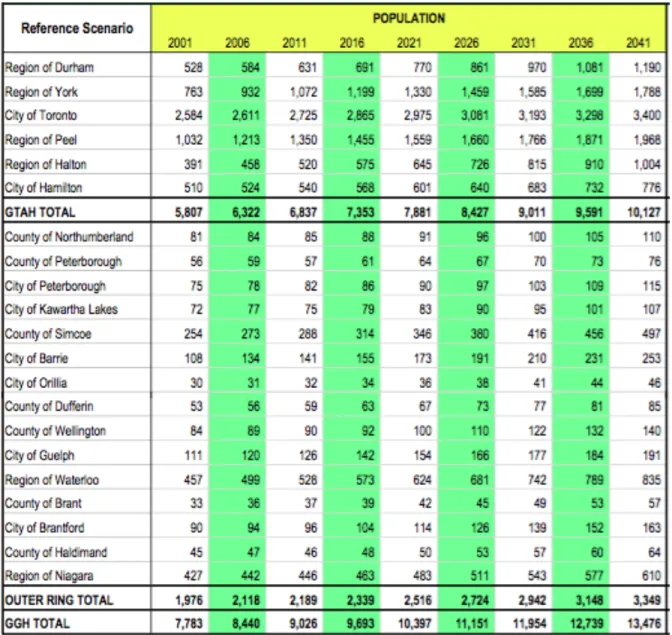
The suburbs and exurbs of the Toronto region, on the other hand, were still expanding, eating up some of the most productive farmland in the country and using infrastructure and services inefficiently, at high cost to municipalities and taxpayers. Table 1 summarizes the past and forecasted population growth for the City of Toronto and surrounding regions.
Table 1: Population Growth Forecasts to 2041: Reference Scenario (in multiples of 1000) (Hemson Consulting Ltd., 2013)
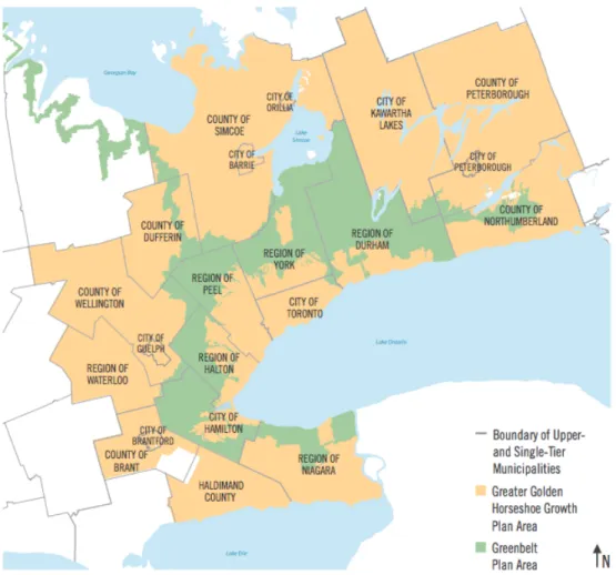
The Growth Plan area includes Toronto and the inner ring suburban municipalities in Hamilton, Halton, Peel, York, and Durham region, as well as the urban centres in the outer ring municipalities like Niagara Region, Peterborough, Barrie, Guelph, and others. These areas are quite different from Toronto, and yet, under the Growth Plan, many of the same Provincial policies apply. Figure 1 is a map of the upper tier municipalities in the GGH.
Figure 1: Upper- and Single-Tier Municipalities in the Greater Golden Horseshoe (MMAH, 2015)
Under the Growth Plan, Upper- and Single-Tier municipalities are required to establish a Settlement Area Boundary to serve as a limit to urban expansion. The Settlement Area contains both the Existing Built-Up Area, and the Designated Greenfield Area, which typically consists of farmland on the urban fringe where development is permitted (see Figure 2).
Figure 2: Built Boundary and Settlement Area Boundary (Allen & Campsie, 2013)
Upper- and Single-Tier municipalities are also required to achieve a minimum
intensification target of 40 per cent. This means that 40 percent of all new development is to occur in the existing Built-Up Area. Municipalities in the Outer Ring (i.e. beyond the Greenbelt) are permitted to request a lower target, subject to approval by the Minister. The Upper-Tier municipalities can also voluntarily set higher targets, or they can assign different targets to their Lower Tier municipalities, so long as the average is 40 per cent. Intensification is defined in the Provincial Policy Statement (MMAH, 2014) as “the development of a property, site or area at a higher density than currently exists through:
a) redevelopment, including the reuse of brownfield sites;
b) development of vacant and/or underutilized lots within previously developed areas;
c) infill development; and
d) expansion or conversion of existing buildings.”
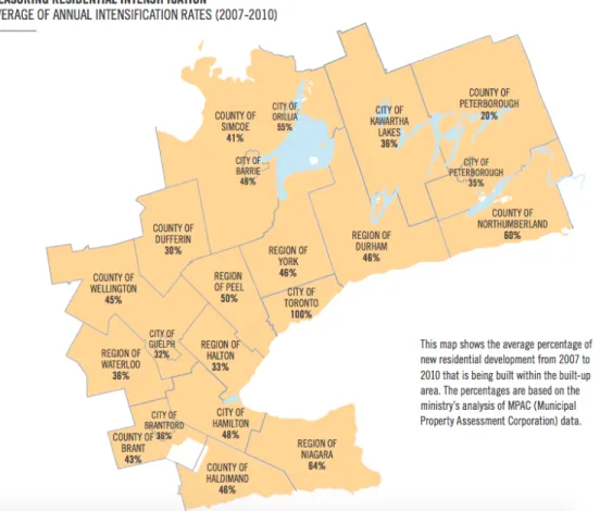
Figure 3 illustrates the intensification levels that were achieved by the upper tier municipalities between 2007 and 2010.
Figure 3: Average annual intensification rates among Upper- and Single-Tier Municipalities (2007-2010)
(MMAH, 2015)
3.2. The Crombie Report
In 2015, the Province initiated a review of the Growth Plan, along with three other regional land use plans: The Greenbelt Plan, the Oak Ridges Moraine Conservation Plan, and the Niagara Escarpment Plan. The Minister of Municipal Affairs appointed the Honourable David Crombie, former Mayor of Toronto, to lead a coordinated review of the Plans. Following months of stakeholder consultation, the Advisory panel led by Mr. Crombie released their recommendations in a report titled “Planning for Health, Prosperity and Growth in the Greater Golden Horseshoe: 2015-2041” (Crombie et al., 2015).
This report reaffirms the need for a coordinated approach to growth and development in the Greater Golden Horseshoe in order to accommodate a 50% increase in population and a
40% increase in jobs. The amount of land needed to accommodate this growth depends on the rate of intensification, and the density of new development in each municipality. Over the first decade, the Provincial Plans have had some impact in terms of decreasing land consumption.
Between 2001 and 2011 the population of the GTHA grew by 18%, but the urban area only expanded by 10% (Crombie et al., 2015).
The Crombie panel made 87 recommendations categorized under six strategic directions. The strategic directions included: Building Complete Communities, Supporting Agriculture, Protecting Natural and Cultural Heritage, Providing Infrastructure, and
Mainstreaming Climate Change, and Plan Implementation. The recommendations were based on a consideration of the advice provided during 17 Town Hall Meetings held across the GGH;
over 19,000 submissions from the public, stakeholders and municipalities; site visits to places of interest in the region; and background papers prepared by staff of various Provincial Ministries.
The Crombie Report includes a number of recommendations that are relevant to this Major Research Paper. Within the Building Complete Communities section of their report, the panel makes the following recommendations related to residential intensification (see box 1, next page).
Taken together, these recommendations reaffirm that intensification is a crucial
objective for municipalities in the Greater Golden Horseshoe, but that it should not be pursued at any cost. Intensification projects need to be integrated into existing communities with sensitivity and good design, and complemented by a vibrant public realm and improved community amenities that benefit everyone. Additionally, the Panel recommended that the Province address the feasibility of intensification projects by providing municipalities with guidance and tools to achieve the targets.
Box 1: Crombie Panel recommendations related to intensification Recommendation 1
Specify that all new developments in existing built-up areas and in designated greenfield areas should support the development of complete communities by incorporating:
- Urban design including built form, streetscapes, green infrastructure and open spaces that support human health, a pedestrian-friendly environment and a vibrant public realm (see, for example, Peel’s Healthy Community Index or Toronto’s Walkability Index - Identification and protection of cultural heritage
- Opportunities to facilitate the creation of secondary suites in new and existing building stock
- Integration of residential and retail/commercial development in a way that supports active transportation and transit
Recommendation 10
With a view to increasing intensification targets to better support the goals of the plans to sustain productive agricultural lands, protect natural resources, achieve compact urban form, support transit, reduce traffic congestion and lower greenhouse gas emissions:
- Assess and apply potential increases in intensification targets in conjunction with related recommendations in this report regarding higher density targets in designated greenfield areas, better support for transit-related intensification and stronger criteria for settlement boundary expansions (see Recommendations 14, 15 and 20)
- Require municipalities, with guidance and support from the Province, to measure and report annually on the achievement of intensification targets
Recommendation 11
Provide more specific best-practice guidance to municipalities on how to optimize
opportunities to accommodate growth within existing settlement areas in a way that supports complete communities
Recommendation 12
Address barriers to intensification and the development of affordable housing by encouraging use of tools such as up-to-date zoning, the development permit system, community
improvement plans, and reduced residential parking requirements where transit and active transportation options exist.
(Crombie et al., 2015)
3.3. Justification for intensification
The 40 per cent residential intensification target in the Growth Plan requires some explanation, particularly from a suburban point of view. Intensification can be justified from environmental, economic, social, public health, and market perspectives (Filion & Kramer, 2012). These will be discussed in turn.
First, intensification helps to protect agricultural land and natural heritage resources. If development is taking place within the existing built-up area, then there is less demand for the conversion of “white belt” lands that are valuable for food production, as well as the ecological services that nature provides (Wilson, 2013). When intensification is accompanied with
investments in transit and the public realm, it can help get people out of their cars thereby contributing fewer greenhouse gas emissions (Burda et al., 2012).
From a municipal budget perspective, infill development is far less costly to service (Blais & Slack, 2013). Land developers pay for the installation of infrastructure to service new communities on the urban fringe, but the municipality is responsible for the ongoing
maintenance of this infrastructure, and for providing both hard services (like water and sewers) and soft services (like libraries and schools) to the new communities. Due to the sprawling nature of greenfield development, the cost per capita of providing these service is much higher than in more dense areas areas (CMHC, 1997; Thompson, 2013).
Intensification is desirable from a social perspective for a number of reasons.
Intensification is a crucial ingredient for creating complete communities, where people can live, work, and play (Environmental Defense, 2015). Intensification helps communities achieve a certain level of population density, which is necessary to support local businesses and services.
From a sociological perspective, intensification creates more opportunities for social interaction. This stands in contrast to the isolating nature of conventional suburban
environments (Kuntsler, 1994). Finally, intensification can help to create a variety of housing types, which will appeal to people at different ages or income levels. This is important for social cohesion and democracy (Forrest & Kearns, 2001).
Intensification can have important public health outcomes. If intensification is
accompanied by other elements of a complete community, it can support alternative modes of
transportation (Ewing & Cervero, 2010). Population density is key to making transit viable, and transit users are more likely than automobile commuters to achieve the recommended 30 minutes of physical activity per day. In addition, complete communities with amenities and places of work that are close to where people live are also more supportive of active transportation than conventional suburbs (Frank et al., 2006).
Increasingly, intensification can be supported from a housing market perspective. A number of recent reports on housing market trends suggest that there is growing demand for complete communities, density, and transit. A 2012 study from the Pembina Institute and Royal Bank found that an overwhelming majority of residents of the Greater Toronto Area (GTA) favour neighbourhoods that are walkable, close to work and accessible by rapid transit (Burda, 2012). A recent report from the Neptis Foundation found that greenfield land consumption was slowing down, even before the Growth Plan (Neptis Foundation, 2015).
There is unprecedented evidence in support of residential intensification in suburban communities. So why do municipalities in the Greater Golden Horseshoe insist on needing more land for greenfield development? The next section will discuss a number of the difficulties municipalities face with intensifying.
3.4. Challenges to Intensification
When the Province initiated its review of the four Provincial Land Use Plans,
municipalities, stakeholders and private citizens were invited to submit their comments on the plans, and to recommend changes to the policies. A number of municipalities reported
challenges meeting the residential intensification target, and recommended that it be reduced.
Municipalities such as Guelph claim that they were only able to meet the target in the first ten years because of vacant and unconstrained land within the Built-up Area, and that, going
forward, they will not be able to achieve the target because these sites are all used up (Planning Urban Design and Building Services, 2015).
A number of factors pose real challenges to achieving the 40 per cent intensification target. Some of these factors relate to the regulatory framework, zoning in particular, while others have to do with the development process. Perception and lack of knowledge are other
key barriers, and, in many locations, the economics of intensification projects don’t make financial sense yet. These will be discussed in turn.
Regulatory Framework
In most cases, if a property owner or developer wants to build an intensification project, they will be required to apply for a zoning by-law amendment, as many forms of intensification are prohibited by the in-force zoning. Additional regulatory provisions are barriers to
intensification, including parking standards (OHBA, 2015) and parkland dedication requirements (BILD, 2011). These provisions can be impossible to meet in an infill or redevelopment situation, given the small size of intensification sites and the developer’s desire to maximize profit by building greater height and density. Where municipalities provide the option of cash-in-lieu of parkland, the formula for calculating the payment may cause the project to be financially unviable, since intensification projects in the suburbs have slimmer profit margins than downtown Toronto (OHBA, 2015).
Time and Cost
The overall time and expense of the development process can also deter property owners from pursuing an intensification project. This process can be lengthy, with the statutory public meetings, requirements for various supporting studies, and an unknown number of revisions requested by the municipality. When a site requires an official plan or zoning by-law amendment, the various procedural elements can mean an even longer delay before the first shovel hits the ground. Table 2 lists the maximum review times for various planning
applications as set out in the Planning Act. For a developer, time is money. The faster a project can be brought to market, the more appealing and feasible it is.
Zoning By-law
Amendment Minor Variance Site Plan Application Maximum
review time 120 days 30 days 30 days
Table 2: Maximum review times for various planning applications under the Planning Act
The development charges that are incurred on a per-unit basis can be the proverbial straw that breaks a developer’s feasibility calculation. Development charges are calculated as the cost to the municipality of servicing new properties, levied as a fee on that development.
They are calculated in a variety of ways, with the most common method being the cost per unit.
This favours low density, single unit residential, and discourages higher density residential forms, despite the fact that the actual cost of servicing a unit in a mid- or high-rise building is far lower than the cost of servicing a single detached home on a greenfield. A thorough
examination of development charges is outside the scope of this paper. A number of excellent publications deal with this topic, including Pamela Blais’ Perverse Cities (Blais, 2011).
Lack of knowledge
Because intensification projects differ substantially from greenfield ones, if a developer does not have experience with this kind of development they are unlikely to attempt one. In areas where intensification is a fairly novel phenomenon, there is also the market risk involved in being the first developer to take on this type of project. There may also be a lack of
knowledge about the tools and incentives available. A developer will assess the feasibility of development before they purchase a site; therefore, the policies and programs that impact a developer’s pro forma should be made explicit.
Lack of tools
As recommended by Crombie et al. (2015), municipalities need more Provincial support and tools to achieve intensification objectives. The Development Permit System is a tool that the Province made available to municipalities in 2006, and it is cited in the Crombie Report as one of the key tools that municipalities should be encouraged to employ to achieve
intensification objectives. To date, no municipality has done so. The Main Street North DPS in the City of Brampton has intensification as one of its goals, but this is not substantiated by a target number of people and jobs.
Lack of market
Every tool in the box will not be enough to encourage intensification if the market is just not there yet. Regulations can be put in place, and incentives can be offered, but developers will not build what they can not sell, and even incentives might not be enough to encourage development in an area where people have no desire to live. There is also the risk of over- regulation. A municipality can have all the policies in place, and be armed with the right regulatory tools to achieve their objectives, but developers are easily dissuaded by overly onerous processes. If a municipality wants to encourage development they also need to be somewhat flexible in their regulations.
Community resistance
A municipality may find that the existing community can put up quite a strong resistance to an intensification project. Even in Toronto where intensification is the norm, communities often resist infill projects; whether high-rise, mid-rise, or stacked townhouses. In suburban communities in the GTHA, residents may assume that “intensification” means a high-rise condo on Main Street, although this is typically not the case. Municipal planners have the
responsibility of interpreting the Provincial policies for their communities, and any explanation of intensification policies should include a discussion of the benefits of “gentle density”. This term is often used to refer to low- or mid-rise infill projects, along avenues and near nodes, that does not change the overall aesthetic or feel of the existing stable neighbourhood. Two reports from the Pembina Institute and OHBA profile different options for this type of development:
mid-rise construction (Burda & Collins-Williams, 2015), and laneway housing or secondary suites (Vijayakumar & Collins-Williams, 2015). Existing residents need to understand why intensification is important, as well as how it benefits them.
3.5. Regional development initiatives
Despite the above noted challenges, intensification projects are popping up all over the GTHA. A number of suburban municipalities, including Burlington and Brampton, are
approaching “build out”, where they have no remaining greenfield land for new development.
Mississauga was the first suburb to be entirely built out. As of 2011, all new development in Mississauga is categorized as intensification.
Intensification projects in the suburbs range from severances to create new lots in existing low-density residential areas, to the creation of new suburban downtowns with mid- to high-rise projects in areas like Mississauga, Markham, and Vaughan. Intensification is quickly becoming a fact of life in the suburban GTHA, and municipalities are adapting in different ways.
When municipalities were required to bring their official plans into conformity with Places to Grow, Peel and Waterloo Regions decided to set targets of 50 per cent and 45 per cent for intensification (Allen & Campsie, 2013), rather than the Province’s minimum 40 per cent. Other municipalities in the Outer Ring were permitted to set lower targets (MMAH, 2015).
In order to meet the Provincial target, municipalities have had to seek development opportunities within the existing built-up area. One major suburban intensification project involved the redevelopment of the former St Lawrence Starch lands along the waterfront in Port Credit, Mississauga. This award-winning project transformed 10.5 hectares of formerly industrial land into a mixed use, transit-oriented development (CMHC, 2007). The Port Credit Village development contains 410 residential units at a density of approximately 39 units per hectare, and approximately 1,400 square meters of commercial office space and 3,700 square metres of retail. The City of Mississauga is currently undertaking master planning for two other areas on the Port Credit waterfront, the former Imperial Oil lands at 70 Mississauga Road South and the area around the marina at 1 Port Street East (City of Mississauga, 2016).
But who is moving to intensification areas in the suburbs? The CMHC case study of Port Credit reports that the primary market for housing in the Port Credit Village development was empty nesters and affluent professionals. Other research shows that the desire for walkable, urban living outside of downtown Toronto has a broader appeal. In a report co-produced by RBC and the Pembina Institute, findings suggest that residents of the Greater Toronto Area prefer neighbourhoods that are walkable, close to work, and accessible by rapid transit (Burda, 2012). What about the millennial generation (born approximately 1980-2000)? A recent report from the Urban Land Institute found that while approximately 1/3 of millennial survey
respondents classified themselves as “city people”, only 13% actually lived in downtowns
(Lachman & Brett, 2015). Overwhelmingly, millennials reported a preference for denser, walkable, mixed use environments. As millennials get older and start to have children, the question remains, will they stay in the city? Trends in the United States suggest that young people are following in the parents’ footsteps, out to the suburbs. But they are choosing the older, inner suburbs, still within transit distance of downtown (Henderson, 2015).
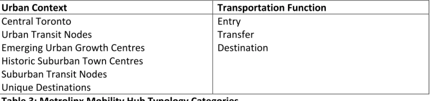
Provincial policy in Ontario is waiting for the market demand to catch up with transit and planning priorities. In 2011, Metrolinx released a set of guidelines for development around major transit stations, what they refer to as “Mobility Hubs”. The Guidelines identify 51
Mobility Hubs and establish a typology based on six urban contexts and three transportation functions (Table 3). Each mobility hub can be classified under both typologies.
Urban Context Transportation Function
Central Toronto Urban Transit Nodes
Emerging Urban Growth Centres Historic Suburban Town Centres Suburban Transit Nodes
Unique Destinations
Entry Transfer Destination
Table 3: Metrolinx Mobility Hub Typology Categories (Metrolinx, 2011)
In some cases, municipalities have integrated the Mobility Hub Guidelines into their planning policies. Metrolinx is also undertaking master planning at a number of GO station areas, where the agency owns vast parking lots and other nearby land. The Mobility Hub Guidelines will be implemented in this way, but otherwise municipalities are under no obligation to plan according to the Guidelines, and Metrolinx has no jurisdiction to regulate land use, development, or urban design. Andrew Keenan wrote his Ryerson Masters
dissertation on the potential for using the Development Permit System to implement the Mobility Hubs Guidelines (Keenan, 2012). As Keenan points out, “effectively integrating land- use regulations with proposed transit routes is important to ensuring the Plans’ [The Big Move and Growth Plan] success, and the regional transit system’s economic viability.” (Keenan, 2012,
4. Policy Review: The Development Permit System
At the Second National Conference on City Planning and Congestion in 1910, Frederick Law Olmstead Jr. said:
“regulation should always be in a state of flux and adjustment, on the one hand, with a view to preventing newly discovered abuses, and, on the other hand, with a view to opening a wider opportunity of individual discretion at points where the law is found to be unwisely restrictive” (Talen, 2012, p. 176).
It was in this spirit that the Government of Ontario made the Development Permit System available as an alternative approach to land use regulation.
4.1. Provincial legislation
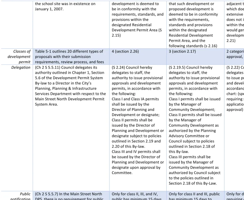
The Development Permit System (DPS) combines zoning, site plan control, and minor variance into a single streamlined process. The DPS is permitted under subsection 70.2 of the Planning Act. It gives municipalities the ability to promote compact form, and encourage a mixture of land uses through the official plan and development permit by-law. Site-specific elements such as setbacks, parking, and urban design can be addressed at the development permit stage, without the need for a minor variance or zoning by-law amendment (MMAH, 2008). Ontario Regulation 608/06 specifies that the council of a municipality is the approving authority, which removes the role of the Committee of Adjustment. Council can also delegate approval authority to a committee of council, a committee appointed by council, or staff.
The Provincial regulation (O. Reg. 608/06) outlines the procedure for implementing a DPS (Province of Ontario, 2006). A municipality must follow the steps as described in Box 2:
Box 2: Steps to establishing a Development Permit System
1. Council must pass an amendment to the Official Plan to allow for the creation of a DPS By-law. The Official Plan must specify:
a) The area where the system will apply
b) The scope of authority that may be delegated to staff or a committee c) The specifications for the areas under the by-law, including:
I. The municipality’s goals, objectives, and policies
II. The performance-based criteria that will be used to determine whether any development may be permitted
III. Potential conditions that may be imposed through the DPS The Official Plan Amendment may also specify:
I. The information and materials that are required for a complete DPS application
II. The classes of development that are covered by the DPS, and any classes that may be exempt III. The requirements for the provision of specified services, facilities and other matters in exchange for
height and density
2. After passing the Official Plan amendment, Council can direct staff to prepare the Development Permit System By-law which contains:
a) A description of the area to which the by-law applies b) Permitted and discretionary uses and definitions
c) Minimum and maximum standards for development and permitted variations d) Review and notice procedures
e) The process for amending development permits f) Actual conditions of approval
g) Scope of delegated authority, including any limitations The by-law may also contain:
a) Prohibitions of any development or change in land use without a permit b) Defined classes of development
c) Exemptions for any defined class or land use from requiring a development permit
d) List of classes of development or land uses that may be permitted if the criteria in the OP and by-law have been met (discretionary uses)
e) Criteria that council may use to evaluate an application f) Range of possible variations from the development standards
3. A landowner or developer may apply for a development permit with respect to land that is subject to the development permit by-law. Council can require that additional information and materials be included, and can refuse to consider the application until the information and materials are provided.
4. On consideration of a development permit application, council or staff may:
a) Refuse the application;
b) Approve the application and issue a development permit with no conditions attached;
c) Approve the application and require that conditions be met before issuing a development permit;
d) Approve the application, require that conditions be met before issuing a development permit and, when the conditions have been met, issue a development permit with conditions attached.
5. If the council fails to make a decision within 45 days after the date on which the information and material and fee are received, the applicant may appeal to the Municipal Board against the failure to make a decision.
6. Once the final decision has been issued, only the applicant has the power to appeal the decision to the OMB.
4.2. Difference between the DPS and conventional zoning
The roots of conventional zoning can be traced back to the 1926 US Supreme Court Case Village of Euclid vs. Amber Realty. This case established that zoning, as a form of government control over individual property rights, was constitutional. Euclidean zoning allocates single-use categories to areas or blocks, and maintains separation between potentially disharmonious uses (Hirt, 2013). Like a conventional zoning by-law, the DPS is a document that regulates the use of land and incorporates various standards that are applied along with permitted and discretionary uses. It can also include provisions for variations to development standards, provided that the proposed development meets a number of pre-defined criteria. The
definition of development under a DPS is expanded, relative to that in a zoning by-law. Because of this, a DPS can incorporate regulations around heritage preservation, urban design, tree cutting, and site alteration. In addition to replacing the zoning by-law (S 34 of the Planning Act), the DPS by-law also replaces Section 41 (Site Plan Approval), and Section 45 (Powers of
Committee).
The DPS process is a departure from conventional development application procedures because it combines the application for zoning by-law amendments, minor variance, and site plan approval into a single process, with a 45-day turnaround time. Before a developer or landowner submits a development permit application, they may be required to meet with staff in order to determine what studies will be required, and what conditions might be imposed before approval can be issued. The DPS by-law specifies the criteria that will be used to evaluate an application, and these are known by proponents in advance.
One of the main differences between the a DPS by-law and a zoning by-law concerns the use of conditions on development. Conditions can be imposed that must be met prior to a permit being issued, or attached to the permit itself. The types of conditions must be explicitly described in the OP Amendment and the DP by-law, and can include:
• conditions related to the removal or restoration of vegetation;
• conditions related to site alteration;
• conditions related to the provision of specified facilities, services and matters in exchange for a specified height or density. (Meridian Planning Consultants Inc., 2008)
The conditions must be clear, precise, and quantifiable, and must not deal with interior layout or design, or the manner of construction and construction standards, and they must be satisfied to a standard that is satisfactory to council. The DPS is different from conventional zoning, because the current zoning system does not leave room for variation. If a developer wants to build something other than what is permitted as-of-right, they will need to apply for a minor variance or zoning by-law amendment. Through this process, municipal planners are able to negotiate various conditions. The preponderance of these types of negotiations has led to the labelling of the current approach as “lets make a deal planning” (Garrett, 2012).
The DPS has been promoted as a “policy-first” approach to land use regulation. Because of this, the municipality should strive for meaningful public consultation in the creation of the by-law. This is an opportunity for planning staff, politicians, and community members to discuss their objectives and hopes for the future. Planning staff are responsible for creating the
conditions for high quality dialogue, where participants feel they are being listened to. Staff might look to the lessons learned from communicative planning theory (Healey, 1992) when they are considering their approach. The agreed-upon vision resulting from this engagement can be written in to the policies of the DPS so that any new development can be evaluated against how well it supports the community’s goals for the future. Once the DPS is in place, there are no third party rights to appeal an application.
Under the current system, there are statutory requirements for public meetings regarding any zoning by-law amendment, and neighbours have the right to oppose a minor variance application at a Committee of Adjustment hearing. After the municipality approves either type of application, members of the public still have the right to appeal the decision to the Ontario Municipal Board (OMB). At the OMB hearing, lawyers for the proponent, the municipality, and the appellants make a case for what they consider to be “good planning”.
There are many issues with the OMB, and the Province is currently undertaking a review of its role. It should be noted that, under the DPS, the role of the OMB is restricted to general appeals on the official plan policies or by-law. After the by-law has been passed, only the applicant has the right to appeal the municipality’s decision.
The DPS implies a greater role for planning staff. Because the DPS by-law contains provisions for variations on the development standards, each application is essentially
considered “as-of-right”. O. Reg. 608/06 specifies that municipal councils have the authority to establish a development permit by-law, to approve or reject applications under such a by-law, and that the scope of authority can be delegated to staff. Certain categories of development may be considered more minor, such as tree removal or changes to an existing building. Other categories, such as a new construction or a lot severance, would require the approval of
Council. This is different from the existing approach, where minor variances are directed to the Committee of Adjustment, while Site Plan Applications and Zoning By-law Amendments go to Council.
In his presentation for the Centre for Urban Research and Land Development at Ryerson University, Toronto Planner Joe D’Abramo concluded that comprehensive zoning by-laws are no longer serving the purpose of as-of-right certainty in development-intensive communities (D’Abramo, 2014). This is due to the preponderance of site-specific amendments and re-zoning that have occurred, with the result that the actual built form of the city is inconsistent with the as-of-right zoning. The map in Figure 4 illustrates the number of minor variances, re-zonings, and official plan amendments in the city of Toronto between January 2001 and November 2013.
Figure 4: All Minor Variance, OPA/Rezoning Applications, and OMB Occurrences in the City of Toronto, January 2001 to November 2013
(D’Abramo, 2014)
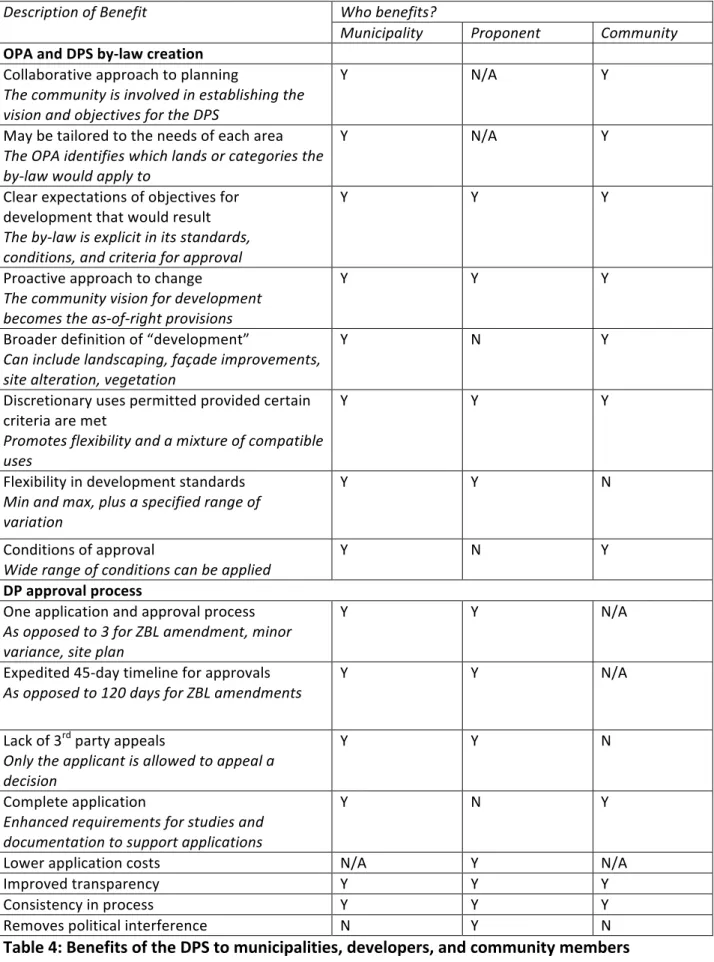
4.3. Benefits of the DPS
The intended benefits of a Development Permit System have been well documented. In the Development Permit System Handbook (MMAH), the Ministry of Municipal Affairs and Housing outlines the benefits related to efficiency, policy implementation, flexibility, and time.
Through a review of this document, and other commentary about the DPS, the benefits of the system were identified. Table 4 lists the potential benefits, and whether they would accrue to the major stakeholders (municipalities, proponents, and the community).
Description of Benefit Who benefits?
Municipality Proponent Community OPA and DPS by-law creation
Collaborative approach to planning
The community is involved in establishing the vision and objectives for the DPS
Y N/A Y
May be tailored to the needs of each area The OPA identifies which lands or categories the by-law would apply to
Y N/A Y
Clear expectations of objectives for development that would result The by-law is explicit in its standards, conditions, and criteria for approval
Y Y Y
Proactive approach to change
The community vision for development becomes the as-of-right provisions
Y Y Y
Broader definition of “development”
Can include landscaping, façade improvements, site alteration, vegetation
Y N Y
Discretionary uses permitted provided certain criteria are met
Promotes flexibility and a mixture of compatible uses
Y Y Y
Flexibility in development standards Min and max, plus a specified range of variation
Y Y N
Conditions of approval
Wide range of conditions can be applied Y N Y
DP approval process
One application and approval process As opposed to 3 for ZBL amendment, minor variance, site plan
Y Y N/A
Expedited 45-day timeline for approvals
As opposed to 120 days for ZBL amendments Y Y N/A
Lack of 3rd party appeals
Only the applicant is allowed to appeal a decision
Y Y N
Complete application
Enhanced requirements for studies and documentation to support applications
Y N Y
Lower application costs N/A Y N/A
Improved transparency Y Y Y
Consistency in process Y Y Y
Removes political interference N Y N
Table 4: Benefits of the DPS to municipalities, developers, and community members
4.4. Challenges of the DPS
In his Major Research Paper for the Local Government Program at the University of Western Ontario, Joe Netherly outlines eight hypotheses for why there has been so little uptake of the Development Permit System in Ontario:
1. The natural conservatism of Ontarians;
2. council desire to maintain power;
3. a catalyst event having or not having occurred;
4. activist theory criticisms on curtailed public comment;
5. lack of knowledge of DPS;
6. satisfaction with a current framework for approvals;
7. time or cost concerns;
8. certain demographic or municipal structural concerns.
(Nethery, 2011)
Mr. Netherly conducted a survey of 303 senior planning administrators in Ontario in order to determine which of these hypotheses could explain respondents’ consideration of the DPS. He determined that lack of knowledge about the system was a statistically significant factor in explaining a lack of consideration of the DPS. Netherly also found that respondents from municipalities with a higher number of OMB cases were more likely to have considered the DPS. From this it was suggested that until planners are faced with more challenging development proposals, they are likely to think that existing zoning system is sufficient.
This study provides important insight into why planners have or have not considered the DPS, but it does not address the hypothesized challenges from any other perspective. Like in section 4.3, the challenges to the DPS will now be discussed according to the various
stakeholder groups involved.
Municipality
A City of Barrie staff report contains a summary of planning staff’s investigation into the DPS (Infrastructure Development and Culture, 2011). The staff report raises two concerns:
1) the time and cost required to craft a Development Permit By-law;
2) the risk of setting inadequate standards and development criteria, resulting in a less effective by-law.
Planners from the City of Brampton have given a number of presentations regarding their experience implementing the DPS for Main Street North. In an October 2014 presentation at Ryerson University, they discussed their challenges including:
1) the complex range of building characteristics in the study area;
2) the need for ongoing education and training for staff, stakeholders, Council, and the public;
3) uncertainty about how best to structure the document.
(City of Brampton Planning Department, 2014)
An additional challenge for the municipality is ensuring that the up-front community engagement that goes into creating the policies is of high quality, and that it has involved a broad spectrum of the public. Municipalities regularly hold public meetings for development proposals, community plans, and other planning studies, but this engagement is of varying quality. It is an important obligation for planners to make sure that the policies in the DPS reflect the vision and objectives of residents, because once the policies have passed, the community no longer has the right to appeal a development decision.
The 45-day timeline could also prove to be a challenge for municipalities, especially for classes of development that require Council approval. If there is not enough time to get the application on the agenda for Council or a Committee, then they cannot approve it within the 45 days, and the proponent has the right to appeal the lack of decision to the OMB.
Proponent
A review of the submissions to Toronto City Council for their consideration of the Development Permit System identified a number of letters from representatives of the
development industry (Toronto City Planning, 2014). These letters voiced some concerns about the proposed Official Plan Amendment to implement the DPS. These parties were apprehensive that the policies created excessive discretion for City planners, leading to greater uncertainty in
the process—a matter the DPS was intended to correct. Some were also concerned that the process for amending a development permit by-law would be overly onerous, and
recommended that the City incorporate policies similar to the minor variance process.
In general, developers lack understanding of the development permit application process and are unsure of how to negotiate the conditions that could be imposed on a new project. Typically, developers prefer jurisdictions with the most permissive regulations, so an overly complex DPS with layers of regulations could serve as a deterrent to development in a DPS area. This is an unfortunate irony, but it reflects the popular idiom “better the devil you know than the one you don’t”. Future research might look at the development applications received by the City of Brampton under the Main Street North DPS. At time of writing, there have been no applications since the OMB gave the policies final approval in October, 2015.
Community
A presentation by Jessica Wilson, Vice Chair of the Confederation of Resident and Ratepayer Associations (CORRA) in Toronto, outlines some of the community concerns with the DPS (J. Wilson, 2014). The primary community concern is the lack of third party appeals to a development decision. As discussed in Table 4, this can be seen as a benefit to the municipality and developer, but it removes the public from the development process. Wilson was also apprehensive that, even after extensive community consultation, the approved by-law would not reflect the community vision, particularly with regard to height and density. The third concern that Wilson brought up was the delegation of decision making, removing both residents and the people who they have elected to represent them from having a say in
development decisions. The final worry from the residents’ perspective was the lack of funding available for DPS studies for each individual neighbourhood, and would this result in more generic DPS guidelines that would apply across the city?
The benefits and challenges discussed above will now be applied to a specific case study, where they will be considered in the context of the Port Whitby area.
5. Port Whitby Case Study 5.1. Context
The history of the Town of Whitby is directly linked to the establishment of the harbour at Port Whitby, which was long considered to be one of the best harbours on the North Shore of Lake Ontario. Port Whitby became a busy commercial port, where goods were exchanged between boats and surface transportation. A railway was constructed in 1871 connecting Port Whitby and Port Perry to the north, to transport grains from the northern farms of the region.
In the 20th century, Port Whitby became an important industrial hub, with manufacturing, oil storage, and commercial shipping. Many of these former factory, marine, and oil refinery properties are still in use for other purposes, though some are currently vacant. Port Whitby has evolved into a harbour for pleasure crafts rather than freight shipping, with a large marina, lakefront greenway, and other recreational amenities.
Employment numbers in Port Whitby have declined along with the decline of industry.
Currently, employment in the area is primarily retail and service jobs, catering to the surrounding residential community and those nearby. The area is bordered to the east and west by large employment areas. At the north end of Port Whitby, the Whitby GO station provides 30-minute service to and from downtown Toronto along the Lakeshore East line. The residential areas in Port Whitby contain an eclectic mix of low, mid, and high rise housing, with a variety of architectural styles and construction techniques.
Amendment 90 to the Whitby Official Plan identifies Port Whitby as an area for intensification in order to meet the town’s population and job targets as set out by Regional Official Plan Amendment (ROPA) 128 (Durham Region, 2009; Town of Whitby, 2010). Both of these amendments were required in order to bring both the regional and local plan into conformity with the Growth Plan (MMAH, 2006). OPA 90 sets a target of 10,500 more people and 3,290 more jobs in the Port Whitby/Whitby GO station area by 2031. Planning staff at the Town were directed to create policies to guide this dramatic intensification.
5.2. Existing Regulatory Framework
In November of 2015, staff presented the planning framework to guide development in Port Whitby to the Planning and Development Committee of Council (Planning and Development Department, 2015). This included draft versions of the Secondary Plan (SP), Community Improvement Plan (CIP), and Urban Design Guidelines (UDG). The Town hired consulting firm SvN Architecture + Planning (formerly Planning Alliance) to coordinate the project and
complete the three documents. The draft documents have been circulated for public input and agency comment. Once all feedback has been received, reviewed and assessed, final
recommendations will be brought forward for adoption by Council.
The Secondary Plan provides an update to the Whitby Official Plan in order to ensure
“that future planned land uses in the Port Whitby area reflect long term community needs, allow for an environment of self-sufficient economic prosperity in Port Whitby, and help to develop the waterfront as an anchor with linkages to the existing downtown” (Planning and Development Department, 2015). Some of the key objectives of the secondary plan include:
achieving the intensification targets for people and jobs, improving the vibrancy of the Port Whitby area, and promoting sustainable transportation options.
Please refer to Appendix A for a map of the land use designations in the Secondary Plan.
The Secondary Plan includes policies to ensure that sustainability and urban design matters are addressed through the development approval process. It also has additional policies that provide for enhanced urban design, including: landscaping, architectural character and the public realm (SvN Architects + Planners, 2015b). The Secondary Plan establishes the regulatory weight of the accompanying Urban Design Guidelines, which enhance the policies in section 6.2 and section 11.1. The two documents are to be read together during the review of a
development application. In addition, the Secondary Plan specifies that, for certain proposed developments, an Urban Design Plan maybe required as part of a complete application. It does not specify under which conditions an Urban Design Plan would be necessary, but that the UDG would be used to evaluate the proposed development. Policies 11.1.17.3 and 11.1.17.4 give additional weight to the UDG for landscaping and plantings, as well as the restoration of enhancement of building facades.
The Secondary Plan makes it very clear that matters of urban design are a priority for the redevelopment or Port Whitby. The UDG set out specific development strategies for Port Whitby as a whole and for four specific sub areas: The GO station site, Brock Street South, the Waterfront Area, and the Stable Low-Rise Neighbourhood (Dufferin Street) (SvN Architects + Planners, 2015c). See Appendix B for a map of the four sub-areas where different urban design policies apply. The UDG emphasize public realm improvements, gentle transitions between new development and the existing neighbourhood, and a pedestrian scale.
The Secondary Plan and Urban Design Guidelines can be considered the regulatory
“sticks” to guide development in Port Whitby, but the policymakers in Whitby recognized that they would need a range of “carrots” as well, to incentivize the kind of change that is sought.
The Port Whitby Community Improvement Plan (CIP) was developed on the basis that
redevelopment initiatives should act as a catalyst for future development in Port Whitby. A CIP is a tool under Section 28 of the Planning Act that allows municipalities to provide incentives for development within specifically defined areas. The Port Whitby CIP also includes priorities for municipal investment, including the redesign of Watson Park and active transportation network improvements (SvN Architects + Planners, 2015a). The CIP lays out various options for
incentives that are designed to encourage private sector investment, redevelopment, and construction activity in Port Whitby. The recommended options include façade and building revitalization grants, tax increment grants, brownfield tax assistance, grants for seeking design advice, and development charge exemptions.
One proposed CIP program that is relevant to this paper is the Residential Intensification grant, to encourage landowners to add secondary suites to existing residences or to retrofit existing multi-unit buildings. The program would provide a grant equal to the costs of
rehabilitating existing residential units and/or constructing new residential units on the basis of
$15 per square foot of habitable floor space rehabilitated or constructed to a maximum grant of $15,000 per unit and a maximum of 4 units per property/project (SvN Architects + Planners, 2015a).
The CIP acknowledges that the zoning regulations for Port Whitby should be updated to reflect the preferred land use scenario in the Secondary Plan. The existing land use designations