Aquatic community patterns across environmental gradients in a Mediterranean floodplain and their application to ecosystem restoration
169
0
0
Texto completo
(2) Front photograph: Joaquín Guerrero.
(3) Aquatic community patterns across environmental gradients in a Mediterranean floodplain and their application to ecosystem restoration Ph‐D dissertation Belinda Gallardo Zaragoza‐Girona, 2009.
(4)
(5) Aquatic community patterns across environmental gradients in a Mediterranean floodplain and their application to ecosystem restoration. Memoria presentada por Belinda Gallardo Armas para optar al grado de Doctora por la Universidad de Girona. Visto bueno del director:. Visto bueno de la directora:. Dr. Francisco A. Comín Profesor de Investigación Dept. Ecología funcional y biodiversidad Instituto Pirenaico de Ecología Centro Superior de Investigaciones Científicas. Dr. Stephanie Gascón Profesora Asociada Dept. Ciencias Ambientales Instituto de Ecología Acuática Universidad de Girona. La doctoranda:. Belinda Gallardo Armas Girona, 2009.
(6)
(7) This researching work was supported by Projects from the Aragon Government (2003‐2007. “Assessment of the aquatic and intermittently flooded habitats of the Galachos Natural Reserve to propose management and restoration guidelines”), from the Spanish Ministry of Education and Sciences (2005‐2008. ”Scientific bases for wetland restoration at floodplains in the Middle Ebro River” MEC CGL2005‐07059‐C02‐01) and by a pre‐doctoral grant from the Aragon Government (2005‐2008. B081/2005)..
(8)
(9) Index Abstract. 1. Abstract. 1. Resumen (Castellano). 3. Resum (Català). 5. General Introduction. 7. Main drivers of floodplain ecosystems. 9. Aquatic community patterns across hydrological and environmental gradients 12 Current situation. 13. Objectives. 16. Study Approach. 17. General Methodology. 19. Study Area. 21. Sampling scales. 21. Hydrological setting. 25. Sampling procedure. 27. Results. 31. Chapter 1— Main environmental factors determining the taxonomic composition and diversity of aquatic communities across the lateral hydrological connectivity. 33. Abstract. 33. Introduction. 33. Material and Methods. 35. Results. 38. Discussion. 44. Chapter 2— Modelling the response of floodplain aquatic assemblages across the lateral hydrological connectivity. 50. Abstract. 50. Introduction. 50 i.
(10) Material and Methods. 52. Results. 56. Discussion. 61. Chapter 3— Main hydrological and environmental factors determining the functional composition and diversity of aquatic communities across the lateral hydrological connectivity. 66. Abstract. 66. Introduction. 66. Material and Methods. 69. Results. 73. Discussion. 77. Chapter 4— Testing the response of the macroinvertebrate functionality to flooding and confinement. 81. Abstract. 81. Introduction. 81. Material and Methods. 83. Results. 86. Discussion. 91. General Discussion. 97. Aquatic community patterns across hydrological and environmental gradients 99 The Ebro in the context of other river‐floodplains. 103. Applications to the restoration of a regulated Mediterranean floodplain. 106. Conclusions. 109. Conclusions. 111. Conclusiones (Castellano). 114. Conclusions (Català). 117. References cited. 121. Appendices. 133. Agradecimientos. 154. ii.
(11) List of Tables Table 1 Principal studies analyzing the effect of the river discharge.. 14. Table 2 General characteristics of wetlands included in the stretch scale.. 22. Table 3 General characteristics of wetlands monitored at the Middle Ebro sector scale.. 24. Table 4 Hydrological surrogates used in this study.. 27. Table 5 Hydrological connectivity definitions for wetlands in the Ebro River.. 36. Table 6 Water characteristics of wetlands included in Chapter 1.. 38. Table 7 Invertebrate composition and attributes of wetlands included in Chapter 1.. 38. Table 8 General features, LHC surrogates and biological attributes used in Chapter 2.. 54. Table 9 Spearman correlations (rS) among LHC surrogates used in Chapter 2.. 55. Table 10 Results of GAMs performed between biological attributes and LHC surrogates.. 56. Table 11 Functional classification of invertebrates appearing in the Ebro floodplain.. 70. Table 12 Mean values of hydrological and environmental descriptors.. 72. Table 13 Mean values of functional groups abundance, richness and diversity.. 74. Table 14 Results of RDA performed in Chapter 3.. 75. Table 15 Biological traits and modalities for invertebrates considered in Chapter 4.. 84. Table 16 Mean of environmental variables measured in flooded and confined sites.. 87. Table 17 Results from fourth‐corner analysis in flooded sites.. 89. Table 18 Results from fourth‐corner analysis in confined sites.. 90. Table 19 Rivers used for comparison with the Ebro River.. 104. Table 20 Benefits and risks of restoration activities.. 107. List of Figures Figure 1 Schematic view of a free flowing meandering river and a regulated river.. 11. Figure 2 Theoretical distributions of biodiversity across the lateral hydrological connectivity.. 13. Figure 3 Rainfall and temperature diagrams.. 15. Figure 4 Schematic view of main objectives accounted for in the thesis.. 17. Figure 5 Localization of the study area in the middle sector of the Ebro River.. 23. Figure 6 Substrate size in wetlands included in the stretch‐scale sampling.. 23. Figure 7 Hydrograph of the Ebro River at Zaragoza gauging station.. 27. Figure 8 Example of sampling procedure in a floodplain wetland.. 28. Figure 9 Abundance of main invertebrate groups in six wetlands and the Ebro River.. 40. Figure 10 Results of Correspondence Analysis (CA) performed in Chapter 1.. 41. Figure 11 Environmental variables showing differences between seasons.. 41. Figure 12 Results of Canonical Correspondence Analysis (CCA) performed in Chapter 1.. 43. Figure 13 Results of box‐plots and GAM analyses performed in Chapter 1.. 44. Figure 14 Response of macroinvertebrate richness and abundance to LHC surrogates.. 57. iii.
(12) Figure 15 Response of zooplankton richness and abundance to LHC surrogates.. 58. Figure 16 Response of phytoplankton richness and abundance to LHC surrogates.. 58. Figure 17 Results of RDA performed in Chapter 2.. 59. Figure 18 Functional groups composition of the Ebro River and three oxbow lakes.. 74. Figure 19 Functional groups richness and diversity in the Ebro River and three oxbow lakes.. 75. Figure 20 Results of Redundancy Analysis performed in Chapter 3.. 76. Figure 21 Functional groups distribution across environmental gradients.. 77. Figure 22 Results of CCA performed in Chapter 4.. 88. Figure 23 Number of significant relationships of the fourth‐corner statistic.. 88. Figure 24 Trait diversity and richness in flooded and confined sites.. 91. Figure 25 Template of habitat conditions and the response of aquatic communities.. 101. Figure 26 Patterns in macroinvertebrate richness in four different floodplains.. 106. iv.
(13) Para Nacho, que me ha aguantado cuatro años de carrera, cuatro años y pico de tesis, y los que nos quedan…. v.
(14) vi.
(15) Abstract. Abstract In Europe and North America, up to 90% of floodplains have become extensively regulated, occupied, and polluted, with important consequences in the floodplain structure and functionality. The response of this ecosystem to human alteration is complex and its study is of great relevance in the development of management plans to effectively counteract the influence of negative human impacts. To address these needs, the present study provides a solid background for river‐floodplain restoration through the investigation of the response of aquatic communities, especially macroinvertebrates, to changes in hydrological connectivity, environmental factors and human pressure across the floodplain of a Mediterranean system, the Middle Ebro River (NE Spain). Our results showed how the lateral hydrological connectivity is the key factor structuring the habitats and aquatic communities of the Middle Ebro floodplain. This hydrological connectivity was related to a wide variety of environmental processes affecting directly and indirectly the presence of aquatic organisms, from habitat re‐organization to nutrient transport. Moreover, hydrological connectivity explained at least one third of the macroinvertebrate species and trait composition, and more than half of the observed variability in the abundance and richness of macroinvertebrates, zooplankton and phytoplankton. Turbidity, salinity and nutrient status were secondary drivers, although essential for understanding the adaptation of aquatic communities to the floodplain environmental variability. On the other hand, the present study allowed identifying surrogates of hydrological fluctuations that were useful to assess the abundance, richness and composition of aquatic communities. For instance, the macroinvertebrate community depended on the duration of the connections established between each wetland and the river channel, whereas organisms with short life‐cycles, like phytoplankton and zooplankton, responded better to water‐level fluctuations. The combination of hydrological connectivity and environmental variability create a spatio‐temporal template for the aquatic community that enables predictions about the taxonomic and functional patterns more likely to occur under particular conditions. According to the Ebro template (a) frequently flooded habitats, as the river channel and adjacent wetlands, were dominated by insects and aquatic worms that showed disturbance resistance (e.g., small body‐shape, protection of eggs) and resilience (e.g., short life‐span, asexual reproduction) abilities, (b) by contrast, confined wetlands that are rarely flooded, including oxbow lakes, were dominated by non‐insect taxa, as crustaceans and gastropods, showing the ability to interact with other organisms (e.g., large size, sexual reproduction), as well as to effectively use habitats and resources (e.g., diverse locomotion and feeding strategies), (c) the combination of habitat heterogeneity and nutrient availability under intermediate hydrological conditions resulted in highest macroinvertebrate species and trait diversity and, (d) the abundance and richness of three different groups of organisms (zooplankton, 1.
(16) Abstract. phytoplankton and macroinvertebrates) peaked at increasing levels of hydrological connectivity (flooded during 5, 30 and 40 days yr‐1 respectively). In the Middle Ebro River, progressive regulation of river flow has altered the natural river‐floodplain interaction. Consequently, there are very few possibilities of new wetlands creation, while the diversity and functionality of the remaining ones are threatened by the limited hydrological connectivity. The objective of river‐floodplain restoration in the Middle Ebro River should thus consist in re‐establishing a wide range of wetland types in accordance with the river‐floodplain potential for ecological sustainability. In order to achieve this, a number of actions can be positively performed, such as the modification of embankments, the re‐connexion of isolated floodplain habitats, the creation of new wetlands, the recovery of unproductive areas of the floodplain and the control of the water quality at a catchment scale.. 2.
(17) Abstract. Resumen (Castellano) Aproximadamente el 90% de las llanuras de inundación de grandes ríos europeos y norte‐americanos se han visto fuertemente reguladas, ocupadas y contaminadas en las últimas décadas, con importantes consecuencias sobre la estructura y funcionalidad del ecosistema fluvial. La respuesta de este ecosistema a dichos cambios es compleja y su estudio resulta imprescindible para la efectiva implementación de planes de gestión que contrarresten el impacto negativo de las actividades antrópicas. La presente tesis ofrece una base de conocimiento para la restauración de ecosistemas fluviales a través de la respuesta de las comunidades acuáticas, especialmente macroinvertebrados, a cambios en las condiciones hídricas, factores ambientales y presión antrópica a través del gradiente hídrico lateral que se establece de forma natural entre el río y su llanura de inundación. Esta tesis se enmarca en el ámbito de un ecosistema mediterráneo, el río Ebro en su tramo medio (NE, España). Los resultados obtenidos muestran como la conectividad hídrica lateral es el factor principal que determina la estructura de hábitats y comunidades acuáticas en el Ebro Medio. Esta conectividad está relacionada con un amplio abanico de procesos que afectan directa o indirectamente la presencia de organismos acuáticos, desde la reorganización de hábitats al transporte de nutrientes. Asimismo, la conectividad hídrica es responsable de al menos un tercio de la composición de especies y rasgos biológicos de la comunidad de macroinvertebrados, y de más de la mitad de la variabilidad observada en la abundancia y riqueza de macroinvertebrados, zooplancton y fitoplancton. Otros factores importantes e imprescindibles para comprender la adaptación de las comunidades acuáticas a la heterogeneidad natural de la llanura de inundación, incluyen características físico‐químicas como la turbidez, salinidad y estado trófico. Por otro lado, el presente estudio permite identificar un conjunto de variables relacionadas con las fluctuaciones hídricas con las que estudiar la respuesta de las comunidades acuáticas. Por ejemplo, la composición, riqueza y abundancia de macroinvertebrados depende en gran medida de la duración de la conexión hídrica que se establece entre su hábitat y el cauce fluvial, mientras que organismos con ciclos vitales más cortos, como zooplancton y fitoplancton, responden mejor a variaciones en el nivel del agua. La combinación de conectividad hídrica y características físico‐químicas conforma un marco espacio‐ temporal para el desarrollo de las comunidades acuáticas, que permite realizar predicciones respecto a las características taxonómicas y funcionales de las comunidades acuáticas. De acuerdo con el marco ecológico desarrollado para el Ebro Medio (a) las comunidades acuáticas en ambientes inundados con frecuencia, como el río y brazos secundarios, están dominadas por larvas de insectos y oligoquetos los cuales muestran una gran habilidad para resistir (ej., tamaño pequeño, protección de los huevos) y recuperarse (ej., ciclo de vida corto, reproducción asexual) tras una perturbación, (b) 3.
(18) Abstract. por el contrario, los humedales que se inundan raramente, como galachos confinados, están dominados por crustáceos y gasterópodos que muestran una gran capacidad de interacción con otros organismos (ej., gran tamaño, reproducción sexual) y de utilizar eficientemente los recursos a su alcance (ej., gran diversidad de formas de locomoción y alimentación), (c) en condiciones de conectividad hídrica intermedia, la combinación de heterogeneidad de hábitat y disponibilidad de nutrientes resulta en valores máximos de diversidad de especies y rasgos biológicos, (d) por último, la abundancia y riqueza de los tres grupos biológicos estudiados, zooplancton, fitoplancton y macroinvertebrados, es máxima a niveles de conectividad hídrica crecientes (inundados durante 5, 30 and 40 días al año respectivamente). En el Ebro Medio, la progresiva regulación de caudales ha alterado la relación entre el río y su llanura de inundación. Como consecuencia, la posibilidad de que se creen nuevos humedales de forma natural es cada vez menor, mientras que los que quedan pierden biodiversidad y funcionalidad debido a la falta de conectividad hídrica. Por tanto, el objetivo de futuros planes de restauración en el Ebro Medio debe incluir el re‐ establecimiento de un amplio rango de humedales de acuerdo con el potencial sostenible de la llanura. Con este objetivo, diversas actuaciones pueden ser llevadas a cabo, como la modificación de las estructuras de regulación, la creación de humedales artificiales, la re‐naturalización de áreas abandonadas o la mejora de la calidad del agua a escala de cuenca.. 4.
(19) Abstract. Resum (Català) Aproximadament el 90% de les planes d’inundació de grans rius europeus i nord‐americans s’han vist fortament modificades a causa d’haver estat regulades, ocupades i contaminades en les últimes dècades, amb importants conseqüències sobre l’estructura i funcionalitat de l’ecosistema fluvial. La resposta d’aquest ecosistema a aquests canvis és complexa, i el seu estudi resulta imprescindible per a una implantació efectiva dels plans de gestió que puguin contrarestar l’impacte negatiu de les activitats antròpiques. Aquesta tesi aporta una base de coneixement per a la restauració d’ecosistemes fluvials, ja que analitza la resposta de les comunitats aquàtiques, especialment macroinvertebrats, als canvis de les condicions hídriques, factors ambientals i pressió antròpica en un gradient lateral de connectivitat hídrica, que es dóna de manera natural, a través de les planes d’inundació d’un riu. La tesi s’emmarca en l’àmbit d’un riu mediterrani, agafant l’Ebre (NE Espanya) com a exemple. Els resultats obtinguts mostren com la connectivitat hídrica és el factor principal que determina l’estructura d’hàbitats i comunitats aquàtiques en l’Ebre mitjà. Aquesta connectivitat està relacionada amb un ampli ventall de processos que afecten directament o indirecta la presència d’organismes aquàtics, des de l’organització dels hàbitats al transport de nutrients. Així, la connectivitat hídrica és la responsable de com a mínim un terç de la variabilitat observada en la composició d’espècies i els trets biològics de la comunitat de macroinvertebrats, i de més de la meitat de la variabilitat observada en l’abundància i riquesa de macroinvertebrats, zooplàncton i fitoplàncton. Altres factors importants i imprescindibles per a comprendre l’adaptació de les comunitats aquàtiques a la heterogeneïtat natural de les planes d’inundació inclouen variables físiques i químiques, com la terbolesa, salinitat i l’estat tròfic. Per altra banda, el present estudi ha permès identificar tot un seguit de variables relacionades amb les fluctuacions hídriques i que resulten determinants per a les comunitats aquàtiques. Per exemple, el tipus de macroinvertebrats que es troben en cada massa d’aigua ve en gran part determinat per la duració de la connexió que s’estableix entre cada massa d’aigua present en la plana d’inundació i el curs principal del riu , mentre que organismes amb cicles vitals més curts, com el zooplàncton i fitoplàncton, responen millor a les variacions del nivell d’aigua. La combinació de connectivitat hídrica i característiques físiques i químiques conformen un marc espaciotemporal per al desenvolupament de les comunitats aquàtiques, permetent realitzar prediccions respecte a les característiques taxonòmiques i funcionals de les comunitats aquàtiques. D’acord amb aquest marc ecològic desenvolupat per l’Ebre mitjà, (a) les comunitats aquàtiques en ambients freqüentment inundats, com el riu i braços secundaris estan dominades per larves 5.
(20) Abstract. d’insectes i oligoquets els quals mostren una gran habilitat per a resistir (p.e., mida petita, protecció dels ous) i recuperar‐se (p.e. cicle vital curt, reproducció asexual) després d’una pertorbació, (b) per contra, les masses d’aigua que rarament s’inunden estan dominades per crustacis i gasteròpodes que mostren una gran capacitat d’interacció amb altres organismes (p.e. mida gran, reproducció sexual) i que poden utilitzar eficientment els recursos (p.e. elevada diversitat de formes de locomoció i alimentació), (c) en condicions intermèdies de connectivitat hídrica, la combinació d’heterogeneïtat d’hàbitat i disponibilitat de nutrients es tradueix en valors màxims de diversitat d’espècies i trets biològics, (d) l’abundància i riquesa de tres grups biològics com el zooplàncton, fitoplàncton i macroinvertebrats és màxima en nivells de connectivitat hídrica creixents (inundats durant 5, 30 and 40 dies per any respectivament). En l’Ebre mitjà, la progressiva regulació del cabal ha alterat la relació natural entre el riu i la seva plana d’inundació. Com a conseqüència, la possibilitat de que es creïn noves zones humides de forma natural és cada vegada menor, mentre que les que queden perden biodiversitat i funcionalitat degut a la manca de connectivitat hídrica. Per tant, els objectius de futurs plans de restauració en l’Ebre mitjà han d’incloure el restabliment d’un ampli rang de zones humides d’acord amb el potencial de la plana d’inundació per al seu desenvolupament sostenible. En aquest sentit diverses actuacions es poden dur a terme, com per exemple la modificació de les estructures de regulació del cabal, la creació d’aiguamolls artificials, la restauració d’àrees abandonats, o la millora de la qualitat de l’aigua a escala de conca.. 6.
(21) General Introduction. 7.
(22) 8.
(23) General Introduction. General Introduction According to Tockner and Stanford (2002), up to 90% of the floodplains in Europe and North America are occupied by agricultural activities, with serious consequences in floodplain functionality. Moreover, by the 2025 time horizon, the future increase of human population will lead to further degradation of riparian areas, intensification of river regulation, an increase in the discharge of pollutants, and further proliferation of invasive species (Tockner and Stanford 2002). Collectively, as floodplain areas become extensively regulated, occupied, and polluted, habitats with low connectivity and high confinement become increasingly vulnerable to the accumulation of pollutants and nutrients generated by human activities. For this reason, it is very relevant to explore the interaction of those factors with the processes that support ecosystem structure and functionality, in order to develop management plans to counteract effectively the influence of negative human impacts (Poff et al. 1997, Jansson et al. 2000). In the last years, river restoration has become a major issue and the number of projects and amount of money spent in such restoration projects continuously increases (Jansson et al. 2007). However, current restoration projects are often based on trial and error practices (Downs and Kondolf 2002), whereas systematic approaches driven by clearly defined goals and procedures that would ensure the effective use of resources and increase the probability of restoration success, are rare (Schiemer 1999, Buijse et al. 2005). Consequently, to be effective, restoration efforts should be based on a solid understanding of biological patterns, as well as functionality and its response to main ecosystem drivers at various spatial and temporal scales (Amoros and Roux 1988, Henry and Amoros 1995, Buijse et al. 2002).. Main drivers of floodplain ecosystems Large rivers form in their floodplains a complex mosaic of interconnected aquatic and terrestrial patches showing different environmental and hydrological features depending on their geo‐ morphological origin, location within the floodplain and human pressure (Ward and Stanford 1995). Such variety of patches is the base of the extraordinary habitat and biological diversity that characterizes large river‐floodplains (Ward et al. 1999), which provides a broad range of ecological services ranging from reducing the effect of global changes, to ameliorating the negative impacts of floods, or the self‐purification of water (Wantzen et al. 2008). The pulsing of the river discharge generates hydrological gradients through the floodplain, and it is recognized as the main habitat and aquatic community driver in floodplain ecosystems (Junk 1989, 9.
(24) General Introduction. Tockner et al. 1999a, Amoros and Bornette 2002). Nevertheless, other important drivers of floodplain ecology exist, including environmental factors (e.g., geo‐morphological processes, self‐ spatial organization, bio‐geochemical processes and plant dynamics) and human pressure, which in turn, are closely related to the hydrological connection between floodplain habitats and the main river channel (Ward et al. 1998). Hydrological connectivity— Floodplain wetlands (e.g., backwaters, oxbow lakes, temporary ponds) are lentic habitats arranged in a lateral hydrological gradient that become temporarily lotic with river pulses (Fig. 1A) (Amoros and Roux 1988). Although the hydrological regime determines the timing, frequency, intensity and duration of the pulses, several factors beyond the pulsing of the river discharge can influence floodplain hydrological connectivity, including the distance from the river to the wetlands, the presence of natural or artificial barriers to the flow and the morphology of the upstream and downstream wetland borders (Amoros and Bornette 2002). Groundwater seepage, which also makes significant contributions to wetland water levels, is limited by subsurface geological materials and sediment accumulation. The combination of overbank and seepage floods creates a high spatio‐temporal heterogeneity and is an important factor contributing to the dispersal of sediments, nutrients, seeds and organisms between inter‐connected habitats, thus affecting the productivity and biodiversity of the whole river‐floodplain ecosystem (Amoros and Bornette 2002, Wantzen et al. 2008). Physic‐chemical gradients— Environmental features (such as the geo‐morphological characteristics of the floodplain, the spatial organization of habitats, the characteristics of the substrate, vegetation cover, water physic‐chemical characteristics or trophic conditions) have been often identified as important habitat and aquatic community drivers (Wellborn et al. 1996, Feld and Hering 2007). In frequently flooded wetlands, the effect of hydrological connectivity on their physic‐chemical features depends on the balance between sediment scouring, turbidity, turbulence and nutrient inputs, often resulting in increased suspended sediments and inorganic nutrients (Fig. 1A) (Heiler et al. 1995). In contrast, dissolved salts and organic nutrients introduced by groundwater seepage and runoff, or generated by autogenic processes, accumulate in wetlands that are rarely flooded (Heiler et al. 1995, Tockner et al. 1999a), eventually leading to salinization and eutrophication. Such differences in physic‐chemistry between flooded and confined wetlands should be reflected in aquatic communities. For instance, salts and nutrients are directly related with the availability of food and habitat resources for aquatic organisms (e.g., Dolédec et al. 2006, Ortiz and Puig 2007, Heino 2008), whereas intermediate levels of salts and nutrients have been related with high overall abundance and diversity of aquatic organisms (e.g., Piscart et al. 2006).. 10.
(25) General Introduction. Figure 1 Schematic view of (A) a free‐flowing meandering river and (B) a regulated river. The lateral hydrological connectivity between the main channel and floodplain wetlands, such as backwaters and oxbow lakes, is temporarily established during floods. On the left, general view of the floodplain landscape; on the right, transversal view of floodplain processes.. Human pressure— In recent decades, river discharge has been greatly modified by river regulation, which entails a progressive homogenization of the floodplain habitat (Fig. 1B) (Sparks et al. 1990, Dynesius and Nilsson 1994, Ward and Stanford 1995). Water retention and diversion, and levee construction changed drastically the hydrological conditions throughout the river ecosystem and caused a decrease of the groundwater level (Petts et al. 1989). At habitat scale, the consequences include a lack of rejuvenation in aquatic communities and the accumulation of sediments and organic matter, thereby leading to the salinization and eutrophication of waters (Ward and Stanford 1995). At landscape scale, there are fewer possibilities for new wetlands creation, and those remaining are endangered by high terrestrialization rates (Ward and Stanford 1995). Other important human impacts on stream ecosystems include land occupation and water pollution (Tockner and Stanford 2002). Certainly, the fertile soils and gentle slopes provided by river floodplains combined with the proximity of water, available for consumption, waste spill or transport, make floodplains suitable for intensive agricultural, industrial and urban activities (Jansson et al. 2007). Consequences of human pressure on river‐floodplain ecosystems range from changes in the taxonomic (e.g., Brabec et al. 2004, Woodcock and Huryn 2007) and trait composition (e.g., Dolédec et al. 1999, Charvet et al. 11.
(26) General Introduction. 2000) of aquatic communities enhancing pollution‐tolerant species, to the strong reduction of their overall biodiversity and functionality (Erwin 2009). The dynamics governing the interplay between hydrological, environmental and human gradients across the floodplain is difficult to measure directly (Galat et al. 1998, Tockner et al. 2000). Nevertheless, it is well‐known that present aquatic communities, which exist because of their organisms adaptation to spatial and temporal variability, reflect the historical disturbance pattern of a given site (Batzer and Wissinger 1996). For that reason, changes in the composition and attributes of aquatic assemblages have been widely investigated in an effort to describe hydrological patterns in river‐floodplains, as well as to plan and monitor restoration activities (Schiemer 1999, Reckendorfer et al. 2006). Among freshwater organisms, invertebrates are particularly useful because of their multiple forms, behaviour and habitat use, allowing them to adapt to environmental gradients (Rosenberg and Resh 1993). Moreover, macroinvertebrates are especially telling regarding ecosystem functionality, biodiversity and environmental alterations (Gasith and Resh 1999). For these reasons, bio‐monitoring tools for assessing river alteration in large European and North‐ American Rivers have frequently focused on macroinvertebrate characteristics (e.g., Rosenberg and Resh 1993, Dolédec et al. 1999, Gayraud et al. 2003, Statzner et al. 2005, Dolédec and Statzner 2007).. Aquatic community patterns across hydrological and environmental gradients The interplay of hydrological connectivity, environmental features and human pressure provides the potential spatio‐temporal habitat available for a species where biological processes operate (Townsend and Hilldrew 1994, Wellborn et al. 1996). Within this framework, several hypotheses have been developed in the last decades in order to predict changes in aquatic communities, particularly macroinvertebrates, within the river‐floodplain habitat. For instance, the River Habitat Templet (RHT, Townsend and Hilldrew 1994) provides a framework where predictions about the traits of the species more likely to occur under particular spatio‐temporal conditions could be made. Thereby, frequent and intensive floods should enhance generalist species with the ability to resist unfavorable conditions (e.g., small body‐shape, protection of eggs) or to recover faster when environmental conditions are less limiting (e.g., short life‐span, asexual reproduction). In contrast, stability is expected to favor organisms showing the ability to interact and compete with other organisms (e.g., big size, sexual reproduction) and to use efficiently habitat and resources (e.g., several locomotion and feeding strategies) (Townsend and Hilldrew 1994, Townsend et al. 1997a). However, despite the fact that these species traits were significantly related to habitat utilization, the 12.
(27) General Introduction. overall results of previous investigations showed little agreement with the RHT predictions (Dolédec and Statzner 1994, Resh et al. 1994). Such mismatch was related to the high spatio‐temporal heterogeneity of the floodplain ecosystems and the correlation between traits (Resh et al. 1994). Regarding aquatic communities diversity, the Intermediate Disturbance Hypothesis (IDH, Connell 1978) predicts overall biodiversity to peak at intermediate levels of hydrological disturbance, which allow both generalist and specialist species to coexist (Fig. 2). While some studies supported the IDH in floodplain habitats (e.g., Ward 1998, Tockner et al. 1999b, Amoros and Bornette 2002, Ward et al. 2002), others failed, probably because of the complex interaction of hydrological, environmental and biological processes (e.g., Dolédec and Statzner 1994, Resh et al. 1994). Moreover, different groups of aquatic organisms responded to hydrological and environmental changes in different ways (Tockner et al. 1999b) (Fig. 2). For instance, while fish (Ward et al. 1999) and zooplankton (Frisch et al. 2005) richness has been reported to be favored by high connectivity, macroinvertebrate species attained their maximum richness in intermediately connected sites (Tockner et al. 1999b), amphibians and macrophytes were enhanced by stability in disconnected areas (Tockner et al. 1999b), and no significant trends were identified for floodplain vegetation (Pautou and Arens 1994). In a broader sense, it is not clear which are the main drivers of aquatic biodiversity in floodplain habitats, and how aquatic biodiversity is impacted by disruption in natural gradients due to human alteration.. Figure 2 Theoretical distributions of the diversity of different aquatic organisms and overall biodiversity across the lateral hydrological connectivity. Extracted and modified from Connell (1978) and Tockner et al. (1999b).. Current situation The effects of river discharge pulses have been studied in many rivers (Junk and Wantzen 2004). However, despite the key role of the river‐floodplain linkages on the structure and functionality of the whole system, there are few studies focusing on floodplain hydrological gradients (Tockner et al. 1999a). Moreover, most of the information focuses on a few rivers, such as the Rhône, Danube, 13.
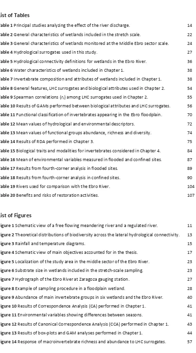
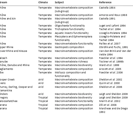
(28) General Introduction. Rhine and Elbe (Table 1). All of them are floodplains in temperate climates, so information about Mediterranean, arid and tropical systems is even scarcer.. Table 1 Principal studies analyzing the effect of the river discharge on aquatic invertebrates inhabiting wetlands aligned along the lateral hydrological connectivity. Stream. Climate. Subject. Reference. Rhône. Temperate. Castella 1984. Rhône Rhône and Ain. Temperate Temperate. Rhône Rhône Rhône Rhône. Temperate Temperate Temperate Temperate. Rhône Upper Rhine Lower Rhine and Meuse. Temperate Temperate Temperate. Macroinvertebrate composition (sub‐group) Macroinvertebrate composition Macroinvertebrate composition (sub‐group) Oligochaeta functionality Trichoptera functionality Aquatic insects functionality Plecoptera and Ephemeroptera functionality Macroinvertebrate functionality Gastropods composition Macroinvertebrate composition. Salzach Danube Rhône, Danube and Rhine Tagliamento Elbe. Temperate Temperate Temperate Temperate Temperate. Cooper Creek Ovens Murray, Darling, Cooper and Diamantina Flinders Gregory Caloosahatchee Parana Parana. Arid Arid Arid. Macroinvertebrate composition Macroinvertebrate richness Macroinvertebrate biodiversity Macroinvertebrate composition Molluscs composition and functionality Macroinvertebrate composition Macroinvertebrate composition Macroinvertebrate composition. Arid Tropical Tropical Tropical Tropical. Macroinvertebrate biodiversity Macroinvertebrate biodiversity Macroinvertebrate functionality Macroinvertebrate composition Macroinvertebrate composition. Amoros and Roux 1988 Castella 1991 Juget and Lafont 1994 Tachet et al. 1994 Usseglio‐Polatera 1994 Usseglio‐Polatera and Tachet 1994 Paillex et al. 2007 Obrdlik and Fuchs, 1991 Van den Brink and Van der Velde 1994 Foeckler et al. 1994 Tockner et al. 1999b Ward et al. 1999 Arscott et al. 2005 Foeckler et al. 2006 Sheldon et al. 2002 Quinn et al. 2000 Sheldon et al. 2006 Leigh and Sheldon 2009 Leigh and Sheldon 2009 Merrit et al. 2002 Zilli et al. 2008 Marchese and de Drago 1992. Climatic differences between Mediterranean, temperate, arid and tropical systems (as shown in Figure 3) may influence hydrological patterns and thus, the response of aquatic communities. Mediterranean streams are characterized by high spatial and temporal heterogeneity that offers habitats for numerous rare or endemic species (Myers et al. 2000). These characteristics make Mediterranean streams an ecosystem of great ecological value, despite being confined to small regions of the world (between 1‐4% of the continental area, mostly located in the Mediterranean basin) (Gasith and Resh 1999). Moreover, the impact of river regulation is higher in Mediterranean than in other climatic areas because of its natural variability, higher vulnerability, and poorer 14.
(29) General Introduction. recovery capacity (Gasith and Resh 1999, Bonada et al. 2007). Consequently, there is an unmet need to integrate the study of rivers and their floodplains, particularly in Mediterranean regions. Such lack of information may be related to the lack of naturally fluctuating systems, since most of the European and North American floodplains have been regulated for centuries (Wantzen et al. 2008). This lack of knowledge is most remarkable as floodplain occupation and water diversion increases continuously, and all climate‐change models consistently predict increases in extreme climatic events, and reductions in water availability (Wantzen et al. 2008).. 40. 15. 30. 10. 20. 5. 10. 0. 0 Jan Feb Mar Apr May Jun. 50. 100. 40. 80. 30. 60. 20. 40. 10. 20. 0. Jul Aug Sep Oct Nov Dec. 0 Jan Feb Mar Apr May Jun Jul Aug Sep Oct Nov Dec. Tropical climate (Escuela artil, Argentina) 60. 25. 50. 20. 40. 15. 30. 10. 20. 5. 10. 0. 0 Jan Feb Mar Apr May Jun. Temperature (ºC). 30. Precipitation (mm). Temperature (ºC). Arid climate (Birdsville, Australia) 60. 120. 50. 100. 40. 80. 30. 60. 20. 40. 10. 20. 0. 0 Jan Feb Mar Apr May Jun. Jul Aug Sep Oct Nov Dec. Precipitation (mm). 20. Temperature (ºC). 50. Precipitation (mm). Temperature (ºC). 25. Precipitation (mm). Temperate climate (Venice, Italy). Mediterranean climate (Zaragoza, Spain). Jul Aug Sep Oct Nov Dec. Figure 3 Rainfall (blue) and temperature (red) diagrams corresponding to different climatic regions. The present study focused in a Mediterranean river. Data extracted from www.globalbioclimatics.org.. Concluding, although the investigation of hydrological gradients has become a major issue in river ecology, several questions remain to be answered. For instance, given the actual scenario of increased water demand and climate change, which would be the habitats and aquatic communities’ response to future changes in the hydrological regime? Are environmental gradients more or less important than hydrological connectivity in structuring habitats and aquatic communities, or do they have interacting effects on floodplain ecosystems? To what extent do human activities disrupt natural hydrological and environmental gradients? How does such disruption affect the distribution of species? Will a Mediterranean system be more or less drastically affected by human alteration and climate change than other climatic systems? The answers to these questions are not simple and require an integrating approach, but it is clear that the river‐floodplain linkages and their disruption by human activities need further research, especially for rivers undergoing deep transformations due to climate change, river regulation or ecological restoration. 15.
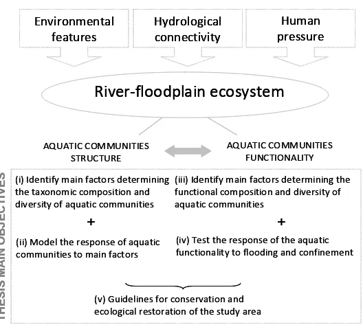
(30) General Introduction. Objectives Taking into account (a) the important ecological, social and economic value of the river‐floodplain ecosystem, (b) the key role of the interaction between hydrological connectivity, environmental gradients and human pressure in determining the structure, biodiversity and functionality of the ecosystem, (c) the strong reduction in natural gradients caused by flow diversion and regulation in the last decades, (d) the special vulnerability of Mediterranean rivers to reductions in flow quantity, quality and variability, and (e) the role of aquatic communities, specially macroinvertebrates, in the river‐floodplain environment, which makes them reliable indicators of higher‐scale processes, the main goal of the present thesis is: To provide a solid background for river‐floodplain restoration through the response of aquatic communities, especially macroinvertebrates, to changes in hydrological connectivity, environmental factors and human pressure across the lateral hydrological connectivity in a large Mediterranean river. This main goal will be accomplished by means of five specific objectives that cover both the taxonomic and functional aspects of aquatic communities, in an attempt to improve basic knowledge, but also to provide guidelines to management actors. These objectives are structured as follows (Fig. 4): Taxonomic approach: (i) To identify main hydrological and environmental factors determining the taxonomic composition and diversity of aquatic communities across the lateral hydrological connectivity. (ii) To model and predict the response of floodplain aquatic assemblages to the lateral hydrological connectivity. Functional approach: (iii) To identify main hydrological and environmental factors determining the functional composition and diversity of aquatic communities across the lateral hydrological connectivity. (iv) To test the response of the macroinvertebrate functional composition and biodiversity to flooding and confinement patterns.. 16.
(31) General Introduction. Management guidelines: (v) To use the available information (key factors influencing the composition, diversity and functionality of aquatic communities) to provide guidelines for the conservation and ecological restoration of the study area.. Environmental features. Human pressure. Hydrological connectivity. Figure 4 Schematic view of main objectives (i‐v) accounted for in this thesis.. River‐floodplain ecosystem. THESIS MAIN OBJECTIVES. AQUATIC COMMUNITIES STRUCTURE. AQUATIC COMMUNITIES FUNCTIONALITY. (i) Identify main factors determining (iii) Identify main factors determining the the taxonomic composition and functional composition and diversity of diversity of aquatic communities aquatic communities. + (ii) Model the response of aquatic communities to main factors. + (iv) Test the response of the aquatic functionality to flooding and confinement. (v) Guidelines for conservation and ecological restoration of the study area. Study Approach Following the scheme provided in Figure 4, Chapter 1 aimed to investigate the key hydrological and environmental factors determining the presence and abundance of macroinvertebrates in the Middle Ebro floodplain. To this end, wetlands were identified by their hydrological connectivity with the main river channel and it was hypothesized that the macroinvertebrate assemblages of those wetlands, quantified through diversity and abundance measurements, would show significant differences. Invertebrate attributes (such as abundance, richness, diversity and evenness) at wetlands arranged in a lateral hydrological connectivity were further investigated to test the Intermediate Disturbance Hypothesis (Connell 1928). Chapter 1 has been published with modifications in Aquatic Sciences (70: 248‐258). Once the key role of hydrological connectivity was proved in general terms for macroinvertebrate assemblages in Chapter 1, we tested the ability of six different surrogates of hydrological connectivity (e.g., flood duration, magnitude and frequency) to model patterns of biological features (such as richness, abundance and composition), considering several aquatic groups. The simultaneous study of macroinvertebrates, zooplankton and phytoplankton provided an indication of 17.
(32) General Introduction. the effect of hydrological connectivity on the aquatic food web. Through this analysis, we aimed to select those hydrological surrogates that best accounted for variability in aquatic assemblages features and that will be useful for planning and executing restoration in the study area. This objective was accounted for in Chapter 2, which has been accepted for publication in Marine and Freshwater Research. After the taxonomic approach to the Middle Ebro floodplain was fully accomplished, we focused on the relationships between environmental variables and aquatic community functionality using invertebrate biological traits (e.g., respiration, reproduction or feeding behaviour) in Chapter 3. Our first objective was to identify significant differences in trait composition, trait richness and trait diversity between wetlands aligned along the lateral hydrological connectivity. As the taxonomic and functional compositions of invertebrates are usually considered to be shaped by the same environmental gradients, we hypothesized that key gradients extracted in Chapter 1 will exert a significant influence in the relative abundance of functional traits. This chapter has been published in Fundamental and Applied Limnology (173: 281‐292). Similarly, in Chapter 4 we aimed to investigate the relative importance of environmental features related to flooding and confinement to explain the macroinvertebrate trait composition in the Ebro floodplain wetlands. To this end, we used data from a higher geographical scale sampling (Middle Ebro sector scale) that allowed us to test the simultaneous relationships of environmental variables, species abundance and species traits through an improved statistical procedure, the fourth‐corner analysis (Dray and Legendre 2008). Differences in trait composition and biodiversity between flooded and confined sites were also assessed. Chapter 4 has been accepted for publication in Journal of Limnology. Finally, the General Discussion section tried to gather the solid understanding provided in Chapters 1‐4 to (i) summarize findings about aquatic community patterns across hydrological and environmental gradients in the Middle Ebro floodplain, (ii) discuss these findings in the framework of other temperate, tropical and arid streams, (iii) examine how this information can be used to provide guidance for restoration projects in the area of study.. 18.
(33) General Methodology.
(34) 20.
(35) General Methodology. General Methodology Study Area The area of study was located in the middle sector of the Ebro River, in NE Spain. With a catchment area of 8,093 km2 and a length of 910 km, the Ebro is a large Mediterranean river and the longest river in Spain. In its middle sector, near the city of Zaragoza, the Ebro is a meandering river (sinuosity = 1.39, slope = 0.05%) with an average 5‐km width floodplain. At Zaragoza gauging station, average discharge is 230 m3s‐1 (Spanish Water Authority, URL: http//: www.chebro.es). The Ebro River environmental problems are similar to those faced by other rivers in Europe and North America. In the past 150 years, humans have canalized, polluted, and impounded this river for agricultural, urban, and industrial purposes. In the last century, and more intensively since the 60’s, the floodplain of the Ebro River have been extensively affected by changes in land‐use and construction of structures to control flood (Cabezas 2008). The combination of disturbance pulses and natural river succession in the Ebro river‐floodplain has historically created numerous wetlands that have varying degrees of hydrological connection as, for example, secondary channels, backwaters, oxbow lakes, and temporary pools (Ollero 1996). However, the lack of intensive, erosive floods in the last decades has reduced the probability of creation of new wetlands. Consequently, most of the floodplain area (more than 60%) is used for agriculture whereas wetlands cover only 3.6% of it (Cabezas et al. 2008).. Sampling scales We performed several samplings during the years 2006 and 2007, with different frequencies (bi‐ monthly and annual) and spatial scales (stretch and sector), depending on the particular objectives of the study. Stretch‐scale— The sampling performed in 2006 every two months (6 times) included four natural oxbow lakes (NOL), two constructed oxbow lakes (COL) and the main river channel (RS), all of them located within Natural Reserve Areas (Table 2 and Fig. 5). The stretch‐scale sampling covered a 13‐km of the river catchment. The study sites were located within natural reserve areas and represented the widest range of hydrological connectivity within the river floodplain system, from permanently flooded (RS) to rarely flooded (NOL) or seepage‐flooded (COL) wetlands. This sampling was intended to provide intensive and detailed multivariate information on a set of 6 wetlands and the Ebro River. Sampling included water chemistry and macroinvertebrate communities, and resulting information was used in Chapters 1‐3. In addition, variations in the water‐column and plankton (zooplankton and 21.
(36) General Methodology. phytoplankton) communities were monitored in three of these wetlands (NOL1‐3) to further assess the effect of hydrological connectivity on the aquatic food web.. Table 2 General characteristics of wetlands included in the stretch‐scale. Depth is measured at the deepest part of the wetlands in summer. Wetland. Depth (m). Age (yr)A. Area (ha)B. River Dist (m)C. Urban Dist (m)C. Substrate. Vegetation cover. Hydrological connectivity. RS2. ‐. ‐. 125.5. 0. 1520. Gravel. Permanently. NOL1 NOL2 NOL3 NOL4. 0.8 1.73 2.42 0‐1.10. 42 61 61 61. 70.31 35.45 10.33 4.82. 1077 868 833 269. 4141 2418 3066 1704. Silt Silt / Clay Silt Silt / Clay. COL1. 0.5. 2. 3.07. 518. 3133. Gravel. COL2. 0.5. 1. 2.08. 528. 2817. Gravel. Emergent/ Submergent Emergent Emergent Emergent Emergent/ Herbaceous Emergent/ Submergent None. Frequently Intermediate Rarely Rarely Seepage Seepage. A. Age is the time since the cut‐off of oxbow lakes, or construction, depending on origin. B Area was measured using summer aerial photographs. C River and urban distances are the minimum distance from each wetland to the river channel or the nearest urban area.. The Ebro River was representative of the highest level of hydrological connectivity and was the main source of water, organisms, and energy through flow and flood pulses to riparian wetlands. One sampling station was established in the river channel at the centre of the study area. Although the point selected in the river channel was located 500 m downstream from the Zaragoza wastewater treatment plant, the environmental conditions of this site are not significantly different from other sites in the river channel (personal observation), which are characterized by high nutrient loads. As reported by Torrecilla et al (2005), agricultural, industrial and urban development in the Ebro basin has a significant impact on its water quality, particularly on the nitrate concentration that is high in its middle sector (between 10 and 30 mg L‐1). In addition, other authors have observed the effect of waste plants on the benthic community to diminish 300 m downstream (Ortiz and Puig 2005). NOLs showed similar habitat characteristics in terms of morphology, vegetation and substrate texture. They were small (35–70 ha) and shallow (0.5–2 m of depth) former river meanders, 42 to 61 years old, that were separated from the river channel by a strip of riparian vegetation and a thick layer of sediment limiting groundwater seepage. Substrate size was similar in NOLs and COLs, with 70‐90% of fine and sand materials (particles < 500 µm), which contrasted with the high percentage of coarse materials (90% particles > 500 µm) in RS (Fig. 6). NOLs were surrounded by emergent vegetation, mostly Phragmites australis and Typha latifolia, but lacked submergent vegetation. They. 22.
(37) General Methodology. were flooded at different flow limits (from 400 to 1200 m3s‐1) depending on distance to the river and channel embankment, and were thus arranged in a gradient of lateral hydrological connectivity.. Figure 5 Localization of the study area in the middle sector of the Ebro River. RS= River sites, SC= secondary channels, BW= backwaters, NOL= natural oxbow lakes, COL= constructed oxbow lakes. Scale bar is for every enlarged area, except for COL1 and COL2 that present a different scale. Black dots are sampling points were water and macroinvertebrate samples were taken. Every wetland was included in the Middle Ebro‐scale sampling. Wetlands in the blue enlarged areas were also included in the stretch‐scale samplings. Distance from Boquiñeni to Sástago is 100 km approximately.. Substrate size (%) 100%. Figure 6 Substrate size as percentage of particles showing different sizes (in µm) in wetlands included in the stretch‐scale sampling.. 80% >500. 60%. 63‐500 <63. 40% 20%. COL2. COL1. NOL4. NOL3. NOL2. NOL1. RS. 0%. 23.
(38) General Methodology. Both COL1 and COL2, which were constructed close to NOL3 to mitigate wetland loss, have gravel substrata that allow water seepage from the river and hill‐slope aquifers. However, their relatively high elevation does not allow for a surface connection with the river at flows below 2500 m3s‐1, which has probably contributed to the lack of fish in these systems. Aquatic vegetation has rapidly colonized COL1 (Typha latifolia and submerged macrophytes), but COL2 remains un‐vegetated. Middle Ebro sector scale— A higher scale sampling was performed with an annual frequency in 2006 and 2007 (twice), including 17 wetlands that covered a 100‐km long stretch of the river catchment. This sampling was intended to complement the stretch‐scale sampling by increasing three fold the number of sampling points, thus increasing the accounted spatial variability and leading to reliable results. At this larger geographical scale, variables related to water chemistry and macroinvertebrate communities were used. Sampling sites included three stations located at the river channel (RS), four side channels (SC), four backwaters (BW), four natural oxbow lakes (NOL) and three constructed oxbow lakes (COL) (Fig. 5, Table 3).. Table 3 General characteristics of wetlands monitored at the Middle Ebro sector‐scale. Wetland. XA. YA. Vegetation. Substrate. Area (ha)B. Human alteration. River DistC. Urban DistC. RS 1. 646357. 4635935. 1573. 463572. ‐. Agriculture / Natural Agriculture. 0. 647186. 0. 2054. RS 3. 686790. 4605968. ‐. Agriculture. 0. 1520. SC 1. 646869. 4635188. Gravel / Silt Gravel / Silt Gravel / Silt Gravel. ‐. RS 2. 2.22. Agriculture. 138. 1535. SC 2. 722320. 4577914. Gravel. 7.5. 250. 668249 684208. 4621761 4608171. Gravel Sand. 2.09 0.23. 162 75. 1708 2528. BW 1 BW 2. 697289 694396. 4603333 4602628. Emergent Herbaceous. Silt / Clay Gravel. 1.74 2.1. 64 103. 4506 4967. BW 3. 664268. 4623910. Herbaceous. Gravel. 2.45. 215. 1216. BW 4. 689689. 4604661. ‐. Gravel. 0.94. 32. 1075. NOL 1. 672608. 4619264. Emergent. Silt. 70.31. 923. 3836. NOL 2. 686752. 4608237. Emergent. Silt / Clay. 35.45. 868. 2418. NOL 3. 684438. 4606963. Emergent. Silt. 10.33. 833. 3066. NOL 4. 686499. 4605879. Emergent. Silt. 4.82. Agriculture/ Industrial Agriculture Agriculture / Natural/ Urban Agriculture Agriculture / Impoundment Industrial/ Impoundment Agriculture / Industrial Agriculture/ Natural Agriculture/ Natural Agriculture/ Natural Agriculture/ Urban. 215. SC 3 SC 4. Emergent/ Submergent Emergent/ Submergent Emergent/ Submergent Emergent/ Submergent Emergent/ Submergent Submergent Herbaceous. 269. 1704. 24.
(39) General Methodology. COL 1. 684595. 4607221. Gravel/ Silt Gravel. 0.25. 4607559. Emergent/ Submergent ‐. COL 2. 684412. COL 3. 688219. 4606339. Emergent. Gravel/ Silt. 4.86. 0.58. Agriculture/ Natural Agriculture/ Natural Agriculture/ Fish. 546. 3086. 528. 2817. 344. 1038. A. UTM geographical coordinates are referred to the North hemisphere, zone 30. Area was measured using summer aerial photographs. C River and urban distances are the minimum distance (m) from each wetland to the river channel or the nearest urban area. B. Similar to the sampling performed at the stretch‐scale, RS provided the reference for river conditions in terms of hydrological connectivity, water chemistry or invertebrate composition. The number of sampling points in the river channel increased from one at the stretch‐scale, to three sampling points (Fig. 5) at the Middle Ebro sector‐scale. Although SCs showed lower water current than the main river channel, they were permanently connected at their upstream and downstream ends with the river channel. SCs were surrounded by riparian vegetation, and showed emergent and submerged vegetation. Substrata in SCs were mainly composed of gravels and sand. BWs were surrounded by emergent vegetation and presented a fine sediment substratum due to high sediment inputs from the river. BWs were connected to the main channel at their downstream end, but were reconnected at their upstream end at intermediate river discharge (200‐400 m3s‐1). Some of them (e.g., BW2) were close to industrial parks or waste water treatment plants (e.g., BW5). The natural oxbow lakes sampled at the Middle Ebro sector‐scale were the same as those sampled in the stretch‐scale. Three COLs were monitored at the Middle Ebro sector‐scale. Two of them (COL1 and COL2) are the same described in the stretch‐scale. COL3 was an older constructed lake for gravel extraction and actually used for sport (fishing) purposes. Consistently with COL1 and COL2, COL3 had gravel substrata and was surrounded by emergent vegetation. In contrast, COL3 was bigger, deeper and was flooded with higher frequency than COL1 and COL2.. Hydrological setting Even though the Ebro floodplain has been hydrologically disconnected from the main river, the flow in the middle section is relatively variable, and conserves its dynamism. In fact, overbank floods (i.e. those exceeding the floodplain level, established at 600 m3 s‐1) occur on average 33 days per year, while river discharge is at its lowest (< 30 m3s‐1) during summer, which occurs on average 47 days. 25.
(40) General Methodology. every year (mean values from 1980‐2006, discharge data from the Spanish Water Authority, URL: http//: www.chebro.es). Between 12 and 16 March 2006, an extraordinary flood (1,586 m3s‐1, 2‐yr return period, Fig. 7) raised the floodplain water level to a point where all of the floodplain wetlands, except COLs, were connected to the river. Excluding this flood event, the river flow remained unusually low in 2006 (average discharge in 2006= 143 m3s‐1; average discharge from 1912 to 2003= 235 m3s‐1, Fig. 7). Another extraordinary flood took place between 25 March and 16 April 2007 (2,282 m3s‐1, 10‐yr return period, Fig. 7). Photographs from this flood episode can be consulted in Appendix 5. In contrast to the dry 2006, 2007 can be considered closer to the average conditions (average discharge= 228 m3s‐1). By the time we performed the sampling, the wetlands could be considered to be fully recovered from flood events. Nevertheless, the wetland connectivity caused by the 2006 and 2007 floods provided an opportunity to assess wetland response to surface connection gradients across the floodplain.. Figure 7 Hydrograph of the Ebro River at Zaragoza gauging station between January 2006 and July 2007.. 2000. 3. River discharge (m /s). 2500. 1500 1000 500. 6 Ja n‐ 07 M ar ‐0 7 M ay ‐0 7. 06. v‐ 0 No. Se p‐. l‐0 6 Ju. Ja n‐ 06 M ar ‐0 6 M ay ‐0 6. 0. Beyond river flow discharge, water‐level in each NOL was recorded continuously using pressure‐ based meters with 1‐cm resolution (DI‐241 Diver, Van Essen Instruments®). One data logger was located at the center of each NOL, so that the same value of water‐level was assigned to the three sampling points located within each NOL. Several surrogates of hydrological connectivity were calculated from water‐level data provided by data‐loggers and aerial photographs, which are summarized in Table 4.. 26.
(41) General Methodology. Table 4 Hydrological features used to study the effect of hydrological connectivity on floodplain aquatic communities. Hydrological feature*. Abbreviation. Units. Description. River Distance. RD. m. Flood Limit Flood Magnitude. FL FM. m3s‐1 %. Flood Duration. FD. days. Flood Frequency. FF. nº. Minimum distance from each sampling point to the river channel River flow limit to overbank flood Increase in water‐level relative to the minimum water‐level in the study period Number of days/yr that the river flow rose above the flood limit Number of events/yr that the river flow rose above the flood limit Coefficient of variation of the water‐level over a period of 7 days before each sampling date in each wetland As above but in a 30 days period. Water level variability WLV 7 ‐ 7 days Water level variability WLV 30 ‐ 30 days ‐ As above but in a 180 days period Water level variability WLV 180 180 days Water level variability WLV 365 ‐ As above but in a 365 days period 365 days * To note that hydrological features were only available for NOL1‐3 monitored at the stretch‐scale, and not for other wetlands included in the stretch‐ or Middle Ebro sector‐scales.. Sampling procedure Two to three sampling points depending on the area (see sampling points in Fig. 6) were located in each wetland, and one sampling point in the river channel, for environmental and biological monitoring. Sampling was similar at both scales, thus only the number of wetlands monitored and the sampling frequency varied. An example of sampling procedure (samples and variables measured) in a floodplain wetland is shown in Figure 8. The general procedure is described below and the specific methodologies (e.g., supplementary variables, statistical analyses) are described in each chapter.. Figure 8 Example of sampling procedure in a floodplain wetland. In each sampling point (black dots) physic‐chemical variables were measured in situ, a water sample was taken to the laboratory for chemical analyses, and three macroinvertebrate samples were collected at different habitats.. 27.
(42) General Methodology. Environmental monitoring At each sampling point, dissolved oxygen, temperature, conductivity and pH were measured in situ using portable probes previously calibrated (WTW® Multiline P4). Two‐litre water samples were collected directly into acid‐washed polycarbonate bottles at a depth of 20 cm and placed on ice. On the same day, samples were filtered through Whatman® GF/F glass fibre filters (pre‐combusted at 450ºC for 4 h) to determine the amount of suspended, dissolved and ash‐free solids (APHA 1989). Alkalinity was measured using potentiometric automatic titration with 0.04 N H2SO4 (APHA 1989). Ion chromatography was used to determine dissolved nutrient and anion concentrations (Br‐, Cl‐, SO42‐, F‐ , NO3‐, NO2‐, PO43‐, K+, Mg2+, Na+ and NH4+) and a continuous flow analyzer (FLOWSYS‐SYSTEA®) was used to determine total nitrogen (TN) and total reactive phosphorous (TP) (APHA 1989). Organic fractions (DON and DOP) were calculated as the difference between totals (TN, TP) and inorganic fractions (DIN, DIP) respectively. Finally, phytoplankton photosynthetic pigments were analyzed using the Spectrophotometric Method (APHA 1989). Results from these analyses can be consulted in Appendix 1.. Biological sampling and identification A sweep net (45 x 45 cm frame net, 500 µm sieve, 1 min. sampling) was used to collect invertebrates (catches per unit effort, CPUE) at various microhabitats within each wetland. The microhabitats included emergent vegetation (e.g., Phragmites australis and Typha latifolia, which were present in dense stands along the margins of most floodplain wetlands), leaf packs (coarse organic matter), riverbank areas that were free of vegetation and had a silt or gravel substratum, and stagnant waters. Samples were preserved in 5% formalin and then washed through nested sieves (2500 µm, 1000 µm, and 500 µm). Samples were hand‐sorted under a stereoscopic microscope, and organisms were identified to the lowest taxonomic level, usually genus. The results from different habitats sampled in each sampling point were pooled together. A taxa list of benthic macroinvertebrates found in different habitats (e.g., RS, SC, BW) of the Ebro ecosystem can be found in Appendix 2.. Statistical analyses Given the high amount of data gathered, special attention has been devoted to the statistical analysis of the hydrological, environmental and biological data sets. To extract significant patterns, traditional statistics (such as multivariate analysis or regression models) and modern applied statistics (such as complex regression models or the fourth‐corner method) have been used in combination. To that 28.
(43) General Methodology. end, several statistical software programs were used, such as SPSS 15.0, CANOCO 4.5 and R 2.5.1. The latter, R 2.5.1, has been increasingly used because of its wide flexibility and applications, and the statistical functions used in each chapter are listed in Appendix 4. Because of their complexity, the specific statistical analyses will be described in each chapter.. 29.
(44) 30.
(45) Results. 31.
(46) 32.
(47) Results. Chapter 1 Main environmental factors determining the taxonomic composition and diversity of aquatic communities across the lateral hydrological connectivity 1. Abstract Flood and flow pulses are primary factors that regulate macroinvertebrate community structure in river‐floodplain ecosystems. In order to assess the impacts of these important hydrological events in a regulated Mediterranean river, bimonthly water and macroinvertebrate samples were collected in 2006 in the Ebro River and six floodplain wetlands. We found significant differences among the river sites (permanently flooded), two constructed wetlands (seepage flooded) and three natural oxbow lakes (surface flooded at 400, 800 and 1200 m3s‐1). River sites were dominated by aquatic worms (e.g., Naididae) and showed a high degree of eutrophication. Constructed wetlands provided new habitat for predatory insects (e.g., Coenagrion scitulum and Trithemis annulata) that benefited from the absence of fish. Natural oxbow lakes were dominated by crustaceans (e.g., Atyaephyra desmaresti, Procambarus clarkii) and were highly overlapped in Correspondence Analysis. Canonical Correspondence Analysis, coupled with variance partitioning, showed that hydrological connectivity accounted for 28% of the variability in the invertebrate community, followed by physic‐chemical (10%) and trophic (7%) factors. Differences in frequency and duration of flood pulses in natural oxbow lakes were not enough to generate distinctive macroinvertebrate assemblages in the different wetlands. In contrast, richness and total abundance increased with hydrological connectivity, while diversity showed a rather unimodal distribution, consistent with the Intermediate Disturbance Hypothesis. Generalized Additive Models indicated that among the measured environmental variables, nitrate strongly affected the abundance, diversity and evenness of aquatic communities. Our data highlight that increasing the diversity of waterbody types in degraded floodplains enhances biodiversity and aids in the functional recovery of the river landscape.. Introduction The structure and function of river‐floodplain ecosystems are directly, and indirectly, affected by river discharge fluctuations (sensu “flood” and “flow pulses”, Junk 1989, Tockner et al. 2000). Hydrological connectivity involves patterns and processes across the river‐floodplain system, such as transport of suspended or dissolved elements and organisms, reorganization of habitats, productivity and biodiversity of aquatic and terrestrial communities (Amoros and Roux 1988, Ward and Stanford 1995, Tockner et al. 1999a). Several factors beyond river flow fluctuations can influence floodplain. 1. This chapter has been published with modifications as follows: Gallardo, B., M. García, A. Cabezas, E. González, M. González, C. Ciancarelli and F. A. Comín. 2008. Macroinvertebrate patterns along environmental gradients and hydrological connectivity within a regulated river‐floodplain. Aquatic Sciences 70: 248‐258. 33.
(48) Results. hydrological connectivity. The distance from the river to the wetlands is directly related to overbank flood frequency wherever there are no natural or artificial barriers to water flow. The morphology of the upstream and downstream wetland borders is related to the magnitude and duration of surface connectivity with the main channel (Amoros and Bornette 2002). Groundwater seepage, which also makes significant contributions to wetland water levels, is limited by subsurface geological materials and sediment accumulation. The combination of these features results in a shifting mosaic of aquatic and terrestrial patches that provides highly diverse aquatic habitats, communities and processes within the river‐floodplain system (Ward 1998). Given that higher habitat diversity will promote increased biological diversity, aquatic assemblages (from phytoplankton to fish) provide an adequate measure of habitat structure and function at different spatial and temporal scales, and are often used to assess hydrological patterns (Rosenberg and Resh 1993). Among freshwater organisms, invertebrates are particularly useful because of their short life cycles and multiple adaptation strategies (e.g., body form, cycles per year, life span, feeding habitats) to environmental gradients (Gasith and Resh 1999). Since many benthic invertebrates exhibit a sessile life style, their presence can be particularly telling about habitat quality. Moreover, specific groups of macroinvertebrates show overlapping optima of abundance and diversity along both spatial and environmental gradients, although little is known about them (e.g., Tockner et al. 1999b, Arscott et al. 2005). In this study, we investigated the relationships between physical, chemical and biological characteristics of floodplain wetlands in the middle sector of the Ebro River (NE Spain). We identified wetlands by their hydrological connectivity with the main river channel and hypothesized that the macroinvertebrate assemblages of those wetlands, quantified through diversity and abundance measurements, would demonstrate significant differences. We also identified multiple environmental gradients that affect aquatic communities and, by partitioning the variability of those gradients, we were able to test their separate importance in explaining invertebrate community variability. We further investigated differences in invertebrate attributes (e.g., abundance, richness, diversity and evenness) between wetlands arranged along a lateral hydrological connectivity and hypothesized that according to the Intermediate Disturbance Hypothesis (Connell 1978), diversity will increase at intermediate levels of hydrological disturbance. In addition, we modeled the response of invertebrate attributes against a gradient of nitrate concentration, which reflects agricultural land‐use in the Ebro catchment, an activity that occupies more than the 60% of the catchment (Ollero 1996). Finally, we addressed the effect of wetland creation at the scale of the floodplain and discuss the implication of our results for river‐floodplain conservation and restoration.. 34.
Figure

+7


Documento similar
[7]. This problem has acquired great relevance in Mediterranean rural landscapes. Land uses and ecosystem services, associated with their millenarian landscapes, have been drastically
This effect may be related to an increase in particle collision (homoaggregation and het- eroaggregation) due to stirring in combination with resuspension of the sediment by
Indeed, the variations in all traits related to burrow construction and soil and dung manipulation play a key role in the most important effects of dung beetles on
For a short explanation of why the committee made these recommendations and how they might affect practice, see the rationale and impact section on identifying children and young
The expansionary monetary policy measures have had a negative impact on net interest margins both via the reduction in interest rates and –less powerfully- the flattening of the
Jointly estimate this entry game with several outcome equations (fees/rates, credit limits) for bank accounts, credit cards and lines of credit. Use simulation methods to
In our sample, 2890 deals were issued by less reputable underwriters (i.e. a weighted syndication underwriting reputation share below the share of the 7 th largest underwriter
The current study discusses initiatives to achieve environmental sustainability in manufacturing processes, and focuses in particular on the application of the environmental
