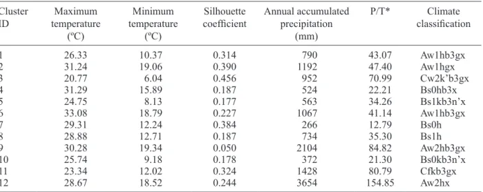
Climatic analysis linked to land vegetation cover of Mexico by applying multivariate statistical and clustering analysis
Texto completo
Figure


Documento similar
Figure 41: Phase’s space diagram for a test at an angular velocity of 19.36 rpmm Figure 42 shows phase’s plane diagram corresponding to a test at an angular velocity of 14.86
The “∪ chains” column gives the total number of ad resources identified by applying the request chain approach (Section 3.4) to images and frames identified as advertisements by
In this study, we updated a global meta-analysis on the effects of inter-row extensive vegetation cover management, particularly through the use of cover crops, on ecosystem
In brief, the clustering de nition XML le contains the description of four elements of the clustering process: the parameters associated to each CPU burst in the trace used by
Looking ahead a few decades, land suitable for agriculture will likely continue to diminish as urban areas expand, soil is degraded, fertile soil is washed down rivers and blown
A SSD group obtained without using any a priori definition, by means of cluster analysis of delirium symptoms measured by the DRS-R98 in 859 international
pinaster forests, (2) to determine the geographical patterns of growth responses to drought and climate, and (3) to assess if climatic variables (temperature and precipitation),
Cluster analysis Factor analysis Heckit model (Probit) Heckit model (OLS) Ln (Number of introduced species known) Cluster analysis. Factor analysis EXOTIC_KNOWN Ordinal Square
