For reasons of economy, this document is printed in a limited number, and will not be distributed at the meeting. Delegates are requested to bring their copies to the meeting and not to request additional copies.
“
Wetlands and water: supporting life, sustaining
livelihoods”
Kampala, Uganda, 8-15 November 2005
Ramsar COP9 DOC 22
[English only]
Enhancing the information on Wetlands of International
Importance (Ramsar sites): the role of the Ramsar Sites
Information Service
Note by the Secretariat
1. The attached progress report has been prepared by Doug Taylor of Wetlands International under
the terms of WI’s 2003-2005 contract with the Ramsar Secretariat to maintain the ‘Ramsar Sites Database’.
2. The report outlines the substantial developments which have taken place during this triennium to
make the Ramsar Sites Database and supporting service more valuable and accessible, in particular in providing online Web access to the increasing suite of data and information available on designated Ramsar sites, including the searchable Ramsar Sites Database and copies of full Information Sheets on Ramsar Wetlands (RIS) and maps. Access to this information is now being developed through an interactive map-based system, as well as through other search methods. In view of this expansion of the services available, such that the system is now much more than just a database, the service has now been retitled as the ‘Ramsar Sites Information Service’ to reflect its wider scope. The service is available on line on: http://www.wetlands.org/RSDB/Default.htm
3. A number of these developments, including the implementation of the wetland inventory
meta-database called for in Resolution VIII.6 and the ‘Web-mapper’, have been made possible through additional funding acquired for the implementation of related projects which support Ramsar Convention implementation. These include the European Space Agency (ESA) “GlobWetland” project, which is developing remote sensing tools and information for wetland managers on 50 Ramsar sites worldwide. The GlobWetland project is a follow-up to the ESA’s successful TESEO project designed to support Convention implementation, which was reported to COP8.
4. The report also outlines a number of suggested future directions for further development, notably
5. The report also recommends that the preparation of the “Ramsar Sites Directory” should be discontinued. This aspect of the work takes up a considerable proportion of the staff time and funding under the contract. However, its original purpose and utility (providing a standard summary statement for each Ramsar site) has now become much less important owing to this information now becoming much more consistently available through the use of the RIS, in combination with the summary information provided in the Ramsar sites “Annotated List”. Dropping this aspect of the current work would allow for greater flexibility in pursuing the more innovative developments expected under current (unfunded) Objective 3, and in enhancing the suite of data and information accessible for each Ramsar site.
Enhancing the information on Wetlands of International
Importance (Ramsar sites): the role of the Ramsar Sites
Information Service
1. Introduction and Background
1. The Ramsar Convention on Wetlands has, since its inception, been a very practical international agreement. This is because, in order to discharge its purpose of creating a network of internationally important wetlands and safeguarding migrant populations of waterbirds, sites are designated by a Contracting Party and recorded in the List of Wetlands of International Importance, and managed within a global network to the best ability of the Contracting Party responsible for the site. Sites are designated in order to contribute towards the Vision for the List:
“To develop and maintain an international network of wetlands which are important for the conservation of global biological diversity and for sustaining human life through the ecological and hydrological functions they perform” (taken from Resolution VII.11).
2. Over the years since the Convention was established, essential tools for describing wetlands and for establishing quality criteria for designation have been developed and are now well established. Because it is a practical agreement, factual information about wetlands, wetland species and their management have been collected over many years by the management authorities responsible for the Ramsar sites.
3. The Information Sheet on Ramsar Wetlands (RIS) is completed and supplied to the Ramsar Secretariat when a Ramsar site is designated by a Contracting Party. The RIS (and its accompanying guidance) was developed by Wetlands International and its founding organizations to enable the standardised collection and exchange of information about sites from Contracting Parties, according to the criteria established for designation.
4. The RIS is the main organizing tool to support the List of Wetlands of International Importance, for it holds the essential information about a site, including basic information about ecological status. The RIS for each site and a map describing the boundary of the site are held by the Ramsar Secretariat, which also maintains the List.
5. One of the organizations that later formed Wetlands International, the International Waterfowl and Wetlands Research Bureau (IWRB), which had been providing support to the Convention since its adoption, produced the first Directory of Wetlands of International Importance in 1987 for participants at COP3 (Regina, Canada). Since then six further editions have been published and for COP9 a eighth edition is scheduled. IWRB, under successive MoUs with IUCN, was formally responsible for key data support services to the Ramsar Bureau.
6. The outposted Ramsar Liaison Officer developed the Ramsar Sites Database from 1990 onwards to act as a searchable metadata index to the content of the RISs. The database permits the Secretariat to monitor, assess and report to Parties on the progress in developing the Ramsar List towards the ‘comprehensive and coherent national and international network of Ramsar sites’ called for in the Strategic Framework and Guidelines for the future development of the List of Wetlands of International Importance (Resolution VII.11), as well as providing an request service to all those seeking information on Ramsar sites.
7. These two information services, the Directory and the Database, have remained as essential foundations for the work of the Convention to the present day.
8. The Ramsar Bureau (now Secretariat) since 1996 has developed an abbreviated form of the Directory called the Annotated List, which is now maintained through the Ramsar
Secretariat’s Web site and in a frequently-updated printed volume, and this information also provides the basis for announcements of new site designation on the “What’s New” section of the Ramsar Web site. Both the Directory and the Annotated List are based upon information provided in the RIS.
8. Since 1999, Wetlands International has maintained the Directory of Wetlands of International Importance in electronic form (CD-ROM and Internet), enabling open access to the detailed site descriptions.
10. Subsequently, in 2003, Wetlands International transferred the content of the Ramsar Sites Database from a closed system, previously accessible only to staff, to an open access web-searchable information service. This has dramatically changed the way the information services of the Convention are delivered, enabling users, including Ramsar Secretariat staff, to have rapid access to site information in the form and style that they desire.
11. Ramsar Sites Information Service. The information services and products on Ramsar sites currently available to Parties and others through the Convention include the following:
• List of Wetlands of International Importance (the List)
• Annotated Ramsar List
• (maintain) Information Sheet on Ramsar Wetlands (RIS)
• Directory of Wetlands of International Importance
• Ramsar Sites Database
• Web Mapper
1.2 The Cost/benefit of the service arrangements for Ramsar sites between Wetlands International and the Ramsar Secretariat
Service contract
12. The Ramsar Convention Secretariat and Wetlands International have a long-standing relationship based on technical partnership. Wetlands International is one of the
International Organization Partners of the Convention and the six-year Memorandum of Cooperation (November 2004) commits Wetlands International to support the Ramsar Strategic Plan. This MoC, and its predecessor Memorandum of Agreement (MoA) of 1997, recognises the effectiveness of the strategic partnership, based on the competencies of Wetlands International, to deliver against the Strategic Plan targets.
13. Since the foundation of the Convention, Wetlands International and its founding organization, IWRB, have supported the Convention technically, and in doing so, have enabled the Ramsar Secretariat to perform its work, while adding value to the resources of the Convention. This has been demonstrated in past cost/benefit analysis evidence supplied to the Conference of the Parties (Standing Committee Subgroup on COP8, May 2002).
14. Presently, Wetlands International is contracted by the Ramsar Secretariat to provide the “Ramsar Sites Database Service” to the Secretariat for the period 2003-2005. The Objectives and Actions for the Service are detailed in Annex 1. The three top level Objectives are:
Objective 1: to maintain the Ramsar site information and database and seek to improve the quality of data held.
Objective 2: to provide specific information products from the Ramsar Sites Database and facilitate analysis and application of the information.
Objective 3: to provide advice for implementation of the Strategic Framework for the future development of the List of Wetlands of International Importance.
15. The overall cost to the Convention of providing the Ramsar Information Service is
effectively subsidised by Wetlands International over the triennium 2003-2005 (and in past triennia) because the budget available from Convention funds is below the economic cost of providing the Service, especially for Objective 3, which is regarded as unfunded.
16. However, in recognition of many years of accumulated deficit-based funding, COP8 agreed to increase the annual increment over the triennium, so that in the final year of 2005, the cost of providing the Service was, in 2005 - for Objectives 1 and 2 and for the first time - met in full.
17. Recently, the Convention has also gained, at no additional cost to the finances of the Convention and Secretariat, a powerful Internet-based wetland inventory meta-database which was designed to fully conform to the intention of Resolution VIII.6, as requested in its paragraphs 19 and 20:
19. ALSO CALLS UPON all Contracting Parties and others who have undertaken, or are undertaking, wetland inventory to document information about the inventory, its data holdings, management and availability using the standard metadata record provided in the Framework for Wetland Inventory, so as to make this information available as widely as possible;
the standard metadata record for wetland inventory on the World Wide Web so that Contracting Parties and others can report and make fully available the information about their wetland inventories, and so as to assist in the updating by Wetlands International of global information about the status of wetland inventory;
18. This meta-database was developed by Wetlands International through the European Space Agency funded “GlobWetland Project”, which is providing over two years a series of space imaging products to 17 countries at 50 Ramsar sites (see www.globwetland.org).
19. In addition to the meta-database (which is also a core tool for the GlobWetland
Information Service), a powerful Web Mapper capable of hosting high resolution maps and satellite images was also developed at no cost to the Convention.
20. These two developments deliver two key advantages for enhanced functioning of the Convention’s Ramsar Sites Information Service:
i) A Ramsar Convention-adapted GlobWetland meta-database is now running as the main tool to relate all available information for sites, or at country, regional or global levels together.
ii) The Web Mapper now hosts the available Ramsar site maps, Ramsar site digital boundaries (where these have been supplied by Parties) and, for at least the Ramsar sites within the GlobWetland Project, many additional satellite-based products.
21. Technical information about the GlobWetland meta-database and the Web Mapper are provided in Annexes 2 and 3.
2. Ramsar Sites Information Service and Convention needs
22. This section reviews the current services provided within the Ramsar Sites Information Service and discusses options for their further development, in order to fully satisfy the needs of the Convention and its Contracting Parties.
23. As described above, the Ramsar Sites Information Service supports the Convention and its Secretariat through the provision of data custodian services and analyses of official data supplied by Contracting Parties. Details of the Objectives and Actions agreed under the contract arrangements between Wetlands International and the Ramsar Secretariat are given in Annex 1. In the first section below, the status of the current services required to be delivered under the contract are reviewed. In a subsequent section, the gaps identified in the services are addressed.
2.1 Current services and their potential for future development
24. In this section the existing services within the Ramsar Sites Information Service are briefly reviewed and priority actions for recommended further development are summarised.
25. A key function of the Ramsar Sites Information Service is to deal with enquiries and requests for information received from all over the world (Objective 2, Action 2.1), in addition to those from staff in the Secretariat. Also as part of this aspect of the
Information Service, Wetlands International tracks and provides Ramsar Secretariat staff with regular listings of those designated sites for which an updated RIS is due or overdue and those sites for which information and/or maps are inadequate, so as to assist the Secretariat’s work with Parties to ensure fulfillment of COP decisions on Ramsar site information.
26. Staff of the Service work closely with the Secretariat to respond effectively (all calls and enquiries are logged) and deal with many complex issues related to information about sites, including mapping, management, contacts, etc. This is one of the most vital and flexible functions of the Service, and enquiries and requests are received directly by Service staff in Wetlands International, who in most cases directly provide the response.
27. Since the launching of the online Ramsar Sites Database in 2003, feedback from users and monitoring records show that many enquiries are directly satisfied by use of this online part of the Information Service. Routine enquiries about, for example, site location, size and other simple data are easily satisfied through these self-help tools. Likewise, the provision online of the RISs themselves for almost all designated sites has reduced the requests to the Information Service for copies of these materials. As anticipated, this has significantly reduced the overall amount of time needed by Information Service staff for responding to requests.
28. More complex enquiries do still need to be dealt with by Information Service staff. These can range from synthesising site information for a region, e.g. MedWet, to advising on how to collate information to designate a new Site.
Development outlook
29. Wetlands International staff working in the Ramsar Sites Information Service are qualified ecologists and information specialists who work with the RIS for each site and fully understand both the scientific and technical content and the role of site designation within the Vision for the List. The more efficient online mechanisms now established for
information queries on Ramsar sites means that these expert staff will in future be able to allocate more of their time for the delivery of other strategic aspects and analyses of the Ramsar sites work, as outlined in the following sections of this report. This may include devoting more time to work on further development of the List, and to improving the strategic advice available to Contracting Parties for site designation, including through the provision of designation advice regarding waterbirds (in relation to designation Criteria 5 and 6) and vulnerable and endangered wetland-dependent species, and provision of information on the under-representation of wetland types within their biogeographical context.
Ramsar Sites Database
31. The Database is now primarily designed to allow Internet-based searches on any of the RIS fields and to provide search results on screen or as a downloadable file for later
manipulation in spreadsheet software. Whenever possible, every site record in the Database is also linked to the RIS, a map and a Directory entry.
32. The primary value of such a database is to allow searches on specific RIS information across all site records and to return all records of sites containing that information. However, because the text information in a RIS is often lengthy, the approach taken by Wetlands International is to enter key words that best describe the text content associated with each part of the RIS into the Database. Objective data, such as site location, criteria, wetland type, and area are always entered in full. Thus a Database record can also provide a useful summary of information about a site, although that is not the primary purpose of the Database, which is to index site records for viewing, mapping or later analysis.
Development outlook
33. Ecological data. Because the free text information provided in an RIS by Contracting Parties is not entered into the Database, much of the ecologically interesting detailed data, such as species lists where these have been provided, are not stored in searchable format. Instead, when a key word in a Database site record points to information of interest to a user, the user can immediately access the full text of the relevant RIS, which is linked to the record, by jumping direct to the Adobe PDF version of the RIS. However, it would be useful to also be able to search the RIS records by genus or species name, and this will be a priority for future development.
34. Ecological change data. Contracting Parties are expected, in accordance with Resolution 5.4 and Resolution VIII.8, to supply information in fulfillment of Article 3.2 of the
Convention:
“ Each Contracting Party shall arrange to be informed at the earliest possible time if the ecological character of any wetland in its territory and included in the List has changed, is changing or is likely to change as the result of technological developments, pollution or other human interference.
Information on such changes shall be passed without delay to the organization or government responsible for the continuing bureau duties specified in Article 8.”
35. In addition, any changes in site status should be notified through revisions to the RIS at least on a six-yearly cycle, under Resolution VI.13:
“In recognition that the status of designated Ramsar sites can and does change, both in terms of their ecological character, the threats to this character, and the conservation management process and actions underway, Resolution VI.13 has urged Contracting Parties to revise the data provided in the RIS at least every six years.”
information contained in Article 3.2 reports to the Secretariat, in line with the instruction on these matters in Resolution VIII.8
Directory of Wetlands of International Importance
37. Since 1987, Wetlands International has compiled, from the information provided by Contracting Parties on each designated Ramsar site, a one to two-page text describing each Ramsar site. The original purpose of this Directory of Wetlands of International Importance was to provide a well-structured, succinct and consistent description of each site for comparison purposes. It should be remembered that this was before a standardised format for
information on Ramsar sites in the form of an RIS was established by COP4 in 1990. At that time, the amount and form of information provided on sites was widely different.
38. Subsequent editions of the Directory have until recently provided the only published and readily accessible standard information on each Ramsar site. Wetlands International is contracted to write these Directory entries until the close of the 2003-2005 triennium.
39. The Directory was maintained as a separate Internet-accessible product until recently, when the descriptions were merged and fully linked into the Ramsar Sites Database.
40. Since its inception the Directory has thus bridged the often considerable gap in content and quality between RIS forms and provided information on each site when the original RIS text was not readily available. However, in recent years the standardisation of entries received in the RIS has greatly improved, the Ramsar Secretariat has for some years now also provided an “Annotated List”, which provides a short one-paragraph summary description of each site, and all RIS forms are now available in PDF format served via the Internet by the Ramsar Sites Information Service.
41. Taken together, these information sources now largely provide for the purpose for which the Directory was conceived. Furthermore, the RIS access provides the official information on each site as provided by Contracting Parties, whereas the Directory texts are secondary products prepared as an expert interpretation of information in each RIS.
42. In addition the costs of preparation of the Directory entries are high – estimated to be 20% of the total costs of the contract delivering the Ramsar Sites Information Service.
Development outlook
43. Wetlands International and the Ramsar Secretariat consider that the benefits of continuing to devote a significant part of the contract work to the preparation of Directory entries are now greatly outweighed by the costs of this, given the much increased access to original Ramsar site information sources.
45. The significant resources at present allocated to Directory production are proposed to be re-allocated towards delivery of the higher priority actions under Objective 3 of the Service Contract (see Annex 1).
Web Mapper
46. The Internet-based Web Mapper is comparatively new, and as described earlier, it was developed independently of Convention funding for use in the GlobWetland Project, but with a specification suitable for use by the Convention for accessing information on all Ramsar sites.
47. The Web Mapper accepts all GIS-based vector format maps (e.g., those produced in ArcView, MapInfo, etc.) and displays them in a web page with tools to scroll and zoom the map.
48. At present, the map used for the Ramsar Sites Information Service displays all site locations and hosts vector boundaries for those Contracting Parties that have so far supplied site boundaries in this form to the Secretariat (UK and Hungary). Via the meta-database developed for the GlobWetland Project, all available information products that relate to sites are displayed in a menu when a site is selected via the map. Additionally, the Web Mapper can display a map of a site if the Ramsar Sites Database is first used to find sites – both systems are linked.
Development outlook
49. Demis software. The current web mapper is based on Demis BV software (see www.demis.nl) and is simple and robust with Open Source capabilities. Currently the implementation used by Wetlands International does not connect to other data suppliers such as UNEP-WCMC, and development is planned to connect the mapping data to other global suppliers, e.g. Reefbase. If convincing advice is received to change the software supplier, Wetlands International will do so.
50. Base maps used. The Web Mapper uses a global basemap supplied by Demis (NL based). This is compiled from mainly US sources and is similar to the base map used by UNEP-WCMC. At global, regional and country scale, quality and detail available is adequate.
51. When zoomed in at site level, however, it is inaccurate as a base map, and an alternative must be found. Wetlands International, working with the Secretariat, will encourage UNEP-WCMC to obtain a more precise global basemap that can be used consistently by all environmental conventions. In addition, Contracting Parties will be encouraged to make available base maps that better enable the display and analysis of sites. Also, the developing Ramsar-NASA partnership will be explored for availability of satellite imagery base maps similar to that used at e.g. National Geographic
(http://mapmachine.nationalgeographic.com/mapmachine/)
53. Inclusion of Ramsar site digital map boundaries. As noted, at present such maps provided by Contracting Parties are included in the Web Mapper only for the United Kingdom and Hungary. Wetlands International and the Secretariat are currently developing a mechanism to acquire such digital boundaries for all European Ramsar sites, as part of an initiative with the European Topic Centre on Nature Protection and Biodiversity, in relation to ensuring availability of protected area boundary information to the European Environment Agency (EEA). Given the increasingly widespread use by Contracting Parties worldwide of GIS to prepare Ramsar site maps, it is anticipated that it will be possible to include site boundary maps for many more Ramsar sites in the coming triennium. The lack of such maps has been a long-recognised limitation to the suite of data and information available on Ramsar sites.
2.2. Strategic direction for the Ramsar Sites Information Service
54. The Ramsar Sites Information Service has had the potential for some time to increase the provision of advice in support of the implementation of the Strategic Framework and Guidelines for the future development of the List of Wetlands of International Importance, subject to resources becoming available.
55. Wetlands International already makes available, within the mandate of Ramsar COP Resolutions VII.11 and VIII.38, benchmark data for the Convention to assist Contracting Parties with the application of Ramsar’s 20,000 and 1% waterbird Criteria (Criteria 5 & 6), through its regularly updated publication Waterbird Population Estimates.
56. Resources potentially released from ceasing preparation of the Directory of Wetlands of International Importance could best be targeted at extending the research and provision of advice necessary for application of the other criteria, including proposing a clear biogeographical context for considering representativeness and regional distribution.
57. The Ramsar Secretariat has recently prepared an illustration of how such advice might be provided through a case study of the extent to which the very under-represented wetland type coral has been designated (see Box 1). This illustration was prepared also for
consideration in relation to the STRP’s development of indicators of the effectiveness of implementation of the Convention (see DOC. SC31-15).
58. Recently, in another strategic example of how the Ramsar Sites Information Service is used, during the development of the European Space Agency-funded GlobWetland Project, the Ramsar Sites Database was used extensively to select, on a broad
biogeographical basis, sites that would represent the widest possible set of wetland types for inclusion in the final list of sites to be supported. The geographical (regional) position of candidate sites were tested against four criteria:
Geographical position Criterion 1: All sites which have wetland types represented at global level with two or fewer sites will be selected
Geographical position Criterion 2: All sites which have wetland types represented at regional level with two or fewer sites will be selected
Wetland typology Criterion 1: Sites with one wetland type dominating will normally have greater preference for selection over sites with multiple types having no declared dominance of wetland type
Box 1. Case study: Test assessment for Coral Reefs (prepared by the Ramsar Secretariat)
Data sources
The distribution and area of coral reefs (excluding reefs in deep-water temperate systems) by country are available from UNEP-WCMC (2001). Number and area of Ramsar sites (those where coral reefs are the dominant wetland type and those in which coral reefs occur) were extracted from the Ramsar Sites Database (all sites included in the database as at 22 April 2005).
Distribution and area of coral reefs
Coral reefs occur in 81 tropical and sub-tropical countries, and in 21 overseas or dependent territories of five countries. The total area is estimated as approximately 279,560 km2. By Ramsar Region the largest areas are in Asia (43%) and Oceania (42%) – together holding almost 85% of the global coral reef resource (Table 1). 81% of coral reefs globally lie within the territories of countries which are Contracting Parties to the Convention.
Table 1.Estimated area of coral reefs in each Ramsar region (includes coral reefs in non-Parties; coral reef areas in overseas and dependent territories are included in the Region in which they lie geographically).
Total area of coral reefs (km2) % in territories of Ramsar Parties
Africa 22,330 82 Asia 120,460 82
Neotropics 17,520 92
North America 3,030 100
Europe 0 - Oceania 116,220 77 Total 279,560 81
The countries with the largest proportion of the coral reef resource are Indonesia (51,020 km2; 18% of the resource), Australia (48,960 km2; 16%) and the Phillipines (25,060 km2; 9%) – together holding almost 45% of the world’s coral reef systems.
Current distribution of Ramsar sites containing coral reefs
Coral reefs have been recognized by the Convention as one of the most under-represented wetland types in the Ramsar List of Wetlands of International Importance (see Action 6.2.3 of the Convention’s Strategic Plan 1997-2002). In total, only 54 sites of the 1,429 (4%) Ramsar sites designated so far, with a total area of 9,715,841 hectares (97,158 km2), include coral reefs. Of these, only 17 sites, with total area of 2,639,380 hectares (26,394 km2) are dominated by coral reefs. Numbers of sites by Ramsar region are given in Table 2.
Table 2. Number and area of coral reef Ramsar sites, by Ramsar Region.
Ramsar Region No. of Ramsar sites containing
coral reefs
Area of Ramsar sites containing coral reefs (km2)
No. of Ramsar sites with coral
reefs as dominant wetland type
Area of Ramsar sites with coral reefs as dominant
wetland type (km2)
Africa 6 6,644 2 535
Asia 8 2,954 3 511
Neotropics 18 51,361 5 4,053
North America 12 15,758 3 822
Oceania 10 27,110 4 20,306
Total 54 103,827 17 26,277
Gaps in the global network of coral reef Ramsar sites
In the absence of an agreed biogeographic regionalization scheme to underpin the selection of coral reefs for designation as Ramsar sites under Criterion 1, this assessment analysis examines the pattern of coral reef designations at the national level. However, it is clear that there are a number of major geographical gaps in the current network of coral reef Ramsar sites.
Of the 51 Ramsar Parties which have coral reefs lying within their territories, only 20 (39%) have yet designated any of their reefs. The gaps are greatest in Asia (only 3 of 14 Parties have designated coral reefs, Africa (3 of 13 Parties) and Oceania (3 of 8 Parties). Coverage is better in the Neotropics (9 of 14 Parties) and North America, where Mexico, but not the USA has designated coral reef sites. Parties with the largest numbers of coral reef Ramsar sites are Mexico (12 sites, coral dominant in 3), Australia (9 sites, coral dominant in 4), Cuba (4 sites, coral dominant in 1) and Thailand (4 sites, but coral not dominant in any). So, together these four Parties have designated 29 sites (over half (54%) of the total), and eight (47%) of the sites in which coral reefs predominate.
Of those Parties which have not yet designated any coral reef Ramsar sites (see Table 4), the largest areas of coral reefs found are in Indonesia (51,020 km2 – the country with the largest total area of coral reefs), Papua New Guinea (13,840 km2), and Fiji (10,020 km2 ), India (5,790 km2), Egypt (3,800 km2), Malaysia (3,600 km2), Japan (2,900 km2) and the USA including its overseas and dependent territories (2,520 km2).
59. Application of these criteria was used to select the final list of sites and the choices defended within the country User Group. This approach to selection of sites for globally significant studies, in response to requests for advice and assistance from Ramsar Sites Information Service staff, is likely to be further developed.
60. The Ramsar wetlands inventory meta-database (also see Annex 2), which was developed with funds from the GlobWetland Project, offers great potential as a tool for the
Convention to relate and connect wetland inventory data to support the analyses necessary for addressing under-representation of wetland type in the List.
61. It is also useful to enable map-based data to be connected for further river basin-based analysis of Ramsar site distribution and to identify gaps in key river basins where site designation would be advantageous. Work done by the World Resources Institute,
Watersheds of the World, using data supplied from the Ramsar Sites Database, for the first time placed Ramsar sites into a strategic river basin context with each of the 154 basins analysed as ecological units. This work could be extended to target river basins where more extensive testing of representativeness and application of criteria for designation would be a priority, including as part of the implementation of the Ramsar/CBD River Basin Initiative currently being finalised for implementation.
62. The example for coral provided above (Box 1) of the use of Ramsar sites data in conjunction with other specialist data developed by authoritative sources, is a powerful direction for the further development of the Ramsar Sites Information Service in support of the development of the List, and also to report on distribution and therefore the extent of coverage of the wetland biodiversity resource by designated sites.
63. Similarly, the use of the Ramsar Sites Database (and extensive GIS-based mapping using its data) to support the EEA’s State of the Environment Report (see Box 2) has both provided an indication of the need for the Convention’s data by others and highlighted the need to encourage Contracting Parties to improve their fulfilment of Article 3.2 reporting, which is at present not occurring.
64. The Ramsar STRP is considering ways of encouraging Contracting Parties to report more frequently, through the use of a well-structured and simple reporting format referring to key drivers and indicators that would also be compatible with reporting on progress towards CBD’s 2010 biodiversity targets. Data flows resulting from improved Article 3.2 reporting can already be stored in the Ramsar Sites Database extended with the use of the Ramsar meta-database, and further analysis is now easily achieved.
3. Conclusions
66. The case studies shown in this paper illustrate typical examples of how the experience and skills of staff of the Ramsar Secretariat and of Wetlands International are synergistic and, coupled with the tools now available through the Service, are able effectively to deliver strategic guidance against key Strategic Plan targets.
67. The Service provides significant benefits to the Convention and is able increasingly, through gap analysis and collaboration with other expert groups, to extend its advice to further support the implementation of the Strategic Framework for the future
Box 2. Case study: European Environment Agency State of the Environment Report 2005 – Wetlands section “Sub-Report on Halting Biodiversity Loss” Report using a State-Trends-Pressure-Response approach
Key messages
☺ Global and regional policies for wetland biodiversity conservation are well developed
National wetland policies and strategies are steadily being implemented but less than half of all EEA members have achieved this Threats to the integrity of wetlands and their dependent biodiversity remain severe
Wetland site designation remains a high priority for EEA members Change and trends in wetland habitat
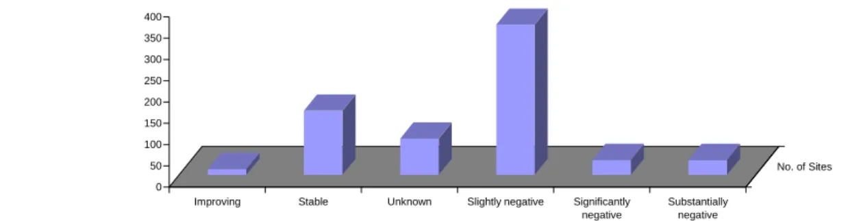
At the individual Site level Ramsar Convention Contracting Parties include general status reports at the time of designation and ideally at six year intervals thereafter. However, there is no measure in place for countries to report objectively changes in actual wetland area or ecological status. Provided that these deficiencies are recognized, Figure 1 based on analysis of data at a Site level within the Ramsar Sites Database shows a trend towards declining ecological health, the majority of Sites (62%) are reported as having negative to very negative changes, while a small minority (2%) record improvements in ecological quality.
Figure 1. Ecological Change status of Ramsar sites within the EEA member countries (source: Ramsar Sites Database, September 2004. vertical axis: numbers of Ramsar sites)
0 50 100 150 200 250 300 350 400
Improving Stable Unknown Slightly negative Significantly negative
Substantially negative
No. of Sites
To overcome the difficulty that much of this data reflects the status of wetlands several years in the past, Wetlands International also relies on additional contextual information. For example, the Pan European Review of Wetland Inventory Information (Nivet, C. and S. Frazier, 2002, 2004), concluded that only 16 countries have adequate national wetland inventory information available. These are the Scandinavian countries (Denmark, Finland, Norway and Sweden), Baltic States (Estonia and Lithuania), Western European countries (Belgium, France, Greece, Spain, Switzerland and the United Kingdom) and Central European countries (Bulgaria, Czech Republic, Slovakia and Slovenia). The report on wetland loss by Jones, T.A. and Hughes, J.M.R. (1993), sets a baseline for loss estimates; some updated loss estimates are available for selected European countries in Nivet and Frazier (2002, 2004). Overall for EEA countries a further 10-15% loss in area may have occurred since 1993 (Wetlands International estimate partly based on National Reports to the Ramsar Convention 1999 and 2002).
Wetlands International, cooperating with the Ramsar Bureau (which conducted a MedWet-based survey), conducted in 2004 a questionnaire-based survey (including 21 drivers) of all National Administrative Authorities and other respondents within the EEA area. Of the 31 EEA-related countries, 18 responded at national or at least at sub-national level. The 13 non-responding countries represent 40% by area of the total Ramsar sites within the EEA countries region. In general, the present ecological status reported is good/declining, however, the significant exceptions are for Greece (inland), Iceland, Italy (Tuscany) and Romania (Danube Delta) where good and improving health is noted, while in Bulgaria wetland status is poor and declining. The net change in health reported since 1993 (or 1991 for MedWet area questionnaires) is good/no change, with the significant exceptions being Bulgaria, Cyprus, France (inland: Languedoc Roussillon), Portugal, and Turkey reporting change as poor/declining. The biodiversity status of wetlands was mostly reported to be the same as the ecological health, although according to case studies cited by the country authorities within their responses, there are specific concerns about many IUCN red listed species and Birds Directive Annex 1 species, due to continuing development pressures.
State and trends for selected waterbird species: For 12 waterbird species representing dependence upon various wetland habitats, data in aggregated form taken from Wetlands International’s International Waterbird Census (mean of combined population levels) is presented in Figure 2 below, for the years 1989 to 2002 and within the EU 25 countries. The trend data is presented for all IWC Sites within an 8km radius of Ramsar sites, and for IWC Sites outside this distance. The population trend is overall stable and also similar for waterbirds inside or outside Ramsar sites, but with some indication that populations are more stable within the neighbourhood of Ramsar sites Figure 2. Population trend for 12 waterbird species. (source: IWC and Ramsar sites database, October 2004)
0.5 0.6 0.7 0.8 0.9 1 1.1 1.2 1.3 1.4 1.5 198 9
1990199 1
199 2
199 3
1994199 5
1996199 7
1998199 9
2000200 1 200 2 R e la ti v e po pul a ti o n s iz e Non-Ramsar Ramsar
Conclusion: Since about 1993, the most significant changes in drivers or pressures related to Ramsar sites as reported by national or local focal points are:
• Increased implementation of conservation management measures
• Increasing Local Community awareness (related to the wetland)
• Increased effect of cultural values and traditions
• Stable or decreasing agricultural intensity
• Increasing agricultural run-off of fertiliser/nutrients
• Tourism, reported as significantly positive or negative
• Urban development
• Alien invasive species
Annex 1
Objectives of the Ramsar site information and database technical support
contract 2003-2005
OBJECTIVE 1: TO MAINTAIN THE RAMSAR SITE INFORMATION AND DATABASE AND SEEK TO IMPROVE THE QUALITY OF DATA HELD
Action 1.1 Create, maintain, and update (as and when new information is provided), hard copy files and the entering of computerised information on each Ramsar site into the Ramsar Sites Database (and each Contracting Party dataset), including, where necessary, image and OCR scans of each RIS.
Action 1.2 Maintain, update and develop the Ramsar Sites Database, ensuring that the database has the most efficient and effective software structure to support the information products and needs described under Objective 2 below.
Action 1.3 Maintain as part of the Ramsar Database, in accordance with Resolution 5.4, information reported by Contracting Parties in fulfilment of Article 3.2. Develop with the Bureau, a simple format for this reporting.
Action 1.4 In consultation with the Ramsar Bureau and the Convention’s Scientific and Technical Review Panel (STRP), and other experts as appropriate, develop structured classification systems for threats and land use information categories (see also Action 2.4), and possibly others, as needed, and as agreed by the Ramsar Bureau.
Action 1.5 Provide the Ramsar Bureau’s Policy and Technical Group with regular (six
monthly) reports indicating site information gaps, sub-standard or non-conforming site descriptions and maps, and, if requested, assist the Ramsar Bureau with
addressing these gaps and limitations in the dataset.
Action 1.6 In consultation with the Ramsar Bureau, assist those Contracting Parties where particular constraints may exist, to compile or improve Ramsar Information Sheets or maps.
Action 1.7 Assist the Ramsar Bureau to obtain electronic mapping and GIS information for Ramsar sites, where it exists, and reference this in the Ramsar Sites Database (see Action 2.2) to support the information products outlined in Objective 2 below.
Action 1.8 Scan all Ramsar Information Sheets (1,100) and then process scans and previously filed electronic versions through Optical Character Recognition (OCR), and link Adobe PDF scans to the Ramsar Sites Database, for use on the Internet
presentation
Action 2.1 Information Requests
Respond to information requests from the Ramsar Bureau, Ramsar Contracting Parties, International Organization Partners, the Center for International Earth Science Information Network (CIESIN), secretariats of other conventions, and other third parties, and maintain a log of such information requests.
Provide a summary report to the Ramsar Bureau and CIESIN* every 6 months of the number
and nature of information requests. (*During the course of the contract, the Ramsar Secretariat
has deleted this requirement with respect to CIESIN.)
In the event of receipt of a request involving a major cost or input of unanticipated work (e.g. a complicated analysis, or a major photocopying request), Wetlands International will seek the Ramsar Bureau’s advice on how to proceed.
Action 2.2 Internet presentation
In consultation with the Ramsar Bureau (Deputy Secretary General and Communications Officer), maintain and further develop Wetlands International’s website presentation of the Ramsar Sites Database and Directory, including the web-enabled Ramsar Sites Database for Bureau and public access. The Internet presentation includes “Graphical Profiles” to enhance awareness and promote interest in the Ramsar List of Wetlands of International Importance. The Profiles will include the standard core set of analyses and displays outlined below.
Additional Profiles may be developed in consultation with the Ramsar Bureau. The presentation will be updated at least every three months to maintain its currency.
Core elements of the Graphical Profile:
• Maps of the world and each region, showing the current distribution of the Contracting Parties and Ramsar sites;
• A map of each Contracting Party, showing the distribution of its Ramsar sites;
• A map of each Ramsar site where digital image versions of the Ramsar site have been provided;
• Pie diagrams showing the distribution of Contracting Parties and Ramsar sites (number and area) per Ramsar region;
• Other thematic maps (e.g. displaying the distribution of “under-represented” wetland types in Ramsar sites – see Actions 3.1 and 3.2 below).
Action 2.3 Ramsar site accounts
One to two-page texts describing each Ramsar site have been compiled (in word-processed files) as part of the Ramsar Sites Database. These have formed the basis of the series A Directory of Wetlands of International Importance.
Action 2.4 Support for the maintenance of the ‘Ramsar Wetland Data Gateway’
Wetlands International and the Center for International Earth Science Information Network (CIESIN), will jointly maintain the “Ramsar Wetland Data Gateway”, for the Ramsar
Convention.
Wetlands International will, at least on a three monthly basis, make available copies of the Ramsar Database in an export format suitable for CIESIN’s use and will also provide on demand full details of the Database structure to enable CIESIN to import the data into their own database structure.
(NOTE: This Action has since been discontinued on advice from the Ramsar Secretariat)
Action 2.5 Prepare a publication with accompanying CD to present the 8th edition of the
Ramsar Sites Directory to COP9
Beginning at Ramsar COP7 (San Jose, 1999), the Directory was distributed only in CD ROM format, and this was repeated for COP8 (Valencia, 2002).
For Ramsar COP9, an updated user-friendly CD ROM will be produced which will feature all Ramsar sites where information has been provided by 1st January 2005. Additionally, an
accompanying booklet (assuming additional funds can be secured) will be produced in English, Spanish and French to act as a guide to the Ramsar Database and the Sites Directory.
OBJECTIVE 3: TO PROVIDE ADVICE FOR IMPLEMENTATION OF THE
STRATEGIC FRAMEWORK FOR THE FUTURE DEVELOPMENT OF THE LIST OF WETLANDS OF INTERNATIONAL
IMPORTANCE
Within the mandate of Ramsar COP Resolutions VII.11 and VIII.38, Wetlands International currentlyprovides benchmark data for the Convention to assist Contracting Parties with the application of Ramsar’s 20,000 and 1% waterbird Criteria (Criteria 5 & 6) for Ramsar site designations. Wetlands International will now move progressively to develop similar benchmark data to guide the application of the other criteria.
In addition, in applying the Strategic Framework and guidelines for the future development of the List of Wetlands of International Importance, Wetlands International is asked to research an integrated approach to designation, which considers biogeography, applies suitable benchmark data, and considers national, regional and global targets for overcoming under-representation.
It is acknowledged that Actions 3.2, 3.3 and 3.4 below are not fully funded at present. Wetlands International will as a priority undertake Action 3.1 and from this recommend priorities for attention with respect to these Actions, including their full cost implications. If it is possible within the existing resources, one example within each category considered under Actions 3.2 (represented/rare types), 3.3 (endangered species/threatened communities etc) and 3.4
(migratory species) will be used as a ‘test’ case to establish the best approaches to be taken and as demonstration illustrations that can be shown to potential funding bodies. The additional
Action 3.1 Following the identification of gaps and identification of priority sites for
designation, Wetlands International will establish and agree with the Ramsar Bureau a procedure and costings for such gap and priority site analyses, and the
identification of relevant information sources which may include inter alia global distribution of wetland types, national wetland inventories, and inventories and directories of important wetlands.
Action 3.2 Further to Action 3.1, Wetlands International will work toward the development of benchmark data to guide the application of Criterion 1 dealing with representative and rare wetland types.
As part of its regular suite of analyses, Wetlands International will review, and keep under review, the status of these broad wetland types within the global Ramsar site listings to identify gaps, and will prepare expert reports (as requested by the Bureau) for each meeting of the STRP, Standing Committee and Ramsar COP9. Contingent upon the acquisition of additional funding, Wetlands International will seek to identify priority sites for designation in order to fill these gaps and achieve the vision, the short and the long-term targets for The List.
Action 3.3 Further to Action 3.1, Wetlands International and the Ramsar Bureau will collaborate with IUCN’s Species Survival Commission and other International Organization Partners to develop benchmark data to guide the application of the Ramsar site designation Criteria (2, 3, 4, 7 & 8) relating to vulnerable and endangered species and threatened ecological communities. Similar reporting to Standing
Committee, STRP and COP9 is expected.
Action 3.4 Further to Action 3.1, and pursuant to the draft Joint Work Plan between the Ramsar Convention and the Convention on Migratory Species, Wetlands
International will review and keep under review the status of Ramsar site listings for migratory species and identify key site networks for these species (in the first
Annex 2. Ramsar Convention meta-database called for by Resolution VII.6
The structure shown here has been implemented as the basis of the meta-database “GlobWetland Information Service”, which is the prototype of the future Ramsar Sites Information Service, and fully satisfies the requirements called for in Resolution VIII.6, A Ramsar Framework for Wetland Inventory. This meta-database is the same as the “GlobWetland database” shown in the diagram within Annex 3.
Custodian Author Title Unique identifier Dataset Related datasets/ projects Scale of inventory
Total area of inventory Ramsar sites Location description
Area of interest coordinates Sub-country (intra-national) Country Ramsar region Wetland type Catalog reference Key word Abstract Description End date Start date Data currency Maintenance frequency Data status /
progress Data status Direct access location Browse image location Access instructions File system location Use constraints Access constraints Stored formats Available format Language of resource Access Completeness Logical consistency Attribute accuracy Positional accuracy Data quality Country State / Province
Email address Facsimile Phone contact Postcode Mail address Contact position Contact organisation Contact information
Date last modified Date of creation
Annex 3. Data model for the relationship between the GlobWetland Database, the Ramsar Sites Database and the Web Mapper
Ramsar sites Data Base on Webserver
Web mapper with remote sensed imagery and maps
Select GW Site records by query
Select GW Site records by Site
Select GW Site records by Country
All or single Site Reports
Export data, incl. map files for Sites selected
Select Map by Country
Select Map by polygon
Sites, Maps & layers selected GlobWetland
Database
Report User Interface to select display, report and download options for GlobWetland Products, Help files and Training materials
GlobWetland Sites and data selected
Primary search and select functions
Secondary Report select functions
GlobWetland Products generated by WetNet and loaded into GlobWetland IS
www.globwetland.org & www.wetlands.org
webservers
Web Mapper Map and layer display control Help files
Training materials
GlobWetland Products