1
DESIGN OF ACTION PLANS AGAINST NOISE IN NAVARRE, SPAIN
PACS: 43.50.Sr
Arana, M.; San Martín, R.; Nagore, I.; Perez, D.
Universidad Pública de Navarra. Departamento de Física. Campus de Arrosadia
31006 Pamplona. Spain Tel:+34 948 169 568 Fax:+34 948 169 565
E-Mail: marana@unavarra.es
ABSTRACT
Strategic noise maps bring us information on noise pollution in our towns. Acoustic zonification defines types of acoustic areas in which the territory is divided according to the corresponding objectives of acoustic quality. By crossing both shapes acoustic-conflict areas can be pointed out. These areas are known as Areas with Special Acoustic Protection. In most towns or agglomerations, the number of such areas is very high or, alternatively, they cover large areas. Given that financial resources to eliminate conflict areas are limited, it is necessary to give priority to the adoption of measures to reduce acoustic pollution. Besides the basic criterion of maximize number of people benefited by measures to implement, feasibility and effectiveness criteria should be taken into account. Therefore, some methodology to give priority to possible action plans is required. In the present paper the process carried out in the case of the actions plans against noise designed in the Autonomous Community of Navarre will be presented.
RESUMEN
2
1. INTRODUCTION
According to Directive 2002/49/EC [1], Member States had to develop action plans to manage ( within their territories) noise impacts and their effects, including noise reduction, if necessary, with respect to: a) areas near major roads which have more than six million vehicles a year, major railways which have more than 60 000 train passages per year and major airports, and b) agglomerations with more than 250 000 inhabitants. Such plans shall also aim to protect quiet areas against any increase of noise. The specific steps of action plans shall be at the discretion of the responsible authorities, but will face in particular the priorities that can be determined as a result of exceeding certain threshold values or by other criteria chosen by the Member States and should be applied in particular to the most impacted areas established in accordance with the corresponding strategic noise maps.
The Law 37/2003 [2] transposed the European Directive into Spanish law, in order to preventing, monitoring and reducing noise pollution. In its article 7 delegates to the Autonomous Communities the classification of acoustic areas, although they have to plan at least the followings: a) Residential areas, b) Industrial areas, c) Recreational and entertainment areas, d) Tertiary areas, e) Health, educational and cultural areas requiring special protection against noise, f) Sectors of the territory concerned to general systems of transport infrastructures, and g) Natural areas requiring special protection against noise pollution. Subsequently, the RD 1367/2007 [3] developed the Law 37/2003. In this Royal Decree criteria are adopted for the delimitation of the different types of acoustic areas. However, the most important aspects of RD 1367/2007 are those relating to the determination of the acoustic quality objectives applicable to acoustic areas (both for outdoor and indoor places) as well as the methods and processes for the evaluation of acoustic indices.
2. STRATEGIC NOISE MAPS OF NAVARRE, SPAIN
[image:2.595.85.475.516.722.2]Six strategic noise maps were conducted for major roads, with a total of-approximately, 120 km and a strategic noise map for the Agglomeration of Pamplona, with an area of 127.41 km2 and a population of 280,199 inhabitants [4]. Figure 1 shows the location of the strategic noise maps carried out.
3
With respect to the affected population, the results showed that seven hundreds of people are exposed to levels above 65 dBA for the index Ld and 31 hundreds of people are exposed to levels above 55 dBA for the index Ln, with respect to the six strategic noise maps of major roads. In the Agglomeration of Pamplona, such values are, respectively, 259 and 364, also in hundreds. The cause of such levels is due (in a percentage above 99%) to road traffic.
3. ACOUSTIC CLASSIFICATION AND INCOMPATIBILITY AREAS
By working together with each and every one of the local governments, the acoustic classification of the territory was carried out. In addition to the minimum acoustic classification prescribed by the Law 37/2003, rustic areas were added. Acoustics zonification was carried out in the area bounded by the acoustical servitude zones of the major roads as well as the agglomeration of Pamplona. For all Navarre next areas were classified (Table 1):
Table 1. Classified areas by uses
Acoustic class Classified area (has.)
Healthy-Educational-Cultural (SDC) 524
Residential (RES) 3.176
Recreational and entertainment (REC) 348
Tertiary(TER) 742
Industrial (IND) 1.929
Infrastructures (INF) 1.027
TOTAL 7.746
4
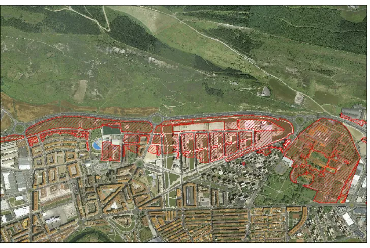
Fig. 2. Example of conflict areas (major roads)
As final result of the crossing of shapes, a total of 1,532 incompatibility areas were found, distributed as it is shown in Table 2.
Table 2. Conflict areas in the strategic noise maps of Navarre, Spain
Acoustic class Number Area (m2)
Healthy-Educational-Cultural (SDC) 222 1,876,951 Residential (RES) 1,163 3,794,215 Recreational and entertainment (REC) 8 48,501
Tertiary(TER) 46 159,018
Industrial (IND) 93 357,772
TOTAL 1,532 6,236,457
To summarize (and based on Ln index) the study highlighted that the total area affected by incompatibilities in the full scope of strategic noise maps in Navarre is 624 has, i.e., an 8% of the total classified area. Also, in the Agglomeration of Pamplona, the number of people living in conflict areas is 36,384, which represents a 13% of the population included in the urban agglomeration.
4. PRIORITIZATION CRITERIA FOR THE DESIGN OF ACTION PLANS
[image:4.595.86.478.450.557.2]5
4.1 Major roads
In order to prioritize incompatibility areas three parameters were introduced:
.- Incidence. That is a function of both the number of people affected and the amount of the exceeded level.
.- Feasibility/effectiveness. Depending both on the complexity of the performance and on the reduction produced by the mitigation action.
- Priority. Based on the above two parameters is assessed as “high”, “medium” or “low” and will serve as final indicator of the classification.
In the case of acoustic areas classified as RES, the value assigned to the parameter incidence was evaluated by calculating the product of the number of people affected by the amount of exceeded level with regard to the quality objective. Depending on the value of this parameter incidences were classified as "low" (value of the parameter between 0 and 25), "medium" (value of the parameter between 25 and 100) and "high" (value of the parameter greater than 100). Furthermore, incidence was classified as "high" for all the acoustic areas classified as SDC where the quality objective was exceeded. The remaining acoustic areas (RET, REC and IND) were considered with affection "low".
With regard to the parameter feasibility/effectiveness, were classified as "high" those situations where it is easy to place a barrier and the result is highly effective. Those where there are elements that complicate the placement of a barrier or topographic configuration reduces the effectiveness of it, were rated as "average". Finally, were classified as "low" those situations where either it is very difficult to place a barrier or its implementation would be very inefficient. The final criterion adopted to assess the priority of the conflict areas was as follows: only those areas with incidence "high" and feasibility/effectiveness “high" were classified as "high" priority for action plans. The remainders-according to the two criteria discussed above, were classified as "medium" or "low" priority. As final result seven areas of incompatibility with "high" priority were found, being four of them of SDC class and three of RES class, affecting-in the last case, to a total of 1,013 people. For all of them, specific action plans were designed, consisting in installation of sound barriers eliminating the incompatibility.
4.2 ACP
6
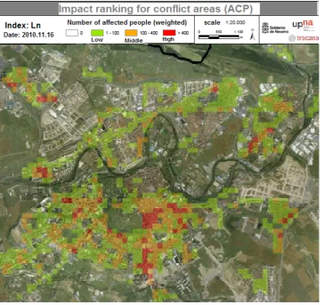
Fig.3 Grid of impact ranking (ACP)
Areas with the highest percentage of affected population (red and orange in figure 3) are located along roads with heavy traffic and reverberant urban configuration, with buildings on both sides of the road. These areas have to be of high priority for the development of action plans, although they are main and essential roads (at now) for mobility.
The action plans developed for conflict areas within agglomerations present much more difficulties than those required for major roads. Usually, they are consolidated urban frame, with high population density and several roads/streets with high traffic density. The two main tools in these cases for reducing the noise are a) to pedestrianize and b) To state "Area 30", giving priority to public transport (electric or hybrid if possible) in front of private transport. Both involve to present alternatives for the existing mobility, issues hard to reconcile. The action plans designed for the ACP were based in such aspects.
7
by comparing the results of acoustic maps carried out in Pamplona in 1989 and 2009 [7]. In contrast, the acoustic pollution in the surrounding areas-where bypasses run, had a noticeable increase.
CONCLUSIONS
Action plans are important tools to reduce noise in our agglomerations. By crossing the land acoustic classification with the noise maps, incompatibility areas are detected. Given the large number of incompatibilities as well as the limited financial resources, some criteria to prioritize conflict areas are needed. The criteria used in the design of action plans against noise in Navarre have been shown in this study. They have been based in the prioritization of the most sensitive areas (S/D/C) and the parameter obtained by multiplying the number of people affected by the amount of the increase of the acoustic quality objective, in the case of residential (RES) areas.
REFERENCES
[1] Directive 2002/49/EC of the European Parliament and of the Council of 25 June 2002 relating to the assessment and management of environmental noise. (2002).
[2] Ley 37/2003, BOE n. 276, pp: 40494-40505 (in Spanish). (2003) [3] RD 1367/2007, BOE n. 254, pp: 42952-73 (in Spanish). (2007) [4] http://idena.navarra.es/busquedas/catalog/search/search.page
[5] S. Luzzi; R. Bellomini; F. Borchi, Harmonization of action plans and noise reduction plans: the HUSH project, InterNoise 2010, Lisbon, Protugal. (2010)
[6] M. Arana and A. Garcia, A social survey on the effects of environmental noise on the residents of Pamplona, Spain, Appl. Acoust. 53, 245–253, (1998).