Wetland inventory
Handbooks
4
thedition
The Convention on Wetlands (Ramsar, Iran, 1971) is an
intergovernmental treaty whose mission is “the conservation and wise use of all wetlands through local, regional and national actions and international cooperation, as a contribution towards achieving sustainable development throughout the world”. As of October 2010, 160 nations have joined the Convention as Contracting Parties, and more than 1900 wetlands around the world, covering over 186 million hectares, have been designated for inclusion in the Ramsar List of Wetlands of International Importance.
What are wetlands?
As defined by the Convention, wetlands include a wide variety of habitats such as marshes, peatlands, floodplains, rivers and lakes, and coastal areas such as saltmarshes, mangroves, and seagrass beds, but also coral reefs and other marine areas no deeper than six metres at low tide, as well as human-made wetlands such as waste-water treatment ponds and reservoirs.
About this series of handbooks
This series has been prepared by the Secretariat of the Convention following the 7th, 8th 9th, and 10th meetings of the Conference of
the Contracting Parties (COP7, COP8, COP9 and COP10) held, respectively, in San José, Costa Rica, in May 1999, Valencia, Spain, in November 2002, Kampala, Uganda, in November 2005, and Changwon, Republic of Korea, October-November 2008. The guidelines on various matters adopted by the Parties at those and earlier COPs have been prepared as a series of handbooks to assist those with an interest in, or directly involved with, implementation of the Convention at the international, regional, national, subnational or local levels. Each handbook brings together, subject by subject, the various relevant guidances adopted by Parties, supplemented by additional material from COP information papers, case studies and other relevant publications so as to illustrate key aspects of the guidelines. The handbooks are available in the three working languages of the Convention (English, French, and Spanish). The table on the inside back cover lists the full scope of the subjects covered by this handbook series at present. Additional handbooks will be prepared to include any further guidance adopted by future meetings of the Conference of the Contracting Parties. The Ramsar Convention promotes an integrated package of actions to ensure the conservation and wise use of wetlands. In recognition of these integrated approaches, the reader will find that within each handbook there are numerous cross-references to others in the series.
Copyright © 2010, Ramsar Convention Secretariat Citation: Ramsar Convention Secretariat, 2010. Wetland inventory: A Ramsar framework for wetland inventory and ecological character
description. Ramsar handbooks
for the wise use of wetlands, 4th edition, vol. 15. Ramsar
Convention Secretariat, Gland, Switzerland.
Reproduction of material from this publication for educational and other non-commercial purposes is authorized without prior permission from the Ramsar Secretariat, providing full acknowledgement is given. Series Editor: Dave Pritchard Series Supervisor: Nick Davidson Design and layout: Dwight Peck
Handbook 15
4
edition, 2010
Wetland inventory
A Ramsar
framework for
wetland inventory
and ecological
character description
This 4th edition of the Ramsar Handbooks replaces the series published in 2007. It includes
relevant guidance adopted by several meetings of the Conference of the Parties, in particular COP7 (1999), COP8 (2002), COP9 (2005), and COP10 (2008), as well as selected background
Acknowledgements
The Framework for Wetland Inventory which forms the basis for this Handbook was prepared by the Scientific and Technical Review Panel’s Expert Working Group on Wetland Inventory, led by Max Finlayson (Australia). The “Recommended standard metadata record for the documentation of wetland inventories” provided in Appendix V of the Framework was developed for the Ramsar Convention by John Lowry and Max Finlayson, then of the Environmental Research Institute of the Supervising Scientist (eriss), Australia, with the financial support of the government of the
United Kingdom, as support for the development of a second phase of the Global Review of Wetland
Resources and Priorities for Wetland Inventory (GRoWI 2).
The framework and guidance on harmonized data and information for core inventory, wetland ecological character description, Ramsar Site designation, and Article 3.2 reporting was developed by Dave Pritchard, then of BirdLife International, during a period of secondment to the Ramsar Secretariat.
All Resolutions of the Ramsar COPs are available from the Convention’s Web site at www. ramsar.org/resolutions. Background documents referred to in these handbooks are available at www.ramsar.org/cop7-docs, www.ramsar.org/cop8-docs, www.ramsar.org/cop9-docs, and
Table of Contents
AcknowledgementsGetting the most out of this Handbook Foreword
A Framework for wetland inventory and ecological character description
Background and context
A Framework for wetland inventory 1. State the purpose and objective
2. Review existing knowledge and information 3. Review existing inventory methods
4. Determine the scale and resolution 5. Establish a core or minimum data set 6. Establish a habitat classification 7. Choose an appropriate method 8. Establish a data management system
9. Establish a time schedule and the level of resources that are required 10. Assess the feasibility & cost effectiveness
11. Establish a reporting procedure 12. Review and evaluate the inventory 13. Plan a pilot study
Implementation of the inventory
Describing the ecological character of individual wetlands Appendix I: Inventory methods
Appendix II: Determining the most appropriate remotely sensed data for a wetland inventory
Appendix III: Summary of remotely sensed data sets applicable to wetland inventory Appendix IV: Wetland classifications
Appendix V: Recommended standard metadata record for the documentation of wetland inventories
Appendix VI: Reading list
Additional Appendix
Ramsar COP7 DOC. 19.3: Global Review of Wetland Resources and Priorities for Wetland
Inventory - Summary Report
Relevant Resolutions
Resolution VIII.6: A Ramsar Framework for Wetland Inventory
Resolution VI.12: National Wetland Inventories and candidate sites for listing
Resolution VII.20: Priorities for wetland inventory
Resolution X.15: Describing the ecological character of wetlands, and data needs and formats for
core inventory: harmonized scientific and technical guidance
Getting the most out of this Handbook
The Handbooks in general
The purpose of the Ramsar Handbooks is to organize guidance material from relevant decisions adopted by the Contracting Parties over the years, according to subject themes. This helps practitioners to implement the internationally-agreed best practice in a way that is convenient to handle and more naturally matches their own everyday working environment.
The intended readership includes national and local staff of the government departments, ministries and agencies that act as Administrative Authorities for the Ramsar Convention in each country. Equally important users in many cases are managers of individual wetland areas, as some aspects of the guidance relate specifically to site management.
The Ramsar guidance has been adopted by member governments as a whole, and increasingly it addresses itself to the crucial roles of other sectors beyond the “environment” or “water” sectors. It
is thus very important that these Handbooks should be used by all whose actions may benefit from
or impact upon the wise use of wetlands.
A vital first step in each country therefore is to ensure adequate dissemination of these Handbooks
to all who need or can benefit from them. Copies are freely available in PDF format from the Ramsar Secretariat in three languages on CD-ROM or by download from the Convention website (www.ramsar.org).
Other early steps would be, in each particular context, to clarify lines of responsibility and actively
check how to align the terms used and approaches described with the reader’s own jurisdiction, operating circumstances, and organizational structures.
Much of the text can be used in a proactive sense, as a basis for framing policies, plans and
activities, sometimes by simply importing relevant sections into national and local materials. It
can also be used in a reactive sense as a source of help and ideas for responding to problems and
opportunities, navigating subjects by the need of the user.
Cross-references, original sources, and further reading are liberally cited: the Handbooks will often not be the “last word”, but they provide a helpful “route-map” to further sources of information and support.
Strategic direction in the Ramsar Convention is provided by the Strategic Plan, the latest version of which was adopted by COP10 in 2008 for the period 2009-2015. All thematic implementation frameworks, including the Handbooks, sit within the context of the goals and strategies of this Plan and the priorities it highlights for the period covered.
This Handbook (Wetland inventory)
Strategy 1.1 of the Strategic Plan on “Wetland inventory and assessment” includes Key Result Area 1.1.i (to be achieved by 2015) as follows: “All Parties to have completed national wetland inventories in line with the Ramsar Framework for Wetland Inventory and as far as possible to have disseminated comprehensive national wetland inventories, including information on wetland importance, potential Ramsar Sites, wetlands for restoration, location of under-represented
wetland types, and the ecosystem services provided by wetlands”.
Concerning description of ecological character, Strategy 2.4 on Ramsar Site ecological character includes Key Result Area 2.4.v (to be achieved by 2015): “Statements of ecological character finalized for all Ramsar Sites and used as a basis for implementing Article 3.2 of the Convention”. The text in this Handbook is based on Resolutions VIII.6 and X.15 and their Annexes. The
substance of it thus reflects formal decisions adopted by the Conference of Contracting Parties. The Handbook also brings together additional information relevant to this issue. The views expressed in this additional information do not necessarily reflect the views of the Ramsar Secretariat or the Contracting Parties, and such materials have not been endorsed by the Conference of the Contracting Parties.
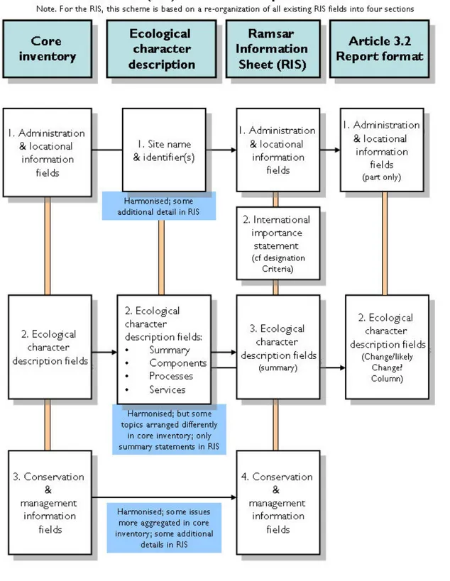
Foreword
The Ramsar Convention on Wetlands has always recognized the importance of national wetland inventories as a key tool for informing policies and other actions to achieve the conservation and wise use of wetlands. As early as the 1st meeting of the Conference of the Contracting Parties (COP1, Cagliari, 1980), Parties were convinced that national wetland policies should be based on a nationwide inventory of wetlands and of their resources (Recommendation 1.5). This recognition of the value of national wetland inventories has been regularly reiterated by subsequent COPs, including in the Annex to Recommendation 2.3 (COP2, Groningen, 1984), Recommendation 4.6 (COP4, Montreux, 1990), Resolution 5.3 (COP5, Kushiro, 1993), and Resolution VI.12 (COP6, Brisbane, 1996).
The Convention has also recognized that national wetland inventories, as well as being an essential
basis for the formulation of national wetland policy, are equally important for inter alia identifying
sites suitable for inclusion in the List of Wetlands of International Importance (the Ramsar List), for quantifying the global wetland resource as the basis for assessment of its status and trends, for identifying wetlands suitable for restoration, and for risk and vulnerability assessments.
In 1998, in response to Action 6.1.3 of the Convention’s Strategic Plan 1997-2002, Wetlands International and the Environmental Research Institute of the Supervising Scientist, Australia,
undertook for the Ramsar Convention a Global Review of Wetland Resources and Priorities for Wetland
Inventory (GRoWI) project. This reviewed the extent and status of national wetland inventories. The findings of this analysis were presented to a Technical Session of COP7 in San José in 1999 and are summarised in a COP7 Background Paper (Ramsar COP7 DOC. 19.3) available at www.ramsar.org/cda/en/ramsar-documents-cops-cop7-ramsar-cop7-doc-19-3/main/ramsar/1-31-58-83%5E18751_4000_0__ and as an Additional Appendix to this Handbook. The project’s recommendations were incorporated in Resolution VII.20 on Priorities for wetland inventory, and the full set of global and regional GRoWI reports are available for download in Word format from http://www.wetlands.org/RSIS/WKBASE/GRoWI/welcome.html.
To provide the further guidance to Contracting Parties on inventory methodologies called for
in Resolution VII.20, the Convention’s Scientific and Technical Review Panel (STRP) prepared A
and forms the main part of this Handbook. The framework provides guidance for planning and designing an appropriate wetland inventory, recognizing that the actual inventory approach adopted will depend on its purpose and objectives, as well as the capacity and resourcing for undertaking the inventory. Appendices to the Framework provide further information on a number of standardised inventory methods which have been successfully applied in different parts of the world, additional guidance on determining appropriate use of remotely sensed data in inventory, information on a range of different wetland classifications which have been applied to wetland inventory, and a summary of a recommended standard metadata record for documenting wetland inventories.
Contracting Parties at COP8 requested the STRP, through Resolution VIII.6, to undertake further work in preparing guidance on certain aspects of wetland inventory, including on remote sensing data, low-cost geographical information systems, and classification systems in wetland inventory, and, through Resolution VIII.7, to undertake further work to address recognized gaps and disharmonies in guidance on ecological character, inventory, assessment, monitoring and management of Ramsar Sites and other wetlands. This latter Resolution also requested the STRP to consider consolidation of the Framework for Wetland Inventory into an Integrated Framework for Wetland Inventory, Assessment and Monitoring (IF-WIAM), which was duly approved by COP9 in 2005 (Resolution IX.1 Annex E) and is now available as Handbook 13 in this fourth edition of the Handbook series.
A Framework for wetland inventory and ecological character
description
(based on the Annexes to Resolutions VIII.6 and X.15 of the 8th and 10th meetings of the Conference of the Contracting Parties, Spain, 2002 and Republic of Korea, 2008)
Relevant implementation commitments made by Contracting Parties in COP Resolutions
Resolution VI.12: National Wetland Inventories and candidate sites for listing
THE CONFERENCE OF THE CONTRACTING PARTIES
4. ENCOURAGES Contracting Parties, in establishing and maintaining national scientific inventories of wetlands, to include all wetlands; and
5. URGES each Contracting Party to recognize officially its identified sites meeting the criteria approved by the Conference of the Contracting Parties.
Resolution VII.20: Priorities for wetland inventory
THE CONFERENCE OF THE CONTRACTING PARTIES
11. URGES all Contracting Parties yet to complete comprehensive national inventories of their wetland resources, including, where possible, wetland losses and wetlands with potential for restoration (Resolution VII.17), to give highest priority in the next triennium to the compilation of comprehensive national inventories, in order for related actions such as policy development and Ramsar Site designations to be carried out with the best information possible;
12. FURTHER URGES that in undertaking inventory activities Contracting Parties give consideration to affording highest priority to those wetland types identified as at greatest risk or with poorest information in the Global review of wetland resources and priorities for wetland inventory report;
Resolution VIII.6: A Ramsar framework for wetland inventory
THE CONFERENCE OF THE CONTRACTING PARTIES
15. RECOGNIZES that it is appropriate to apply different wetland inventory approaches, methods and wetland classifications for different purposes and objectives, but that common standards can be achieved by ensuring consistency in the collection of a core (minimum) dataset, as provided in the Framework;
16. URGES all Contracting Parties that have yet to complete comprehensive national wetland inventories to continue to give a high priority in the next triennium to the compilation of such inventories, utilizing the Framework for Wetland Inventory to ensure that their inventory design appropriately addresses their purpose and objectives, in order that their activities that require the sound basis of wetland inventory, such as policy development and Ramsar Site designations, can be carried out on the basis of the best possible information;
18. CALLS UPON Contracting Parties that have undertaken wetland inventories to ensure that they have appropriate arrangements in place for housing and maintaining their wetland inventory data, […] and, where appropriate, to make this data and information available […] to all decision-makers, stakeholders, and other interested parties;
Resolution X.15: Describing the ecological character of wetlands, and data needs and formats for core inventory: harmonized scientific and technical guidance
Background and context
1. In Resolution VII.20 (1999) the Contracting Parties recognized the
importance of comprehensive national inventory as the vital basis for many activities necessary for achieving the wise use of wetlands, including policy development, identification and designation of Ramsar Sites, documentation of wetland losses, and identification of wetlands with potential for
restoration (see also Resolutions VII.16 and VIII.17). It also encouraged the collection of information for the management of shared wetlands, including those within river basins and/or coastal zones (see also Resolutions VII.18 and VIII.4) as appropriate. Furthermore, Operational Objective 1 of the Convention’s Strategic Plan 2003-2008 [was] devoted to wetland inventory and assessment, with a series of concrete actions to achieve this Operational Objective.
2. The Global Review of Wetland Resources and Priorities for Wetland Inventory
(GRoWI), prepared in 1999 for the Ramsar Convention by Wetlands International and the Environmental Research Institute of the Supervising Scientist, Australia, indicated that few countries have comprehensive national inventories of their wetland resources, and lack this essential baseline information on their wetlands. In addition, the National Reports submitted to Ramsar COP8 indicated that insufficient progress has been made in wetland inventory.
3. The GRoWI review concluded that a clear identification and statement of purpose and objectives is fundamental to the design and implementation of effective and cost-efficient inventory, but found that the purpose and objectives for many existing inventories were poorly, if at all, stated. 4. In Resolution VII.20 the COP urged Contracting Parties which had yet to
complete national inventories of their wetland resources to give the highest priority to the compilation of comprehensive wetland inventories, and requested the Convention’s Scientific and Technical Review Panel (STRP) to review and further develop existing models for wetland inventory and data management, including the use of remote sensing and low-cost and user-friendly geographic information systems.
4. WELCOMES the guidance on “Describing the ecological character of wetlands, and harmonized data formats for core inventory” provided in the annex to this Resolution, and URGES Contracting Parties to make good use of it as appropriate, adapting it as necessary to suit national conditions and circumstances, within the frameworks of existing regional initiatives and commitments and in the context of sustainable development;
5. This Framework for Wetland Inventory has been developed by the STRP, working with the Ramsar [Secretariat], Wetlands International, the
Environmental Research Institute of the Supervising Scientist (Australia) and others, in response to Resolution VII.20. The Framework provides guidance on a standard approach to designing a wetland inventory program. It includes information on determining appropriate remote sensing techniques to apply, wetland classifications and existing standardised inventory
methods, and recommends standards for core data fields and data and metadata recording.
6. The Framework provides guidance for designing wetland inventory at multiple scales from site-based to provincial, national and regional. The extent of detail that can be compiled in the inventory will generally decrease as the geographical area of coverage increases, unless large resources can be allocated for the program.
7. The data fields included in any particular inventory will be based on the specific purpose and scale of the inventory. A core data set is recommended as a minimum, but with the option of adding further data fields as required. 8. The Framework uses the definition of “inventory” agreed in Workshop 4
on Wetland Inventory, Assessment and Monitoring – Practical Techniques and Identification of Major Issues held during the 2nd International Conference on Wetlands and Development, Dakar, Senegal, 8-14 November 1998 (Finlayson et al. 2001). The definition is provided below along with those for the inter-connected concepts of assessment and monitoring:
Wetland inventory: The collection and/or collation of core information for wetland management, including the provision of an information base for specific assessment and monitoring activities.
Wetland assessment: The identification of the status of, and threats to, wetlands as a basis for the collection of more specific information through monitoring activities.
Wetland monitoring: Collection of specific information for management purposes in response to hypotheses derived from assessment activities, and the use of these monitoring results for implementing management. (Note that the collection of time-series information that is not hypothesis-driven from wetland assessment should be termed surveillance rather than monitoring, as outlined in Resolution VI.1.) 9. It is important to distinguish between inventory, assessment and monitoring
when designing data gathering exercises, as they require different categories of information. Wetland inventory provides the basis for guiding the
development of appropriate assessment and monitoring, but wetland inventories repeated at given time intervals do not constitute ‘monitoring’.
A framework for wetland inventory
10. A structured framework for planning and designing a wetland inventory is summarized in Table 1. The framework comprises 13 steps that provide the basis for making decisions in relation to the purpose (and objectives), and the available resources, for an inventory.
11. All steps in the Framework are applicable to the planning and
implementation of any wetland inventory, and all steps should therefore be followed during the design and planning process. The framework does not provide prescriptive guidance on particular inventory methods; rather it provides guidance to the Contracting Parties and others who are planning to undertake wetland inventory by drawing attention to different methods and wetland classifications already in use and of proven utility under different circumstances.
12. The framework should be used as a basis for making decisions for
undertaking a wetland inventory under the circumstances particular to each inventory program. Guidance on the application of each step is provided.
Table 1. A structured framework for planning a wetland inventory
Step Guidance
1. State the purpose
and objective State the reason(s) for undertaking the inventory and why the information is required, as the basis for choosing a spatial scale and minimum data set.
2. Review existing knowledge and information
Review the published and unpublished literature and determine the extent of knowledge and information available for wetlands in the region being considered.
3. Review existing
inventory methods Review available methods and seek expert technical advice to: a) choose the methods that can supply the required information; and b) ensure that suitable data management processes are established.
4. Determine the
scale and resolution Determine the scale and resolution required to achieve the purpose and objective defined in Step 1.
5. Establish a core or
minimum data set Identify the core, or minimum, data set sufficient to describe the location and size of the wetland(s) and any special features. This can be complemented by additional information on factors affecting the ecological character of the wetland(s) and other management issues, if required.
6. Establish a habitat
classification Choose a habitat classification that suits the purpose of the inventory, since there is no single classification that has been globally accepted.
7. Choose an
8. Establish a data
management system Establish clear protocols for collecting, recording and storing data, including archiving in electronic or hardcopy formats. This should enable future users to determine the source of the data, and its accuracy and reliability.
At this stage it is also necessary to identify suitable data analysis methods. All data analysis should be done by rigorous and tested methods and all information documented. The data management system should support, rather than constrain, the data analysis.
A meta-database should be used to: a) record information about the inventory datasets; and b) outline details of data custodianship and access by other users.
9. Establish a time schedule and the level of resources that are required
Establish a time schedule for: a) planning the inventory; b) collecting, processing and interpreting the data collected; c) reporting the results; and d) regular review of the program.
Establish the extent and reliability of the resources available for the inventory. If necessary make contingency plans to ensure that data is not lost due to insufficiency of resources.
10. Assess the feasibility & cost effectiveness
Assess whether or not the program, including reporting of the results, can be undertaken within under the current institutional, financial and staff situation.
Determine whether the costs of data acquisition and analysis are within budget and that a budget is available for the program to be completed.
11. Establish a
reporting procedure Establish a procedure for interpreting and reporting all results in a timely and cost effective manner. The report should be succinct and concise, indicate whether or not the objective has been achieved, and contain recommendations for management action, including whether further data or information is required.
12. Establish a review and evaluation process
Establish a formal and open review process to ensure the effectiveness of all procedures, including reporting and, when required, supply information to adjust or even terminate the program.
13. Plan a pilot study Test and adjust the method and specialist equipment being used, assess the training needs for staff involved, and confirm the means of collating, collecting, entering, analysing and interpreting the data. In particular, ensure that any remote sensing can be supported by appropriate “ground-truth” survey.
Step 1 State the purpose and objective
13. Wetland inventory has multiple purposes. These include: a) listing particular types, or even all, wetlands in an area;
b) listing wetlands of local, national and/or international importance; c) describing the occurrence and distribution of wetland taxa; d) describing the occurrence of natural resources such as peat, fish or
water;
f) assessing the extent and rate of wetland loss or degradation; g) promoting awareness of the value of wetlands;
h) providing a tool for conservation planning and management; and
i) developing networks of experts and cooperation for wetland
conservation and management.
14. An inventory should contain a clear statement of its purpose and objective. This should identify the habitats that will be considered, the range of information that is required, the time schedule, and who will make use of the information.
15. A clear statement of the purpose(s) will assist in making decisions about the methods and resources needed to undertake the inventory.
Step 2 Review existing knowledge and information
16. Past investigations have resulted in the provision of broad-scale wetland inventory information for many parts of the world. Other, more detailed, but localized inventory may have been undertaken, restricted either
geographically or to particular wetland habitats or ecosystems in the region under consideration.
17. Valuable information may be held in many different formats and/or by many different organizations (e.g., waterbird, fisheries, water quality and agricultural information bases, and local people’s information and knowledge).
18. A comprehensive review of existing data sources may be necessary and its relevance to the proposed inventory work ascertained.
Step 3 Review existing inventory methods
19. A number of established methods for wetland inventory exist. The
characteristics of five examples […] are summarized in Appendix I. Further sources of information are listed in Appendix VI. The techniques and habitat classifications used in these methods have been successfully adapted for use in a number of locations.
20. The review should determine whether or not existing established inventory methods are suitable for the specific purpose and objectives of the inventory being planned.
21. Some inventory methods use a linked hierarchical approach, in which inventory may be designed at different spatial scales for different purposes. 22. Many inventories have been based on ground-survey, often with the support
of aerial photography and topographical maps and, more recently, satellite imagery. The development of Geographic Information Systems (GIS) and the enhanced resolution of satellite imagery have resulted in greater use of spatial data.
23. A procedure for determining which remotely sensed datasets are the most appropriate for particular purposes, including their use in GIS, is given in
Appendix II.A summary of [some] remote sensing data sets that can be
Step 4 Determine the scale and resolution
24. The spatial scale used for wetland inventory is inseparable from its objective and greatly influences the selection of the method to be used.
25. Wetland inventory has been carried out at a number of spatial scales, with specific objectives at each scale. When choosing the scale it is necessary first to determine the objective and then assess how this can be achieved through a chosen scale.
26. Suitable scales for wetland inventory within a hierarchical approach are: a) wetland regions within a continent, with maps at a scale of 1:1,000,000 –
250,000
b) wetland aggregations within each region, with maps at a scale of 1:250,000 – 50,000
c) wetland sites within each aggregation, with maps at a scale of 1:50,000 – 25,000.
27. The choice of scale is also related to the size of the geographic area involved and to the accuracy required and achievable with available resources. 28. Each of the scales needs a minimum mapping unit that reflects the minimum
acceptable accuracy for that scale. This is done by first determining what is the minimum size of feature that can be clearly delineated at that scale, to acceptable standards, and by then determining what measures are required to describe the accuracy/confidence of defining the unit. For example, a land systems map compiled to a scale of 1:250,000 typically involves taking one on-the-ground site observation for every 600 ha surveyed.
Step 5 Establish a core or minimum data set
29. A core or minimum data set sufficient to describe the wetland(s) should be determined. The specific details of this data set are inseparable from the level of complexity and the spatial scale of the inventory.
30. It is recommended that sufficient information (the core, or minimum, data set) should be collected so as to enable the major wetland habitats to be delineated and characterized for at least one point in time.
31. [Analyses undertaken by the Scientific and Technical Review Panel prior to COP10 identified a number of aspects of the core data fields originally described in the Annex to Resolution VIII.6 where harmonization of terminologies and structure and content descriptions of data and information fields could be made, in order to facilitate the sharing of data and information between inventory and ecological character description processes. Accordingly in Resolution X.15 (2008) the Parties agreed a revised set of core fields to replace those in Resolution VIII.6].
of this information does not detract from the primary purpose of obtaining sufficient information to enable the delineation and characterization of the wetland(s).
33. [A summary description and structure of recommended core data fields for wetland inventory, as identified in the Annex to Resolution X.15, is given in Table 2. The relationship of these fields to the description of the ecological character of wetlands is shown in Table 3].
Table 2. Core (minimum) data fields for [wetland inventory] Revised core wetland inventory fields
(Harmonized with Ramsar ecological character description sheet) Site name:
Official name of site and catchment/other identifier(s) (e.g., reference number)
Area, boundary and dimensions:
Site shape (cross-section and plan view), boundaries, area, area of water/wet area (seasonal max/ min where relevant), length, width, depth (seasonal max/min where relevant)
Location:
Projection system, map coordinates, map centroid, elevation
Geomorphic setting:
Setting in the landscape/catchment/river basin - including altitude, upper/lower zone of catchment, distance to coast where relevant, etc.
Biogeographical region: Climate:
Overview of prevailing climate type, zone and major features (precipitation, temperature, wind)
Soil:
Geology, soils and substrates; and soil biology
Water regime:
Water source (surface and groundwater), inflow/outflow, evaporation, flooding frequency, seasonality and duration; magnitude of flow and/or tidal regime, links with groundwater
Water chemistry:
Temperature; turbidity; pH; colour; salinity; dissolved gases; dissolved or suspended nutrients; dissolved organic carbon; conductivity
Biota:
Plant communities, vegetation zones and structure (including comments on particular rarity, etc.);
Animal communities (including comments on particular rarity, etc.);
Main species present (including comments on particular rare/endangered species, etc.); population size and proportion where known, seasonality of occurrence, and approximate position in distribution range (e.g., whether near centre or edge of range)
Land use:
Local, and in the river basin and/or coastal zone
Pressures and trends:
Concerning any of the features listed above, and/or concerning ecosystem integrity
Land tenure and administrative authority:
Conservation and management status of the wetland:
Including legal instruments and social or cultural traditions that influence the management of the wetland; and including protected area categories according to the IUCN system and/or any national system
Ecosystem services:
(for a list of relevant ecosystem services, see the Ramsar ecological character description sheet)
Management plans and monitoring programs:
In place and planned within the wetland and in the river basin and/or coastal zone (see Resolutions 5.7, VI.1, VII.17, and VIII.14)
Step 6 Establish a habitat classification
34. Many national wetland definitions and classifications are in use (Appendix IV). These have been developed in response to different national needs and take into account the main biophysical features (generally vegetation, landform and water regime, sometimes also water chemistry such as salinity) and the variety and size of wetlands in the locality or region being considered.
35. The Ramsar Classification System for Wetland Type (Resolution VI.5) is increasingly being used as a classification basis for national wetland inventories. However, when it was first developed it was not anticipated that the Ramsar classification would be used for this inventory purpose, so its usefulness as a habitat classification for any specific wetland inventory should be carefully assessed. Whilst the Ramsar Classification System has value as a basic habitat description for sites designated for the Ramsar List of Wetlands of International Importance, it does not readily accommodate description of all wetland habitats in the form and level of description that are now commonly included in many wetland inventories.
36. A classification based upon the fundamental features that define a wetland – the landform and water regime – is considered to be superior to those based on other features (Resolution VII.20). The basic landform and water regime categories within such a classification can be complemented with modifiers that describe other features of the wetland, for example, for vegetation, soils, water quality, and size.
37. As it is unlikely that a single classification can be globally acceptable, not least because different classification systems are required by some national legislations, a classification should be chosen that suits the purpose of the inventory. The core biophysical data recommended to be collected in an inventory (Table 2) may be used to derive a classification that suits individual needs.
Step 7 Choose an appropriate method
38. Many inventory methods are available (see Appendices I and IV for
39. To assist in determining which remote sensing data is most useful for a particular inventory, a simple decision-tree is provided in Appendix II. The decision-tree is also presented pictorially and contains six steps to assist in determining which data are most suitable. Importantly, the extent of “ground-truth” survey required to validate the remote sense data should be assessed when considering such techniques.
40. Physico-chemical and biological sampling should be undertaken whenever possible by standard laboratory and field methods that are well documented and readily available in published formats. There is a variety of acceptable methods in use. The bibliographical details of those used should be
recorded and any departures from standard procedures clearly justified and documented.
41. As a general rule, the inventory method chosen should be sufficiently robust to ensure that the required data can be obtained within the constraints imposed by the terrain, resources, and time period available. Where adequate methods do not exist, well-directed research is needed to develop or identify specific techniques.
42. The use of Geographic Information Systems (GIS) for managing spatial data, in particular, is encouraged, noting that low-cost GIS platforms are increasingly available and widely-used.
Step 8 Establish a data management system
43. Increasing use of databases and Geographic Information Systems ensure that a large amount of data can be stored and displayed, but these capabilities will be undermined if the data are not well managed and stored in formats that are readily accessible.
44. Potential data management problems can be overcome by establishing clear protocols for collecting, recording and storing data, including archiving data in electronic and/or hardcopy formats. The protocols should enable future users to determine the source of the data, as well as its accuracy and reliability. The protocols should also ensure effective recording and reporting of data and information.
45. The data management system should support analysis of the data. Details of all analytical methods should be recorded along with the data and made available to all users. This includes details of statistical techniques and any assumptions about the data.
46. In addition, a meta-database should be used to record basic information about individual inventory data sets. These metadata records should include a description of the type of data and details of custodianship and access. A standard metadata format has been developed specifically for recording wetland inventory (Appendix V), and further guidance on the use of this inventory metadata standard will be issued by the Ramsar [Secretariat]. 47. General good practice guidance on metadata and data custodianship,
ownership and access is also available in a handbook produced for the Biodiversity Conservation Information System (BCIS) (Biodiversity Conservation Information System 2000).
48. The metadata records should be an integral part of the data management system and not treated as a separate entity from the data files, even if these have been archived.
Step 9 Establish a time schedule and the level of resources that are required
49. It is necessary to determine the time schedule for planning the inventory, as well as for collecting, processing and interpreting the data collected during an inventory. This is particularly important if field sampling is required, in which case a sampling schedule that takes into account any special features of the terrain and sampling techniques will be necessary.
50. The schedule should be realistic and based on firm decisions about funding and resources. This will determine the extent and duration of the inventory. The schedule should also include time to prepare for the inventory, especially if a team of experts needs to be gathered, and extensive background investigation and review has to be undertaken.
51. The extent and reliability of the resources available for the inventory will eventually determine the nature and duration of the inventory. The funding to secure and train suitable personnel and obtain appropriate technical resources, such as field equipment and remote sensing data, should be confirmed and steps taken to ensure that these are available when required. Step 10 Assess the feasibility and cost effectiveness of the project 52. Once a method has been chosen and a time schedule determined, it
is necessary to assess whether or not it is feasible and cost effective to undertake the project. This assessment is essentially a review of the entire inventory method, including the time schedule and costs.
53. Factors that influence the feasibility and cost effectiveness of the project include:
• availability of trained personnel;
• access to sampling sites;
• availability and reliability of specialized equipment for sample
collection or analysis of samples;
• means of analyzing and interpreting the data;
• usefulness of the data and information derived from it;
• means of reporting in a timely manner; and
• financial and material support for any continuation of the project.
Step 11 Establish a reporting procedure
54. The results obtained in the inventory should be recorded and reported in a timely and cost effective manner. The records should be concise and readily understood by others involved in the program or similar investigations. Where necessary the records should be cross-referenced to other documentation from the inventory.
usefulness for such purposes. In this respect the reporting procedure should incorporate reference to the meta-database and archived data.
56. A report on the inventory should be prepared at pre-determined intervals. It should be succinct and concise and indicate whether or not the purpose and objective of the inventory is being achieved, and whether there are any constraints on using the data (e.g., changes to the sampling regime such as lack of replication or concerns about its accuracy).
57. The core data should be made available to interest groups in appropriate formats along with details of the methods used. Reports may present the data collected and/or contain specific recommendations for further inventory and data collection, or for management action.
58. At the same time, a metadata record of the inventory should be made and added to a centralized file using a standardized format.
59. All reports should be made available to interested parties and other agencies in the shortest possible time through appropriate electronic and hardcopy formats.
Step 12 Review and evaluate the inventory
60. Throughout the inventory it may be necessary to review progress and make adjustments to the sampling regime, data management, and program implementation. The review and evaluation process should be developed and agreed as part of the planning and design phase of the inventory. The review procedures should establish that when changes are made they should be recorded and made known to all involved in the inventory. 61. The review procedures should also establish that at the end of the inventory,
or after a predetermined time period, the entire process should be re-examined and necessary modifications made and recorded. The evaluation procedures should be designed to illustrate both the strengths and the weaknesses of the inventory, including necessary reference to the sampling regime and/or the data quality.
62. The evaluation can also be used to justify a request for ongoing funding. If the inventory has been a success and achieved its purpose and objective, this should be clearly stated and the program brought to an end. Conversely, if the inventory has not achieved its purpose and objective, this also should be clearly stated along with a recommendation as to whether it should continue, possibly in a revised form, or halted.
Step 13 Plan a pilot study
63. Before launching an inventory a pilot study is essential. The pilot study provides the mechanism through which to confirm or alter the time schedule and the individual steps within the chosen method. It also provides the opportunity to develop individual workplans for all personnel.
64. The pilot study phase is the time to fine-tune the overall method and individual steps and test the basic assumptions behind the method and sampling regime. Specialist field equipment should be tested and, if
to assess training needs. The amount of time and effort required to conduct the pilot study will vary considerably – its importance will be shown by the improvements made to the schedule and design of the inventory.
65. The pilot study provides the final step before commencing the wetland inventory itself. Lessons learnt during the pilot study should be incorporated into the inventory method.
Implementation of the inventory
66. Once the method has been agreed by following all steps in the above Framework the inventory can be implemented with some confidence. Importantly, that confidence is dependent upon a suitable pilot study being undertaken and confirmation of all individual sampling and data management protocols. Any further changes to the agreed protocols should be recorded and, where necessary, discussed and formalized.
67. It should be expected that collection of the data for the full inventory will consume most of the time and resources available for the inventory. The steps in the Framework are designed to guide development of an overall method and ensure that the inventory can be competently implemented. 68. All data collected during the inventory should be contained within the
agreed data management system, which may include both hardcopy and electronic files and records. Steps should be taken to ensure that the data records are secure and duplicate copies kept in safe locations.
69. Whilst the steps in the Framework provide the basis for designing an inventory project for specific purposes and with specified resources available, it does not ensure that an inventory will be effective. This can only be done by the personnel engaged to undertake the inventory – the Framework provides an outline of the method, including necessary training and contingency in support of the method.
70. It must be stressed that all steps in the Framework are necessary, with the pilot study step providing an important feedback and an opportunity to refine the inventory before the main sampling effort commences. Similarly, the review and evaluation step provides an important check on progress and a formal opportunity to adjust or even halt the inventory.
Describing the ecological character of individual wetlands
1The ecological character concept and the need for methods for describing ecological character
71. The text of the Ramsar Convention includes in Article 3.2 the requirement that “each Contracting Party shall arrange to be informed at the earliest
1 [Note to 4th edition: The text in this section is an addition in the 4th edition of this Handbook. It is
derived from the Annex to Resolution X.15 (2008) on Describing the ecological character of wetlands,
possible time if the ecological character of any wetland in its territory and included in the List has changed, is changing or is likely to change”. Through a series of COP decisions (principally the Strategic Plan adopted in 1996 and Resolution VIII.8 in 2002), the requirement in Article 3.1 to “promote the conservation” of Ramsar Sites has been equated to “maintenance of the ecological character” of these sites.
72. Furthermore, the current description of “wise use” (paragraph 22 of Resolution IX.1 Annex A) makes explicit the link between maintenance of ecological character and wise use, such that the concept of maintaining ecological character can and should be applied to all wetlands, rather than only designated Ramsar Sites:
“Wise use of wetlands is the maintenance of their ecological character, achieved through the implementation of ecosystem approaches, within the
context of sustainable development.”
73. The current definition of “ecological character” (paragraph 15 of Resolution IX.1 Annex A) is:
“Ecological character is the combination of the ecosystem components, processes and benefits*/services that characterise the wetland at a given
point in time.”
*Within this context, ecosystem benefits are defined in accordance with the MA [Millennium Ecosystem Assessment] definition of ecosystem services as
“the benefits that people receive from ecosystems”.
74. Whilst a definition of “ecological character” is helpful, it is also important to be able to describe the particular ecological character of a wetland as a key element of an effective management planning process, including monitoring, as is set out in the wetland management planning guidance in Ramsar Wise Use Handbook [18 (4th ed.)]. It also follows that if human-induced adverse change in the ecological character of a designated Ramsar Site is to be detected and reported under Article 3.2 of the Convention text, a baseline description of ecological character is needed against which to assess change. 75. The lack of guidance to Contracting Parties and wetland site managers on
methods for describing ecological character was recognized in annex 2 to Resolution IX.2 (paragraph 52), which requested the Scientific and Technical Review Panel (STRP) to prepare “guidance for the description of the
ecological character of wetlands”.
76. The guidance developed in response and provided here therefore moves
beyond the definition of the concept to a treatment of the constituent parts
of what goes to make up ecological character, and this can be applicable to any wetland in the context of documenting core aspects of an inventory of wetlands (see Resolution VIII.6) and to completing the Information Sheet on Ramsar Wetlands (RIS) for any given Ramsar Site.
a list of these, but includes the additional idea of what they represent in combination. The dividing-line between what is counted as a component, or a process, or a service, may not always be sharply distinguished. For example, “water regime” is included in “components” in the scheme provided below, but might also be regarded as a “process”. Long debate on this would not be fruitful, however, since these categorizations are pragmatic expedients, and the key principle is that ecological character is a holistic rather than a reductionist concept.
78. In any guidance on ecological character description, there will be a need to map out the various different purposes for, and uses of, this description and how these differ from the purposes of core wetland inventory, as well as RIS and Article 3.2 reporting. […].
A summary framework of data and information for core inventory, ecological character description, Ramsar Site designation and Article 3.2 reporting
79. There are close relationships between the types of data and information which are, and need to be, collected for the purposes of core inventory, ecological character description, Ramsar Site designation, and Article 3.2 reporting.
80. Figure 1 provides a comparative framework of the major types of data and information required for each of these purposes. To this could be added a column for data and information needed for management plans, and the STRP anticipates reviewing this aspect in its future work.
81. All four of these purposes require a description of ecological character for the site, and through harmonization of these data and information fields this would then need to be done only once for all four purposes, hence avoiding a significant duplication of effort that may otherwise occur at present. Three of the purposes need similar administrative and locational details. Core inventory and the RIS need some conservation activity information, and although the level of detail might be different, again the same structure of data fields can be used.
82. The unique section of data and information needed for the RIS is its statement of the international importance of the wetland, made against each of the Criteria applied in the designation of the site, and the data and information provided to justify the application of these Criteria (Ramsar
Wise Use Handbook [17 Designating Ramsar Sites, 4th edition]). This
distinction between the description of the international importance of a Ramsar Site and the description of its overall ecological character has not always been kept clear.
84. It is largely dependent on each Contracting Party’s priorities and chosen purposes whether the relevant data and information is collected first for core wetland inventory, for ecological character description (e.g., for management planning purposes), or for the preparation of an RIS for Ramsar Site
designation. As indicated above, whichever the first purpose applied, much of the data and information collected can be used for the other purposes. Thus, for example, completion of the ecological character description should directly provide the information (in summarized form) for core inventory and the RIS. Reports made under Article 3.2 would also be drawn directly from the data and information in the ecological character description. A framework for describing the ecological character of wetlands 85. […] A global scheme for describing wetland ecological character in the context of the Ramsar Convention is provided in tabular format below. […] [Editor’s note: the original table in the Annex to Resolution X.15 listed ecological character description fields which were then repeated in a table comparing those fields with the fields for core inventory. The latter comparison table is reproduced below as Table 3, which is therefore used in this Handbook as the sole way of presenting the ecological character description fields, to avoid repetition]. Some guidance on implementing the approach is provided below in paragraphs [86-89].
86. Start with available data and information. In developing a description of the ecological character of a wetland, it is important to start with whatever data and information are currently available, even if information is not comprehensively available for all fields in the description sheet. Starting with compiling what is currently available also helps to identify gaps and priorities for further data and information collection to enhance the description.
87. Start with qualitative description if quantitative data are not available.
Even if detailed quantitative data are not available, begin by compiling qualitative data and information and do not underestimate the value of expert and local knowledge as a source of such information. Often, bringing together those who know the wetland to share their knowledge can be an important and effective start to compiling the ecological character description.
88. Simple ‘conceptual models’ can be a powerful tool. Developing simple two- or three-dimensional ‘conceptual models’ accompanied by summary descriptions of key features, processes and functioning can be a powerful tool supporting the ecological character description. Further guidance on approaches to developing such conceptual models will be developed by the Scientific and Technical Review Panel. For one example of this approach for a Ramsar Site, see Davis, J. & Brock, M. (2008) “Detecting unacceptable
change in the ecological character of Ramsar Wetlands,” Ecological
Management & Restoration, vol. 9 (1): 26-32 (downloadable from http://www. blackwell-synergy.com/doi/pdf/10.1111/j.1442-8903.2008.00384.x).
for any distinctly different parts, supplemented by an overall summary ecological character description and conceptual models.
Harmonizing the ecological character description and the core fields for wetland inventory
90. Core fields for wetland inventory were [initially] agreed by the Parties in 2002, in the Annex to Resolution VIII.6. A further aspect of the STRP’s work on data and information needs for wetlands, including Ramsar Sites (2006-2008 STRP work plan task 52), concerned “harmonization of the layout and information fields of the RIS with the core data fields of the Framework for wetland inventory and the description of ecological character”.
91. […] Further work by the STRP will address the RIS-related aspects of this task. This section of guidance provides advice only on the harmonization of core inventory and ecological character description fields.
92. Table 2 [given earlier] provides the revised core inventory fields, [which have now] supersede[d] those in the Annex to Resolution VIII.6. Table 3 provides [the ecological character description fields, and shows how they relate to the revised fields for core inventory].
Table 3. [Information fields in the Ramsar wetland ecological character description sheet, and their relationship with the revised fields for core wetland inventory]
Ramsar ecological character description sheet Core inventory fields (revised) Site name:
Official name of site and catchment)/other
identifier(s) (e.g., reference number) Administrative and locational details
Site name:
Official name of site and catchment/other identifier(s) (e.g., reference number)
Area, boundary and dimensions:
Site shape (cross-section and plan view),
boundaries, area, area of water/wet area (seasonal max/min where relevant), length, width, depth (seasonal max/min where relevant)
Location:
Projection system, map coordinates, map centroid, elevation
Biogeographical region
Land tenure and administrative authority:
For the wetland, and for critical parts of the river basin and/or coastal zone
Ecological character
Two or three narrative sentences giving a statement of what is ecologically distinctive (not necessarily important) about the site, based on the details below. (With reference to the COP 9 definition, this concerns the combination of
the components, processes and services that
characterise the wetland (emphasis added)).
(Not part of core inventory)
2. Ecological components 2.1Geomorphic setting:
Setting in the landscape/catchment/river basin - including altitude, upper/lower zone of catchment, distance to coast where relevant, etc.
Geomorphic setting:
Setting in the landscape/catchment/river basin -including altitude, upper/lower zone of catchment, distance to coast where relevant, etc.
2.2Climate:
Overview of prevailing climate type, zone and major features (precipitation, temperature, wind)
Climate:
Overview of prevailing climate type, zone and major features
2.3Habitat types (including comments on particular rarity, etc.), and Ramsar wetland types
Part of section on biota:
Plant communities, vegetation zones and structure (including comments on particular rarity, etc.)
2.4Habitat connectivity
2.5Area, boundary and dimensions:
Site shape (cross-section and plan view), boundaries, area, area of water/wet area (seasonal max/min where relevant), length, width, depth (seasonal max/min where relevant)
[In administrative and locational details section above.]
2.6Plant communities, vegetation zones and structure (including comments on particular rarity, etc.)
Part of section on biota:
Plant communities, vegetation zones and structure (including comments on particular rarity, etc.); (See under administrative and locational details above)
2.7Animal communities (including comments
on particular rarity, etc.) Part of section on Animal communities (including comments on biota: particular rarity, etc.);
2.8Main species present (including comments on particular rare/endangered species etc); population size and proportion where known, seasonality of occurrence, and approximate position in distribution range (e.g., whether near centre or edge of range)
Part of section on biota:
Main species present (including comments on particular rare/endangered species etc); population size and proportion where known, seasonality of occurrence, and approximate position in distribution range (e.g., whether near centre or edge of range)
Part of section on biota:
Animal communities (including comments on particular rarity, etc.);
2.9Soil:
2.10Water regime:
Water source (surface and groundwater), inflow/ outflow, evaporation, flooding
frequency, seasonality and duration; magnitude of flow and/or tidal regime, links with
groundwater
Water regime:
Water source (surface and groundwater), inflow/ outflow, evaporation, flooding frequency, seasonality and duration; magnitude of flow and/ or tidal regime, links with groundwater
2.11Connectivity of surface waters and of groundwater
(Incorporated in “Water regime” above)
2.12Stratification and mixing regime 2.13Sediment regime (erosion, accretion, transport and deposition of sediments)
2.14Water turbidity and colour Part of section on Water chemistry:
Turbidity; colour
2.15Light - reaching the wetland (openness or
shading) and attenuation in water (Incorporate as appropriate in vegetation and chemistry sections above)
2.16Water temperature Part of section on Water chemistry:
Temperature
2.17Water pH Part of section on Water chemistry:
pH
2.18Water salinity Part of section on Water chemistry:
Salinity
2.19Dissolved gases in water Part of section on Water chemistry:
Dissolved gases
2.20Dissolved or suspended nutrients in
water Part of section on Dissolved or suspended nutrientsWater chemistry:
2.21Dissolved organic carbon Part of section on Water chemistry:
Dissolved organic carbon
2.22Redox potential of water and sediments (Incorporate in chemistry section if appropriate)
2.23 Water conductivity (Incorporate in chemistry section if appropriate)
3. Ecological processes 3.1 Primary production (S)*
(Not included)
3.2 Nutrient cycling (S)*
3.3 Carbon cycling
3.4 Animal reproductive productivity
(Incorporate as necessary in section on biota)
3.5 Vegetational productivity, pollination, regeneration processes, succession, role of fire, etc.
3.6 Notable species interactions, including grazing, predation, competition, diseases and pathogens
3.7 Notable aspects concerning animal and plant dispersal
3.8 Notable aspects concerning migration
3.9 Pressures and trends concerning any of the
4. Ecosystem services
4.1 Drinking water for humans and/or livestock
(P)* Ecosystem services:
(Derive summary, to length appropriate, of the aspects documented in the character description sheet as listed in fields 4.1 - 4.27 on the left)
4.2 Water for irrigated agriculture (P)*
4.3 Water for industry (P)*
4.4 Groundwater replenishment (R)*
4.5 Water purification/waste treatment or dilution (R)*
4.6 Food for humans (P)*
4.7 Food for livestock (P)*
4.8 Wood, reed, fibre and peat (P)*
4.9 Medicinal products (P)*
4.10 Biological control agents for pests/diseases (R)*
4.11 Other products and resources, including genetic material (P)*
4.12 Flood control, flood storage (R)*
4.13 Soil, sediment and nutrient retention (R)*
4.14 Coastal shoreline and river bank stabilization and storm protection (R)*
4.15 Other hydrological services (R)*
4.16 Local climate regulation/buffering of change (R)*
4.17 Carbon storage/sequestration (R)*
4.18 Recreational hunting and fishing (C)*
4.19 Water sports (C)*
4.20 Nature study pursuits (C)*
4.21 Other recreation and tourism (C)*
4.22 Educational values (C)*
4.23 Cultural heritage (C)*
4.24 Contemporary cultural significance, including for arts and creative inspiration, and including existence values (C)*
4.25 Aesthetic and “sense of place” values (C)*
4.26 Spiritual and religious values (C)*
4.27 Important knowledge systems, and importance for research (C)*
Conservation and management
Conservation and management status of the wetland:
Including legal instruments and social or cultural traditions that influence the management of the wetland; and including protected area categories according to the IUCN system and/or any national system
Management plans and monitoring programs:
In place and planned within the wetland and in the river basin and/or coastal zone (see Resolutions 5.7, VI.1, VII.17, and VIII.14)
Land use :
Local, and in the river basin and/or coastal zone
* Ecosystem Services are categorised as “provisioning” (P), “regulating” (R), cultural (C) or “supporting” (S) according to the categorization in the Millennium Ecosystem Assessment. Some may appear in the “processes” section as well as the “services” section above.
Change in ecological character and Article 3.2 reporting
93. [In Resolution VIII.8 (2002), the Conference of the Parties directed the Secretariat to prepare a simple format for reporting human-induced change or likely change in ecological character of Ramsar Sites as required under Article 3.2 of the Convention. This issue was subsequently addressed in the STRP’s work on the subject]. […]
94. Since it follows that identifying such a change is based on its detection by comparison with the description of the ecological character of the wetlands, and with any established limits of unacceptable change in ecological character, the approach [which was] developed [and reflected in the Annex to Resolution X.15] is to use the ecological character description format [with an] additional column for describing “Change/likely change”, to make such Article 3.2 reports.
95. Thus using a copy of the completed ecological character format for a given site, with relevant details entered into this column, can act as the simple alert mechanism required to trigger the processes (see Resolution X.16) for implementing Article 3.2 requirements and for submitting the Article 3.2 report to the Ramsar Secretariat.
96. In addition to the “Change/likely change?” column in [the ecological character description sheet], a further refinement that Contracting Parties and wetland managers may wish to add, where appropriate and possible, is a further column identifying “Limits of acceptable change, where defined” […]. This speaks to the role of the ecological character description in
management planning, including monitoring, and also to determining when an Article 3.2 report of non-trivial change in ecological character would be needed. Further discussion on limits of acceptable change and trivial/non-trivial change in ecological character is provided in [Information document] COP10 DOC.27.