Adding Dimensions to Information: GIS for the Divisions of General Practice Setting
10
0
0
Texto completo
(2) improvement of the effectiveness and efficiency in the operations of these Divisions of General Practice is detailed. Methods The paper describes the methodology of the pilot project, which was aligned to the Divisions’ needs and future directions. Data sources were a combination of routinely collected demographic, health and roads network data sets from local, state and federal. Additional data was collected by questionnaire, profiling general medical practices. Results Rationale for the selection of the Internet as the preferred method of presenting the GIS prototype is described. A range of data analysis will be demonstrated depicting the role of this integrated information in the identification of strategic decision making and of further research possibilities. Conclusions This project demonstrates the potential of a GIS to assist in decision making in local health areas with its ability to answer spatial questions and understand spatial relationships. Routine collection of morbidity and treatment information at the general practice level would enhance data quality at the general practice level. The methodology and outcomes of this project are serving as a springboard to broader interest in the uptake of GIS in the health sector, given the diversity and widespread location of the population.. Introduction This paper details a collaborative research project, which developed a Geographic Information System for two diverse administrative areas of general medical practitioners in Victoria. The paper describes the methodology of the pilot project which was aligned to the end users' needs and future directions and details data sources and a range of data analysis. Finally, the outcomes of the project will be highlighted and ongoing aspects for research identified.. GIS for General Practice Project This particular project is a result of a willingness to improve communication, information technology and information management between the state funded health services and the federally funded primary care infrastructure of General Practitioners. Groups of GPs were brought together in recent years to form Divisions of General Practice, a relatively new organisational structure designed to enable GPs to work together and to work within the wider health care system, to improve the quality of care, to meet local health needs, to promote preventive care, and to respond rapidly to community health needs. There are 118 divisions in Australia, with a median population of 152,920 per division. The Victorian state health department (Department of Human.
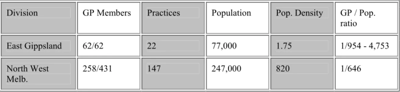
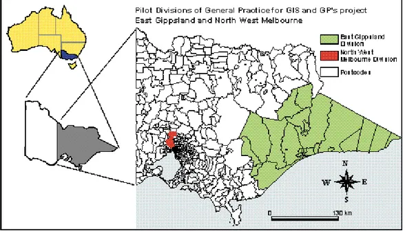
(3) Services) committed funds to develop and implement a prototype GIS as a tool for the purposes of planning, education and research in relation to the health needs and health status of the Divisions’ population groups.. Project Team The Research Team involved in this Project includes the Centre for Community Child Health & Ambulatory Paediatrics (Royal Children's Hospital, Melbourne), the Department of Geomatics, University of Melbourne, and the National Key Centre for Social Applications of GIS, University of Adelaide. The project also received support from Land Victoria. The Centre for Community Child Health plays a national role in child health education and research across the range of health professions including general practice. The Department of Geomatics conducts education and research on a wide variety of GIS topics and plays an important role on the diffusion of GIS technology, assisted by a Victorian state government agency, Land Victoria which deals with geospatial policy and geospatial data sets. The National Key Centre for Social Applications of GIS, as their name suggests, has expertise in the application of GIS technologies to social and community planning programs. Instrumental partners involved in the project have been the two Divisions of General Practice for whom the project was developed. One Division is in North West Melbourne, an inner metropolitan area of Victoria’s capital city (figure 1). The second Division is located in a rural, coastal area in the south east of Victoria (in South Eastern Australia) in an area which equates to 12.5% of the state and where the population lives mainly in two major town centres (Hind & Hind 1998). North West Melbourne Division comprises 234 GPs of the 436 known to be practising GPs in that geographic area (Divisional membership is voluntary). The total population is 281,856 persons (1996 Australian Population and Housing Census Data) giving a GP-person ration of 1:646. The East Gippsland Division of General Practice is situated approximately 200-500 kms south-east of Melbourne. There is an average population ratio of 1:1679 in this Division, however due to the seasonal nature of the population, being a popular seaside vacation area, the ratio can vary from 1:954 to 1:4753 (Hind & Hind 1998) (table 1). Division. GP Members. Practices. Population. Pop. Density. GP / Pop. ratio. East Gippsland. 62/62. 22. 77,000. 1.75. 1/954 - 4,753. North West Melb.. 258/431. 147. 247,000. 820. 1/646. Table 1. Some indicators in North West Melbourne and East Gippsland Divisions of general Practice.
(4) Fig. 1. Pilot Divisions of General Practice.. General Practice Data and Outcomes Based Funding Eighty-six percent of the Australian population visits their doctor at least once a year, providing GPs with a principal role in the management of health concerns and consequently overall resource spending, including patterns of prescribing, uptake of preventive activities, uptake of other health services, the use of diagnostic imaging services and referrals to other specialists (Commonwealth Dept. Health & Family Services 1996). Divisions have been identified as an organisational structure, which is likely to effect improvement to health outcomes, and with a system-wide orientation to the adoption of outcomes, the setting of General Practice is an important one. Funding is made available for GP members of divisions to become involved in cooperative activities. A proportion of the Divisions’ income, however, is tagged according to their ability to demonstrate improvement in pre-agreed health outcomes of their populations. These outcomes are therefore information dependent. In terms of the role of routine data collection in the General Practice sector, the collection of morbidity data or practice patterns is currently not at all systematic. In Australia, in contrast to the U.K. and the U.S., there is an unfortunate lack of reliable morbidity data, which is collected at a population level and inclusive of any useful geospatial variables such as address, postcode, or statistical local areas. The choice is up to the individual practice on how or when they computerise their businesses, what data they collect, and how the information is used. To date, there has also been a lack of information on the outcomes of their activities as general practitioners which can partially be attributed to a lack of data collections systems and technological approaches to advancing information for a health outcomes decision making system. The development of this GIS seeks to redress some of the past limitations.. Project methodology.
(5) Briefly, the phases of the project consisted of establishing information needs, collection of data, system implementation, system delivery and evaluation. The methods and data sources for this project were closely aligned to the needs and future directions of the Divisions in their provision of clinical and preventive general practice services to their communities. Data collection The information needs of the two Divisions were established early, relative to the scope of the project and dependant on whether the data collections had a geospatial variable included within their data structure. Divisions identified the important areas of decision making, and these were linked to potential sources of available data. Some of this data is routinely collected by leading health agencies at national and state levels, while more local data needed to be gathered to provide a more complete picture. The digital map base of Victoria was provided by Land Victoria, the state government’s Department of Natural Resources and Environment. Demographic data came from Australian Bureau of Statistics (ABS) 1996 Population and Housing Census (country of origin, age, sex, income). Hospital admissions data was obtained from the state government’s hospital inpatient database (Victorian Inpatient Minimum Dataset, Victorian Department of Human Services). One of the most important priorities that Divisions of General Practice identified is immunisation coverage of young children, so coverage rates data came from a national population-based immunisation register (Australian Commonwealth Immunisation Registry, Health Insurance Commission, Australian Capital Territory).. Redressing the gaps in data availability Data was attainable on the population within the Divisions, but very little on the general practices themselves. This gap in data availability was partially redressed through questionnaires administered to each practice location. These questionnaires collected information relating to types of data held by general practices (electronic or paper based patient health records, availability of data summaries, knowledge of peak service times) and questions related to building a picture of the size of the practice by staff and patients seen, other co-located services, and other relevant data such as distance patients travelled to see their doctor.. Developing the System for Divisional Implementation The increasing emergence and widespread uptake of communication technologies in Australia was considered in the preparation for presentation of the GIS prototype to the Divisions. The team chose the Internet as the optimum media for the delivery and placement of the product. The GIS software ArcExplorer, provided by ESRI (http://www.esri.com) was selected as the software of choice based on its ability to perform elementary queries and obtain good quality display, desirable by the Divisions. Whilst this package doesn’t include the full analytical capabilities of other GIS packages, the selection of user-friendly software was a high priority. As the pilot divisions already have access to the Internet, software costs and the acquisition of additional hardware were eliminated. Consideration needed to be given to posting.
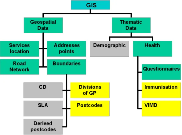
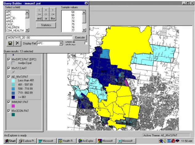
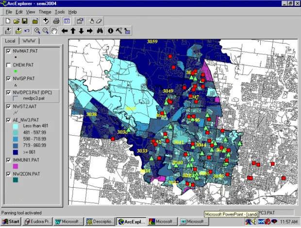
(6) sensitive data from a project such as this, an aspect not unique to the use of the Internet. The web site (http://www.sli.unimelb.edu.au/gdv/gdv_health.html) restricts the confidential information to the pilot Divisions only, through the provision of access passwords. Figure 2 shows the model of integration of data bases in the GIS for GPs. All the data bases have been integrated into the system through common GIS operations such as tabular linking and address geocoding. Common identifiers such postcode boundaries and divisional boundaries permit the integration of all data into the system.. Fig. 2. Model of integration of data bases in the GIS for GPs project.. Project Outcomes Queries The possibilities for making queries and analysis are many. An example of a two-stage query is as follows: 1. ‘Show me the postcode areas in North West Melbourne Division where less than 80% of children between fifteen and twenty months of age are fully immunised’ (corresponding to the Australian Childhood Immunisation Schedule). The postcodes are both tabled and highlighted (figure 3):.
(7) 2. Fig. 3. Postcode areas in North West Melbourne Division where less than 80% of children between fifteen and twenty months of age are fully immunised. 3. ‘What immunisation providers are located in these postcodes?’. This reveals all family doctors, community health centres and maternal and child health nurses in the area who may be targeted for inclusion in immunisation initiatives (figure 4). Ideally, it would be simpler to integrate the data if all data sets had boundaries that articulated. Since this is not the case, a new query must be formulated for each of the themes. Spatial queries can be performed using the information tool (i ) in each of the layers..
(8) Fig. 4. Immunisation providers located in the postcodes with low immunisation rates.. Training and Evaluation The end stages of the project involved the provision of training and education to the two Divisions since Divisional staff have no prior experience with GIS or geo-spatial data. The sessions were based on some basic theory and practical sessions on the use of spatial information systems, geospatial data, introduction to Arc Explorer, basic querying skills and spatial data visualization. Whilst it is important to consider that the technology is being adopted by the organisation rather than individual users consideration needs to be given to the variation in the ability and familiarity of divisional staff with information technology and whether or not this exerts an influence over how they utilise the database. Divisional staff will utilise the GIS according to their job role within the organisation, for example a program planner, administration support and executive staff may make varying uses of the database. An evaluation of the ways in which the technology is subsequently adapted and reinvented to meet divisional needs is planned for the first 12-month period following implementation. The time line of the evaluation takes critical planning processes of the Divisions into consideration and ensures that the evaluation occurs within the lifespan of the data in the GIS. Qualitative and quantitative data collection methods will be used, for example in-depth interviews with staff, and systematic review of written documents and administrative records, which incorporate data or utilise capabilities originating from the GIS. With two contrasting Divisions in diverse settings, it would not be unexpected that the outcomes of adopting the GIS technology could be quite different even within these similar organisations carrying out similar functions (Masser 1997 www.shef.ac.uk/academic/D-H/gis). Of particular interest will be those opportunities.
(9) facilitated by the presence of a GIS that enables Divisions to do new things that add value or would not have been possible without a GIS, so commonly absent from most evaluation of GIS (Rushton 1997 GISDATA http://www.shef.ac.uk/uni/academic/DH/gis/healabs.html) As the adoption of GIS in the primary health sector is a relatively recent phenomenon, there are relatively few examples of adoption of the technology, and consequently a limited amount of experience to support claims that GIS implementation means improved information processing and more informed decision making. Results of the evaluation will be used to inform the development of future information-based decision support technology within the Divisions of General Practice environment.. Conclusions The GIS for GPs study was undertaken to develop a methodology for the provision of a GIS to a particular groups of providers of primary health care, and has been successful in achieving its aims. The research has highlighted a number of constraints in the development of a GIS for the health sector, the major challenge being the variety of geographic classifications that have been used for health data over the last decade including numerous versions of regional and subregional classifications used by national and state authorities. There are also widespread differences in data collection methods, data quality and data access. A relatively underdeveloped technological infrastructure within General Practice in Victoria minimises access to the Internet and information systems in general, though current trends in the uptake of computers in general practice will go some way to overcoming this constraint. The Victorian Government's policy to make available geospatial data to all Victorians (Strategic Plan, Victoria 21, 1997) details its intention to face the information age in the twenty-first century. Other initiatives in the State of Victoria this year include the Department of Human Services' (Victoria) commitment to drawing up a 'GIS for Health Strategy' to support spatial information systems and improvement of decision making by health planners (Catford 1998), and the development of an Australian Research Council funded project to develop a ‘GIS for Health Research Strategy’. Until recently, GIS in health has been reliant on quantification methods of monitoring and measuring the population in the interests of improving health. Statistical surveys, epidemiological assessments, evaluations and health outcomes are currently central to influencing policy, planning, and resource allocation. If there is a desire to study the geography of health rather than the geography of disease (Gatrell & Loytonnen 1996), consideration needs also to be given to ways in which qualitative health data which includes lay perceptions of health and illness and the 'lived' or socially experienced dimension of health (Janes et al 1986), can be incorporated into a GIS framework. The GIS for GP prototype has been developed by a research team who is not the ultimate end user. The end users, the Divisional teams, have not previously had experience in the use of information systems within their decision making systems. They are also under a great deal of pressure to change how they make decisions, and what techniques they employ to assist them in their decision making. The final.
(10) evaluation of the project will be testimony to the ultimate success of the GIS for General Practice product, but the outcomes of the actual creation process are already tangible. It is hoped that these initiatives will go some way to furthering the utilisation of GIS technology in the health sector in Australian states and territories.. Acknowledgments The authors would like to thank the Department of Human Services, Victoria, the National Key Centre for Social Applications of GIS (University of Adelaide) and Land Victoria for their collaboration with this project.. References Catford, J. (1998), 'Geographic Information Systems and Health', presented at the Second Symposium on G.I.S. and Health, , ‘Developments in the Application of Geographic Information Systems Within the Health Sector’, Wednesday June 10th, http://www.sli.unimelb.edu.au/HealthGIS98/presentations. Colledge, M., Maxwell, H., Parker, R., Morse, D. (1996), 'Geographical Information Systems in General Practice: A New Tool for Needs Assessment', Journal of Informatics in Primary Care, March, 7-11. Commonwealth Department of Health and Family Services (1996), 'General Practice in Australia: 1996', General Practice Branch, Australia. Gattrell, A.C. & Bailey, T.C. (1996), Interactive Spatial Data Analysis in medical Geography, Social Science Medicine, vol. 2, No. 6, pp 843 - 855. Glover, J. (1998) ‘GIS for Health in Australia without the building blocks; are we missing the point?’ presented at the Second Symposium on G.I.S. and Health, ‘Developments in the Application of Geographic Information Systems Within the Health Sector’, Wednesday June 10th, http://www.sli.unimelb.edu.au/HealthGIS98/presentations. HealthWIZ, Prometheus Information Pty. Ltd., http://www.prometheus.com.au. Hind, J. & Hind, J (1998), The Health Status of People in the East Gippsland Region: A Report to the East Gippsland Division of General Practice, May. Hugo, G. (1995), ‘Locational Disadvantage: Development of a Data Model to Support Government Decision Making’, prepared for the Social Justice Research Program Into Locational Disadvantage and the Office of Geographic Data Coordination, Department of Premier and Cabinet, Victoria, March. Land Victoria, 1997. Strategic Plan Victoria 21. Land Victoria, Department of Natural Resources and Environment. Document for diffusion. Rumbold, G. (1998), ‘Two Examples of the Application of Geographic Information Systems in Drug Research’ presented at the Second Symposium on G.I.S. and Health, ‘Developments in the Application of Geographic Information Systems Within the Health Sector’ Wednesday June 10th, http://www.sli.unimelb.edu.au/HealthGIS98/presentations.
(11)
Figure
+2
Documento similar
The expansionary monetary policy measures have had a negative impact on net interest margins both via the reduction in interest rates and –less powerfully- the flattening of the
Jointly estimate this entry game with several outcome equations (fees/rates, credit limits) for bank accounts, credit cards and lines of credit. Use simulation methods to
In our sample, 2890 deals were issued by less reputable underwriters (i.e. a weighted syndication underwriting reputation share below the share of the 7 th largest underwriter
Calendar Describe important dates and moments in this case (table or illustration). Asses: 1) the diagnostic methods used (e.g. physical examination, analyses, imaging
The aim of this study was to evaluate retrospectively the sensitivity of three different serological tests used in real clinical practice for the screening and diagnosis of
For the C–O condition in the narrative setting, children and adults chose the target complete situation almost all the time, but for the same pair in the narrative setting, both
The emphasis was discussed on the ways dental information can be used for dentistry to specifically impact oral health care delivery.. The birth of telemedicine as a
The Dwellers in the Garden of Allah 109... The Dwellers in the Garden of Allah
