Secretariat
of the Convention on
Biological Diversity
22
/
1
GUIDELINES FOR THE
RAPID ECOLOGICAL ASSESSMENT OF
BIODIVERSITY IN INLAND WATER,
COASTAL AND MARINE AREAS
CBD Technical Series No. 22 / Ramsar Technical Report No. 1GUIDELINES FOR THE RAPID ECOLOGICAL ASSESSMENT OF
BIODIVERSITY IN INLAND WATER, COASTAL AND MARINE AREAS
Published jointly by the Secretariat of the Convention on Biological Diversity and the Secretariat of the Convention on Wetlands (Ramsar, Iran, 1971) ISBN:
Copyright © 2006, Secretariat of the Convention on Biological Diversity; © 2006, Ramsar Convention Secretariat. The designations employed and the presentation of material in this publication do not imply the expression of any opinion whatsoever on the part of the Secretariat of the Convention on Biological Diversity or the Secretariat of the Ramsar Convention concerning the legal status of any country, territory, city or area or of its authorities, or concerning the delimitation of its fron-tiers or boundaries.
The views expressed in this publication are those of the contributors authors and do not necessarily reflect those of the Secretariat of the Convention on Biological Diversity or the Secretariat of the Ramsar Convention.
This publication may be reproduced for educational or non-profit purposes without special permission from the copyright holders, provided acknowledgement of the source is made. The Secretariats of the Convention on Biological Diversity and the Ramsar Convention would appreciate receiving a copy of any publications that use this document as a source.
Ramsar Technical Reports are designed to publish, chiefly through electronic media, technical notes, reviews and reports on wetland ecology, conservation, wise use and management, as an enhanced information support service to Contracting Parties and the wider wetland community in support of implementation of the Ramsar Convention. In particular, the series includes the detailed technical background reviews and reports prepared by the Convention’s Scientific and Technical Review Panel (STRP), at the request of Contracting Parties, and which would previously have been made available in most instances only as “Information Papers” for a Conference of the Parties (COP). This is designed to ensure increased and longer-term accessibility of such documents. Other reports not originating from COP requests to the STRP, but which are considered by the STRP to provide information relevant to supporting implementation of the Convention, may be proposed for inclusion in the series. All Ramsar Technical Reports are peer-reviewed by the members and observers appointed to the STRP.
Ramsar Technical Reports and the CBD Technical Series are published in English in electronic (.pdf) format. When resources permit, the reports will be published also in the other official languages of both Conventions and in printed form. A version of the technical section of this document was adopted at the ninth meeting of the Contracting Parties to the Ramsar Convention and is available in both French and Spanish as resolution IX.1.annex.Ei at http://www.ramsar.org/res/key_res_ix_index_e.htm Photo Credits:
S.Davis/UNEP /Alpha Presse; Fritz Polking /Alpha Presse; Ngoc Thai Dang/UNEP /Alpha Presse Meking River; and Jim Wark /Alpha Presse
Citation:
Guidelines for the rapid ecological assessment of biodiversity in inland water, coastal and marine areas. Secretariat of the Convention on Biological Diversity, Montreal, Canada, CBD Technical Series no. 22 and the Secretariat of the Ramsar Convention, Gland, Switzerland, Ramsar Technical Report no. 1.
For further information please contact:
Secretariat of the Convention on Biological Diversity
World Trade Centre, 413 St. Jacques, Suite 800, Montreal, Quebec, Canada H2Y 1N9 Phone: 1 (514) 288 2220
Fax: 1 (514) 288 6588 E-mail: [email protected] Website: http://www.biodiv.org Secretariat of the Ramsar Convention rue Mauvernay, 28
1196 Gland Switzerland
Contents
TABLE OF CONTENTS
Foreword ... iii
Acknowledgements ... v
EXECUTIVE SUMMARY... 6
1. INTRODUCTION ... ... 10
2. SCOPE AND APPROACH OF THESE RAPID ASSESSMENT GUIDELINES ... 11
3. WHAT IS “RAPID ASSESSMENT”? ... 12
4. ISSUES TO CONSIDER WHEN DESIGNING A WETLAND RAPID ASSESSMENT ... 12
5. WHEN IS RAPID ASSESSMENT APPROPRIATE? ... 14
5.1 Addressing socio-economic and cultural features of biodiversity ... 15
5.2 Assessing threats to wetland biodiversity ... 16
5.3 Rapid assessment in relation to monitoring ... 16
5.4 Rapid assessment and trends in biological diversity ... 16
5.5 Seasonality ... 16
5.6 Special considerations relating to small island states ... 17
6. A CONCEPTUAL FRAMEWORK FOR RAPID ASSESSMENT ... 17
6.1 Choosing rapid assessment types and outputs for different purposes ... 21
Purpose... 21
Assessment types... 23
7. DESIGN CONSIDERATIONS ... 28
7.1 Resources ... 28
Time ... 29
Money ... 29
Expertise ... 29
7.2 Scope ... 30
Taxonomic scope ... 30
Geographic scope ... 30
Site selection ... 31
7.3 Sampling and data analysis ... 31
8. REFERENCES ... 33
Appendix 1 Assessment analysis methods and indices ... 36
Appendix 2 Sampling methods for wetland habitats, features and different wetland-dependent taxa ... 42
Foreword
FOREWORD
According to the Millennium Ecosystem Assessment reports, inland water, coastal and near-shore marine ecosystems include the most threatened of the world’s main habitat types. Demands placed by people on natural resources in and around these wetlands, particularly the unsustainable use of water resources, are consequently resulting in rapid changes, especially declines, in biodiversity. This in turn results in significantly reduced capacity of the ecosystems to provide the important services that are nec-essary for people, in particular to the poor and vulnerable communities in less developed countries, as well as the planet. Sustaining and rehabilitating, where necessary, these ecosystem services is a key requirement for the achievement of human development goals and targets.
Despite the tremendous importance of these ecosystems to human welfare, our knowledge of the bio-diversity within them is fragmentary at best. There are many reasons for these knowledge gaps. The sig-nificant contribution of these ecosystems to human wellbeing has not always been matched by invest-ment in research and manageinvest-ment. They also support a very large diversity of life. Some habitats remain difficult to access and sample. The comprehensive assessment of these biological resources requires significant and long-term effort. We should not forget that, for some habitats in some regions, scientists have already improved our understanding, despite wide-ranging constraints. Neither should we ignore the role of local communities, who are already armed with considerable understanding of these environments.
We need more information to be able to manage these systems better. The urgency of biodiversity decline means that such information needs to be obtained quickly, using credible methods applied effi-ciently and effectively. Achieving a significant reduction in the rate of loss of biodiversity by 2010 requires substantial efforts and must be accompanied by scientifically valid approaches to the evaluation of our progress. For given locations or ecosystems we need to know better what biodiversity is there, its status, function and value and whether our efforts are contributing to improving things.
It is primarily for this reason that these guidelines have been produced. They present a suite of options for rapidly undertaking assessments in different habitat types and under differing technical capacity constraints. They include approaches for obtaining data for inventories, assessment and monitoring. They focus on biological assessments, mainly at the species level but also at the ecosystem level. The assessment of the social, economic and cultural values of the biodiversity of these ecosystems is equally, if not more, important. Therefore a complementary set of guidelines is being produced to assist with those aspects.
These guidelines have been produced through a lengthy and detailed consultative process. But no guid-ance can be totally comprehensive. We present them as a tool to assist those that need help to try to obtain better information effectively. The guidelines should be considered in the context of available local capacity and the availability of other sources of assistance with obtaining information. In particu-lar, we stress that they should be used, if necessary, as a means to supplement information available through traditional and local knowledge.
Foreword
We are particularly proud to present this document as a joint effort between the Convention on Biological Diversity and the Convention on Wetlands (Ramsar Convention). The Ramsar Convention is the lead implementation partner for wetlands for the CBD. The background to the collaboration between our two conventions in preparing these guidelines is explained in the text. Here we acknowl-edge the fruits of this collaboration in the best way we can – through a joint publication.
Ahmed Djoghlaf
Executive Secretary
Convention on Biological Diversity
Peter Bridgewater
Secretary General
Acknowledgements
ACKNOWLEDGEMENTS
Draft guidelines for inland waters were originally developed by Conservation International and further refined at a workshop attended by Fatouma Ali Abdallah (Comoros), Leroy Mc.Gregor Ambroise (Saint Lucia), Geoffrey Cowan (South Africa), Joseph M. Culp (Canada),Hederick R. Dankwa (Ghana), Maria Hilda Cuadros Dulanto (Peru), Teresita Borges Hernández (Cuba), Ilja Krno (Slovak Republic),Ryszard Kornijów (Poland), Antanas Kontautas (Lithuania), Lionel Michael (Antigua and Barbuda), Rudy Vannevel (Belgium), Andrew Fraser (UNEP GEMS/Water), Matthias Halwart (FAO), Wafa A. Hosn (UQAM), Mary Lammert Khoury (The Nature Conservancy), Jean-Christophe Vié (IUCN), Leeanne E. Alonso (Conservation International), Nick Davidson (Ramsar Convention) and Robert Höft, Jo Mulongoy and Marjo Vierros (CBD Secretariat).
Draft guidelines for marine and coastal areas, based upon the format for inland waters, were originally developed through an electronic discussion forum with inputs from representatives of the following organisations or assessments: The Global International Waters Assessment (GIWA); Marine Rapid Assessment Programme of Conservation International; Atlantic and Gulf Rapid Reef Assessment (AGRRA); Ramsar Convention; UNEP-WCMC; Northwest Hawaiian Islands Rapid Reef Assessment (NOW-RAMP); The Intergovernmental Oceanographic Commission (IOC) of UNESCO; The Global Programme of Action for the Protection of the Marine Environment from Land-based Activities (GPA); Land-Ocean Interactions in the Coastal Zone (LOICZ); Reef Check; Reefs at Risk of the World Resources Institute; Coral Reef Degradation in the Indian Ocean (CORDIO); Arctic Assessment and Monitoring Programme; FAO Fisheries Division; the Convention for the Protection of the Marine Environment of the North-East Atlantic (OSPAR Convention); WWF; IUCN; Global Marine Assessment (GMA); Caribbean Environment Programme; South Pacific Environment Programme; the SPA protocol of the Mediterranean Action Plan; Eastern African Regional Seas Programme; Regional Coordinating Unit for East Asian Seas; and Regional Organization for the Protection of the Marine Environment (ROPME).
The draft guidelines were subsequently reviewed and improved by the Scientific and Technical Review Panel of the Ramsar Convention.
David Coates, Jo Mulongoy and Marjo Vierros (CBD Secretariat) and Max Finlayson, Nick Davidson and Dwight Peck (Ramsar STRP and Secretariat) edited this document.
Funding for the publication of the printed version of this document was provided by the Netherlands Government.
We are grateful to all for making this publication possible.
Ahmed Djoghlaf
Executive Secretary
Convention on Biological Diversity
Peter Bridgewater
Secretary General
GUIDELINES FOR THE RAPID ECOLOGICAL ASSESSMENT OF BIODIVERSITY IN INLAND WATER, COASTAL AND MARINE AREAS
EXECUTIVE SUMMARY
These guidelines have been produced through an extensive consultation process involving inputs from a large number of specialists. They are prepared in response to requests of the Conference of the Parties to both the Convention on Biological Diversity (CBD) and Ramsar Convention. They are designed as a suite of optional tools to assist those with urgent need and/or limited capacity and resources to under-take, where necessary, rapid inventories, assessment and monitoring of the biological diversity of inland water, coastal and near-shore marine ecosystems. They focus largely at species level considerations (i.e., assessments of taxa) but also include some tools relevant for assessment at the habitat/ecosystem level. Guidelines to assess the socioeconomic and cultural aspects of the value of biodiversity in these ecosys-tems are being developed to complement the current methods and will be published separately. The guidelines should be seen as additional means of obtaining information to that already held through existing and local knowledge which should be assessed, and used, as the first step in any survey.
Rapid assessment is defined here as a synoptic assessment, which is often undertaken as a matter of urgency, in the shortest timeframe possible to produce reliable and applicable results for its designed purpose. Given the importance of often limited inland wetlands in small island States, the importance of their coastal and marine systems and limited capacity, rapid assessment methods are particularly valuable in these States.
Issues to take into account when designing any rapid assessment include: the type of rapid assessment (they range from desk-top studies to full blown field surveys); the rapidity of stages (design/preparation, implementation and reporting); inventory, assessment or monitoring (which require different approaches); speed versus expense; spatial scale; compilation of existing data; creating audit trails to data; reliability; and, dissemination of results.
Rapid assessment is one of a suite of tools and approaches that Parties can use for assessing wetlands. They are not suitable for collecting all necessary types of information and often help identify where knowledge gaps are that require more detailed approaches. As far as possible, assessments should include identifying and quantify threat categories to biodiversity. Therefore, a checklist to cover this aspect is included.
Rapid assessment designed to assess trends in biological diversity implies that more than one repeat sur-vey will be required. Seasonality aspects of wetlands are particularly difficult to capture using short-term approaches. The timing of a rapid assessment in relation to seasonality is a critically important issue to take into account.
An overall conceptual framework for rapid assessment is presented starting from the definition of pur-pose to the dissemination of results. Intermediate steps include: the review of existing knowledge (including traditional and local knowledge); identification of information gaps; study design; imple-mentation and review of the approach; establishment of databases and creating metadata files; and, analysis and report production. Different purposes or objectives for information require different approaches. Assessment types include baseline inventory, species-specific assessment, change assess-ment, indicator assessment and resource assessment.
GUIDELINES FOR THE RAPID ECOLOGICAL ASSESSMENT OF BIODIVERSITY IN INLAND WATER, COASTAL AND MARINE AREAS
Design should consider: resources available, including time, money and expertise; scope, including tax-onomic and geographic scope and site selection; sampling data and analysis, including identification of what data are required, how to collect it, how much to collect, how to enter it into a database, analyse it and integrate it into a report.
GUIDELINES FOR THE RAPID ECOLOGICAL ASSESSMENT OF BIODIVERSITY IN INLAND WATER, COASTAL AND MARINE AREAS
1. INTRODUCTION
The Conference of the Parties (COP) to the Convention on Biological Diversity (CBD), in decision IV/4, referring to its programme of work on the biological diversity of inland water ecosystems (for which the Ramsar Convention acts as the lead implementation partner), requested the development and dissemina-tion of regional guidelines for rapid assessment of inland water biological diversity for different types of inland water ecosystems. Similarly, recommendation VI/5 of the Subsidiary Body on Scientific, Technical and Technological Advice (SBSTTA) of the CBD requested “development of methodologies . . . for scien-tific assessments, including those relating to marine and coastal biological diversity.” In parallel, the Ramsar Convention’s Strategic Plan 2003-2008 (Action 1.2.3) requests its Scientific and Technical Review Panel (STRP), Ramsar Secretariat and Secretariat of the CBD to “develop guidelines for rapid assessment of wetland biodiversity and functions and for monitoring change in ecological character, including the use of indicators, for both inland and coastal and marine ecosystems, for consideration by COP9”.
The CBD guidance for inland waters was originally drafted by Conservation International and further developed by an expert meeting convened jointly by the CBD and Ramsar Secretariats and involving both CBD and Ramsar experts nominated by national focal points. The guidance is specifically intended to meet the needs of both CBD and Ramsar Convention, in line with the CBD/Ramsar 3rd Joint Work Plan. Marine and coastal guidance, developed through an electronic working group, was modelled on that for inland waters, and its approach and general structure is consistent with the inland waters guidance.
The original CBD guidelines were made available to the eighth meeting of the CBD’s SBSTTA and are available for download from the CBD Web site [http://www.biodiv.org/convention/ sbstta.asp] as UNEP/CBD/SBSTTA/8/INF/5 (inland waters) and UNEP/CBD/SBSTTA/8/INF/13 (marine and coastal), plus a short supplementary marine and coastal paper (UNEP/CBD/SBSTTA/9/INF/25).
Concerning the inland waters guidelines, CBD COP-7 in 2004 (decision VII/4) welcomed the guidelines, recognized their usefulness for creating baseline or reference data sets for inland water ecosystems of differ-ent types and for addressing the serious gaps that exist in knowledge of taxonomy, distribution, and con-servation status of freshwater species, and invited its Parties, other Governments and relevant organizations to use and promote the application of the guidelines, in particular in the circumstances of small island devel-oping states and in the territories of states in which inland water ecosystems suffer from ecological disaster.
In 2004, the Scientific and Technical Review Panel (STRP) of the Ramsar Convention considered how best to incorporate the various components of the CBD rapid assessment guidelines into the suite of Ramsar guid-ance on inventory, assessment and monitoring. The Panel determined that, given that the Ramsar definition of “wetlands” covers both inland waters and marine and coastal systems, it is most appropriate for its applica-tion by Ramsar Contracting Parties to make the guidance available as a single consolidated guidance docu-ment, with the relevant material from all three of the aforementioned CBD information papers merged. These present guidelines are thus a compiled and edited version of the CBD materials, taking into account the needs of both Conventions, prepared jointly by the Ramsar Secretariat, the Ramsar STRP and the CBD Secretariat.
The two Conventions use different terminology. Ramsar refers to “wetlands” whereas the CBD refers to inland water, coastal and marine ecosystems. For the purposes of this document these terms are inter-changeable, as appropriate.
GUIDELINES FOR THE RAPID ECOLOGICAL ASSESSMENT OF BIODIVERSITY IN INLAND WATER, COASTAL AND MARINE AREAS
2. SCOPE AND APPROACH OF THESE RAPID ASSESSMENT GUIDELINES
The guidance provided here refers to “biological” assessments of biodiversity largely at the species and community level. However, some reference is also made to tools which will assist in the assessment of wetland ecosystems. Decision VII/4 (paragraph 21) of the CBD notes this focus and the need for addi-tional guidance for the further assessment of ecosystem level aspects and economic, social and cultural aspects of such biodiversity. In terms of promoting increased emphasis on the need for the conserva-tion and sustainable use of these ecosystems (wetlands) the latter guidance is arguably even more impor-tant. Work to develop guidance on the valuation of economic, social and cultural aspects of wetlands has already been partially completed and this guidance will be published by the Ramsar Secretariat jointly with the CBD Secretariat during 2006 in the Ramsar Technical Report series in order to achieve its wide dissemination (see also document UNEP/CBD/COP/8/INF/XX ).
Information is also included in these guidelines on rapid assessment methodologies for assessing change in coastal ecosystems in the aftermath of natural disasters. These methodologies have been developed to assist in the assessment of the impacts to coastal ecosystems of the Indian Ocean tsunami of December 2004.
The present rapid assessment guidelines draw heavily on, and are consistent with, the general guidelines for selecting appropriate wetland inventory methods in Ramsar’s “A Framework for Wetland Inventory” (COP8 Resolution VIII.6). As is set out in the rapid assessment guidelines, rapid assessment methods can be applied for a number of types and purposes of wetland inventory and assessment. Hence this guidance is relevant to the implementation of a number of aspects of the Ramsar “Integrated Framework for Wetland Inventory, Assessment and Monitoring” (COP9 Resolution IX.1 Annex E).
The guidelines are designed to serve the needs of Contracting Parties of both the Ramsar Convention and the Convention on Biological Diversity. Rapid assessment methods are placed in the context of more comprehensive inventory, assessment and monitoring programmes, and a conceptual framework for their design and implementation is included. They are intended to provide advice and technical guidance that is useful to wide range of Parties with different circumstances, including geographic size, wetland types, and institutional capacities.
The guidelines stress the importance of clearly establishing the purpose as the basis for design and implementation of the assessment in each case. They also emphasize that before deciding on whether a new field survey using rapid assessment methods is necessary, a review of existing knowledge and infor-mation, including information held by local communities, should be undertaken as the first priority. Proceeding with assessments that ignore the significant depth of knowledge that local communities have is not only a significant potential waste of resources but also undermines the principles of both Conventions and is therefore strongly discouraged.
Subsequent steps are then presented in the form of a “decision tree” to facilitate the selection of appro-priate methods to meet the purpose of the assessment. An indication of the categories of information which can be acquired through each of the rapid assessment methods is provided. Summary informa-tion on a range of appropriate and available methods suitable for each rapid assessment purpose is included, as is information on a range of different data analysis tools.
GUIDELINES FOR THE RAPID ECOLOGICAL ASSESSMENT OF BIODIVERSITY IN INLAND WATER, COASTAL AND MARINE AREAS
3. WHAT IS “RAPID ASSESSMENT”?
Rapid assessment, for the purpose of this guidance, is defined as: “a synoptic assessment, which is often undertaken as a matter of urgency, in the shortest timeframe possible to produce reliable and applica-ble results for its defined purpose”.
It is important to note that rapid assessment methods for wetlands are not generally designed to take into account temporal variance, such as seasonality, in ecosystems. However, some rapid assessment methods can be (and are) used in repeat surveys as elements of an integrated monitoring programme to address such temporal variance.
Rapid assessment techniques are particularly relevant to the species level of biological diversity, and the present guidance focuses on assessments at that level. Certain other rapid assessment methods, includ-ing remote sensinclud-ing techniques, can be applicable to the ecosystem/wetland habitat level, particularly for rapid inventory assessments, and there is a need for further guidance on ecosystem-level rapid assess-ment methods. However, direct assessassess-ments at the genetic level of biological diversity do not generally lend themselves to “rapid” approaches. There are however alternative approaches to this problem, par-ticularly for inland water ecosystems, in that the likely genetic diversity of many taxa can be estimated from a knowledge of ecosystem diversity, functioning and geological and zoogeographic history.
The complex nature and variability of wetland ecosystems means that there is no single rapid assessment method that can be applied to the wide range of wetland types and for the variety of different purpos-es for which asspurpos-essments are undertaken. Furthermore, the extent of what is possible in a given case will depend on the resources and capacities available.
In the detailed guidance that follows, five specific purposes for undertaking rapid assessment are distin-guished: baseline inventory (called inventory assessment in the original CBD version of the guidelines), specific-species assessment, change assessment, indicator assessment, and economic resource assessment.
GUIDELINES FOR THE RAPID ECOLOGICAL ASSESSMENT OF BIODIVERSITY IN INLAND WATER, COASTAL AND MARINE AREAS
4. ISSUES TO CONSIDER WHEN DESIGNING A WETLAND RAPID ASSESSMENT
The following nine issues should be taken into account when designing any rapid assessment:
i. Types of rapid assessments. Rapid assessments can range from desk studies, expert group meet-ings and workshops to field surveys. They can include compiling existing expert knowledge and infor-mation, including traditional knowledge and inforinfor-mation, and field survey approaches.
ii. Assessments can be divided into three stages: design/preparation, implementation, and report-ing. “Rapidity” should apply to each of these stages. Rapid assessments provide the necessary results in the shortest practicable time, even though preparatory and planning work prior to the survey may be time-consuming. In some circumstances (for example, when taking seasonality into account) there may be a delay between the decision to undertake the assessment and carrying it out. In other cases (for example, in cases of disturbances and disasters), the assessment will be undertaken as a matter of urgency, and preparation time should be kept to a minimum.
iii. Inventory, assessment and monitoring. It is important to distinguish between inventory, assess-ment, and monitoring (see Box 1) when designing data-gathering exercises, as they require different types of information. Baseline wetland inventory provides the basis for guiding the development of appropriate assessment and monitoring. Wetland inventories repeated at intervals do not automatically constitute “monitoring”.
iv. Rapid assessment entails speed, but it can be expensive. Costs will increase particularly when assessing remote areas, large spatial scales, high topographic resolution, and/or a large number of types of features. Undertaking an assessment rapidly can mean a higher cost owing to the need, for example, to mobilize large field teams simultaneously and support them.
v. Spatial scale. Rapid assessments can be undertaken at a wide range of spatial scales. In general, a large-scale rapid assessment will consist of the application of a standard method to a larger number of localities or sampling stations.
vi. Compilation of existing data/access to data. Before determining whether further field-based assessment is required, it is an important first step to compile and assess as much relevant existing data and information as readily available. This part of the assessment should establish what data and infor-mation exists, and whether it is accessible. Data sources can include geographic inforinfor-mation systems (GIS) and remote sensing information sources, published and unpublished data, and traditional knowl-edge and information accessed through the contribution, as appropriate, of local and indigenous peo-ple. Such compilation should be used as a “gap analysis” to determine whether the purpose of the assess-ment can be satisfied from existing information or whether a new field survey is required.
vii. For any new data and information collected during a subsequent rapid assessment field survey, it is essential to create an audit trail to the data, including any specimens of biota collected, through the establishment of a proper metadata record for the assessment.
viii. Reliability of rapid assessment data. In all instances of rapid assessment of biological diversity
GUIDELINES FOR THE RAPID ECOLOGICAL ASSESSMENT OF BIODIVERSITY IN INLAND WATER, COASTAL AND MARINE AREAS
it is particularly important that all outputs and results include information on the confidence associat-ed with the findings. Where practical, error propagation through the analysis of data and information should be evaluated to provide an overall estimate of confidence in the final results of the assessment.
ix. Dissemination of results. A vital component of any rapid assessment is the fast, clear and open dissemination of its results to a range of stakeholders, decision-makers and local communities. It is essential to provide this information to each group in an appropriate form of presentation and appro-priate level of detail.
BOX 1. RAMSAR DEFINITIONS OF INVENTORY, ASSESSMENT AND MONITORING
Ramsar COP8 has adopted, in Resolution VIII.6, the following definitions of wetland invento-ry, assessment and monitoring:
Inventory: The collection and/or collation of core information for inland water management, including the provision of an information base for specific assessment and monitoring activities.
Assessment: The identification of the status of, and threats to, inland waters as a basis for the collection of more specific information through monitoring activities.
Monitoring: Collection of specific information for management purposes in response to hypotheses derived from assessment activities, and the use of these monitoring results for implementing management. (Note that the collection of time-series information that is not hypothesis-driven from wetland assessment should be termed surveillance rather than moni-toring, as outlined in Ramsar Resolution VI.1.)
5. WHEN IS RAPID ASSESSMENT APPROPRIATE?
Rapid assessment is one of a suite of tools and responses that Parties can use for assessing wetlands. Not all types of data and information needed for full wetland inventory and assessment can be collected through rapid assessment methods. However, it is generally possible to collect some initial information on all generally used inventory and assessment core data fields, although for some, rapid assessment can only yield preliminary results with a low level of confidence. Such types of data and information can, however, be used to identify where more detailed follow-up assessments may be needed if resources permit.
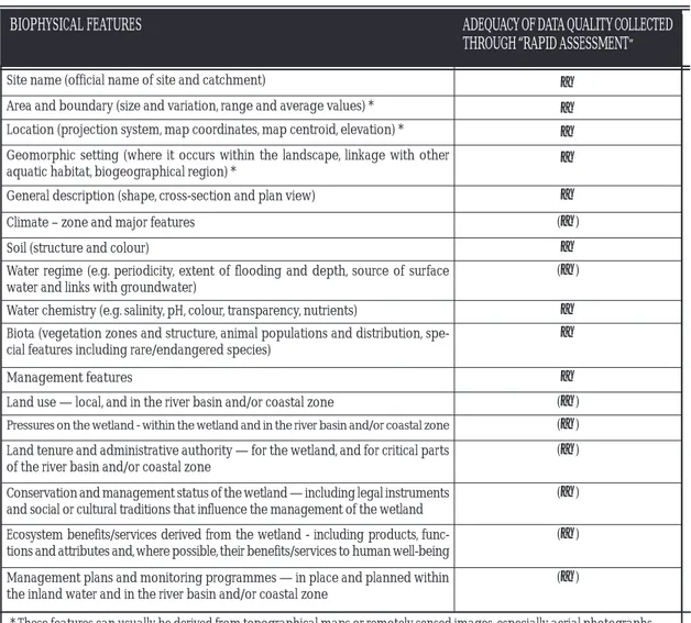
A summary of core data fields for inventory and assessment of biophysical and management features of wetlands, derived from that in Ramsar Resolution VIII.6, and the general quality of information for each which can be gathered through rapid assessment, is provided in Table 1.
Table 1. Adequacy of data and information quality which can at least partly be collected through “rapid assessment” field survey methods for wetland inventory and assessment core data fields for biophysical and management features of wetlands. (Derived from Ramsar Resolution VIII.6)
GUIDELINES FOR THE RAPID ECOLOGICAL ASSESSMENT OF BIODIVERSITY IN INLAND WATER, COASTAL AND MARINE AREAS
BIOPHYSICAL FEATURES ADEQUACY OF DATA QUALITY COLLECTED
THROUGH “RAPID ASSESSMENT”
Site name (official name of site and catchment) a
Area and boundary (size and variation, range and average values) * a
Location (projection system, map coordinates, map centroid, elevation) * a
Geomorphic setting (where it occurs within the landscape, linkage with other
aquatic habitat, biogeographical region) * a
General description (shape, cross-section and plan view) a
Climate – zone and major features (a)
Soil (structure and colour) a
Water regime (e.g. periodicity, extent of flooding and depth, source of surface water and links with groundwater)
(a)
Water chemistry (e.g. salinity, pH, colour, transparency, nutrients) a
Biota (vegetation zones and structure, animal populations and distribution, spe-cial features including rare/endangered species)
a
Management features a
Land use — local, and in the river basin and/or coastal zone (a)
Pressures on the wetland - within the wetland and in the river basin and/or coastal zone (a)
Land tenure and administrative authority — for the wetland, and for critical parts of the river basin and/or coastal zone
(a)
Conservation and management status of the wetland — including legal instruments and social or cultural traditions that influence the management of the wetland
(a)
Ecosystem benefits/services derived from the wetland - including products, func-tions and attributes and, where possible, their benefits/services to human well-being
(a)
Management plans and monitoring programmes — in place and planned within the inland water and in the river basin and/or coastal zone
(a)
* These features can usually be derived from topographical maps or remotely sensed images, especially aerial photographs.
GUIDELINES FOR THE RAPID ECOLOGICAL ASSESSMENT OF BIODIVERSITY IN INLAND WATER, COASTAL AND MARINE AREAS
5.1 ADDRESSING SOCIO-ECONOMIC AND CULTURAL FEATURES OF BIODIVERSITY
This guidance chiefly covers assessment of the biotic components of biological diversity. For many assessment purposes, it is also important to collect information on socio-economic and cultural features of biological diversity, although full economic valuation assessment is generally well outside the scope of rapid assessment. Nevertheless, as part of a rapid inventory assessment or risk assessment it may be useful to compile an initial indication of which socio-economic and cultural features are of relevance in the survey site. This can provide an indication of the likely changes to the natural resource base, and may be used to indicate which features should be the subject of more detailed follow-up assessment. The involvement of local communities in this process is particularly important.
For an indicative list of the socio-economic benefits/services of inland waters which are derived from biological diversity, see annex II of UNEP/CBD/SBSTTA/8/8/Add. 3. For further information on ecosys-tem benefits/services, see also the Millennium Ecosysecosys-tem Assessment (2005).
Cultural functions and values of inland waters (derived from Ramsar COP8 DOC. 15, Cultural aspects of wetlands) that should be taken into account include:
• Palaeontological and archaeological records; • Historic buildings and artefacts;
• Cultural landscapes;
• Traditional production and agro-ecosystems, e.g., ricefields, salinas, exploited estuaries; • Collective water and land management practices;
• Self-management practices, including customary rights and tenure; • Traditional techniques for exploiting wetland resources;
• Oral traditions; • Traditional knowledge;
• Religious aspects, beliefs and mythology;
• “The arts” – music, song, dance, painting, literature and cinema.
5.2 ASSESSING THREATS TO WETLAND BIODIVERSITY
In many rapid assessments it will not be possible fully to assess the threats to, or pressures on, biologi-cal diversity. Nevertheless, as for socio-economic and cultural features, it may be useful, for identifying where the focus of any further assessment may be needed, to make a provisional assessment of threat categories. For this purpose, a checklist of threat categories such as that being developed by the IUCN Species Survival Commission (SSC) as part of their Species Information Service (SIS) may be helpful (see http://www.iucn.org/themes/ssc/sis/authority.htm.)
5.3 RAPID ASSESSMENT IN RELATION TO MONITORING
assessment. Similarly, certain rapid assessment tools/methodologies can also be applied for longer term hypothesis-driven monitoring by repeated surveys. This can be a particularly valuable technique for addressing seasonality issues.
5.4 RAPID ASSESSMENT AND TRENDS IN BIOLOGICAL DIVERSITY
Rapid assessment designed to assess trends in biological diversity implies that more than one repeat sur-vey will be required. For gathering such information, regular time-series data may be necessary, and in such circumstances this can be considered as rapid assessment if each survey is undertaken using a rapid assessment method, although the resulting overall assessment will generally take shape over a longer time period.
5.5 SEASONALITY
Most rapid assessments involve a single “snapshot” survey of a locality. However, the seasonality of many wetlands and of the biota dependent upon them (for example, migratory species) means that surveys of different taxa may need to be made at different times of year. The timing of a rapid assessment in rela-tion to seasonality is a critically important issue to take into account if the assessment is to yield reliable results.
Other types of temporal variations in inland wetlands may also need to be taken into account, notably variations in flow regimes of different types of inland water ecosystems, which may include:
• perennial systems which experience surface flow throughout the year and do not cease to flow during droughts;
• seasonal systems which experience flow predictably during the annual wet season but may be dry for several months each year;
• episodic (periodic or intermittent) systems, which experience flow for an extended period but are not predictable or seasonal. These systems usually have flow contribution from rainfall as well as ground-water. At times, surface flow may occur in some segments only, with subsurface flow in other segments. The fauna can differ considerably depending on the duration of flow, colonization succession of differ-ent species, proximity of other water sources, and extdiffer-ent of time during which previous flow occurred; or
• ephemeral (short-lived) systems, which experience flow briefly and rarely and return to dry conditions in between. Their flow is usually sourced entirely from precipitation. Only aquatic biota able to com-plete their life cycles very rapidly (within a few days) are able to exploit such flow conditions.
5.6 SPECIAL CONSIDERATIONS RELATING TO SMALL ISLAND STATES
Given the importance of often limited inland wetlands in small island States, the importance of their coastal and marine systems, a general lack of information about their biodiversity, and limited institu-tional capacity, rapid assessment methods are particularly valuable in small island States. Priority pur-poses of assessment include:
• qualitative and quantitative aspects of water quality and quantity;
GUIDELINES FOR THE RAPID ECOLOGICAL ASSESSMENT OF BIODIVERSITY IN INLAND WATER, COASTAL AND MARINE AREAS
• causes of biodiversity loss and water pollution, including deforestation, pesticide flows, and other unsustainable exploitation; and
• pressures of unsustainable land uses (e.g., tourism, agriculture, fisheries, industry).
GUIDELINES FOR THE RAPID ECOLOGICAL ASSESSMENT OF BIODIVERSITY IN INLAND WATER, COASTAL AND MARINE AREAS
6. A CONCEPTUAL FRAMEWORK FOR RAPID ASSESSMENT
The overall conceptual framework presented in this document is derived from, and consistent with, the Ramsar Framework for Wetland Inventory (Resolution VIII.6). Certain modifications concerning the sequence and titling of its steps have been made to take account of the specific element of minimizing time scales which is inherent in rapid assessment.
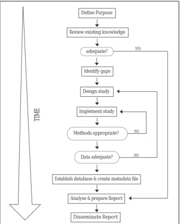
The process of applying the conceptual framework is summarized in Figure 1. Steps in the conceptual framework and guidance for the application of each step are listed in Table 2.
The framework is designed to provide guidance for planning and undertaking the initial wetland rapid assessment. Follow-up assessments, and those for new areas using a proven procedure and method, need not go through the entire process, although a review of methodology should be undertaken in relation to possible differences in local conditions such as different wetland ecosystem types.
In assessments undertaken in response to an emergency, e.g., a natural or human-induced disaster, the steps of the conceptual framework should be followed as far as possible. However, it is recognized that under such circumstances the need for a very rapid response can mean that shortcuts in applying the framework may be essential.
Figure 1. Summary of the key steps in applying the conceptual framework for rapid assessment (see Table 2 for further details).
Define Purpose
Review existing knowledge
Identify gaps
Design study
Implement study
Analyse & prepare Report Establish database & create metadata file
Disseminate Report YES
adequate?
Data adequate? Methods appropriate?
NO NO
TIME
GUIDELINES FOR THE RAPID ECOLOGICAL ASSESSMENT OF BIODIVERSITY IN INLAND WATER, COASTAL AND MARINE AREAS
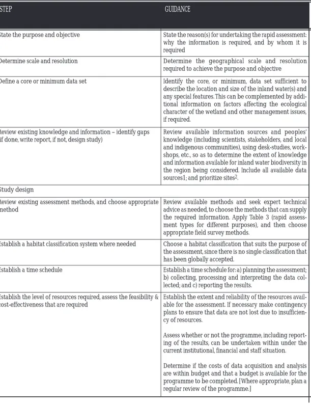
STEP GUIDANCE
State the purpose and objective State the reason(s) for undertaking the rapid assessment: why the information is required, and by whom it is required
Determine scale and resolution Determine the geographical scale and resolution
required to achieve the purpose and objective
Define a core or minimum data set Identify the core, or minimum, data set sufficient to describe the location and size of the inland water(s) and any special features. This can be complemented by addi-tional information on factors affecting the ecological character of the wetland and other management issues, if required.
Review existing knowledge and information – identify gaps (if done, write report, if not, design study)
Review available information sources and peoples’ knowledge (including scientists, stakeholders, and local and indigenous communities), using desk-studies, work-shops, etc., so as to determine the extent of knowledge and information available for inland water biodiversity in the region being considered. Include all available data sources1; and prioritize sites2.
Study design
Review existing assessment methods, and choose appropriate method
Review available methods and seek expert technical advice as needed, to choose the methods that can supply the required information. Apply Table 3 (rapid assess-ment types for different purposes), and then choose appropriate field survey methods.
Establish a habitat classification system where needed Choose a habitat classification that suits the purpose of the assessment, since there is no single classification that has been globally accepted.
Establish a time schedule Establish a time schedule for: a) planning the assessment; b) collecting, processing and interpreting the data col-lected; and c) reporting the results.
Establish the level of resources required, assess the feasibility & cost-effectiveness that are required
Establish the extent and reliability of the resources avail-able for the assessment. If necessary make contingency plans to ensure that data are not lost due to insufficien-cy of resources.
Assess whether or not the programme, including report-ing of the results, can be undertaken within under the current institutional, financial and staff situation.
Determine if the costs of data acquisition and analysis are within budget and that a budget is available for the programme to be completed. [Where appropriate, plan a regular review of the programme.]
GUIDELINES FOR THE RAPID ECOLOGICAL ASSESSMENT OF BIODIVERSITY IN INLAND WATER, COASTAL AND MARINE AREAS
STEP (CONT’D) GUIDANCE (CONT’D)
Establish a data management system and a specimen curating system
Establish clear protocols for collecting, recording and storing data, including archiving in electronic or hard-copy formats.
Ensure adequate specimen curating. This should enable future users to determine the source of the data, and its accuracy and reliability, and to access reference collections.
At this stage it is also necessary to identify suitable data analysis methods. All data analysis should be done by rig-orous and tested methods and all information docu-mented. The data management system should support, rather than constrain, the data analysis.
A meta-database should be used to: a) record informa-tion about the inventory datasets; and b) outline details of data custodianship and access by other users. Use existing international standards (refer to the Ramsar Wetland Inventory Framework – Resolution VIII.6)
Establish a reporting procedure Establish a procedure for interpreting and reporting all results in a timely and cost effective manner.
The reporting should be concise, indicate whether or not the objective has been achieved, and contain recom-mendations for management action, including whether further data or information is required.
Establish a review and evaluation process Establish a formal and open review process to ensure the effectiveness of all procedures, including reporting and, when required, supply information to adjust the assess-ment process.
Perform study and include continuous assessment of method-ology (go back and revise design if needed)
Undertake study method. Test and adjust the method and specialist equipment being used, assess the training needs for staff involved, and confirm the means of collat-ing, collectcollat-ing, entercollat-ing, analysing and interpreting the data. In particular, ensure that any remote sensing can be supported by appropriate “ground-truth” survey.
Data assessment and reporting (was purpose of the study achieved? If not, go back to step 3)
Undertake a formal and open review process to ensure the effectiveness of all procedures, including reporting and, when required, supply information to adjust or even terminate the program.
Results should be provided in appropriate styles and level of detail to, inter alia, local authorities, local commu-nities and other stakeholders, local and national decision-makers, donors and the scientific community.
1It is important to include identification not just of local data and information but also other relevant national and international
sources, which can provide supplementary data and information to underpin the rapid assessment (for example, the UNEP-GEMS/Water programme for water quality and quantity).
2IUCN has developed a methodology for prioritizing important sites for conservation of biodiversity of inland waters. See
GUIDELINES FOR THE RAPID ECOLOGICAL ASSESSMENT OF BIODIVERSITY IN INLAND WATER, COASTAL AND MARINE AREAS
6.1 CHOOSING RAPID ASSESSMENT TYPES AND OUTPUTS FOR DIFFERENT PURPOSES
The primary purpose of this guidance is to be a practical reference for deciding on appropriate meth-ods for the rapid assessment of wetland ecosystems. Table 3 provides a schematic guide to a number of available methods used for rapid assessment of wetland ecosystems. It is meant to enable the selection of appropriate assessment methods, based on a structured framework of selection criteria. These are organized in a progression of the most important factors of assessment of wetlands. Further informa-tion on rapid assessment data collecinforma-tion and analysis methods are provided in Appendices 1 and 2, and further consolidated information for wetlands on choices of rapid assessment methods in relation to different resource limitations (particularly of time, money and/or expertise) and the scope of the assess-ment will be provided in a forthcoming Ramsar Technical Report (separate detailed guidance for inland waters and for coastal and marine systems is also available in the CBD materials (UNEP/CBD/SBST-TA/8/INF/5 and UNEP/CBD/SBSTTA/8/INF/13 respectively)).
Choosing an appropriate method for the rapid assessment purpose should begin with the most basic and broad elements of an assessment, and then advance through progressively more selective criteria. Eventually a general framework of the necessary assessment should emerge, taking the amalgamated form defined by its purpose, output information, available resources, and scope. The idea is to meld informational parameters, like output and purpose, with logistical parameters such as time frame, avail-able funding, and geographical scope, in order to present a realistic assessment model and determine what methods are available for its implementation.
Defining the purpose is the first step of an assessment. Table 3 provides three general purposes corre-sponding to five specific purposes, which will determine the assessment type. The five specific ment types used in the decision tree are: baseline inventory, specific-species assessment, change assess-ment, indicator assessassess-ment, resource assessment. The assessment types are explained in detail below.
Once the purpose and assessment type have been determined, a step-wise approach should be taken through the more specific components of the assessment. These include the resource limitations and scope of the various elements of the assessment. This section begins with an appraisal of the resources available for the assessment. Time, money, and expertise are the critical resource components consid-ered in the tree; availability of or limitations on these resources will determine the scope and capacity of any rapid assessment. There are then six more specific parameters (taxa, geography, site selection, meth-ods, data collection, analysis) to consider in determining the scope of each of those relative to the resource limitations of the assessment. Variable combinations of resource limitations and scope criteria give shape to the assessment project.
Purpose
The approach starts with the supposition that any rapid wetland assessment ought to be performed with the overriding goals of conservation and wise use in mind. The methods used should augment knowl-edge and understanding in order to establish a baseline of wetland biological diversity, assess changes in, or the health of, wetland ecosystems, and support the sustainable use of the wetland resource. There are five specific reasons within this context to undertake a rapid assessment of wetlands. These cover the breadth of possible reasons for rapid assessment:
GUIDELINES FOR THE RAPID ECOLOGICAL ASSESSMENT OF BIODIVERSITY IN INLAND WATER, COASTAL AND MARINE AREAS
a) Collect general biodiversity data in order to inventory and prioritize wetland species, communities and ecosystems. Obtain baseline biodiversity information for a given area.
b) Gather information on the status of a focus or target species (such as threatened species). Collect data pertaining to the conservation of a specific species.
c) Gain information on the effects of human or natural disturbance (changes) on a given area or species.
d) Gather information that is indicative of the general ecosystem health or condition of a specific wet-land ecosystem.
e) Determine the potential for sustainable use of biological resources in a particular wetland ecosystem.
The five categories of specific purposes each relate to a different numbered assessment type. The columns in Table 3 are related to the three objectives of the Convention on Biological Diversity. Columns I and II (baseline inventory and species assessment) are related to the conservation of biodi-versity. Columns III, IV and V (Change, indicator, and resource assessments) address sustainable use while column V (Resource assessment) also refers to the equitable sharing of the benefits arising out of the utilization of genetic resources.
Table 3. Rapid Assessment types and possible outputs for different purposes
Specific pur-poses
Baseline inventory; pri-oritization; conserva-tion; identification
Conservation of spe-cific species; status of alien species
Change detection Overall ecosystem health or condition
Sustainable use of biological resources
Assessment type
I. Baseline inventory II. Species-specific assessment
III. Change Assessment IV. Indicator assessment V. Resource assessment Types of data and analyses possible
1.Species lists/inventories.
2. Habitat type
lists/inventories.
3.Limited data on
population size/ structure, community structure and function, and species interactions
4.Abundances,
distribu-tion patterns, and ranges.
5.Genetic information.
6.Important species:
threatened, endangered, endemics, migratory, invasive alien species, other significance: cultural, scientific, eco-nomic, nutritional, social.
7.Diversity indices.
8.Water quality data.
9.Hydrological
information.
1.Status of a focal
species: distribution, abundance, population size/ structure, genetic, health, size, species interactions, nesting, breeding and feeding information.
2.Ecological data on
focal species; habitat, symbionts, predators, prey etc.
3.Threats to focal
species and habitats.
4.Life history table.
5. Water quality data.
6.Hydrological
information.
1.Monitoring data.
2.Effects of an activity
or disturbance on habitat/species/ communities: diversity loss, genetic issues, habitat changes or loss.
3.Monitor impacts.
4. Determine changes in ecological character.
5.Impact reduction
options.
6.Biotic indices.
7.Habitat indices.
8.Water quality data.
9.Hydrological
information.
10.Early warning
indicators.
1.Data on health or
condition of inland water systems.
2.Water quality data.
3.Hydrological
information.
4.Biological
parameters.
5.Biotic indices.
1.Presence, status
and condition of economically, culturally, nutritionally, and socially important species.
2.Information on
sustainability of use of a species.
3.Limited monitoring
data: stock assessment data, habitat status.
4.Limited information
relevant to resource management.
5.Water quality data.
GUIDELINES FOR THE RAPID ECOLOGICAL ASSESSMENT OF BIODIVERSITY IN INLAND WATER, COASTAL AND MARINE AREAS
Assessment types
In order to choose an adequate method for the assessment of wetland biodiversity, five types of rapid assessment are recognized that apply to wetlands. These assessment types vary according to the purpose and desired output of a particular assessment project. Each assessment type has specific outputs and applies to specific purposes. It is therefore important to determine the goals and overall purpose of any assessment relating to diversity, conservation, and management. Any particular project, defined by its purpose and output goals, should fall within the range of one or more of these five assessment types. The assessment types are briefly described below.
I. Baseline Inventory
Baseline inventories focus on overall biological diversity rather than extensive or detailed information about specific taxa or habitats. The goal is to gather as much information as possible about the wetland ecosystem through extensive and, as much as possible, comprehensive sampling of its biological con-stituents and related features (see also Ramsar Wise Use Handbook 10, Wetland Inventory). Species and habitat type lists are likely to be the most important form of data, but other relevant baseline data could include: species richness, abundances, relative population sizes, distribution and ranges, cultural signif-icance in addition to biodiversity signifsignif-icance, and other relevant biological information pertaining to water quality (see e.g. DePauw & Vanhooren 1983 and USGS National water quality assessment program on http://water.usgs.gov), hydrology and ecosystem health. Data on geography, geology, climate, and habitat are also important. Local communities can be a valuable source of information concerning species richness of a habitat. For example, through community and consumption surveys information can be gathered in a short time span.
A full species baseline inventory involves an intense sampling effort to take inventory of the species pres-ent in an area. This invpres-entory can then be used to determine the conservation value of an area in terms of its biodiversity. The goal is to sample as many sites and list as many species as possible in the short amount of time allotted for the assessment. Ideally, the species lists would correspond to specific sam-pling sites within the survey area. Separate lists of species for each taxonomic group observed/collected at each sampling site are useful in order to distinguish among different habitats and localities in the sur-vey area. Taxonomic data would likely include sampling of fish, plankton, epiphytic and benthic inver-tebrates, aquatic and terrestrial plants, and algae.
Wetland habitat types can be inventoried through field survey or analysis of Geographic Information Systems (GIS) and remote-sensing data (see also Appendices II and III of the Ramsar “Framework for Wetland Inventory” (Resolution VIII.6); and the planned Ramsar Technical Report “Guidance for GIS applications for wetland inventory, assessment and monitoring”). To inventory habitat types in the field, several sites need to be sampled in order to get a range of habitat types of the area and the ecological gradations within it. If GIS is available, classification of wetland habitat types is possible using spatial data such as elevation, physiography, and vegetative cover. Ideally, information gathered during the assessment on wetland species and ecosystems should be geo-referenced.
A baseline inventory provides initial information about a defined area of interest. The output informa-tion could be useful in prioritizing species or areas of particular concern for conservainforma-tion, identifying
new species, and developing a broad view of the overall biodiversity of an area. For conservation and management, this information is especially pertinent in the prioritization of species and areas. Prioritized species should then be assessed according to species-specific assessment methods. If locali-ties or habitats are prioritized for particular human stresses on them, then they should be considered for assessment according to the change assessment methods.
Possible outputs from an inventory assessment include:
Data:
Baseline wetland biodiversity data: species lists/inventories, habitat type lists/inventories, limited data on population size/structure, abundances, distributional patterns and ranges
Ecological data pertaining to the area: important wetland habitats, communities and their relationships Background information on geology, geography, water quality, hydrology, climate, and habitat zones for greater ecological context
Applications:
Species prioritization: identify and prioritize any species of special concern or interest Area/habitat prioritization: identify and describe important habitats or areas
Conservation recommendations
Basic data and diversity indices (see also Appendix 1)
II. Species-specific assessment
A species-specific assessment provides a rapid appraisal of the status of a particular wetland species or taxonomic group in a given area. The assessment provides more detailed biological information about the focus species within the context of its protection, use, or eradication (e.g., in the case of invasive species Thus, this assessment type generally pertains to ecologically or economically important species and can provide rapid information about an important species in an area where its status is unknown or of particular interest. Likewise, the assessment can be used to confirm the status of species as threat-ened, endangered, or stable in a certain area (if the assessment is repeated more than once).
Possible outputs from a species-specific assessment include:
Data:
Data pertaining to the status of focal species: distribution, abundance, population size/structure, genet-ics, health, size, nesting, breeding and feeding information
Ecology and behaviour, information pertaining to focal species: habitat, range, symbionts, predators, prey, reproductive and breeding information
Applications:
Conservation recommendations
Identification of economic possibilities/interests
Identification of threats and stresses to focal species and habitat Assessment of status of alien species
Habitat classifications and similarity/comparative indices (see Appendix 1)
GUIDELINES FOR THE RAPID ECOLOGICAL ASSESSMENT OF BIODIVERSITY IN INLAND WATER, COASTAL AND MARINE AREAS
GUIDELINES FOR THE RAPID ECOLOGICAL ASSESSMENT OF BIODIVERSITY IN INLAND WATER, COASTAL AND MARINE AREAS
III. Change assessment
Often an assessment is needed in order to determine the effects of human activities (pollution, physical alterations, etc.) or natural disturbances (storms, exceptional drought, etc.) on the ecological integrity of a wetland area. The information collected in this type of assessment can be either retrospective or pre-dictive in nature. Such prepre-dictive assessments are often undertaken in Environmental Impact Assessment of projects (see also Ramsar Wise Use Handbook 11, Impact assessment).
A retrospective approach aims to assess actual disturbances or alterations of various projects or man-agement practices as they apply to biodiversity and biological integrity. In terms of biodiversity, this approach can be difficult without pre-disturbance (baseline) data for comparison, and it may therefore require trend analyses or the use of reference sites or environmental quality standards (EQS). Reference sites are areas of the same region that parallel the pre-disturbance condition of the impacted area in order to provide data for comparative analysis.
Four approaches to rapid assessment of change can be distinguished:
a) Comparing two or more different sites at the same time; b) Comparing the same site at different times (trends); c) Comparing the impacted site to a reference site;
d) Comparing the observed status to environmental quality standards. Most existing rapid assessment methods are designed for this purpose; some of these (either biological, physical-chemical or ecotoxicological) may also be used as “early warning indicators” (see also Ramsar’s risk assessment guidance -Annex to Resolution VII.10 & Ramsar Wise Use Handbook 8: Section E; and guidance on vulnerability assessment [Ramsar Technical Report in prep.).
Rapid change assessment methods can be particularly helpful for assessing the impacts of natural (and other) disasters such as floods, storm surges, and tsunamis. Several methods for the rapid assessment of coastal wetland systems for the aftermath of disasters have been developed specifically as response tools for the Indian Ocean tsunami of December 2004. These include:
i) A “Field protocol for the rapid assessment of coastal ecosystems following natural disasters”, using a coastal transect approach to assess if certain types of wetlands, (including mangroves and coral reefs, tidal flats, and saltmarshes) measurably reduced the damaging effects of the tsunami on people and infrastruc-ture and to determine how wetland benefits/services and ecological restoration can help to recover lost livelihoods (available on: http://www.wetlands.org/Tsunami/data/Assessment%20v3.doc. Further infor-mation on assessment methods is available at http://www.wetlands.org/Tsunami/Tsunamidata.htm); and
ii) “Guidelines for Rapid Assessment and Monitoring of Tsunami Damage to Coral Reefs”, pre-pared by the International Coral Reef Initiative (ICRI) and the International Society for Reef Studies (ICRS) (available on: http://www.unep-wcmc.org/latenews/emergency/ tsunami_2004/coral_ass.htm; http://www.icriforum.org/ and http://www.ReefBase.org/
A predictive approach would assess the potential consequences of a particular project, such as a dam or development, and also establish a baseline of biodiversity data for long-term monitoring of the changes.
This approach allows for “before and after” assessment data, as well as for identification of species and habitat areas likely to be affected by the impending changes. Comparative analysis of areas where changes have already occurred can be used to predict potential impacts. This is the field of environmental impact assessment (EIA) (see also Ramsar Resolution VIII.9 and Ramsar Wise Use Handbook 11), trend- and scenario-analysis, and modelling (in terms of predictions). It relies to a large extent on the results of a ret-rospective approach, specifically early warning indictors. There is a direct link between the predictive approach and policy responses. However, most of these methods are not generally very “rapid”.
Special attention must be paid to changes at a biological community level, which may occur even when habitat conditions remain the same. This is the case with fast-spreading pioneer species adapted to the post-disturbance ecological conditions, which replace naturally occurring species. This presents a diffi-cult question concerning the condition of the system, which may become more species-rich compared to its ecological history. The situation is especially complex when new species are considered more desir-able than those that made up the original ecological system. Change assessment outputs are grouped below depending on whether they pertain to existing or potential changes.
Possible outputs from a change assessment include:
Data:
Baseline biodiversity data for long-term monitoring of changes. Species lists, abundances, distribution, densities
Geology, geography, water quality, hydrology, climate, and habitat information pertinent to the partic-ular impact on the greater ecological context of the area
Basic information for wetland risk assessment and EIA, and
Data on specific taxa, changes in water quality, hydrological alterations and habitat structure (requires baseline or reference site data)
Applications:
Identify and prioritize species and communities within the impact range Identify and prioritize important habitats within the impact range
Predict potential impacts through comparison of existing impacts in similar sites
Determine effects of human pressures and natural stresses on biodiversity and habitat structure Identify specific pressures and stresses related to impact
Identify possible management practices to mitigate pressures and stresses Make conservation recommendations
Determine biotic indices, scores and multimetrics (see Appendix 1; and Fausch et al. 1984; Goldstein et al. 2002; and Karr 1981)
IV. Indicator Assessment
An indicator assessment assumes that biological diversity, in terms of species and community diversity, can tell us a great deal about the water quality, hydrology and overall health of particular ecosystems. Biomonitoring is often associated with this type of assessment – this traditionally refers to the use of biological indicators to monitor levels of toxicity and chemical content, but recently this type of
GUIDELINES FOR THE RAPID ECOLOGICAL ASSESSMENT OF BIODIVERSITY IN INLAND WATER, COASTAL AND MARINE AREAS
GUIDELINES FOR THE RAPID ECOLOGICAL ASSESSMENT OF BIODIVERSITY IN INLAND WATER, COASTAL AND MARINE AREAS
approach has been more broadly applied to monitoring the overall health of a system rather than its physical and chemical parameters alone (see Nixon et al. 1996). The presence or absence of certain chemical or biological indicators can reflect environmental conditions. Taxonomic groups, individual species, groups of species, or entire communities can be used as indicators. Typically, benthic macro-invertebrates, fish, and algae are used as organismic indicators (see Rosenberg & Resh 1993; Troychak 1997). It is therefore possible to use species presence/absence, and in some instances abundances and habitat characteristics, to assess the condition of wetland ecosystems.
Possible outputs from an indicator assessment include:
Data:
Presence/absence/abundance of species or taxa Taxonomic diversity
Physical/chemical data (e.g., pH/conductivity/turbidity/O2/salinity)
Applications:
Assess the overall health or condition of a given inland water ecosystem Assess water quality and hydrological status
Make conservation recommendations
Indices of diversity and ecosystem health, habitat classification, physical-chemical assessment methods and basic data on biological assessment (see Appendix 1 for further details on biomonitoring indices)
V. Resource assessment
A resource assessment aims to determine the potential for sustainable use of biological resources in a given area or water system. Data pertain to the presence, status and condition of economically impor-tant species, species on which livelihoods depend, or those with a potential market value. Ideally a resource assessment can facilitate the development of ecologically sustainable development as an alter-native to destructive or unsustainable activities.
Thus, a major objective of the resource assessment is to develop or determine sustainable use practices as viable economic options in areas with rich biological resources. For this reason, an important factor of resource assessment is the full involvement of local communities and governments, for example through community biodiversity surveys (see NSW National Parks and Wildlife Service 2002). This is especially important in relation to the needs, capacity and expectations of all involved parties. This inte-grative approach is important to the successful implementation of any sustainable harvesting system. Another extension of a resource assessment may be to provide baseline information used to monitor the health of fisheries and other resources.
The use of methods for the economic valuation of wetlands are highly relevant to resource assessment, and a number of such methods can be considered as “rapid”. (Further information on available wetland economic valuation methods is available in a forthcoming Ramsar Technical Report and in the Ramsar publication Economic Valuation of Wetlands: a Guide for Policy Makers and Planners (1997).
Possible outputs from a resource assessment include:
Data:
Determine the presence, status and condition of socio-economically important species Identify important parties
Identify interests, capacity, and expectations of all involved parties Collect baseline monitoring data such as stock assessments, and
Assess the socio-economic consequences of different resource management options.
Applications:
Fishery and other aquatic resources sustainability, habitat status, stock assessments, information for fishermen/resource users
Options for sustainable development and recommendations for management.