NORTH AMERICAN STRATIGRAPHIC CODE
1
North American Commission on
Stratigraphic Nomenclature
FOREWORD TO THE REVISED EDITION
By design, the North American Stratigraphic Code is meant to be an evolving document, one that requires change as the field of earth science evolves. The revisions to the Code that are included in this 2005 edition encompass a broad spectrum of changes, ranging from a complete revision of the section onBiostratigraphic Units(Articles 48 to 54), several wording changes to Article 58 and its remarks con-cerningAllostratigraphic Units, updating of Article 4 to in-corporate changes in publishing methods over the last two decades, and a variety of minor wording changes to improve clarity and self-consistency between different sections of the Code. In addition, Figures 1, 4, 5, and 6, as well as Tables 1 and Tables 2 have been modified. Most of the changes adopted in this revision arose from Notes 60, 63, and 64 of the Commission, all of which were published in theAAPG Bulletin. These changes follow Code amendment procedures as outlined in Article 21.
We hope these changes make the Code a more usable document to professionals and students alike. Suggestions for future modifications or additions to the North American Stratigraphic Code are always welcome. Suggested and adopted modifications will be announced to the profession, as in the past, by serial Notes and Reports published in the AAPG Bulletin. Suggestions may be made to representatives of your association or agency who are current commis-sioners, or directly to the Commission itself. The Commis-sion meets annually, during the national meetings of the Geological Society of America.
2004 North American Commission on Stratigraphic Nomenclature
FOREWORD TO THE 1983 CODE
The 1983 Code of recommended procedures for clas-sifying and naming stratigraphic and related units was pre-pared during a four-year period, by and for North American earth scientists, under the auspices of the North American Commission on Stratigraphic Nomenclature. It represents the thought and work of scores of persons, and thousands of hours of writing and editing. Opportunities to participate in and review the work have been provided throughout its development, as cited in the Preamble, to a degree unprece-dented during preparation of earlier codes.
Publication of the International Stratigraphic Guide in 1976 made evident some insufficiencies of the American Stratigraphic Codes of 1961 and 1970. The Commission considered whether to discard our codes, patch them over, or rewrite them fully, and chose the last. We believe it de-sirable to sponsor a code of stratigraphic practice for use in North America, for we can adapt to new methods and points of view more rapidly than a worldwide body. A timely ex-ample was the recognized need to develop modes of estab-lishing formal nonstratiform (igneous and high-grade meta-morphic) rock units, an objective that is met in this Code, but not yet in the Guide.
The ways in which the 1983 Code (revised 2005) differs from earlier American codes are evident from the Contents. Some categories have disappeared and others are new, but this Code has evolved from earlier codes and from the International Stratigraphic Guide. Some new units have not yet stood the test of long practice, and conceivably may not, but they are introduced toward meeting recognized and defined needs of the profession. Take this Code, use it, but do not condemn it because it contains something new or not of direct interest to you. Innovations that prove unaccept-able to the profession will expire without damage to other concepts and procedures, just as did the geologic-climate units of the 1961 Code.
The 1983 Code was necessarily somewhat innovative because of (1) the decision to write a new code, rather than to revise the 1970 Code; (2) the open invitation to members of the geologic profession to offer suggestions and ideas, both in writing and orally; and (3) the progress in the earth sciences since completion of previous codes. This report 1Manuscript received November 12, 2004; provisional acceptance February 10,
strives to incorporate the strength and acceptance of estab-lished practice, with suggestions for meeting future needs perceived by our colleagues; its authors have attempted to bring together the good from the past, the lessons of the Guide, and carefully reasoned provisions for the immediate future.
Participants in preparation of the 1983 Code are listed in Appendix I, but many others helped with their sugges-tions and comments. Major contribusugges-tions were made by the members, and especially the chairmen, of the named sub-committees and advisory groups under the guidance of the Code Committee, chaired by Steven S. Oriel, who also served as principal, but not sole, editor. Amidst the noteworthy contributions by many, those of James D. Aitken have been outstanding. The work was performed for and supported by the Commission, chaired by Malcolm P. Weiss from 1978 to 1982.
This Code is the product of a truly North American effort. Many former and current commissioners representing not only the ten organizational members of the North American Commission on Stratigraphic Nomenclature (Appendix II), but other institutions, as well, generated the product.
En-dorsement by constituent organizations is anticipated, and scientific communication will be fostered if Canadian, United States, and Mexican scientists, editors, and administrators consult Code recommendations for guidance in scientific re-ports. The Commission will appreciate reports of formal adoption or endorsement of the Code, and asks that they be transmitted to the Chairman of the Commission (c/o Ameri-can Association of Petroleum Geologists, Box 979, Tulsa, Oklahoma 74101, U.S.A.).
Any code necessarily represents but a stage in the evo-lution of scientific communication. Suggestions for future changes of, or additions to, the North American Stratigraphic Code are welcome. Suggested and adopted modifications will be announced to the profession, as in the past, by serial Notes and Reports published in the AAPG Bulletin. Suggestions may be made to representatives of your association or agency who are current commissioners, or directly to the Commis-sion itself. The CommisCommis-sion meets annually, during the na-tional meetings of the Geological Society of America.
1982 North American Commission on Stratigraphic Nomenclature
CONTENTS
Page
PART I. PREAMBLE ...1555
BACKGROUND ...1555
PERSPECTIVE ...1555
SCOPE ...1555
RELATION OF CODES TO INTERNATIONAL GUIDE ...1556
OVERVIEW ...1556
CATEGORIES RECOGNIZED ...1556
Material Categories Based on Content or Physical Limits ...1557
Categories Expressing or Related to Geologic Age ...1558
Pedostratigraphic Terms ...1559
FORMAL AND INFORMAL UNITS ...1560
CORRELATION ...1560
PART II. ARTICLES ...1561
INTRODUCTION ...1561
Article 1. Purpose ...1561
Article 2. Categories ...1561
GENERAL PROCEDURES ...1561
DEFINITION OF FORMAL UNITS ...1561
Article 3. Requirements for Formally Named Geologic Units ...1561
Article 4. Publication ...1561
Remarks: a. Inadequate publication ...1561
b. Guidebooks ...1561
c. Electronic publication ...1561
Article 5. Intent and Utility ...1561
Remark: a. Demonstration of purpose served ...1561
Article 6. Category and Rank ...1561
Remark: a. Need for specification ...1561
Article 7. Name ...1561
Remarks: a. Appropriate geographic terms ...1562
b. Duplication of names ...1562
d. Differences of spelling and changes in name ...1562
e. Names in different countries and different languages ...1563
Article 8. Stratotypes ...1563
Remarks: a. Unit stratotype ...1563
b. Boundary stratotype ...1563
c. Type locality ...1563
d. Composite-stratotype ...1563
e. Reference sections ...1563
f. Stratotype descriptions ...1563
Article 9. Unit Description ...1563
Article 10. Boundaries ...1563
Remarks: a. Boundaries between intergradational units ...1563
b. Overlaps and gaps ...1563
Article 11. Historical Background ...1564
Article 12. Dimensions and Regional Relations ...1564
Article 13. Age ...1564
Remarks: a. Dating ...1564
b. Calibration ...1564
c. Convention and abbreviations ...1564
d. Expression of ‘‘age’’ of lithodemic units ...1564
Article 14. Correlation ...1564
Article 15. Genesis ...1564
Article 16. Surface and Subsea Units ...1564
Remarks: a. Naming subsurface units ...1564
b. Additional recommendations ...1564
c. Seismostratigraphic units ...1564
REVISION AND ABANDONMENT OF FORMAL UNITS ...1565
Article 17. Requirements for Major Changes ...1565
Remark: a. Distinction between redefinition and revision ...1565
Article 18. Redefinition ...1565
Remarks: a. Change in lithic designation ...1565
b. Original lithic designation inappropriate ...1565
Article 19. Revision ...1565
Remarks: a. Boundary change ...1565
b. Change in rank ...1565
c. Examples of changes from area to area ...1565
d. Example of change in single area ...1565
e. Retention of type section ...1565
f. Different geographic name for a unit and its parts ...1565
g. Undesirable restriction ...1565
Article 20. Abandonment ...1565
Remarks: a. Reasons for abandonment ...1565
b. Abandoned names ...1565
c. Obsolete names ...1565
d. Reference to abandoned names ...1566
e. Reinstatement ...1566
CODE AMENDMENT ...1566
Article 21. Procedure for Amendment ...1566
FORMAL UNITS DISTINGUISHED BY CONTENT, PROPERTIES, OR PHYSICAL LIMITS ...1566
LITHOSTRATIGRAPHIC UNITS ...1566
Nature and Boundaries ...1566
Article 22. Nature of Lithostratigraphic Units ...1566
Remarks: a. Basic units ...1566
b. Type section and locality ...1566
c. Type section never changed ...1566
e. Independence from time concepts ...1566
f. Surface form ...1566
g. Economically exploited units ...1566
h. Instrumentally defined units ...1566
i. Zone ...1567
j. Cyclothems ...1567
k. Soils and paleosols ...1567
l. Depositional facies ...1567
Article 23. Boundaries ...1567
Remarks: a. Boundary in a vertically gradational sequence ...1567
b. Boundaries in lateral lithologic change ...1567
c. Key beds used for boundaries ...1567
d. Unconformities as boundaries ...1567
e. Correspondence with genetic units ...1567
Ranks of Lithostratigraphic Units ...1567
Article 24. Formation ...1567
Remarks: a. Fundamental unit ...1567
b. Content ...1567
c. Lithic characteristics ...1567
d. Mappability and thickness ...1569
e. Organic reefs and carbonate mounds ...1569
f. Interbedded volcanic and sedimentary rock ...1569
g. Volcanic rock ...1569
h. Metamorphic rock ...1569
Article 25. Member ...1569
Remarks: a. Mapping of members ...1569
b. Lens and tongue ...1569
c. Organic reefs and carbonate mounds ...1569
d. Division of members ...1569
e. Laterally equivalent members ...1569
Article 26. Bed(s) ...1569
Remarks: a. Limitations ...1569
b. Key or marker beds ...1569
Article 27. Flow ...1569
Article 28. Group ...1569
Remarks: a. Use and content ...1569
b. Change in component formations ...1569
c. Change in rank ...1570
Article 29. Supergroup ...1570
Remark: a. Misuse of ‘‘series’’ for group or supergroup ...1570
Lithostratigraphic Nomenclature ...1570
Article 30. Compound Character ...1570
Remarks: a. Omission of part of a name ...1570
b. Use of simple lithic terms ...1570
c. Group names ...1570
d. Formation names ...1570
e. Member names ...1570
f. Names of reefs ...1570
g. Bed and flow names ...1570
h. Informal units ...1570
i. Informal usage of identical geographic names ...1570
j. Metamorphic rock ...1570
k. Misuse of well-known name ...1570
LITHODEMIC UNITS ...1570
Nature and Boundaries ...1570
Article 31. Nature of Lithodemic Units ...1570
b. Type and reference localities ...1571
c. Independence from inferred geologic history ...1571
d. Use of ‘‘zone’’ ...1571
Article 32. Boundaries ...1571
Remark: a. Boundaries within gradational zones ...1571
Ranks of Lithodemic Units ...1571
Article 33. Lithodeme ...1571
Remarks: a. Content ...1571
b. Lithic characteristics ...1571
c. Mappability ...1572
Article 34. Division of Lithodemes ...1572
Article 35. Suite ...1572
Remarks: a. Purpose ...1572
b. Change in component units ...1572
c. Change in rank ...1572
Article 36. Supersuite ...1572
Article 37. Complex ...1572
Remarks: a. Use of ‘‘complex’’ ...1572
b. Volcanic complex ...1572
c. Structural complex ...1572
d. Misuse of ‘‘complex’’ ...1572
Article 38. Misuse of ‘‘Series’’ for Suite, Complex, or Supersuite ...1572
Lithodemic Nomenclature ...1572
Article 39. General Provisions ...1572
Article 40. Lithodeme Names ...1572
Remarks: a. Lithic term ...1572
b. Intrusive and plutonic rocks ...1572
Article 41. Suite Names ...1573
Article 42. Supersuite Names ...1573
MAGNETOSTRATIGRAPHIC UNITS ...1573
Nature and Boundaries ...1573
Article 43. Nature of Magnetostratigraphic Units ...1573
Remarks: a. Definition ...1573
b. Contemporaneity of rock and remanent magnetism ...1573
c. Designations and scope ...1573
Article 44. Definition of Magnetopolarity Unit ...1573
Remarks: a. Nature ...1573
b. Stratotype ...1573
c. Independence from inferred history ...1573
d. Relation to lithostratigraphic and biostratigraphic units ...1573
e. Relation of magnetopolarity units to chronostratigraphic units ...1573
Article 45. Boundaries ...1573
Remark: a. Polarity-reversal horizons and transition zones ...1573
Ranks of Magnetopolarity Units ...1573
Article 46. Fundamental Unit ...1573
Remarks: a. Content ...1573
b. Thickness and duration ...1574
c. Ranks ...1574
Magnetopolarity Nomenclature ...1574
Article 47. Compound Name ...1574
BIOSTRATIGRAPHIC UNITS ...1574
Preamble ...1574
Article 48. Fundamentals of Biostratigraphy ...1574
Remark: a. Uniqueness ...1574
Nature and Boundaries ...1574
Article 49. Nature of Biostratigraphic Units ...1574
Remarks: a. Unfossiliferous rocks ...1574
c. Independence from lithostratigraphic units ...1574
d. Independence from chronostratigraphic units ...1574
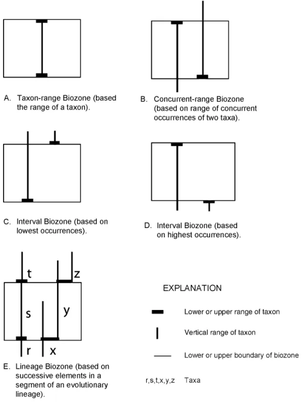
Article 50. Kinds of Biostratigraphic Units ...1574
Remarks: a. Range biozone ...1574
b. Interval biozone ...1574
c. Lineage biozone ...1574
d. Assemblage biozone ...1574
e. Abundance biozone ...1574
f. Hybrid or new types of biozones ...1575
Article 51. Boundaries ...1575
Remark: a. Identification of biozones ...1575
Article 52. [not used] ...1576
Ranks of Biostratigraphic Units ...1576
Article 53. Fundamental Unit ...1576
Remarks: a. Scope ...1576
b. Divisions ...1576
c. Shortened forms of expression ...1576
Biostratigraphic Nomenclature ...1576
Article 54. Establishing Formal units ...1576
Remarks: a. Name ...1576
b. Shorter designations for biozone names ...1576
c. Revision ...1576
d. Defining taxa ...1576
e. Reference sections ...1576
PEDOSTRATIGRAPHIC UNITS ...1576
Nature and Boundaries ...1576
Article 55. Nature of Pedostratigraphic Units ...1576
Remarks: a. Definition ...1577
b. Recognition ...1577
c. Boundaries and stratigraphic position ...1577
d. Traceability ...1577
e. Distinction from pedologic soils ...1577
f. Relation to saprolite and other weathered materials ...1577
g. Distinction from other stratigraphic units ...1577
h. Independence from time concepts ...1578
Pedostratigraphic Nomenclature and Unit ...1578
Article 56. Fundamental Unit ...1578
Article 57. Nomenclature ...1578
Remarks: a. Composite geosols ...1578
b. Characterization ...1578
c. Procedures for establishing formal pedostratigraphic units ...1578
ALLOSTRATIGRAPHIC UNITS ...1578
Nature and Boundaries ...1578
Article 58. Nature of Allostratigraphic Units ...1578
Remarks: a. Purpose ...1578
b. Internal characteristics ...1578
c. Boundaries ...1578
d. Mappability ...1578
e. Type locality and extent ...1578
f. Relation to genesis ...1578
g. Relation to geomorphic surfaces ...1578
h. Relation to soils and paleosols ...1578
i. Relation to inferred geologic history ...1578
j. Relation to time concepts ...1578
k. Extension of allostratigraphic units ...1578
Ranks of Allostratigraphic Units ...1578
Article 59. Hierarchy ...1578
b. Allomember ...1578
c. Allogroup ...1578
d. Changes in rank ...1579
Allostratigraphic Nomenclature ...1579
Article 60. Nomenclature ...1579
Remark: a. Revision ...1579
FORMAL UNITS EXPRESSING OR RELATING TO GEOLOGIC AGE ...1579
KINDS OF GEOLOGIC-TIME UNITS ...1579
Nature and Kinds ...1579
Article 61. Kinds ...1579
Units Based on Material Referents ...1580
Article 62. Kinds Based on Referents ...1580
Article 63. Isochronous Categories ...1580
Remark: a. Extent ...1580
Article 64. Diachronous Categories ...1580
Remarks: a. Diachroneity ...1580
b. Extent ...1581
Units Independent of Material Referents ...1581
Article 65. Numerical Divisions of Time ...1581
CHRONOSTRATIGRAPHIC UNITS ...1581
Nature and Boundaries ...1581
Article 66. Definition ...1581
Remarks: a. Purposes ...1581
b. Nature ...1581
c. Content ...1581
Article 67. Boundaries ...1581
Remark: a. Emphasis on lower boundaries of chronostratigraphic units ...1581
Article 68. Correlation ...1581
Ranks of Chronostratigraphic Units ...1581
Article 69. Hierarchy ...1581
Article 70. Eonothem ...1581
Article 71. Erathem ...1581
Remark: a. Names ...1581
Article 72. System ...1582
Remark: a. Subsystem and supersystem ...1582
Article 73. Series ...1582
Article 74. Stage ...1582
Remark: a. Substage ...1582
Article 75. Chronozone ...1582
Remarks: a. Boundaries of chronozones ...1582
b. Scope ...1582
c. Practical utility ...1582
Chronostratigraphic Nomenclature ...1582
Article 76. Requirements ...1582
Article 77. Nomenclature ...1582
Remarks: a. Systems and units of higher rank ...1582
b. Series and units of lower rank ...1582
Article 78. Stratotypes ...1582
Article 79. Revision of Units ...1583
GEOCHRONOLOGIC UNITS ...1583
Nature and Boundaries ...1583
Article 80. Definition and Basis ...1583
Ranks and Nomenclature of Geochronologic Units ...1583
Article 81. Hierarchy ...1583
POLARITY-CHRONOSTRATIGRAPHIC UNITS ...1583
Nature and Boundaries ...1583
Article 83. Definition ...1583
Remarks: a. Nature ...1583
b. Principal purposes ...1583
c. Recognition ...1583
Article 84. Boundaries ...1583
Ranks and Nomenclature of Polarity-Chronostratigraphic Units ...1583
Article 85. Fundamental Unit ...1583
Remarks: a. Meaning of term ...1583
b. Scope ...1583
c. Ranks ...1583
Article 86. Establishing Formal Units ...1583
Article 87. Name ...1583
Remarks: a. Preservation of established name ...1583
b. Expression of doubt ...1584
POLARITY-CHRONOLOGIC UNITS ...1584
Nature and Boundaries ...1584
Article 88. Definition ...1584
Ranks and Nomenclature of Polarity-Chronologic Units ...1584
Article 89. Fundamental Unit ...1584
Remark: a. Hierarchy ...1584
Article 90. Nomenclature ...1584
DIACHRONIC UNITS ...1584
Nature and Boundaries ...1584
Article 91. Definition ...1584
Remarks: a. Purposes ...1584
b. Scope ...1584
c. Basis ...1584
d. Duration ...1584
Article 92. Boundaries ...1584
Remark: a. Temporal relations ...1584
Ranks and Nomenclature of Diachronic Units ...1584
Article 93. Ranks ...1584
Remarks: a. Diachron ...1584
b. Hierarchical ordering permissible ...1584
c. Episode ...1584
Article 94. Name ...1585
Remarks: a. Formal designation of units ...1585
b. Interregional extension of geographic names ...1585
c. Change from geochronologic to diachronic classification ...1585
Article 95. Establishing Formal Units ...1585
Remark: a. Revision or abandonment ...1585
GEOCHRONOMETRIC UNITS ...1585
Nature and Boundaries ...1585
Article 96. Definition ...1585
Ranks and Nomenclature of Geochronometric Units ...1586
Article 97. Nomenclature ...1586
PART III. ADDENDA REFERENCES ...1586
APPENDICES I. PARTICIPANTS AND CONFEREES IN CODE REVISION ...1587
II. 1977–2002 COMPOSITION OF THE NORTH AMERICAN COMMISSION ON STRATIGRAPHIC NOMENCLATURE.1588 III. REPORTS AND NOTES OF THE AMERICAN COMMISSION ON STRATIGRAPHIC NOMENCLATURE ....1589
ILLUSTRATIONS TABLES 1. Classes of units defined ...1557
FIGURES
1. Relation of geologic time units to the kinds of rock-unit referents on which most are based ...1558
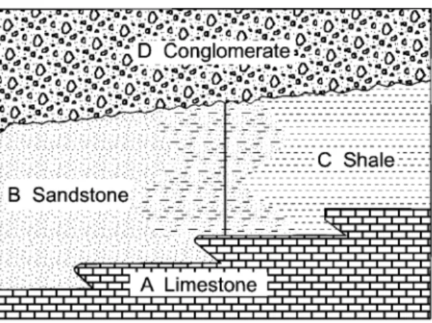
2. Diagrammatic examples of lithostratigraphic boundaries and classification ...1568
3. Lithodemic and lithostratigraphic units ...1571
4. Examples of range, lineage, and interval biozones ...1575
5. Examples of assemblage and abundance biozones ...1576
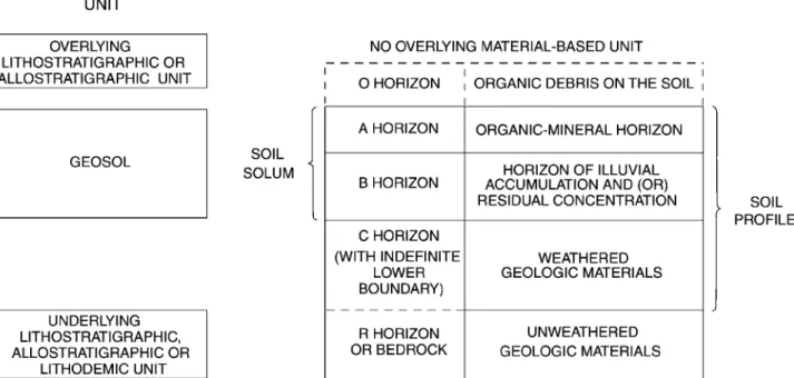
6. Relation between pedostratigraphic units and pedologic profiles ...1577
7. Example of allostratigraphic classification of alluvial and lacustrine deposits in a graben ...1579
8. Example of allostratigraphic classification of contiguous deposits of similar lithology ...1579
9. Example of allostratigraphic classification of lithologically similar, discontinuous terrace deposits ...1580
10. Comparison of geochronologic, chronostratigraphic, and diachronic units ...1584
11. Schematic relation of phases to an episode ...1585
PART I. PREAMBLE
BACKGROUND
PERSPECTIVE
Codes of Stratigraphic Nomenclature prepared by the North American Commission on Stratigraphic Nomencla-ture in 1983, the American Commission on Stratigraphic Nomenclature (ACSN, 1961), and its predecessor (Com-mittee on Stratigraphic Nomenclature, 1933) have been used widely as a basis for stratigraphic terminology. Their formu-lation was a response to needs recognized during the past century by government surveys (both national and local) and by editors of scientific journals for uniform standards and common procedures in defining and classifying formal rock bodies, their fossils, and the time spans represented by them. The 1970 Code (ACSN, 1970) is a slightly revised version of that published in 1961, incorporating some minor amendments adopted by the Commission between 1962 and 1969. The 2005 edition of the 1983 Code incorporates amendments adopted by the Commission between 1983 and 2003. The Codes have served the profession admirably and have been drawn upon heavily for codes and guides pre-pared in other parts of the world (ISSC, 1976, p. 104 – 106; 1994, p. 143 – 147). The principles embodied by any code, however, reflect the state of knowledge at the time of its preparation.
New concepts and techniques developed since 1961 have revolutionized the earth sciences. Moreover, increasingly evi-dent have been the limitations of previous codes in meeting some needs of Precambrian and Quaternary geology and in classification of plutonic, high-grade metamorphic, volcanic, and intensely deformed rock assemblages. In addition, the im-portant contributions of numerous international stratigraphic organizations associated with both the International Union of Geological Sciences (IUGS) and UNESCO, including work-ing groups of the International Geological Correlation Pro-gramme (IGCP), merit recognition and incorporation into a North American code.
For these and other reasons, revision of the 1970 Code was undertaken by committees appointed by the North Ameri-can Commission on Stratigraphic Nomenclature (NACSN). The Commission, founded as the American Commission on Stratigraphic Nomenclature in 1946 (ACSN, 1947), was
renamed the NACSN in 1978 (Weiss, 1979b) to emphasize that delegates from ten organizations in Canada, the United States, and Mexico represent the geological profession through-out North America (Appendix II).
Although many past and current members of the Com-mission helped prepare the 1983 Code, the participation of all interested geologists was sought (for example, Weiss, 1979a). Open forums were held at the national meetings of both the Geological Society of America at San Diego in November, 1979, and the American Association of Petro-leum Geologists at Denver in June, 1980, at which com-ments and suggestions were offered by more than 150 ge-ologists. The resulting draft of this report was printed, through the courtesy of the Canadian Society of Petroleum Geologists, on October 1, 1981, and additional comments were invited from the profession for a period of one year before submittal of this report to the Commission for adop-tion. More than 50 responses were received with sufficient suggestions for improvement to prompt moderate revision of the printed draft (NACSN, 1981). We are particularly in-debted to Hollis D. Hedberg and Amos Salvador for their exhaustive and perceptive reviews of early drafts of this Code, as well as to those who responded to the request for comments. Participants in the preparation and revisions of this report, and conferees, are listed in Appendix I.
Recent amendments to the 1983 Code include allowing electronic publication of new and revised names and correcting inconsistencies to improve clarity (Ferrusquı´a-Villafranca et al., 2001). Also, the Biostratigraphic Units section (Articles 48 to 54) was revised (Lenz et al., 2001).
Some of the expenses incurred in the course of this work were defrayed by National Science Foundation Grant EAR 7919845, for which we express appreciation. Institu-tions represented by the participants have been especially generous in their support.
SCOPE
rigorous study of the composition, geometry, sequence, his-tory, and genesis of rocks and unconsolidated materials. They provide the framework within which time and space relations among rock bodies that constitute the Earth are ordered sys-tematically. Stratigraphic procedures are used not only to reconstruct the history of the Earth and of extra-terrestrial bodies, but also to define the distribution and geometry of some commodities needed by society.Stratigraphic classifica-tionsystematically arranges and partitions bodies of rock or unconsolidated materials of the Earth’s crust into units on the basis of their inherent properties or attributes.
Astratigraphic codeor guide is a formulation of current views on stratigraphic principles and procedures designed to promote standardized classification and formal nomencla-ture of rock materials. It provides the basis for formalization of the language used to denote rock units and their spatial and temporal relations. To be effective, a code must be widely ac-cepted and used; geologic organizations and journals may adopt its recommendations for nomenclatural procedure. Because any code embodies only current concepts and principles, it should have the flexibility to provide for both changes and additions to improve its relevance to new scientific problems. Any system of nomenclature must be sufficiently ex-plicit to enable users to distinguish objects that are embraced in a class from those that are not. This stratigraphic code makes no attempt to systematize structural, petrographic, paleontologic, or physiographic terms. Terms from these other fields that are used as part of formal stratigraphic names should be sufficiently general as to be unaffected by revisions of precise petrographic or other classifications.
The objective of a system of classification is to promote unambiguous communication in a manner not so restrictive as to inhibit scientific progress. To minimize ambiguity, a code must promote recognition of the distinction between observable features (reproducible data) and inferences or interpretations. Moreover, it should be sufficiently adaptable and flexible to promote the further development of science. Stratigraphic classification promotes understanding of thegeometryandsequenceof rock bodies. The development of stratigraphy as a science required formulation of the Law of Superposition to explain sequential stratal relations. Al-though superposition is not applicable to many igneous, meta-morphic, and tectonic rock assemblages, other criteria (such as cross-cutting relations and isotopic dating) can be used to determine sequential arrangements among rock bodies.
The term stratigraphic unitmay be defined in several ways. Etymological emphasis requires that it be a stratum or assemblage of adjacent strata distinguished by any or several of the many properties that rocks may possess (ISSC, 1976, p. 13; 1994, p. 13 – 14). The scope of stratigraphic classi-fication and procedures, however, suggests a broader defi-nition: a naturally occurring body of rock or rock material distinguished from adjoining bodies of rock on the basis of some stated property or properties. Commonly used prop-erties include composition, texture, included fossils, mag-netic signature, radioactivity, seismic velocity, and age. Suf-ficient care is required in defining the boundaries of a unit to enable others to distinguish the material body from those adjoining it. Units based on one property commonly do not coincide with those based on another and, therefore,
dis-tinctive terms are needed to identify the property used in defining each unit.
The adjective stratigraphic is used in two ways in the remainder of this report. In discussions of lithic (used here as synonymous with ‘‘lithologic’’) units, a conscious attempt is made to restrict the term to lithostratigraphic or layered rocks and sequences that obey the Law of Superposition. For nonstratiform rocks (of plutonic or tectonic origin, for ex-ample), the termlithodemic(see Article 27) is used. The ad-jective stratigraphicis also used in a broader sense to refer to those procedures derived from stratigraphy that are now applied to all classes of earth materials.
An assumption made in the material that follows is that the reader has some degree of familiarity with basic prin-ciples of stratigraphy as outlined, for example, by Dunbar and Rodgers (1957), Weller (1960), Shaw (1964), Matthews (1974), Blatt et al. (1990), Boggs (2001), or the Interna-tional Stratigraphic Guide (ISSC, 1976, 1994).
RELATION OF CODES TO INTERNATIONAL GUIDE
Publication of the International Stratigraphic Guide by the International Subcommission on Stratigraphic Classifi-cation (ISSC, 1976), which is being endorsed and adopted throughout the world, played a part in prompting exami-nation of the American Stratigraphic Code and the decision to revise it.
The International Guide embodies principles and pro-cedures that had been adopted by several national and re-gional stratigraphic committees and commissions. More than two decades of effort by H. D. Hedberg and other members of the Subcommission (ISSC, 1976, p. VI, 1, 3) developed the consensus required for preparation of the Guide. Al-though the Guide attempts to cover all kinds of rocks and the diverse ways of investigating them, it is necessarily incomplete. Mechanisms are needed to stimulate individual innovations toward promulgating new concepts, principles, and practices that subsequently may be found worthy of inclusion in later editions of the Guide. The flexibility of national and regional committees or commissions enables them to perform this function more readily than an inter-national subcommission, even while they adopt the Guide as the international standard of stratigraphic classification.
A guiding principle in preparing this Code has been to make it as consistent as possible with the International Guide, and at the same time to foster further innovations to meet the expanding and changing needs of earth scientists on the North American continent.
OVERVIEW
CATEGORIES RECOGNIZED
formal categories are recognized here relative to previous codes or in the International Guide (ISSC, 1994). On the other hand, no special provision is made for formalizing cer-tain kinds of units (deep oceanic, for example) that may be accommodated by available categories.
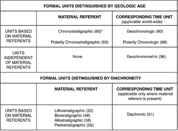
Four principal categories of units have previously been used widely in traditional stratigraphic work; these have been termed lithostratigraphic, biostratigraphic, chronostratigraph-ic, and geochronologic and are distinguished as follows:
1. Alithostratigraphic unitis a stratum or body of strata, generally but not invariably layered, generally but not in-variably tabular, that conforms to the Law of Superposi-tion and is distinguished and delimited on the basis of lithic characteristics and stratigraphic position. Example: Navajo Sandstone.
2. Abiostratigraphic unitis a body of rock defined and characterized by its fossil content. Example:Discoaster multi-radiatusInterval Biozone.
3. A chronostratigraphic unit is a body of rock estab-lished to serve as the material reference for all rocks formed during the same span of time. Example: Devonian System. Each boundary of a chronostratigraphic unit is synchronous. Chronostratigraphy provides a means of organizing strata into units based on their age relations. A chronostratigraphic body also serves as the basis for defining the specific interval of geologic time, or geochronologic unit, represented by the referent.
4. Ageochronologic unitis a division of time distinguished on the basis of the rock record preserved in a chronostrati-graphic unit. Example: Devonian Period.
The first two categories are comparable in that they consist of material units defined on the basis of content. The third category differs from the first two in that it serves primarily as the standard for recognizing and isolating terials of a specific age. The fourth, in contrast, is not a ma-terial, but rather a conceptual, unit; it is a division of time. Although a geochronologic unit is not a stratigraphic body, it is so intimately tied to chronostratigraphy that the two are discussed properly together.
Properties and procedures that may be used in distin-guishing geologic units are both diverse and numerous (ISSC, 1976, p. 1, 96; 1994, p. 102 – 103; Harland, 1977, p. 230), but all may be assigned to the following principal classes of cate-gories used in stratigraphic classification (Table 1), which are discussed below:
I. Material categories based on content, inherent at-tributes, or physical limits
II. Categories expressing or related to geologic age A. Material categories used to define temporal spans B. Temporal (non-material) categories
Material Categories Based on Content or Physical Limits
The basic building blocks for most geologic work are rock bodies, defined on the basis of composition and related lithic characteristics, or on their physical, chemical, or biologic content or properties. Emphasis is placed on the relative ob-jectivity and reproducibility of data used in defining units within each category.
Foremost properties of rocks are composition, texture, fabric, structure, and color, which together are designated lithic characteristics. These serve as the basis for distinguish-ing and defindistinguish-ing the most fundamental of all formal units. Such units based primarily on composition are divided into two categories (Henderson et al., 1980): lithostratigraphic (Article 22) and lithodemic (defined here in Article 31). A lithostratigraphic unit obeys the Law of Superposition, whereas a lithodemic unit does not. Alithodemic unitis a defined body of predominantly intrusive, highly metamorphosed, or in-tensely deformed rock that, because it is intrusive or has lost primary structure through metamorphism or tectonism, generally does not conform to the Law of Superposition.
Recognition during the past several decades that rema-nent magnetism in rocks records the Earth’s past magnetic characteristics (Cox, et al., 1963) provides a powerful new tool encompassed by magnetostratigraphy (McDougall, 1977; McElhinny, 1978). Magnetostratigraphy (Article 43) is the study of remanent magnetism in rocks; it is the record of the Earth’s magnetic polarity (or field reversals), dipole-field-pole position (including apparent polar wander), the non-dipole component (secular variation), and field intensi-ty. Polarity is of particular utility and is used to define a magnetopolarity unit(Article 44) as a body of rock identi-fied by its remanent magnetic polarity (ACSN, 1976; ISSC, 1979). Empirical demonstration of uniform polarity does not necessarily have direct temporal connotations because the remanent magnetism need not be related to rock depo-sition or crystallization. Nevertheless, polarity is a physical attribute that may characterize a body of rock.
Biologic remains contained in, or forming, strata are uniquely important in stratigraphic practice. First, they pro-vide the means of defining and recognizing material units
Table 1.Classes of Units Defined*
I. MATERIAL CATEGORIES BASED ON CONTENT OR PHYSICAL LIMITS
Lithostratigraphic (22)*
Lithodemic(31)**
Magnetopolarity(44) Biostratigraphic (48) Pedostratigraphic (55)
Allostratigraphic(58)
II. CATEGORIES EXPRESSING OR RELATED TO GEOLOGIC AGE A. Material Categories Used to Define Temporal Spans
Chronostratigraphic (66)
Polarity-Chronostratigraphic(83) B. Temporal (Non-Material) Categories
Geochronologic (80)
Polarity-Chronologic(88)
Diachronic(91)
Geochronometric(96)
*Numbers in parentheses are the numbers of the Articles where units are defined.
based on fossil content (biostratigraphic units, Article 48). Second, the irreversibility of organic evolution makes it pos-sible to partition enclosing strata temporally. Third, biologic remains provide important data for the reconstruction of ancient environments of deposition.
Composition also is important in distinguishing pedo-stratigraphic units. A pedostratigraphic unit is a body of rock that consists of one or more pedologic horizons devel-oped in one or more lithic units now buried by a formally defined lithostratigraphic or allostratigraphic unit or units. A pedostratigraphic unit is the part of a buried soil charac-terized by one or more clearly defined soil horizons contain-ing pedogenically formed minerals and organic compounds. Pedostratigraphic terminology is discussed below and in Article 55.
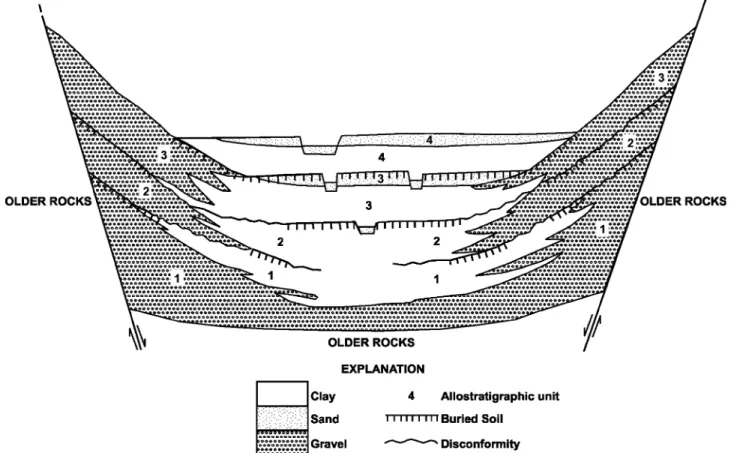
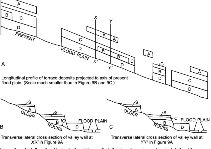
Many upper Cenozoic, especially Quaternary, deposits are distinguished and delineated on the basis of content, for which lithostratigraphic classification is appropriate. How-ever, others are delineated on the basis of criteria other than content. To facilitate the reconstruction of geologic history, some compositionally similar deposits in vertical sequence merit distinction as separate stratigraphic units because they are the products of different processes; others merit dis-tinction because they are of demonstrably different ages. Lithostratigraphic classification of these units is impractical and a new approach, allostratigraphic classification, is intro-duced here and may prove applicable to older deposits as well. Anallostratigraphic unit is a mappable body of rock defined and identified on the basis of bounding disconti-nuities (Article 58 and related Remarks).
Geologic-Climate units, defined in the 1970 Code (ACSN, 1970, p. 31), were abandoned in the 1983 Code because they proved to be of dubious utility. Inferences regarding climate are subjective and too tenuous a basis for the definition of formal geologic units. Such inferences commonly are based on deposits assigned more appropriately to lithostratigraphic or allostratigraphic units and may be expressed in terms of diachronic units (defined below).
Categories Expressing or Related to Geologic Age
Time is a single, irreversible continuum. Nevertheless, various categories of units are used to define intervals of geo-logic time, just as terms having different bases, such as Paleo-lithic, Renaissance, and Elizabethan, are used to designate specific periods of human history. Different temporal cate-gories are established to express intervals of time distin-guished in different ways.
Major objectives of stratigraphic classification are to provide a basis for systematic ordering of the time and space relations of rock bodies and to establish a time framework for the discussion of geologic history. For such purposes, units of geologic time traditionally have been named to rep-resent the span of time during which a well-described se-quence of rock, or a chronostratigraphic unit, was deposited (‘‘time units based on material referents,’’ Figure 1). This procedure continues, to the exclusion of other possible ap-proaches, to be standard practice in studies of Phanerozoic rocks. Despite admonitions in previous American codes and
the International Stratigraphic Guide (ISSC, 1976, p. 81; 1994, p. 87) that similar procedures should be applied to the Precambrian, no comparable chronostratigraphic units, or geochronologic units derived therefrom, proposed for the Precambrian have yet been accepted worldwide. Instead, the IUGS Subcommission on Precambrian Stratigraphy (Sims, 1979) and its Working Groups (Harrison and Peterman, 1980) recommend division of Precambrian time into geo-chronometric unitshaving no material referents.
A distinction is made throughout this report between isochronous and synchronous, as urged by Cumming et al. (1959, p. 730), although the terms have been used synony-mously by many.Isochronousmeans of equal duration; syn-chronousmeans simultaneous, or occurring at the same time. Although two rock bodies of very different ages may be formed during equal durations of time, the term isochronous is not applied to them in the earth sciences. Rather, iso-chronous bodies are those bounded by syniso-chronous sur-faces and formed during the same span of time. Isochron, in contrast, is used for a line connecting points of equal age on a graph representing physical or chemical phenomena; the line represents the same or equal time. The adjective diachronousis applied either to a rock unit with one or two bounding surfaces that are not synchronous, or to a boundary that is not synchronous (that ‘‘transgresses time’’).
Two classes of time units based on material referents, or stratotypes, are recognized (Figure 1). The first is that of the traditional and conceptually isochronous units, and includes geochronologic units, which are based onchronostratigraphic units, andpolarity-chronologic units. These isochronous units have worldwide applicability and may be used even in areas lacking a material record of the named span of time. The second class of time units, newly defined in this Code, con-sists ofdiachronic units (Article 91) that are based on rock bodies known to be diachronous. In contrast to isochronous units, a diachronic term is used only where a material refer-ent is presrefer-ent; a diachronic unit is coextensive with the ma-terial body or bodies on which it is based.
A chronostratigraphic unit, as defined above and in Article 66, is a body of rock established to serve as the ma-terial reference for all rocks formed during the same span of time; its boundaries are synchronous. It is the referent for a geochronologic unit, as defined above and in Article 80. Inter-nationally accepted and traditional chronostratigraphic units were based initially on the time spans of lithostratigraphic units, biostratigraphic units, or other features of the rock record that have specific durations. In sum, they form the Standard Global Chronostratigraphic Scale (ISSC, 1976, p. 76– 81; 1994, p. 85; Harland, 1978), consisting of established sys-tems and series.
Apolarity-chronostratigraphic unitis a body of rock that contains a primary magnetopolarity record imposed when the rock was deposited or crystallized (Article 83). It serves as a material standard or referent for a part of geologic time during which the Earth’s magnetic field had a characteristic polarity or sequence of polarities; that is, for a polarity-chronologic unit(Article 88).
Adiachronic unitcomprises the unequal spans of time represented by one or more specific diachronous rock bodies (Article 91). Such bodies may be lithostratigraphic,
biostrati-graphic, pedostratibiostrati-graphic, allostratibiostrati-graphic, or an assemblage of such units. A diachronic unit is applicable only where its material referent is present.
Ageochronometric(or chronometric)unitis an isochro-nous direct division of geologic time expressed in years (Article 96). It has no material referent.
Pedostratigraphic Terms
The definition and nomenclature for pedostratigraphic units2in this Code differ from those for soil-stratigraphic units in the 1970 Code (ACSN, 1970, Article 18), by being more specific with regard to content, boundaries, and the basis for determining stratigraphic position.
The term ‘‘soil’’ has different meanings to the geologist, the soil scientist, the engineer, and the layman, and com-monly has no stratigraphic significance. The termpaleosolis currently used in North America for any soil that formed on a landscape of the past; it may be a buried soil, a relict soil, or an exhumed soil (Ruhe, 1965; Valentine and Dalrymple, 1976).
Apedologic soilis composed of one or more soil horizons3. A soil horizon is a layer within a pedologic soil that (1) is approximately parallel to the soil surface, (2) has distinc-tive physical, chemical, biological, and morphological prop-erties that differ from those of adjacent, genetically related, soil horizons, and (3) is distinguished from other soil hori-zons by objective compositional properties that can be ob-served or measured in the field. The physical boundaries of buried pedologic horizons are objective traceable boundaries with stratigraphic significance. A buried pedologic soil pro-vides the material basis for definition of a stratigraphic unit in pedostratigraphic classification (Article 55), but a buried pedologic soil may be somewhat more inclusive than a pedostratigraphic unit. A pedologic soil may contain both an O horizon and the entire C horizon (Figure 6), whereas the former is excluded and the latter need not be included in a pedostratigraphic unit.
The definition and nomenclature for pedostratigraphic units in this Code differ from those of soil stratigraphic units proposed by the International Union for Quaternary Re-search and International Society of Soil Science (Parsons, 1981). The pedostratigraphic unit, geosol, also differs from the proposed INQUA-ISSS soil-stratigraphic unit, pedo-derm, in several ways, the most important of which are the following: (1) a geosol may be in any part of the geologic column, whereas a pedoderm is a surficial soil; (2) a geosol is a buried soil, whereas a pedoderm may be a buried, relict, or exhumed soil; (3) the boundaries and stratigraphic position of a geosol are defined and delineated by criteria that differ from those for a pedoderm; and (4) a geosol may be either all or only a part of a buried soil, whereas a pedoderm is the entire soil.
2From Greek,pedon, ground or soil.
3As used in a geological sense, ahorizonis a surface or line. In
The termgeosol, as defined by Morrison (1967, p. 3), is a laterally traceable, mappable, geologic weathering profile that has a consistent stratigraphic position. The term is adopted and redefined here as the fundamental and only unit in formal pedostratigraphic classification (Article 56).
FORMAL AND INFORMAL UNITS
Although the Code emphasizes formal categories of geologic units, informal nomenclature is highly useful in stratigraphic work.
Formally named units are those that are named in ac-cordance with an established scheme of classification; the fact of formality is conveyed by capitalization of the initial letter of therankorunitterm (for example, Morrison Formation). Informal units, whose unit terms are ordinary nouns, are not protected by the stability provided by proper formalization and recommended classification procedures. Informal terms are devised for both economic and scientific reasons. For-malization is appropriate for those units requiring stability of nomenclature, particularly those likely to be extended far beyond the locality in which they were first recognized. In-formal terms are appropriate for casually mentioned and innovative units. Also, most economic units, those defined by unconventional criteria, and those that may be too thin to map at usual scales may be informal.
Casually mentioned geologic units not defined in ac-cordance with this Code are informal. For many of these, there may be insufficient need or information, or perhaps an inappropriate basis, for formal designations. Informal des-ignations as beds or lithozones (the pebbly beds, the shaly zone, third coal) are appropriate for many such units.
Most economic units, such as aquifers, oil sands, coal beds, quarry layers, and ore-bearing ‘‘reefs,’’ are informal, even though they may be named. Some such units, however, are so significant scientifically and economically that they merit formal recognition as beds, members, or formations.
Innovative approaches in regional stratigraphic studies have resulted in the recognition and definition of units best left as informal, at least for the time being. Units bounded by major regional unconformities on the North American craton were designated ‘‘sequences’’ (example: Sauk sequence) by Sloss (1963). Major unconformity-bounded units also were designated ‘‘synthems’’ by Chang (1975), who recom-mended that they be treated formally. Marker-defined units that are continuous from one lithofacies to another were designated ‘‘formats’’ by Forgotson (1957). The term ‘‘chro-nosome’’ was proposed by Schultz (1982) for rocks of diverse facies corresponding to geographic variations in sedimen-tation during an interval of deposition identified on the basis of bounding stratigraphic markers. Successions of faunal zones containing evolutionally related forms, but bounded by non-evolutionary biotic discontinuities, were termed ‘‘biomeres’’ (Palmer, 1965). The foregoing are only a few selected examples to demonstrate how informality provides a continuing avenue for innovation.
The termsmagnafaciesandparvafacies, coined by Caster (1934) to emphasize the distinction between lithostratigraphic
and chronostratigraphic units in sequences displaying marked facies variation, have remained informal despite their impact on clarifying the concepts involved.
Tephrochronologic studies provide examples of infor-mal units that are too thin to map at conventional scales but yet invaluable for dating important geologic events. Although some such units are named for physiographic features and places where first recognized (e.g., Guaje pumice bed, where it is not mapped as the Guaje Member of the Bandelier Tuff), others bear the same name as the volcanic vent (e.g., Huckleberry Ridge ash bed of Izett and Wilcox, 1981).
Informal geologic units are designated by ordinary nouns, adjectives, or geographic terms and lithic or unit terms that are not capitalized (chalky formation or beds, St. Francis coal).
No geologic unit should be established and defined, whether formally or informally, unless its recognition serves a clear purpose.
CORRELATION
Correlationis a procedure for demonstrating correspon-dence between geographically separated parts of a geologic unit. The term is a general one having diverse meanings in different disciplines. Demonstration of temporal corre-spondence is one of the most important objectives of stratig-raphy. The termcorrelationfrequently is misused to express the idea that a unit has been identified or recognized.
Correlationis used in this Code as the demonstration of correspondence between two geologic units in both some defined property and relative stratigraphic position. Because correspondence may be based on various properties, three kinds of correlation are best distinguished by more specific terms. Lithocorrelation links units of similar lithology and stratigraphic position (or sequential or geometric relation for lithodemic units).Biocorrelationexpresses similarity of fos-sil content and biostratigraphic position.Chronocorrelation expresses correspondence in age and in chronostratigraphic position.
Other terms that have been used for the similarity of content and stratal succession are homotaxy and chronotaxy. Homotaxy is the similarity in separate regions of the serial arrangement or succession of strata of comparable composi-tions or of included fossils. The term is derived from homo-taxis, proposed by Huxley (1862, p. xlvi) to emphasize that similarity in succession does not prove age equivalence of comparable units. The termchronotaxyhas been applied to similar stratigraphic sequences composed of units that are of equivalent age (Henbest, 1952, p. 310).
PART II. ARTICLES
INTRODUCTION
Article 1. —Purpose. This Code describes explicit strati-graphic procedures for classifying and naming geologic units accorded formal status. Such procedures, if widely adopted, assure consistent and uniform usage in classification and termi-nology and, therefore, promote unambiguous communication.
Article 2.—Categories. Categories of formal stratigraphic units, though diverse, are of three classes. The first class (I on Table 1) is of rock-material categories based on content, in-herent attributes, or physical limits, and includes litho-stratigraphic, lithodemic, magnetopolarity, biolitho-stratigraphic, pedostratigraphic, and allostratigraphic units. The second class (IIA on Table 1) is of material categories used as standards for defining spans of geologic time, and includes chronostrati-graphic and polarity-chronostratichronostrati-graphic units. The third class (IIB on Table 1) is of non-material temporal categories, and includes geochronologic, polarity-chronologic, diachronic, and geochronometric units.
GENERAL PROCEDURES
DEFINITION OF FORMAL UNITS
Article 3. —Requirements for Formally Named Geologic Units. Naming, establishing, revising, redefining, and aban-doning formal geologic units require publication in a recog-nized scientific medium of a comprehensive statement, which includes (i) intent to designate or modify a formal unit; (ii) designation of category and rank of unit; (iii) selection and derivation of name; (iv) specification of stratotype (where applicable); (v) description of unit; (vi) definition of bound-aries; (vii) historical background; (viii) dimensions, shape, and other regional aspects; (ix) geologic age; (x) correlations; and possibly (xi) genesis (where applicable). These requirements apply to subsurface and offshore, as well as exposed, units.
Article 4. —Publication.4‘‘Publication in a recognized scientific medium’’ in conformance with this Code means that a work, when first issued, must (1) be reproduced in ink on paper; be reproduced electronically on CD-ROM, on the Internet, or by another electronic method widely accepted by the scientific community; or be reproduced by some method that assures numerous identical copies and wide distribution; (2) be issued for the purpose of scientific, public, permanent record; (3) be readily obtainable by purchase or free distri-bution; and (4) have undergone adequate peer review.
Remarks. (a)Inadequate publication. — The following do not constitute publication within the meaning of the Code: (1)
dis-tribution of microfilms, microcards, or matter reproduced by similar methods; (2) distribution to colleagues or students of a note, even if printed, in explanation of an accompanying illustration; (3) dis-tribution of proof sheets; (4) open-file release; (5) theses, disserta-tions, and dissertation abstracts; (6) mention at a scientific or other meeting; (7) mention in an abstract, map explanation, or figure cap-tion; (8) labeling of a rock specimen in a colleccap-tion; (9) mere deposit of a document in a library; (10) anonymous publication; (11) men-tion in the popular press or in a legal document; (12) distribumen-tion by an author by posting on the Internet, or by another electronic me-dium, a document that has not undergone the procedures stated below (Remark c).
( b) Guidebooks. — A guidebook with distribution limited to participants of a field excursion does not meet the test of availability. Some organizations publish and distribute widely large editions of serial guidebooks that include refereed regional papers; although these do meet the tests of scientific purpose and availability, and therefore constitute valid publication, other media are preferable.
(c)Electronic publication. — Publication in electronic medium, which has become widespread since distribution of the Code in 1983, is confined to publication in a journal or other publication series by a widely recognized (1) scientific society, (2) government agency, (3) academic institution, or (4) other respected scientific publisher. All versions distributed must be the same, whether in paper or electronic form, without alteration. Other requirements are as follows: (1) archival practices adequate for future availability; (2) suitable typography; (3) coding and markup practices that ad-here to accepted standards; (4) database preparation that includes satisfactory search and retrieval tools, as well as the capability for downloading to a researcher’s local printer; and (5) adequate copy-editing standards. New stratigraphic names can be published electronically.
Article 5. —Intent and Utility. To be valid, a new unit must serve a clear purpose and be duly proposed and duly described, and the intent to establish it must be specified. Casual mention of a unit, such as ‘‘the granite exposed near the Middleville schoolhouse,’’ does not establish a new for-mal unit, nor does mere use in a table, columnar section, or map.
Remark. (a) Demonstration of purpose served. — The initial definition or revision of a named geologic unit constitutes, in es-sence, a proposal. As such, it lacks status until use by others demon-strates that a clear purpose has been served. A unit becomes es-tablished through repeated demonstration of its utility. The decision not to use a newly proposed or a newly revised term requires a full discussion of its unsuitability.
Article 6. —Category and Rank. The category and rank of a new or revised unit must be specified.
Remark. (a)Need for specification. — Many stratigraphic con-troversies have arisen from confusion or misinterpretation of the category of a unit (for example, lithostratigraphic vs. chronostrati-graphic). Specification and unambiguous description of the category is of paramount importance. Selection and designation of an appropriate rank from the distinctive terminology developed for each category help serve this function ( Table 2).
Article 7. —Name. The name of a formal geologic unit is compound. For most categories, the name of a unit should consist of a geographic name combined with an appropri-ate rank ( Wasatch Formation) or descriptive term ( Viola 4
Limestone). Biostratigraphic units are designated by appro-priate biologic forms (Exus albus Assemblage Biozone). Worldwide chronostratigraphic units bear long established and generally accepted names of diverse origins ( Triassic System). The first letters of all words used in the names of formal geologic units are capitalized (except for the trivial species and subspecies terms in the name of a biostratigraphic unit).
Remarks. (a) Appropriate geographic terms. — Geographic names derived from permanent natural or artificial features at or near which the unit is present are preferable to those derived from impermanent features such as farms, schools, stores, churches, crossroads, and small communities. Appropriate names may be se-lected from those shown on topographic, state, provincial, county, forest service, hydrographic, or comparable maps, particularly those showing names approved by a national board for geographic names. The generic part of a geographic name, e.g., river, lake, village, should be omitted from new terms, unless required to distinguish between two otherwise identical names (e.g., Redstone Formation and Redstone River Formation). Two names should not be derived from the same geographic feature. A unit should not be named for the source of its components; for example, a deposit inferred to have been derived from the Keewatin glaciation center should not be designated the ‘‘Keewatin Till.’’
( b) Duplication of names. — Responsibility for avoiding du-plication, either in use of the same name for different units (hom-onymy) or in use of different names for the same unit (synonomy),
rests with the proposer. Although the same geographic term has been applied to different categories of units (example: the lithostrati-graphic Word Formation and the chronostratilithostrati-graphic Wordian Stage) now entrenched in the literature, the practice is undesirable. The extensive geologic nomenclature of North America, including not only names but also nomenclatural history of formal units, is re-corded in compendia maintained by the Committee on Stratigraphic Nomenclature of the Geological Survey of Canada, Ottawa, Ontario; by the Geologic Names Committee of the United States Geological Survey, Reston, Virginia; by the Instituto de Geologia, Ciudad Uni-versitaria, Me´xico, D.F.; and by many state and provincial geological surveys. These organizations respond to inquiries regarding the avail-ability of names, and some are prepared to reserve names for units that are likely to be defined in the next year or two.
(c)Priority and preservation of established names. — Stability of nomenclature is maintained by use of the rule of priority and by preservation of well-established names. Names should not be modified without explaining the need. Priority in publication is to be respected, but priority alone does not justify displacing a well-established name by one neither well-known nor commonly used; nor should an inadequately established name be preserved merely on the basis of priority. Redefinitions in precise terms are preferable to abandonment of the names of well-established units that may have been defined imprecisely but nonetheless in conformance with older and less stringent standards.
(d)Differences of spelling and changes in name. — The geo-graphic component of a well-established stratigeo-graphic name is not changed due to differences in spelling or changes in the name of a geographic feature. The name Bennett Shale, for example, used for
more than half a century, need not be altered because the town is named Bennet. Nor should the Mauch Chunk Formation be changed because the town has been renamed Jim Thorpe. Disappearance of an impermanent geographic feature, such as a town, does not affect the name of an established geologic unit.
(e)Names in different countries and different languages. — For geologic units that cross local and international boundaries, a single name for each is preferable to several. Spelling of a geographic name commonly conforms to the usage of the country and linguistic group involved. Although geographic names are not translated (Cu-chillo is not translated to Knife), lithologic or rank terms are (Ed-wards Limestone, Caliza Ed(Ed-wards; Formacio´n La Casita, La Casita Formation).
Article 8. —Stratotypes. The designation of a unit or boundary stratotype (type section or type locality) is essential in the definition of most formal geologic units. Many kinds of units are best defined by reference to an accessible and specific sequence of rock that may be examined and studied by others. A stratotype is the standard (original or subse-quently designated) for a named geologic unit or boundary and constitutes the basis for definition or recognition of that unit or boundary; therefore, it must be illustrative and representative of the concept of the unit or boundary being defined.
Remarks. (a)Unit stratotype. — A unit stratotype is the type section for a stratiform deposit or the type area for a nonstratiform body that serves as the standard for definition and recognition of a geologic unit. The upper and lower limits of a unit stratotype are designated points in a specific sequence or locality and serve as the standards for definition and recognition of a stratigraphic unit’s boundaries.
( b)Boundary stratotype. — A boundary stratotype is the type locality for the boundary reference point for a stratigraphic unit. Both boundary stratotypes for any unit need not be in the same section or region. Each boundary stratotype serves as the standard for definition and recognition of the base of a stratigraphic unit. The top of a unit may be defined by the boundary stratotype of the next higher stratigraphic unit.
(c)Type locality. — A type locality is the specified geographic locality where the stratotype of a formal unit or unit boundary was originally defined and named. A type area is the geographic territory encompassing the type locality. Before the concept of a stratotype was developed, only type localities and areas were designated for many geologic units that are now long- and well-established. Strato-types, though now mandatory in defining most stratiform units, are impractical in definitions of many large nonstratiform rock bodies whose diverse major components may be best displayed at several reference localities.
(d) Composite-stratotype. — A composite-stratotype consists of several reference sections (which may include a type section) required to demonstrate the range or totality of a stratigraphic unit.
(e) Reference sections. — Reference sections may serve as invaluable standards in definitions or revisions of formal geologic units. For those well-established stratigraphic units for which a type section never was specified, a principal reference section (lecto-stratotype of ISSC, 1976, p. 26; 1994, p. 28) may be designated. A principal reference section (neostratotype of ISSC, 1976, p. 26; 1994, p. 28) also may be designated for those units or boundaries whose stratotypes have been destroyed, covered, or otherwise made inaccessible. Supplementary reference sections often are designated to illustrate the diversity or heterogeneity of a defined unit or some
critical feature not evident or exposed in the stratotype. Once a unit or boundary stratotype section is designated, it is never abandoned or changed; however, if a stratotype proves inadequate, it may be supplemented by a principal reference section or by several reference sections that may constitute a composite-stratotype.
(f )Stratotype descriptions. — Stratotypes should be described both geographically and geologically. Sufficient geographic detail must be included to enable others to find the stratotype in the field, and may consist of maps and/ or aerial photographs showing loca-tion and access, as well as appropriate coordinates or bearings. Geo-logic information should include thickness, descriptive criteria ap-propriate to the recognition of the unit and its boundaries, and discussion of the relation of the unit to other geologic units of the area. A carefully measured and described section provides the best foundation for definition of stratiform units. Graphic profiles, columnar sections, structure-sections, and photographs are useful supplements to a description; a geologic map of the area including the type locality is essential.
Article 9. —Unit Description. A unit proposed for formal status should be described and defined so clearly that any subsequent investigator can recognize that unit un-equivocally. Distinguishing features that characterize a unit may include any or several of the following: composition, texture, primary structures, structural attitudes, biologic re-mains, readily apparent mineral composition (e.g., calcite vs. dolomite), geochemistry, geophysical properties (including magnetic signatures), geomorphic expression, unconformable or cross-cutting relations, and age. Although all distinguishing features pertinent to the unit category should be described sufficiently to characterize the unit, those not pertinent to the category (such as age and inferred genesis for lithostrati-graphic units, or lithology for biostratilithostrati-graphic units) should not be made part of the definition.
Article 10. —Boundaries. The criteria specified for the recognition of boundaries between adjoining geologic units are of paramount importance because they provide the basis for scientific reproducibility of results. Care is required in de-scribing the criteria, which must be appropriate to the cate-gory of unit involved.
Remarks. (a) Boundaries between intergradational units. — Contacts between rocks of markedly contrasting composition are appropriate boundaries of lithic units, but some rocks grade into, or intertongue with, others of different lithology. Consequently, some boundaries are necessarily arbitrary as, for example, the top of the uppermost limestone in a sequence of interbedded limestone and shale. Such arbitrary boundaries commonly are diachronous.