Geophysical and petrological characterization of the lithospheric mantle in Iberia and North Africa
192
0
0
Texto completo
(2) Consejo Superior de Investigaciones Científicas (CSIC) Instituto de Ciencias de la Tierra “Jaume Almera”-ICTJA-CSIC Departamento de Estructura, Dinámica de la Tierra y Cristalografía. Universidad de Barcelona Departamento de Geodinámica y Geofísica Programa de doctorado Ciencias de la Tierra. Geophysical and petrological characterization of the lithospheric mantle in Iberia and North Africa Memoria realizada por Alberto Carballo para optar al grado de Doctor bajo la dirección de los doctores Manel Fernàndez e Ivone Jiménez Munt. Alberto Carballo González Barcelona, 30 de Abril de 2015. Directores:. Dr. Manel Fernàndez Ortiga. Tutor:. Dra. Ivone Jiménez-Munt. Dr. Juan José Ledo Fernández.
(3)
(4) Si no intentamos superar nuestros límites jamás sabremos donde están. -Ayrton Senna-.
(5)
(6) Agradecimientos Por fin ha llegado este anhelado momento, un momento el cual durante estos cuatro años y medio no me atrevía ni a imaginar. Heme aquí en la dulce tesitura de trasladar los últimos agradecimientos a todo aquel que durante esta aventura que ya acaba me ha aportado algo y ha ayudado con su presencia. Sin más dilación, desde la silla que me ha acompañado todo este tiempo (en ocasiones postrado y esclavo), quiero en primer lugar agradecerles a mis directores de Tesis, Manel e Ivone, la oportunidad de poder hacer un Doctorado y su dedicación durante todo este proceso. A Manel, el enseñarme no sólo a ser más exigente conmigo mismo sino con todo, su visión global de la geofísica compartiendo conmigo sus amplios saberes y sus discusiones sobre política para poder entender la idiosincrasia del país. A Ivone, su disponibilidad a la hora de ayudarme, sus enseñanzas en la parte más técnica de programación y su visión más pragmática de todo. Sin vuestra ayuda no hubiese sido posible. En especial quiero dar las gracias a Montse por todo lo que me ha ayudado, enseñado y apoyado. Sin ella tampoco hubiera sido posible. No quiero olvidarme de toda la gente del departamento de Estructura y Dinámica de la Tierra como Jaume, Antonio, Dani y Jordi de los que he tenido la oportunidad de aprender, gracias. También al Consejo en el que he estado trabajando estos años. A Juanjo Ledo que aceptó la tutoría de un servidor, a la comisión de doctorado y Carles Martín Closas por seguirme durante estos años. A Javier Fullea por acoger a este humilde becario (precario) en Dublín durante casi dos fantásticos meses y por ayudarme a hacer mis primeros pinitos en FORTRAN. A Puy le debo el iniciarme en el mundillo de la geofísica y el empujón para llegar aquí. A David Pedreira que amablemente siempre me echó una mano y también Juan Carlos Afonso del que me he visto beneficiado utilizando su programa. En un alarde de corporativismo (guiño) quiero agradecer especialmente a toda la muchachada del Almera hacer más fácil mi estancia aquí: Xevi, Dario, Silvia, Laura, Steffi, Helena, Chusa, Guiomar, Jose, Marc, Mar, Alba, Giovanni, Mireia, Raquel, Bea, Clara y demás doctorandos que han pasado por el Almera. También a los que ya nos son doctorandos (por no decir muchachada) como Ignacio, Eduard, Sofía, David, Max, Mario, Vinyet… y a los compañeros de Máster. Huelga decir que es necesario destacar a mis dos compañeros de despacho que han convivido conmigo en esta ardua andadura. A Lavinia, que ha llevado un camino paralelo al mío y ha padecido conmigo las sinrazones de LitMod, grazie mille (manos en posición italiana). A Globig, ese joven teutón venido de la extinta Alemania Oriental al que para describir sus andanzas harían falta dos Tesis como esta, Danke mein Kommunistisch Kamerad..
(7) A mis amigos salmantinos de toda la vida, la vieja guardia, compañeros de fátigas y miles de batallas (y las que quedan), a Manu, Julio, Guille, Zato, Olea, Astu, Nice y Juan, muchas gracias. A toda la gente de Barcelona que he conocido y tan buenos momentos me han dado: Anye, María, Davids, Nuria, Almen, Jeny, Dani… Y a todo el Munseñ, en nuestra memoria siempre estará la Décima (Liga). Mención aparte para Davids y Juan que me dieron cobijo y un gran recibimiento a mi llegada a la Ciudad Condal. Aquí quiero acentuar la capacidad de vuestro afilado y sibilino sarcasmo a la hora de banalizar todos los problemas, sin él no lo hubiese conseguido. Mención especial también merece Marta, quién me soporta estoicamente en todos los momentos y que me ha dado paz en una vida de guerra. Finalmente, quiero agradecérselo especialmente a la famila que es la que más sufre conmigo. A Cris por su apoyo incondicional e inquebratntable, y por estar siempre ahí. A mi padre por su Fé en mi y por todas las horas que ha echado conmigo tanto en el fútbol o enseñándome siempre algo. Y sobretodo, a mi madre porque es mi madre y por haberme inculcado la cultura del esfuerzo. Muchas gracias a todos por haber formado parte de mis venturas y desventuras durante estos años y en las que he sufrido altibajos, algún tras piés e incluso hartazgo, pero creánme cuando les digo que ahora empieza a compensar.. Alberto Carballo González Barcelona, 2015..
(8) Funding The author of this thesis benefits from a four-year JAE Pre-CP (2010-00036) fellowship from CSIC between 2010 and 2014. This thesis has been supported by the Topo-Iberia Consolider-Ingenio project and GASAM/TopoMed with reference CSD2006-0004 and CGL2008-03474-E/BTE/07-TOPO-EUROPE-FP-006, respectively..
(9)
(10) CONTENTS Prologue. IV. Summary. V. Thesis. 1. Chapter 1: General introduction. 1. 1.1. – Motivation and overview 1.2. – Methodology 1.3. – Geological setting 1.3.1. – Variscan domain 1.3.2. – Alpine domain 1.3.3. – The Central System and adjacent foreland basins 1.3.4. – The Betic–Rif orogen and west Mediterranean basins 1.3.5. – The Atlas Mountains and the Sahara platform 1.3.6. – Neogene and Quaternary volcanism 1.4. – Geophysical data 1.4.1. – Global geophysical data. 3 9 13 13 14 15 16 18 19 20 20. Chapter 2: The Pyrenees–Balearic Promontory– Kabyles–Tell–Atlas geo–transect. 23. 2.1. – Crustal geometry from previous studies 2.2. – Mantle characterization and LAB depth from previous studies 2.3. – Results 2.3.1. – Lithosphere mantle structure 2.3.2. – Temperature and density distribution 2.3.3. – Mantle velocity distribution 2.4. – Discussion 2.4.1. – LAB topography 2.4.2. – Changes in mantle composition. 25 27 29 32 33 35 39 39 41. Chapter 3: The Cantabrian Margin geo–transect. 45. 3.1. – Crustal geometry from previous studies 3.2. – Results 3.2.1. – Lithosphere mantle structure 3.2.2. – Temperature and density distribution 3.2.3. – Mantle velocity distribution 3.2. – Discussion. 48 55 56 58 59 61. I.
(11) Chapter 4: The Cantabrian Mountains–Central System–Betics geo–transect. 63. 4.1. – Crustal geometry from previous studies 4.2. – Mantle characterization and LAB depth from previous studies 4.3. – Results 4.3.1. – Lithosphere mantle structure 4.3.2. – Temperature and density distribution 4.3.3. – Mantle velocity distribution 4.4. – Discussion 4.4.1. – LAB topography 4.4.2. – Changes in mantle composition 4.4.3. – Thermal and compositional sub-lithospheric anomalies. 66 68 70 73 73 75 79 79 81 82. Chapter 5: The Iberian Massif–Gibraltar Arc–Atlas Mountains geo–transect 87 5.1. – Crustal geometry from previous studies 5.2. – Mantle characterization and LAB depth from previous studies 5.3. – Preliminary results 5.3.1. – Lithosphere mantle structure 5.3.2. – Temperature and density distribution 5.3.3. – Mantle velocity distribution 5.4. – Discussion 5.4.1. – LAB topography 5.4.2. – Changes in mantle composition 5.4.3. – Thermal and compositional sub-lithospheric anomalies. 90 92 93 94 97 99 103 103 104 105. Chapter 6: General Discussion. 109. 6.1. – Lithosphere structure 111 6.2. – Lithospheric mantle composition 113 6.3. – Anomalous low Pn velocities 116 6.3.1. – Low Pn velocities in the west-Mediterranean basins 116 6.3.2. – Low Pn velocities in the Bay of Biscay 118 6.3.3. – Low Pn velocities beneath the Cantabrian Mountains, composition and densification of the subducting Iberian lower crust 121 6.4. – Thermal and compositional sub-lithospheric anomalies 122. Chapter 7: Conclusions, limitations and future works 123. Limitations and future works List of figures and tables II. 131 133.
(12) References. 143. III.
(13) Prologue This thesis is organized as a compendium of three scientific articles, published or accepted in peer-reviewed, scientific journals indexed in the “Journal Citation Report” of the Institute for Scientific Information (ISI-JCR). The three articles and one additional in preparation correspond to fourth different geo-transects and describe the lithosphere structure and mantle characterization in the Iberian plate and the western Mediterranean. The 2D models described in this thesis represent the first lithosphere structure combining a thermal and petrological approach in Iberia and in North Africa. The three articles and the article in preparation form the core of this thesis and constitute the main scientific effort developed therein. These are:. Carballo, A., Fernandez, M., Torne, M., Jiménez-Munt, I., Villaseñor, A., 2015a. Thermal and petrophysical characterization of the lithospheric mantle along the Northeastern Iberia geo-transect. Gondwana Research, http://dx.doi.org/10.1016/j.gr.2013.12.012. Pedreira, D., Afonso, J.C., Pulgar, J.A., Gallastegui, J., Carballo, A., Fernàndez, M., García-Castellanos, D., Jiménez-Munt, I., Semprich, J., 2015. Geophysicalpetrological modeling of the lithosphere beneath the Cantabrian Mountains and North-Iberian margin: geodynamic implications, Lithos (accepted). Carballo, A., Fernandez, M., Jimenez-Munt, I., Torne, M., Vergés, J., Melchiorre, M., Pedreira, D., Afonso, J.C., Garcia-Castellanos, D., Diaz, J., Villaseñor, A., Pulgar, J.A., Quintana, L., 2015b. From the Norht-Iberian Margin to the Alboran Basin: a lithosphere geo-transect crossing the Iberian Plate (submitted, under moderate revision). Carballo, A., Fernandez, M., Jimenez-Munt, I., Torne, M., Vergés, J., Melchiorre, M., Villaseñor, A. From the Iberia Variscan domain to the Alpine North Africa ranges crossing Gibraltar Arc System: a lithosphere geo-transect. (In prep.).. IV.
(14) Summary. Summary. V.
(15) Summary. VI.
(16) Summary In this thesis, I present a geophysical and petrological study that aims to define the lithosphere structure and the chemical variations in composition of the lithosphere mantle in the Iberian plate, the western Mediterranean and North Africa. In the last decades, several studies have been conducted to unravel the lithospheric structure of Iberia, western Mediterranean, and North Africa using a thermal approach. In this thesis I have compared these previous studies with my results. Also, the low Pn velocities measured in the western Mediterranean basins and in the Bay of Biscay are investigated. Finally, the sub-lithospheric low-velocity anomaly imaged from tomography models in the Iberian plate and North Africa and its possible correlation with the high topography observed in most of the Iberian plate and in the Atlas Mountains is studied. The present-day lithospheric structure of Iberia and the western Mediterranean region is the result of a complex and puzzling displacement of the Iberian microplate relative to Africa and Eurasia. This movement initiated in early Cretaceous times with the northward propagation of the Atlantic Ocean, and the Alpine collision of the northward moving African plate with stable Eurasia. The succession of these tectonothermal events has probably modified the chemical composition of the lithospheric mantle, as observed at global scale, with relevant implications in the geometry of the crust–mantle and lithosphere–asthenosphere boundaries. Thereby, the present-day crustal and lithospheric mantle structure in Iberia, North Africa and the western Mediterranean is the result of compressional tectonics with collision/subduction in the former Eurasia–Iberia and in the Iberia–Africa plate boundaries, and back-arc extensional tectonics in the Neogene western Mediterranean. The modeling in the present work is based on an integrated geophysicalpetrological methodology combining elevation, gravity, geoid, surface heat flow, seismic and geochemical data. Unlike previous models proposed for the region where the density of the lithospheric mantle is only temperature-dependent, the applied methodology allows calculating seismic velocities and density in the mantle down to 400 km depth from its chemical composition through self-consistent thermodynamic calculations. The model follows a forward scheme in which the crustal and lithospheric mantle geometry, crustal rock properties and mantle chemical composition are predefined. The resulting values are then compared with the measured observables and the crust and lithospheric mantle geometry, as well as the mantle compositions, are modified within their uncertainty ranges until the residual is minimized and the best fit is obtained. The crustal structure is mainly constrained by active-source and passivesource seismic experiments as seismic reflection, wide-angle/refraction seismic profiles or receiver functions and geological cross sections; whereas the upper mantle is constrained by tomography models. This methodology allows us to reproduce the main VII.
(17) Summary trends of the geophysical observables as well as the inferred P-, Pn- and S-wave seismic velocities from tomography models and seismic experiments available for the study region. I present the crust and upper mantle structure along four geo-transects crossing the NE-Iberian Peninsula, the Western Mediterranean basin and the Algeria margin; the Cantabrian margin, the Central System and the Betics orogenic belt; and the southern Central Iberian Zone, the Gibraltar Arc and the Atlas Mountains. The first geo-transect is a new model on the present-day lithospheric structure along a 1100 km crossing the NE-Iberian Peninsula, the Western Mediterranean basin and the Algeria margin and ending at the Tell–Atlas Mountains. Original seismic data to constrain the crustal geometry come from ECORS—Central Pyrenees (ECORS Pyrenees Team, 1988), ESCI—Catalánides (Gallart et al., 1994), ESCI—Valencia (Vidal et al., 1998), Hinz (1972) and ALE-4 (an industry profile). Five lithospheric mantle compositions are considered including average Phanerozoic and lherzolitic Proterozoic in the continental mainland, and two more fertile PUM (primitive upper mantle) compositions in the Western Mediterranean basin. Also in the Saharan Platform a more depleted composition (tecton incipient or little extension) is suggested. The second profile runs from the North-Iberian Margin to the Duero Basin and it is extended southwards until the Alboran Basin in the third profile crossing the Central System, the Tagus Basin and the Betics orogenic belt. The crustal geometry in the second geotransect is defined in more detail, and is based on previous works as Gallastegui (2000), and MARCONI-1 seismic refraction and wide-angle reflection data (Ruiz et al., in prep.). In the third geo-transect, the crustal structure in the north is taken and simplified from the second geo-transect. Southwards, I used the Toledo-Salamanca wide-angle seismic survey (Suriñach et al., 1988), the ALCUDIA deep seismic reflection profile (Martinez-Poyatos et al., 2012), the ALCUDIA2 Wide-Angle Seismic Reflection Transect (Ehsan et al., 2014), the works by Banda et al. (1993), Gallart et al. (1995), Comas et al. (1995), Carbonell et al. (1997) and several geological cross-sections (e.g., Banks and Warburton et al., 1991; Casas-Sainz and Faccenna., 2001; Casas-Sainz et al., 2009; Quintana et al., 2015; Banks and Warburton et al., 1991; Berástegui et al., 1998; Michard et al., 2002; Frizon de Lamotte et al., 2004; Platt et al., 2003 and Ruiz-Constán et al., 2012). In this case, I have considered four lithospheric mantle compositions: a predominantly average Phanerozoic in the continental mainland, two more fertile compositions in the Alboran Sea and in the Calatrava Volcanic Province, and a hydrated uppermost mantle in the North-Iberian Margin. In the fourth geo-transect, the seismic studies used are the ALCUDIA wide-angle seismic reflection transect (Ehsan, 2014), La Línea-Carmona refraction seismic experiment (Medialdea et al., 1986), RIFSIS wideVIII.
(18) Summary angle seismic reflection (Gil et al., 2014), SIMA wide-angle reflection seismic experiment (Ayarza et al., 2014) and Marismas cross-section (Berástegui et al., 1998). I defined three distinct chemical lithospheric mantle domains: a predominantly average Phanerozoic composition in the continental mainland, and two rather fertile mantle compositions beneath the volcanic areas close to the Calatrava Volcanic Province and the Atlas Mountains. Mantle petrology affects the resulting density distribution and LAB (lithosphere–asthenosphere boundary) geometry and allows a direct comparison with tomography models and seismic data. The chosen compositions are compatible with the global geochemical xenolith data and the tectonothermal age of the different domains. Indeed, the different mantle compositions result in moderate differences of relevant observables as P-wave seismic velocities and densities. The obtained LAB geometries show large variations in lithospheric mantle thickness. Deepest LABs are found below the Pyreenes, Cantabrian Mountains, Betic Cordillera and Strait of Gibraltar while the shallowest LAB is reached in the Mediterranean basins (Valencia Through, Balearic Promontory, Algerian Basin and Alboran Basin). The LAB depth beneath the Iberia Meseta is deeper than in previous studies, shallowing in the Calatrava Volcanic Province, and also beneath the Atlas Mountains as proposed from previous studies. Several processes may cause low velocities in the uppermost mantle that are not included in our modeling approach. Measured low Pn velocities can be explained by either serpentinization and/or seismic anisotropy and only partly, by transient thermal effects. I assumed that a variable thick hydrated layer, in which I have increased the water content to as much as 1%, characterizes the uppermost mantle in the Western Mediterranean basin and the Bay of Biscay regions. Anisotropy is also a possible cause of mismatch between calculated and observed seismic velocities, particularly when the fast polarity direction is perpendicular to the model transect. Finally, our numerical approach assumes thermal steady-state and therefore tends to underestimate the temperature prevailing at shallow levels of the lithospheric mantle and overestimate it at deeper lithospheric levels in order to maintain the same buoyancy than a linear steady-state geotherm. The sub-lithospheric negative anomaly imaged in tomography models below the Iberian plate and the Atlas Mountains, is related to the high mean topography in these areas and can be partly consistent with a low-velocity/high-temperature/low-density modelled layer in the sublithospheric mantle. The negative velocity anomaly, beneath the CVP and the Atlas, which extends along the Iberian Plate, is interpreted as a positive thermal anomaly with the same composition as the sub-lithospheric mantle. The detached/torn lithospheric slab beneath. IX.
(19) Summary the the Gibraltar Arc is modelled as a high-velocity/high-density/low-temperature lithospheric mantle body with a negative buoyancy.. X.
(20) Chapter 1: General Introduction. 1.
(21) Chapter 1: General Introduction. 2.
(22) Chapter 1: General Introduction. 1.1. – Motivation and overview The present lithospheric structure of the Iberian Peninsula (hereinafter referred as Iberia), the north margin of Africa and the western Mediterranean region developed from the interplay of consecutive geodynamic processes related to the Early Jurassic opening of the Betic-Rif corridor between the Central Atlantic and the Ligurian-Tethys oceans. Later on, took place the opening of the North Atlantic along the western margin of Iberia, and the Early Cretaceous opening of the Bay of Biscay and Pyrenees. Finally, the Late Cretaceous to Present convergence of Africa and Europe, triggered the total consumption of the Ligurian-Tethys Ocean. As a consequence of this protracted convergence phase, compression took place along the plates boundaries and the interior of the Iberia, resulting in the Cantabrian-Pyrenees and Gorringe-Betics-Rif-Atlas systems, and significant intraplate deformation (e.g., Dercourt et al. 1986, Banks and Warburton, 1991; Casas and Faccenna, 2002; Vergés and Fernandez, 2006; De Vicente et al., 2008). From latest Cretaceous to Oligocene times shortening accommodated mainly along the Bay of Biscay–Pyrenees plate boundary, generating crustal-scale thrusts in the Pyrenees-Cantabrian Mountains but also in the inner part of the plate (Iberian Chain and Central System) as well as in the Betic-Rif and Atlas systems. While in north Iberia convergence was the predominant deformation mechanism lasting until the late Oligocene-Early Miocene, from Oligocene times onward, the convergence between Africa and Eurasia was responsible for coeval compression and extension along the southern and eastern Iberian margins. This convergence gave rise to the formation of the Betic–Rif orogenic system (this area encompassing the Alboran Basin, the Betic and Rif orogens, and the Gulf of Cadiz) and the Valencia Trough - Balearic Promontory Algerian Basin system, both related to subduction and further slab retreating of the Ligurian-Tethys domains (e.g., Torne et al., 1996; Gueguen et al., 1998; Vergés and Sabat, 1999; Rosenbaum et al., 2002; Faccenna et al., 2004; Spakman and Wortel, 2004; Vergés and Fernandez, 2012).The north African margin in Algeria, presently under compression (Stich et al., 2003; Deverchere et al., 2005; Domzig et al., 2006), is formed by the piling up of metamorphic slices corresponding to the Kabylies and thrusting sheets of Mesozoic and Tertiary sediments in the Tell–Atlas region (e.g., Frizon de Lamotte et al., 2000; Mauffret, 2007). As a result, Iberia is characterized by different geological units (e.g., Vera, 2004; Vergés and Fernàndez, 2006; Fig. 1). The western Iberia corresponds to the Variscan Iberian Massif (VIM), which is mainly made up of metasediments and granitic rocks that are Precambrian and Palaeozoic in age. In turn, the eastern Iberia is formed by thick 3.
(23) Chapter 1: General Introduction Mesozoic sedimentary sequences inverted during the Alpine orogeny, which may incorporate Paleozoic basement, and the associated foreland basins. The eastern and southern margins of Iberia were affected by coeval extension and compression during the Neogene, giving rise to intramontanous basins and the present IberianMediterranean margin. Considerable volcanic activity, with magmas characterized by calc-alkaline and alkaline affinities, developed from Early Miocene to Pliocene and Quaternary times along the Mediterranean border, affecting onshore and offshore areas (e.g., Torres-Roldan et al., 1986; Ancochea and Nixon, 1987; Martí et al., 1992; Cebria and Lopez-Ruiz, 1995; Turner et al., 1999; Villaseca et al., 2010). The northern motion of Africa towards Europe has produced very different structures focused on a limited area: the southwestern region of the Iberian Peninsula, which underwent a long and complex geodynamic evolution, characterized by the transition from the stable Variscan Iberian Massif to the Betic-Rif orogenic system; the subsiding Alboran Basin surrounded by the Betic Orogen in the north and the Rif mountains in the south with its apex at the Gibraltar Strait; a subducting lithosphere slab beneath the Betic-Rif orogenic system; and finally, the intraplate Atlas Mountain Chain with a topography exceeding the one expected from the estimated shortening. The entire region is affected by shallow, intermediate and even deep seismic activity (Buforn and Coca, 2002; Hatzfeld and Frogneaux, 1981; Lopez Casado et al., 2001; Ramdani, 1998). Recently, some authors (e.g. Anguita and Hernán, 2000; Duggen et al., 2004; Duggen et al., 2009) claimed, that the adjacent Atlas Mountains were included in the Betic-Rif orogenic system. Volcanic activity has been widespread in Iberia and North Africa. The origin of the high topography in the Atlas in a context of limited orogenic deformation/shortening, together with observed alkaline volcanism, intermediate depth seismicity, and high heat flow are major subjects of study. Besides old Tertiary volcanism in North Africa, most of the volcanic activity is younger and took place during the Miocene (middle to late) and Pliocene and it is still ongoing. The oldest extrusive, found in the High Atlas, are basalts associated with Mesozoic rifting (Duggen et al., 2004). In the Calatrava Volcanic Province (CVP), one of the three most important areas with recent volcanic activity in the Iberian Peninsula, together with those of Olot and Cabo de Gata, the magmas are characterized by calc-alkaline and alkaline affinities, developed from Early Miocene to Pliocene and Quaternary times (e.g., Torres-Roldan et al., 1986; Ancochea and Nixon, 1987; Martí et al., 1992; Cebria and Lopez-Ruiz, 1995; Turner et al., 1999; Villaseca et al., 2010). The superposition of all these tectonothermal episodes resulted in large lateral variations of the crust and lithospheric mantle thickness. Thereby, the present-day crustal and lithospheric mantle structure in Iberia, the western Mediterranean and NAfrica is the result of compressional tectonics with collision/subduction in the former 4.
(24) Chapter 1: General Introduction Eurasia–Iberia and in the Iberia–Africa plate boundaries, and back-arc extensional tectonics in the Neogene western Mediterranean. This complex tectonic evolution affected Paleozoic, Mesozoic and Tertiary domains. The succession of the tectonothermal events has probably modified the chemical composition of the lithospheric mantle as observed at global scale (e.g., Poudjom Djomani et al., 2001; Griffin et al., 2009) with relevant implications in the geometry of the crust–mantle and lithosphere–asthenosphere boundaries. Up to date however, a quantified thermal and petrophysical characterization of the lithospheric mantle in Iberia, N-Africa and western Mediterranean consistent with the tectonothermal evolution of the region has not been attempted. Whereas the crustal structure is well defined from the numerous seismic surveys and combined seismic and gravity models (e.g., ECORS Pyrenees Team, 1988; Gallart et al., 1994; Vidal et al., 1998; Roca et al., 2004; Álvarez-Marrón et al., 1997; Ruiz et al., in prep.; Ehsan et al., 2014; Banda et al., 1993; Gil et al., 2014; Ayarza et al., 2014 and references therein), the depth to lithosphere–asthenosphere boundary (LAB) remains more uncertain due to the lack of direct observables and its more elusive definition (Eaton et al., 2009; Fischer et al., 2010). In the last decades, several studies have been conducted to unravel the lithospheric structure of Iberia and its margins using a thermal approach (e.g., Zeyen and Fernandez et al., 1994; Torne et al., 2000; Tejero et al., 2002; Ayarza et al., 2004; Fernandez et al., 2004; Roca et al., 2004; Frizon de Lamotte et al., 2004; Fullea et al., 2007; Palomeras et al., 2011; Torne et al., 2015). However, these models are based on a pure thermal approach in which the density of the lithospheric mantle is only temperature dependent and related to the density of the asthenosphere that, in turn, is considered constant everywhere (Lachenbruch and Morgan, 1990). A major caveat of this approach is the lack of full consistency with the petrophysical properties of the mantle (density and elastic parameters) and therefore, the obtained results cannot be properly compared with seismic data or tomography models. In addition, the contribution of chemical composition and phase transitions on the density and buoyancy of the lithospheric mantle and therefore, on the resulting lithospheric structure (Afonso et al., 2008; Fullea et al., 2010) are not accounted for. Recently, Afonso et al. (2008) presented a new 2D integrated geophysical– petrological methodology that allows studying the thermal, compositional, density and seismological structure of the upper mantle down to 410 km depth. The method uses a self-consistent thermodynamic–geophysical framework, in which all relevant properties are functions of temperature, pressure, and mineral composition allowing for the incorporation of lateral compositional variations in the lithospheric mantle and for the direct comparison with seismic data and tomography models. This methodology was 5.
(25) Chapter 1: General Introduction further developed in 3D and applied to characterize the upper mantle structure in the Betic-Rif-Atlas system (Fullea et al., 2010). In this thesis, I present the crust and upper mantle structure in Iberia, the Western Mediterranean and the north of Africa along four lithospheric geo-transects using the LitMod-2D finite-element code developed by Afonso et al. (2008) (Fig. 1.1). (1) The first lithospheric geo-transect along a 1100 km long profile begins with a N–S trend crossing the southern part of the Aquitanian Basin, the Pyrenees and the northern part of the Eastern Ebro Basin. Then it continues with a NNW–SSE direction to cross perpendiculary the main tectonic structures as the southern part of the Eastern Ebro Basin, the Catalan Coastal Ranges, the Valencia Trough Basin, the Balearic Promontory, the Algeria Basin, the North African margin, the Kabylies, and ending at the Tell–Atlas mountain range. (2) The second profile is a N-S crustal transect across the Central Cantabrian Mountains and the North-Iberian margin. (3) The third profile images the crust and upper mantle structure along a 1065-km-long transect, crossing the entire Iberian plate in N-S direction, by using a modified version of the LitMod-2D code (Afonso et al., 2008). To be consistent, the transect includes the second profile with a more simplified custal structure and rock properties extending towards the Central System, the Tagus (or Tajo) Basin, and the Betic Cordillera (hereinafter Betics), ending in the Alboran Basin. (4) The last profile is a ~1110-km-long geo-transect that runs from southwestern Variscan Iberian Massif in the Eurasian plate, crossing the Gibraltar Strait and the Atlas Mountains. In order to study the mantle structures of these geo-transects I combined seismological, petrological and geochemical constraints. A common observation in the Bay of Biscay, the Valencia Trough and the Algerian Basin is the low Pn-velocity values obtained in seismic experiments. With this approach, theoretical upper mantle velocities can be compared with the results of the ESCIN-4 and MARCONI-1 seismic profiles in the Bay of Biscay, which revealed P-wave velocities of 7.8-7.9 km/s beneath the Moho in the margin, being as low as 7.7-7.8 km/s in the mantle wedge above the subducting Iberian crust (Fernández-Viejo et al., 1998; Ruiz et al., 2007). In the western Mediterranean basins (Valencia Trough and Algerian Basin), the seismic experiments show low Pn-velocities which range from 7.7 to 7.95 km/s (Torne et al., 1992; Dañobeitia et al., 1992; Vidal et al., 1998; Grevemeyer, pers. comm.) and a noticeable seismic anisotropy, which amounts up to 4.5% and shows almost orthogonal fast polarization directions (FPD) in both basins (Díaz et al., 2013).. 6.
(26) Chapter 1: General Introduction. Figure 1.1: Geological map of the study area showing the principal geological domains of Iberia and North Africa. Thick lines locate the modeled transects: Black line-first geo-transect; Red line-second geotransect; Orange line-third geo-transect and pink line-fourth geo-transect. WALZ, west Asturian-Leonese Zone; CZ, Cantabrian Zone; CCR, Catalan Coastal Ranges; CR, Ciudad Rodrigo Basin, located in the SW side of the Duero Basin; GB, Guadalquivir Basin.. 7.
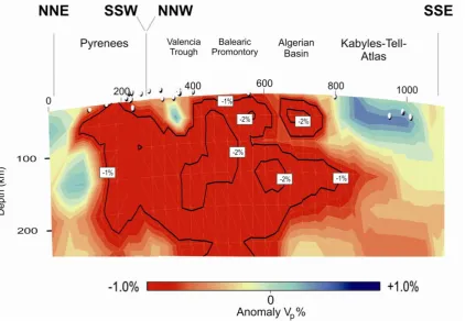
(27) Chapter 1: General Introduction. Figure 1.2: P-wave anomaly of the western-Mediterranean region from the tomography model of Villaseñor et al., 2003 for different depths (145, 200, 260 and 320). Shown are P wave seismic velocity anomalies relative to the 1-D reference model ak135 of Kennett et al. (1995). The blue anomaly under the Rif-Gibraltar-Betic (RGB) (southern Iberia) is the image of the slab. Courtesy by A. Villaseñor.. Low P-wave upper mantle velocities in extensional regions have been traditionally interpreted in terms of compositional crust–mantle transition, and underplating (e.g., Morgan and Ramberg, 1987; Collier et al., 1994; Thybo and Artemieva et al., 2014) but effects of anisotropy, thermal disequilibrium and presence of water in the uppermost mantle have not been fully considered in these basins. Another important observation is the fast velocity anomaly beneath the westernmost Alboran Basin-Gibraltar Arc in the uppermost mantle and surrounding slower velocities below the Iberian plate and the Atlas Mountains. The fast velocity anomaly has been interpreted in terms of a lithospheric slab originated by any of the proposed mechanisms by different authors (e.g., Bezada et al., 2013; Bijwaard and Spakman, 2000; Garcia-Castellanos and Villaseñor, 2011; Calvert et al., 2000; Monna et al., 2013; Piromallo and Morelli, 2003; Schmid et al., 2008) (Fig. 1.2). In this context, the aims of this thesis are: (1) To investigate the lithospheric thickness variation in Iberia, in its eastern margin 8.
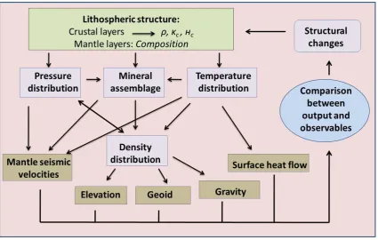
(28) Chapter 1: General Introduction and in North Africa where the geological structures have been affected by the Alpine orogeny, by combining seismological, petrological and geochemical constraints. (2) To analyze possible variations in the composition of the upper mantle, compatible with seismic data and tomography models. (3) To decipher the still unresolved origin of the observed low uppermost mantle Pn velocities beneath the Valencia Trough, Algerian basins and Bay of Biscay, and the range of scenarios that may explain the low seismic velocities observed beneath the crust in the continental margin. (4) To investigate the effects of sublithospheric mantle perturbations of thermal and/or compositional origin imaged by tomography models, and to correlate them with the still unresolved high topography observed both in the Iberian plate and in the Atlas Mountains. In summary, this thesis will help to better understand the upper mantle structure and composition of Iberia, North Africa and the western Mediterranean, and the interpretation of the mantle seismic velocity anomalies imaged by tomograghy models and seismics experiments. Also, this thesis is addressing the question of the high elevation found in the study area and their relation to the sub-lithospheric seismic anomalies imaged from the tomography models. This thesis has been structured in seven chapters: The first chapter (this chapter) illustrates the motivation and the objetives and also introduces a brief review of the study area from a geological and geophysical point of view. The second, third, fourth and fifth chapters deal with the general results in the study area. Each chapter is dedicated to the present-day crustal and upper mantle structure resulting for each geo-transect. The sixth chapter is a general discussion of the results obtained from the modeled geo-transects in the context of the different geodynamic areas. Chapter seventh summarizes the main conclusions from the previous chapters and outlines the possible future work.. 1.2. – Methodology The methodology used in this work is based on the LitMod-2D code (Afonso et al., 2008), which combines geophysical and petrological data to study the crust and 9.
(29) Chapter 1: General Introduction upper mantle structure from a thermal, compositional, seismological and density point of view, within a self-consistent thermodynamic-geophysical framework. The code allows calculating the 2D distribution of temperature, density and mantle seismic velocities down to 400 km depth and the surface heat flow, elevation, and gravity and geoid anomalies. The model follows a forward scheme in which the crustal geometry is constrained from previous seismic studies, and the lithosphere mantle geometry and composition are changed according to the geodynamic setting, xenolith data and tomography models until the best fit is reached (Fig. 1.3).. Figure 1.3: Flowchart indicating the general modeling procedure used in LitMod.. A comparison of model outputs against observed data is used to obtain a lithospheric/sublithospheric model that simultaneously fits all geophysical and petrological observables, and consequently reduces the uncertainties associated with previous thermal approaches. The different crustal and mantle bodies of the model are defined in cross-section and a mesh of triangular finite elements is automatically adjusted to fit their geometry. Each mantle body in LitMod-2D is characterized by its main oxides composition (in weight %) within the Na2O-CaO-FeO-MgO-Al2O3-SiO2 (NCFMAS) system. Stable mineral assemblages are determined through self-consistent thermodynamic calculations via Perplex (Connolly, 1990; Connolly, 2005) and thus, physical properties of each mineral and of the bulk mantle (density, thermal expansion coefficient, elastic parameters, and thermal conductivity) depend not only on 10.
(30) Chapter 1: General Introduction temperature as in previous methodologies, but also on pressure, composition, and phase changes. Once the bulk physical properties are determined for each mantle composition, gravity, geoid, elevation, surface heat-flow and P- and S-seismic velocities are computed and compared with observations. In this work, an augmented-modified version of the Holland and Powell (1998) (revised in 2002) thermodynamic database is used, which takes into account all major phases relevant for the continental crust (Afonso and Zlotnik, 2011). Anelastic effects are computed as a function of the grain size, oscillation period, P-T conditions, and empirical parameters (Afonso et al., 2008 and references therein). In this study, I selected a grain size of 5 mm and an oscillation period of 75 s. The heat transport equation is solved by using the finite elements method in steady-state with the following boundary conditions: 0 ºC at the surface; 1330 ºC at the LAB; and no heat flow across the lateral boundaries of the model. Below the LAB, the algorithm considers a 40 km thick thermal buffer with a temperature of 1400 ºC at its base. This is done to avoid unrealistic discontinuities between a conductive thermal gradient within the lithospheric mantle and an adiabatic thermal gradient within the asthenosphere. The temperature at the base of the model (400 km) is set to 1520 ºC. The temperature gradient below the thermal buffer layer is restricted to 0.35 < dT/dz < 0.50 ºC/km, otherwise the temperature at 400 km depth is modified accordingly (see Afonso et al., 2008 for further details). From the calculated densities for each element of the mesh, free air and Bouguer gravity anomalies in two dimensions are calculated using the algorithm for polygonal bodies of Talwani et al. (1959). The calculation of the geoid height is done following the 2.5D method outlined in Zeyen et al. (2005), such that ∆. 1. .. where ΔN is the geoid anomaly, G is the gravitational constant, go is the normal gravity acceleration at the Earth’s surface and x, y, and z the coordinates of the prism boundaries. According to the principle of isostasy, all regions of the Earth must have a compensation level where the pressure does not vary laterally. Here, it is assumed that the level of compensation is located at the base of the model, roughly coinciding with the 410-km discontinuity. In principle, absolute elevation is computed under the assumption of local isostasy considering a reference column corresponding to a midocean ridge (Afonso et al., 2008). The final formulae that LitMod solves to obtain absolute elevation are similar to those of Lachenbruch and Morgan (1990), where the elevation above (Ea) and below (Eb) the sea level are given respectively, by. 11.
(31) Chapter 1: General Introduction. II. where Ltop is taken at the top of the column, Lbottom is taken at the bottom of the column, ρb (assumed constant) is the density of the mantle at 400 km depth, ρl(z) is the depthdependent density, ρw is the density of seawater (=1030 kg m-3), and II is a calibration constant. In the second, third and fourth profiles the calculation of elevation with flexural support is incorporated. There are deviations from the local isostasy model that are compensated with a flexural isostatic model to evaluate whether they can result in significant topography misfits. Vertical loads relevant to flexure are computed from the lateral changes in lithostatic pressure at the base of the model (400 km depth) resulting from the derived crust and upper mantle structure. Note that a constant pressure at the base of the model implies that the whole transect is under perfect local isostasy. To calculate the deflection from the vertical load distribution, I use an updated version of the code tAo (Garcia-Castellanos et al., 2007). The deflection or vertical displacement of each column, associated with the vertical load, is calculated for a prescribed elastic thickness distribution Te. Larger Te values smooth out larger wavelengths of these vertical displacements, reducing the misfit between the model and the observed topography. See Jiménez-Munt et al. (2010) for details about flexural calculation. Some modifications have been incorporated to the LitMod-2D (used in the third and fourth profiles) code to improve the mantle thermal conductivity calculations and to incorporate sub-lithospheric mantle anomalies. In the first modification, the radiative contribution to lattice thermal conductivity, as described in Grose and Afonso (2013) is added. In the second modification, I consider thermal, compositional, or thermocompositional anomalies relative to the surrounding sub-lithospheric mantle to explain seismic velocity anomalies imaged by tomography models. In the case of thermal anomalies, the code assigns to the anomalous zone(s) the same composition as given to the asthenosphere (usually Primitive Upper Mantle, PUM), and recalculates the relevant physical parameters (density, seismic velocity, phase changes, and thermal conductivity) at P and T+T conditions, T being the prescribed temperature anomaly relative to the surrounding mantle. When the anomaly is compositional, the code calculates the relevant physical parameters at the P-T conditions, considering the prescribed chemical composition. Thermo-compositional anomalies can be related to lithospheric mantle bodies that have been detached and sunk into the asthenosphere and therefore, having a 12.
(32) Chapter 1: General Introduction different temperature and composition than the surrounding asthenosphere. These sublithospheric anomalies can be coupled, when the density anomaly is transmitted to surface elevation, or decoupled, when density anomalies are not transmitted to surface elevation. Therefore, decoupled anomalies do not have effects on calculated isostatic topography but they do on gravity and geoid calculations. To avoid abrupt and unrealistic discontinuities at the LAB, I have added a compositional “buffer” at the base of the lithosphere with an intermediate composition between the subcontinental lithospheric mantle and the Primitive Upper Mantle.. 1.3. – Geological setting For simplicity and to facilitate comprehension of the complex tectonic scenario of the study region, in this section I describe the geological characteristics of the main morphotectonic units relevant to the modeled transects in the study area. The reader is referred to Gibbons and Moreno (2002); Vera et al. (2004); and Vergés and Fernandez (2006), and references therein for a more general description of the geology of the Iberian Peninsula, North Africa and the western Mediterranean.. 1.3.1. – Variscan domain The Variscan Belt, represented by the Iberian massif in the study area, is the result of the collision of several continental blocks formed by the Early Paleozoic fragmentation of a Late Proterozoic supercontinent (Mc Kerrow et al., 2000). The Avalonian plate, one of the continental fragments, was accreted in Ordovician-Silurian times to the Laurentian continent (Caledonian Orogeny). Later on, in DevonianCarboniferous times, the Armorican fragment (Matte et al., 2001) and the Gondwanan continent collided with the Avalonian border of Laurentia, resulting in the Variscan Orogenic Belt and the Late Paleozoic Pangea (Matte, 1986, 2001). The tectonic units forming the present Iberian Massif are: the Cantabrian Zone, the West Asturian Leonese Zone (WALZ), the Galicia Tras-Os-Montes Zone (GTMZ), the Central Iberian Zone (CIZ), the Ossa-Morena Zone (OMZ), and the South Portuguese Zone (SPZ). The Cantabrian Zone (CZ) and the South Portuguese Zone (SPZ) represent opposite foreland fold and thrust belts of the orogen (to the north and to the south respectively). The Galicia Tras-Os-Montes Zone, in the northwestern part of the Iberia, consists of a pile of allochthonous tectonic units with high-pressure metamorphism and rocks including 13.
(33) Chapter 1: General Introduction ophiolites (Arenas et al., 1986, 1997 and Ribeiro et al., 1990a). The suture is placed beneath the mafic and ultramafic complexes of this zone, and is rooted towards the Atlantic margin (Matte, 1986 and Martınez Catalan et al., 1997). In the northern and the southern boundaries of the Ossa-Morena Zone (OMZ), two contacts of probable suture character have been recognized. The suture between the OMZ and the Central Iberian Zone (CIZ) is a complex tectonic unit called the Badajoz-Cordoba Shear zone or Central Unit (Simancas et al., 2001), which includes some retroeclogites and amphibolites with oceanic chemical signature (Simancas et al., 2003). The suture between the OMZ and the SPZ (the Beja-Acebuches ophiolite) is based on the existence of a strip of oceanic amphibolites (Quesada et al., 1994) and on the accretionary prism with slices of oceanic metabasalts (the Pulo do Lobo Unit) (Silva et al., 1990).. 1.3.2. – Alpine domain To the North of the Iberian Peninsula, the Pyrenean fold-thrust belt is a classic example of continent–continent collision that initiated by late Senonian and ceased at middle Oligocene. With a length of about 450 km, the belt runs in an E–W direction, from the Gulf of Lyon to the E to the Gulf of Biscay to the W (see Fig. 1.1 for location). The orogen is an asymmetrical and bivergent V-shaped continental wedge, the northern wedge being formed by a series of northward directed thrusts on top of the European plate, while the southern wedge, on top of the Iberian plate, is wider and shows greater displacement and shortening. From North to South the Pyrenean orogen comprises the Aquitaine foreland basin; the North Pyrenean thrust system; the axial zone, mainly composed by metamorphic and igneous rocks; the South Pyrenean thrust system and the Ebro foreland basin (e.g., Muñoz et al., 1986; Muñoz, 1992; Vergés et al., 1995; Muñoz, 2002). At crustal and lithospheric levels, the collision caused a thickening of the crust from about 32 km beneath the Ebro Basin to almost 60 km under the axial zone of the Pyrenees, (ECORS Pyrenees Team, 1988; Torné et al., 1989) while the LAB deepens from about to 90–110 km to 140–160 km depending on authors (e.g., Zeyen and Fernandez, 1994; Pous et al., 1995; Roca et al., 2004; Gunnell et al., 2008; Campanyà et al., 2012). Coinciding with the cessation of the main compressive stage along the Pyrenees, which also resulted in the formation of the Catalan Coastal Ranges, deformation migrated to the south and south east into the Valencia Trough and Algerian Basin domains (Vergés and Sàbat, 1999). Unlike the Pyrenees, the Catalan Coastal Ranges (see Fig. 1.1 for location) do not show significant thickening either of the crust or of the lithospheric mantle. The Cantabrian Mountains represent the westward continuation of the Pyrenees 14.
(34) Chapter 1: General Introduction along the northern coast of Iberia. They are characterized by south-directed thrusts and associated folds, involving the Paleozoic basement along most of the belt. Northverging structures are present in the easternmost part of the Cantabrian Mountains, continuing to the west along the North-Iberian margin. Several deformation stages affected the area from the Late Palaeozoic to the Cenozoic (Perez-Estaun and Bea, 2004; Barnolas and Pujalte, 2004; Vera et al., 2004). The oldest event that is extensively recognized is the Variscan orogeny, which resulted from the continental collision between Laurassia and Gondwana at the end of Carboniferous times (e.g., Pérez-Estaún et al., 1991; Nance et al., 2012). After the Variscan orogeny, a rifting episode took place during the Late Paleozoic-Early Mesozoic, giving rise to localized Permo-Triassic basins. This event was followed by an important period of crustal extension related to the opening of the North Atlantic Ocean and the Bay of Biscay during Late Jurassic and Early Cretaceous times, which culminated in sea-floor spreading along the western margin of Iberia in the mid to Late Cretaceous, finishing in the Campanian (A33o) (e.g., Srivastava et al., 1990; Sibuet and Collete, 1991; Fernández-Viejo et al., 2005). Finally, N-S to NW-SE compression affected the North Iberian (Cantabrian) passive continental margin, whose geometry and inherited structures conditioned the formation of a double crustal indentation and the uplift of the Cantabrian Mountains in Eocene to Oligocene times (e.g., Alonso et al., 1996; Pulgar et al., 1996; Ferrer et al., 2008). The lower crust from the Cantabrian margin is underthrusted below a detachment level and protrudes into the Iberian crust forcing the north-directed subduction of its lower half (Pulgar et al., 1996; Gallastegui, 2000; Pedreira et al., 2003, 2007).. 1.3.3. – The Central System and adjacent foreland basins The Central System is a linear ENE-WSW mountain chain extending along 300 km in the central part of the Iberian Peninsula. It was uplifted as a crustal pop-up during Oligocene - Miocene bounded by NE-SW-trending reverse faults (Ribeiro et al., 1990b; Banks and Warburton, 1991; Vegas et al., 1990; de Vicente and Muñoz-Martín, 2013). The uplifted basement corresponds to high-grade Upper Precambrian gneisses and Variscan granites in the western part, and to low-grade Lower Palaeozoic metasediments in the eastern part (Fernández Casals et al., 1976). The Central System is bounded by two large sedimentary basins in the central part of Iberia: the Duero Basin to the NW and the Tagus Basin to the SE. The Duero Basin began to form during the Late Cretaceous as a continental shelf of the Cantabrian Margin. During the Eocene, the northern part evolved as a foreland basin linked to the formation of the Cantabrian Mountains (Alonso et al., 1996), whereas the southern border acted as the foreland 15.
(35) Chapter 1: General Introduction basin of the Central System during the early Oligocene-Miocene (Capote et al., 2002). Depocentres are related to the active borders of the basin, the sedimentary thickness reaching maximum values of 2500 m (Alonso et al., 1996). The Tagus Basin is a foreland basin related to the interaction between the Alpine tectonic uplift of the Central System and the transpressive regime along the Iberian Range. The basin is filled with Late Eocene to Late Miocene continental deposits with maximum thickness of 3500 m along its NE-SW border (Gómez-Ortiz et al., 2005).. 1.3.4. – The Betic–Rif orogen and West Mediterranean basins The southern margin of Iberia underwent a complex tectonic evolution about which there is a very active debate (e.g., Rosenbaum and Lister et al., 2002; Faccenna et al., 2004; Spakman and Wortel, 2004; Carminati et al., 2012; Vergés and Fernandez, 2012; van Hinsbergen et al., 2014; Casciello et al., 2014; Chertova et al., 2014). According to Vergés and Fernandez (2012), the Betic–Rif orogen was formed as a consequence of SE-dipping subduction of the western domain of the Ligurian–Tethys lithosphere beneath Africa from Late Cretaceous to middle Oligocene, followed by a fast NW and W slab roll-back. In the Algerian domain, the subduction of the LigurianTethys lithosphere towards the NW, and the SE- and E-directed retreating produced the opening of the Valencia Trough, the Algerian Basin, and the Tyrrhenian Sea. Many of the other models assume a unique subduction polarity of the Ligurian-Tethys lithosphere, directed to the NW and claiming for a S-, SE- and SW-directed slab retreating with a trench rotation of ~180º in the Betic segment (e.g., Rosenbaum and Lister et al., 2002; Faccenna et al., 2004; Spakman and Wortel, 2004; van Hinsbergen et al., 2014; Chertova et al., 2014) (Fig. 1.4). Independently on the model evolution, the Betic-Rif orogen comprises several major tectonic domains: a) the Guadaquivir and Gharb forelands basins; b) the ENE– WSW trending External units, separated in Prebetic and Subbetic domains; c) the Gibraltar Flysch Units around the western side of the thrust belt; and d) the HP/LT metamorphic complexes of the Internal units. The NW and W retreat of the LigurianTethys slab produced the thrusting of the Internal Betics domain over the Iberian and Maghrebian passive continental margins. In this context, the Alboran Basin formed as a back-arc basin and it is characterized by a thin continental crust in its western part, evolving towards the east to a thin continental crust modified by arc magmatism, a magmatic-arc crust, and oceanic crust in its easternmost part and towards the Algerian 16.
(36) Chapter 1: General Introduction Basin (Torne et al., 2000; Booth-Rea et al., 2007).. Figure 1.4: An illustration of rollback as portrayed in the three different reconstruction scenarios from Chertova et al., 2014. Scenario 1 (Spakman and Wortel, 2004) and scenario 2 (Faccena et al., 2004) assume a unique subduction polarity but start from different initial subduction zone (short and long respectively). Scenario 3 (Vergés and Fernandez, 2012) shows two opposite dipping subductions. Dashed lines represent proposed transform fault regions. The triangular zone between the transform zones of Scenario 1 depicts the lithosphere that rolls back toward the east Kabylides (Spakman and Wortel, 2004).. In the Valencia Trough and the Algerian basins, structures are related to the Tethyan subduction mainly developed between the Late Oligocene and Late Miocene (Roca et al., 2004). The crustal and lithosphere geometry is mainly the result of the south-eastward retreat of the Tethys–Maghrebides subduction zone (Doglioni et al., 1997; Carminati et al., 1998; Vergés and Sàbat, 1999). The south-eastward retreat of the slab resulted in a widespread back-arc extension which thinned the southeastern margin of the Iberian plate and caused the opening of the Valencia and Algerian basins. In the Valencia Trough Basin extension lasted from Late Oligocene to Langhian period, whereas the opening of the Algerian Basin began later (latest Early Miocene–Middle Miocene) and ended during the Tortonian, when remnants of the southern Iberia continental margin (the Kabylies) accreted with the African plate. The accretion of the Kabylies led to the development of the Tell thrust system in the northern African domain (Cavazza et al., 2004; Roca et al., 2004). Back-arc extension resulted in thinning of the crust and lithosphere mantle. In the Valencia Trough Basin the crust thins from 20 to 22 km near the Iberia coastline to 14 km at its central parts (e.g., Pascal et al., 1992; Torne et al., 1992; Gallart et al., 1994; Vidal et al., 1998), while the LAB shallows to as much as 65 to 60 km, depending on the authors (e.g., Zeyen and Fernandez, 1994; Ayala et al., 1996; Roca et al., 2004). A slight thickening of the crust and lithosphere is observed in its southeast margin, along the Balearic Promontory, where the base of the crust and LAB achieves values of about 20 and 90 km, 17.
(37) Chapter 1: General Introduction respectively. This thickening is partly explained by the fact that the area was affected by the orogenic activity recorded along the south-eastern passive margin of Iberia from Late Oligocene to Middle Miocene, which gave rise to the observed WNW–ENE verging folds and thrust that involve the Mesozic cover and Paleogene to Middle Miocene sediments (e.g., Sàbat et al., 1988; Roca et al., 1999). The geometry of the crust and lithosphere mantle is not so well constrained along the Algerian Basin owing to the scarcity of geophysical experiments. In the northwest part of the Algerian Basin the available seismic refraction profile of Hinz (1972) shows that the crust is partly oceanic with a thickness of about 5 km. This value is consistent with that observed in the ESCI—Valencia seismic reflection profile (Sàbat et al., 1997; Vidal et al., 1998). Roca et al. (2004) show that the LAB attains depths of about 50 km in the central parts of the basin, abruptly deepening near the African coastline to values of 175–185 km. From late Miocene, the protracted slow convergence between the African and Eurasian plates (~ 6 mm/year; Argus et al., 1989; DeMets et al., 1994) has caused intraplate compressive stresses in the whole area, which have resulted in compressive reactivation of previous faults. Active faulting combining ENE–WSW reverse faults and NW–SE right lateral strike-slip faults is particularly important in the Algerian margin as shown by numerous destructive earthquakes (El Asnam, 1980, Ms =7.3; Boumerdès, 2003, Ms = 6.7). The observed compressive deformation could indicate the development of a new African-Eurasian boundary along the Algerian margin, where the thin Algerian oceanic lithosphere is in contact with the thicker African continental lithosphere (e.g., Deverchere et al., 2005; Domzig et al., 2006).. 1.3.5. – The Atlas Mountains and the Sahara platform The Atlas Orogen is an intracontinental mountain belt uplifted in the foreland of the Rif and Tell Ranges, which extends more than 2000 km through Morocco, Algeria and Tunisia. The Atlas Mountains consist of two main branches, the E-trending High Atlas, with summits of 4000 m, and the NE-trending Middle Atlas, which reaches 3000 m. Foreland basins are poorly developed and the synorogenic sediments are only locally preserved, and usually are few hundred metres thick. These chains are fold-thrust belts formed during the Cenozoic from inversion of intraplate Triassic–Jurassic transtensional troughs related to convergence between Africa and Europe (Laville et al., 1977; Dutour and Ferrandini, 1985; Gorler et al., 1988; Fraissinet et al., 1988; Medina and Cherkaoui, 1991; El Harfi et al., 1996; Morel et al., 1993, 2000, etc.). In addition, rifting-related Triassic and Jurassic igneous rocks are widespread (Hailwood and Mitchell, 1971). Tectonic shortening across the Atlas Mountains is modest. Teixell et al. (2003) 18.
(38) Chapter 1: General Introduction calculated values ranging from 15% to 24% of the High Atlas, whereas Gomez et al. (1998) estimated it in 15% in the central Middle Atlas. Modest crustal tectonic shortening and thickening contrasts with the high topography observed suggesting a mantle contribution to uplift (Teixell et al., 2003). The internal deformation structures in the Middle Atlas are oriented NE-SW, parallel to the general trend of the chain. At its northern boundary, the Middle Atlas plunges under the Neogene sediments of the Saiss Basin, the foreland basin of the Rif orogen. The northern half of the Middle Atlas has a tabular structure only disrupted by minor normal and thrust faults (e.g., Termier, 1936; Duée et al., 1977; Fedan, 1988; du Dresnay, 1988; Charroud, 1990 and Gomez et al., 1996, 1998). The structure of the High Atlas is characterized by folds and thrusts oriented approximately NE–SW, slightly oblique to the general ENE–WSW trend of the chain (Schaer, 1987; Laville, 1985; El Kochri and Chorowicz, 1995; Teixell et al., 2003).. 1.3.6. – Neogene and Quaternary volcanism The presence of Neogene and Quaternary alkaline volcanism is widespread in Iberia, North Africa and western Mediterranean (see Figure 1.1). The main volcanics areas for this study are located in the Valencia Trough, Calatrava Volcanic Province, Alboran Basin and in the Atlas Mountains. In the Valencia Trough magmatism is characterized by two volcanic cycles which are clearly separated in time and by their petrological setting (Martí et al., 1992). The first volcanic cycle, being of Chattian-early Burdigalian age, is characterized by calc-alkaline andesitic and pyroclastic rocks, while the second cycle, of Tortonian to Recent age, is characterized by poorly differentiated alkali-basalts. Close to the southern border of the Tagus Basin there is the Calatrava Volcanic Province (CVP) extending over an area of 5500 km2 (Ancochea, 1982). Late Miocene to Quaternary magmatism with intraplate (OIB) affinity occurring in CVP often carries nodules that provide direct information on the composition of the mantle. Geochemical and isotopic analyses of ultramafic xenoliths show a wide range of compositional heterogeneities due to both tholeiitic melts or subducted oceanic crust with metasomatic events of alkaline melts similar to the hosting lavas (LREE, Pb, Th and U enrichments in clinopyroxenes and whole rock HIMU-like signature respectively) (e.g., Cebriá and López-Ruiz, 1995; Bianchini et al., 2010; Villaseca et al., 2010). In the Alboran Basin, the extensional evolution was accompanied by broadly distributed volcanism ranging from early Oligocene tholeiitic through calc-alkaline series related to subduction, to middle-late Miocene tholeiitic through calc-alkaline and alkaline series related to lithosphere thinning (e.g., Duggen et al., 2004). In addition, 19.
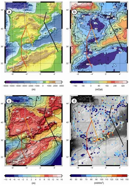
(39) Chapter 1: General Introduction Tertiary and Quaternary alkaline volcanism (Harmand and Catagrel, 1984) has been identified in the Middle Atlas, the Moroccan Meseta, the High Plateaux, the northern part of the High Atlas, and in the Anti-Atlas. The upwelling of hot asthenospheric mantle controlled by various tectonic events (intraplate extension, rifting, slab retreat or lithospheric delamination; e.g. Carminati et al., 2012) caused partial melting at the base of the metasomatised lithosphere, and the subsequent episodic emplacement of small amounts of sodic alkaline lavas such as in the Middle Atlas and Central Morocco volcanic provinces (Bosch et al., 2014).. 1.4. – Geophysical data 1.4.1. – Global geophysical data Regional geophysical data sets (elevation, gravity, geoid height and surface heat flow; Fig. 1.5) were collected from different data sources. Elevation data come from ETOPO1 (Amante and Eakins 2009), a global elevation model of the Earth surface of 1x1-min arc resolution (Fig. 1.5a). In the study area, maximum average elevation values of about 2000 m are attained in the Pyrenees and in the Cantabrian Mountains, 15002000 m in the Betic Cordillera, 650 m in the Rif Cordillera and ~2700 m at the highest peak of the Middle Atlas Mountains. The Duero and Tagus basins are flat areas with average elevations of ~800 m and ~600 m, respectively. The minimum are reached in the Algerian Basin, Bay of Biscay (Cantabrian Sea) and the Alboran Sea where the ocean floor deepens to as much as -2900 m, -4500 m and -1900 m, respectively. Onshore Bouguer anomalies (Fig. 1.5b) were obtained from a recent compilation of gravity data in the Iberian Peninsula (Ayala, 2013) in the framework of the Topo-Iberia Project. Bouguer anomalies offshore and onshore in North Africa were computed from the free-air global satellite altimetry data model V16.1 (Sandwell and Smith, 1997, updated 2007) to which a full 3 D topographic correction has been applied with the software FA2BOUG (Fullea et al., 2008) using a density reduction of 2670 kg m− 3. Minimum Bouguer values of −120 mGal are achieved below the Pyrenees and Rif Mountains. Less than -100 mGal are found in the Central System, the Betic Cordillera, and the Kabylies–Tell–Atlas Mountains. Maximum values are recorded below the Valencia Trough (100 mGal), Algerian Basin (200 mGal), Bay of Biscay (300 mGal) and the Alboran Sea (100 mGal).. 20.
(40) Chapter 1: General Introduction. Figure 1.5: Geophysical data. a) Elevation map from ETOPO Global Data Base (V9.1) (http://www.ngdc.noaa.gov/mgg/fliers/01mgg04.html). b) Bouguer anomaly. Onshore, in the Iberian Peninsula, the Bouguer anomaly comes from Ayala (2013). Offshore and Africa Bouguer anomaly has been calculated from the free air anomaly by Sandwell and Smith (1997) using Fullea et al. (2008).. 21.
(41) Chapter 1: General Introduction. Contour interval is 40 mGal. c) Geoid anomaly map from EGM2008 Global Model (Pavlis et al., 2008). Long wavelengths (>5000 km) have been removed by subtracting spherical harmonics up to degree and order 8 from the total geoid. Contour interval is 1 m. d) Surface heat flow measurements from Fernandez et al. (1998), Marzán Blas (2000) and International Heat Flow Commission global data set for Algeria (http://www.heatflow.und.edu/index2.html). Colors of solid circles indicate heat flow values. Thick lines locate the modeled geo-transects: 1) black line; 2) grey line; 3) orange line and 4) red line.. Geoid height data (Fig. 1.5c) was taken from EGM2008 (Pavlis et al., 2008) and filtered up to degree and order 8, to retain only a residual geoid anomaly that reflects the density distribution within the lithosphere and the uppermost sub-lithospheric mantle (~400 km depth). Most of Iberia shows geoid height values between 8 and 11 m, with maximum values in the Betic Cordillera and the Tagus Basin and in the Pyrenees. In the eastern Iberia we observe values ~7 and ~5 m in the Valencia Trough and Algerian basins, respectively. The minimum geoid values are in the oceanic basins, reaching -5 m in the Bay of Biscay. Surface heat flow data were compiled from different datasets (International Heat Flow Commission data set; Fernandez et al., 1998; and Marzán Blas et al., 2000) which also incorporates the sea-floor heat flow measurements in the Valencia Trough Basin from Foucher et al. (1992) and from Rimi et al. (2005) in Morocco. Fig. 1.5d shows the location and values of available measurements. The heat flow onshore Iberia varies between 45 and 65 mW/m2. As observed the data exhibit a wide scatter around a mean value of 70–80 mW/m2 in the Valencia Trough and the Balearic Promontory, with a good coverage in some areas, particularly in the Algerian Basin, Alboran Sea and onshore Algeria. Seafloor heat flow measurements carried out in the western Algeria Basin and in the Alboran Sea show values ranging from 90 to 120 mW/m2 (Marzán Blas, 2000). Heat flow values exceeding 70-80 mW/m2 are located at SW-Iberia (SouthPortuguese Zone), NW-Iberia (Centro-Iberia Zone) corresponding to local thermal anomalies, and north Morocco and east-Algeria.. 22.
(42) Chapter 2: The Pyrenees– Balearic Promontory– Kabyles–Tell–Atlas geo– transect (first profile). 23.
(43) Chapter 2: Pyrenees–Balearic Promontory–Kabyles–Tell–Atlas. 24.
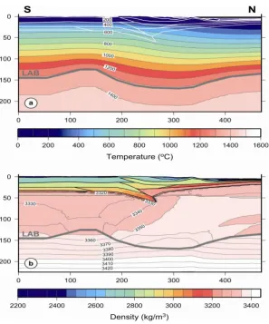
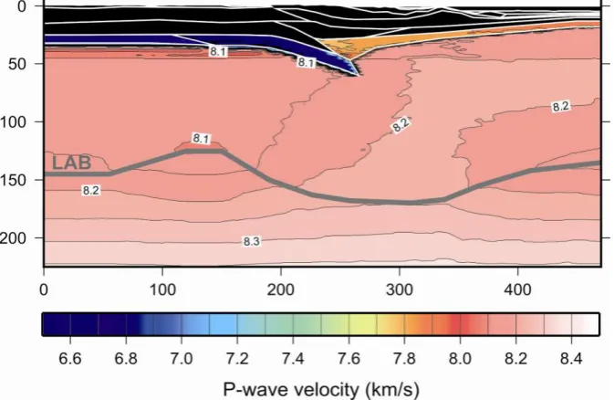
(44) Chapter 2: Pyrenees–Balearic Promontory–Kabyles–Tell–Atlas Most of the materials of this chapter relative to data gathering, aims, modeling technique, results and discussion, have been published in the Elsevier international journal Gondwana Research (Carballo et al., 2015a). The present-day crustal and lithospheric mantle structure in SE-Iberia and the western Mediterranean is the result of compressional tectonics with collision/subduction in the former Eurasia–Iberia (Pyrenees) and in the Iberia–Africa (Tell–Atlas) plate boundaries, and back-arc extensional tectonics in the Neogene western Mediterranean. This complex tectonic evolution affected Paleozoic, Mesozoic and Tertiary domains with late-Hercynian plutonism in the Pyrenees (Michard-Vitrac et al., 1980; Fourcade and Allègre, 1981), Neogene volcanism along the Iberian–Mediterranean margin (Martí et al., 1992; Wilson and Bianchini, 1999; Lustrino et al., 2011), and generation of oceanic crust in the Algerian Basin (Sàbat et al., 1997; Vidal et al., 1998; Booth-Rea et al., 2007). Unraveling the crust and lithosphere structure of the Alpine-Mediterranean region has been the subject, in the last decades, of numerous geological and geophysical studies that were summarized in eight regional geo-transects in the TRANSMED Atlas (Cavazza et al., 2004). In this Chapter, I present a new modeling of the TRANSMED-II geo-transect with a N–S trend crossing the southern part of the Aquitanian Basin, the Pyrenees and the northern part of the Eastern Ebro Basin. From there it continues with a NNW–SSE direction through the southern part of the Eastern Ebro Basin, the Catalan Coastal Ranges, the Valencia Trough Basin, the Balearic Promontory, the Algeria Basin, the North African margin, the Kabylies, and ending at the Tell–Atlas mountain range.. 2.1. – Crustal geometry from previous studies The crustal geometry is well known from the numerous deep seismic reflection and wide-angle/refraction profiles collected during the last decades (Fig. 2.1 and 2.2). The compilation of available crustal structure is summarized in the TRANSMED II transect (Roca et al., 2004). Original seismic data come from ECORS—Central Pyrenees (ECORS Pyrenees Team, 1988), ESCI—Catalánides (Gallart et al., 1994), ESCI—Valencia (Vidal et al., 1998), Hinz (1972) and ALE-4 (an industry profile) (see Fig. 2.1 for location of profiles). The Moho depth varies from 32 to 35 km beneath the Aquitanian Basin to more than 50 km in the Pyrenees and 36–32 km in the Ebro Basin and the Catalan Coastal Ranges. Towards the Valencia Trough, the Moho rises up to 16– 18 km deepening to 22–25 km in the Balearic Promontory, whereas beneath the Algerian Basin the Moho lies at 10–12 km depth. In the Algerian margin, the Moho 25.
(45) Chapter 2: Pyrenees–Balearic Promontory–Kabyles–Tell–Atlas depth increases to values of about 30 km close to the shoreline and according to Roca et al. (2004) it deepens down to 40 km depth beneath the Tell–Atlas mountains.. Figure 2.1: Geological map of the study area showing the principal geological domains of Iberia, Western Mediterranean and North Africa (modified from Vergés and Sàbat et al., 1999). Thick gray line locates the modeled transect. Upper right inset shows the main topography and bathymetry features of the study area in which is located: Black line-model transect; Deep blue—ECORS Pyrenees; Yellow— ESCI Catalanides; Green line—ESCI València; Pink line: ALE-4 and dark gray-other seismic experiments (Diaz et al., 2013).. The resulting crustal structure (Fig. 2.2) shows minor differences with TRANSMED-II transect. However, beneath the Kabyles–Tell–Atlas region, the modeled crust is up to 10 km thinner. In the Balearic Promontory, our results coincide with TRANSMED-II although the crust is slightly thinner with respect to Vidal et al. (1998). Density and thermal conductivity values for crustal bodies have been taken from previous studies (e.g., Fernandez et al., 1990; Torne et al., 1992, 1996; Zeyen and Fernandez, 1994). Radiogenic heat production has been taken from a global compilation carried out by Vilà et al. (2010). Parameters used in the crust are summarized in Table 2.1. 26.
Figure


+7


Documento similar
MD simulations in this and previous work has allowed us to propose a relation between the nature of the interactions at the interface and the observed properties of nanofluids:
The expansionary monetary policy measures have had a negative impact on net interest margins both via the reduction in interest rates and –less powerfully- the flattening of the
Of special concern for this work are outbreaks formed by the benthic dinoflagellate Ostreopsis (Schmidt), including several species producers of palytoxin (PLTX)-like compounds,
50 The goal is to help people to reach an optimum level in the dimensions of psychological well- being: environmental mastery, personal growth, purpose in life,
De todos modos, gracias por tu amistad, gracias por tu confianza, gracias por tu apoyo, gracias por tu comprensión, gracias por tus ánimos y gracias por tu energía inagotable durante
In the previous sections we have shown how astronomical alignments and solar hierophanies – with a common interest in the solstices − were substantiated in the
While Russian nostalgia for the late-socialism of the Brezhnev era began only after the clear-cut rupture of 1991, nostalgia for the 1970s seems to have emerged in Algeria
The concept of breakdown probability profile is useful to describe the break- down properties of any estimate obtained through resampling, not just the bagged median or the
