Hierarchical Spatial Reasoning Applied to Spatial Data Infrastructures
10
0
0
Texto completo
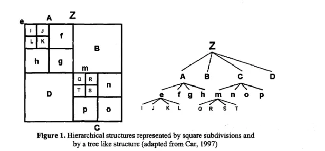
(2) MSJA Nationa/ Conference 2000. by Rajabifard el al. (2000) that the GSOI initiative is going to face the same challenges as other SDI initiatives in its future development and implementation phases. Reasons suggested for the limited support from certain nations, regional organisations and other relevant institutions, include lack of awareness of the value of SOIs, the incompatibility of the current conceptual and organisational model with the perceived needs of the respective cornmunities, and the complexity of different issues such as diverse political, cultural and economical positions. One way to optimise support is to increase the level of understanding and awareness of people (both users and producers of spatial data, and concerns of relevant politicians) about the nature and the value of SOl concepts in general, and the relationships between different levels of SOIs in particular. HSR provides an expandable framework to demonstrate the concept of SOl and represent complexities of the different SOl levels based on hierarchical principIes. This provides a model of the flow on effects achievable through SOl by embracing a hierarchical concept. This paper attempts to demonstrate the hierarchical relationships between different political/administrative levels of SOIs. It explores the applicability of HSR as a theoretical framework to describe the multi-dimensional nature of SOIs in which to explore the benefits of this hierarchy to increase awareness of SOIs. However, due to the complex nature of SOIs, this paper also attempts to show that current properties of HSR are insufficient to demonstrate fully the dynamic and multi-dimensional nature of SOIs. With this aim, this paper wiIl review theconcept of spatial hierarchy and its properties and then discuss the concept of an SOl hierarchy by introducing different views on the nature of this hierarchy. The paper concludes by examining how current hierarchical theory can be extended to incorporate different levels of SOl initiatives.. BIERARCmCAL SPATIAL THEORY In the past much research has been conducted toward maximising the efficiency of computational processes by using hierarchies to break complex tasks into smaIler, less complex tasks (Car 1997, Timpf 1998). Hierarchical principIes are used in many different disciplines to break complex problems to sub problems that can be solved in an effective manner. Examples of hierarchical applications inc1ude classification ofroad networks (Car 1997), development ofpolitical subdivisions and land-use classification (Volta and Egenhofer 1993). The complexity of the spatial field as highlighted by Timpf (1998) is primarily due to space being continuous and viewed from an infinite number of perspectives ata range of scales.. Definition of llierarchy Koestler (1968), as cited by Car (1997), used the term hierarchy for a tree-like structure of a systern which can be subdivided into smaIler sub-systems, which in turn can be further subdivided into smaIler sub-systems, and so on. In Figure 1, an example of a hierarchical structure is given, where each new square can be divided into· a se! of four smaIler squares. ABCO consists of four subsquares. This can be recursively subdivided as long as subdivision makes sense. This hierarchical arrangement can also be represented as a tree.. 392.
(3) MSIA Nalional Conference 2000. e. A. z. z ~ A. B. e. D. ~~ ~~. IJ. e. fghmno KL. p. QRST. e Figure 1. Hierarchical structures represented by square subdivisions and by a tree like structure (adapted from Car, 1997). Hierarchies are usually distinguished by their functions, which produce different types of hierarchies. Timpf (1998) recognised aggregation, generalisation and filtering as the three most important functions to produce three different types of hierarchies. The aggregation hierarchy is built by aggregating objects. The generalisation hierarchy defines how classes are related to more generic super, or higher order, classes. The filter hierarchy filters objects according to a criterion.. Purpose and Levels of a Hierarchical Structure There are good reasons why hierarchies develop and persist. Decreasing the processing time (Pattee 1973, Car 1997) is one reason to introduce a hierarchy into a system: a process being a sequence of actions performed in a particular way and leading to some result, and the processing time is thought of as time needed either for development or evolution of a system. A hierarchically structured system evolves much faster than a non-hierarchical system containing the same number of elements (Simon 1973). Increasing the stability of any system is another reason to form hierarchies (Pattee 1973). AIso, hierarchies break down the task into manageable portions, and enhance the potential for parallel processing (Timpf el al. 1992). The hierarchical approach was especially adopted in the description of complex dynamic systems (Mesarovic el al. 1970 as cited by Timpf 1998), which Simon (1981) states have several advantages to a hierarchical structure. With regard 10 the levels in a hierarchical structure, a set is divided into subsets or levels. A level is described by criteria determining which elements of the initial set belong to this level, and in turn, how this level is related to other levels in a hierarchy. The number of levels determines the depth of the hierarchy. The number of elements on each level determines its span and in turn the span of the tree.. HierarchicalFleasoning Hierarchical reasoning is any reasoning process that applies hierarchy either to sub-divide the task, problem, process or space. Hierarchical reasoning adopts the principIe of using the least detailed representation to answer a question. All data are inherently imprecise, but decisions do not require perfect information, instead information that is sufficiently precise (Timpf and Frank 1997). Hierarchical Spatial Reasoning (HSR) is defined by Car (1997) as part of the spatial information theory that utilises the hierarchical structuring of space for efficient reasoning. It is only recently, through the works ofCar (1997) for way-finding, Glasgow (1995) for spatial planning and Frank and Timpf (1994) devising the intelligent zoom, that this theory has started to be applied in the spatial industry.. 393.
(4) MSlA Nationa/ Conference 2000. Principies of HSR The framework supporting HSR has three important components - representation, properties and applications. Hierarchies have been represented using alternative methods: Coffey (1981) devised triangles to represent a hierarchical structure; Car (1997) illustrates how triangles can also be represented as a tree-like structure. Although there are different representations of hierarchically organised systems, all provide the same function to breakdown the complexity of problems into smaller sub systems that can be efficientIy handled and modelled. In the past HSR research has focused on zero and one-dimensional structures to model urban systems (as points), road and drainage networks (as lines), and to a certain extent, to model simple bidimensional objects such as square polygons in quad-trees. RecentIy, research on HSR has focused on three-dimensional structures to break down the complexities of polygons in the case of Australian administrative boundary design (Eagleson et al. 1999). From this research it has become evident that the properties required to mode1 polygon hierarchy are more complex than those utilised for the modelling of points or networks. Properties. of Hierarchies. Hierarchies in various phenomena, both natural and artificial, have properties specific 10 a particular context, but they also have cornmon properties. These cornmon properties are general relationships among structure, movement and function that are independent of their specific context (Car 1997). Some of the properties of a hierarchical structure that are relevant to the understanding of hierarchies in general, and spatial hierarchies in particular, are as follows: •. Part-Whole Property. In a hierarchy, an element on a higher level consists of one or more elements on the lower level. In view of a part-whole relationship, a higher level is a whole and a lower element is-Íts part (Car 1997). For example, in Figure 1, quadrangle A is a whole made up of quadrangles e, f, g, and h. Similarly, A is also part of quadrangle Z.. •. Janus-Effect. An element at a hierarchical level has two different faces, one looking toward wholes in a higher level and the other looking toward parts in a lower level. This property was introduced by Koestler (1968, cited by Car 1997) as a fundamental property of all types of hierarchy. In Figure 1, each quadrangle is directly related to both above and below level quadrangles. Thus, e faces A but also 1, J, K, and L.. •. Near Decomposability. The third fundamental property of hierarchy is called near decomposability (Simon 1973). It is related to the nesting of systems within larger sub-systems, and is based on the fact that interactions between various kinds of systems decrease in strength with distance. Components that are closer to each other interact more strongly than components that are far apart, many of them being at the same level. The definition of this property does not refer to whether elements on the same level should or should not be closer and have more interaction than elements in other levels. In Figure 1, elements such as J or K are closer to A than to other elements on the same level such as T or Q. In the tree structure part ofthe same diagram, it is clear how elements within the same level do not necessarily interact with themselves. It is believed, and will be discussed later, that elements within the same level in the hierarchy should have a way to cornmunicate or interact in a better way than what is already present amongst levels.. Other than properties, hierarchies may also have special functional features such as uniqueness in particular roles. A feature such as this uniqueness may distinguish one level of hierarchy due to its inter ..relatedness with the other levels oí hierarchy. This feature is known as particularity to the system of hierarchies.. 394.
(5) MSIA NationaJ Conference 2000. SPATIAL DATA INFRASTRUCTURE Spatial Data Infrastructure (SOl) is an initiative intended to create an environment that enables a wide variety of users, who require access to and retrieval of consistent data sets, of a certain area covered by the SOl, in an easy and secure way. It can also be viewed as a tool to provide an environment in which all stakeholders, both users and producers of spatial data, can cooperate with each other and utilise technology in a cost-effective way to better achieve the objectives at the appropriate political/administrative leve!. SDIs are now recognised as a central component in supporting an information society. Countries and states are cornmitted to fmding workable strategies and models to support SOl initiatives due to the potential that SDIs offer for managing our natural and built environment in an information society. SOIs have become a crucial tool in determining the way in which spatial data are usedthroughout an organisation, a nation, different regions and the world. They allow the sharing of data, which enables users to save resources, time and effort when trying to acquire new data sets by avoiding duplication of expenses associated with generation and maintenance of data and their integration with other data sets. Central to achieving efficient and effective use of spatial information to meet organisational and business objectives is thus optimising the potential of SDIs to support spatial information interactions. However, to empower SDI framework implementation and SOl optimisation in the spatial information industry, technical and institutional issues of access to useable data need to be addressed. SOl is defined differently by many stakeholders trying to capture the nature of SDI. For example, the Federal Geographic Oata Cornmittee (FGOC 1997) defines the United States' national SOl as an umbrella of policies, standards, and procedures under which organisations and technologies interact to foster more efficient use, management, and production of geospatial data. It further explains that SOIs consist of organisations and individuals who generate or use geospatial data and the technologies that facilitate use and transfer of geospatial data. Another example is the Australian and New Zealand Land Information Council (ANZLIC 1998) that defines a nationai SDI as comprising four core components: an institutional framework, technical standards, fundamental datasets, and clearing house networks. These definitions together with other attempt (McLaughlin and Nichols 1992, Executive Order 1994, European Commission 1995, GSOI 1999) provide a useful base for understanding of SOL But, individually they are unable to demonstrate different aspects of SDIs. Individual SOIs are designed to meet the criteria defined by stakeholders from particular cornmunities. While these criteria meet the objectives of the irnmediate SDI, they remain isolated unless integrated with the objectives of related SDIs and the broader SDI network. In other words, current understandings of SDI have resulted in fragmentation of the objectives and nature of SOl, which has limited the ability to adapt SDI evolution. This is also reflected in baseline information provided by Onsrud (1998) on the nature and characteristics of SOIs development throughout the world. Oue to this criticism, SDI remains very much an innovation even among SDI practitioners and there remain doubts regarding the nature and identities of SOl (Barr 1998, Rajabifard et al. 2000). For example, after many years of coordination and implementation of the US-National SOl, by the FGOC, and efforts from other cornmittees, such as the Mapping Science Cornmittee (MSC), the development of the National SDI is still challenged by lack of support from some member states and is faced with many implementation difficulties. In the Asia-Pacific region, after more than six years of efforts on the development of the APSDI, still this initiative does not receive support from all member nations and regional organisations (Mohamed 1999). This is emphasised by the generally limited understanding of the innovative concepts of SDI even among key players in the spatial information industry (Barr 1998, 1999, Coleman and MacLaughlin 1998), and the complexity of the relationships between different SDIs initiatives in a particular political/administrative leve!. Greater. 395.
(6) MSlA Na/ionol Conference 2000. understanding of the concept of SOl can be obtained from a more functional model of the nature, capacity and relationships, sustaining SOl and SOl development. An SOl hierarchy provides a model with such functionality.. SDI HIERARCHY As a result of developing SOIs at different politicaVadministrative levels, a model of SOl hierarchy that includes SOIs developed at different political-administrative levels was developed and introduced (Chan and Williamson 1999, Rajabifard el al. 2000). Figure 2 illustrates this model in which an SDI hierarchy is made up of inter-connected SOIs at corporate, local, state/provincial, national, regional (multi-national) and globallevels. In the model, a corporate GIS is deemed to be an SOl at the corporate level-the base level ofthe hierarchy (Chan and Williamson 1999). Each SOl at the local level or above is primarily formed by the integration of spatial data sets originally developed for use in corporations operating at that level and below. Global SDI Regional SOl National SOl State SOl Local SOl Corporate SOl Figure 2. An SOl Hierarchy of SOIs at different levels of lurisdictions. The main reason that a hierarchy concept is applied is that all common properties and reasons for developing a hierarchical structure are also applicable to SOl concepts. For example, according to the part-whole property, an SDI on a higher level, like a globallevel, consists of one or more SOIs on the lower level, such as different Regional SOIs like the APSOI in the Asia-Pacific and the EGII in Europe. Moreover, a Regional SOl is a whole for a regional level and is a part of the globallevel. This is also applicable to the individual components of an SOl. Alternatively, according to the JanusEffect, any elernent at a hierarchicallevel, saya National SOl, in the SOl hierarchy has two different faces, one looking toward wholes in a higher level, in this case regional and the globallevels, and the other looking toward parts in lower levels of SOIs such as state and local levels. This is also illustrated by a double-ended arrow in Figure 2. According to Timpf (1998), the most common function to build a hierarchy is the aggregation function. Classes of individuals are aggregated because they share a common property or attribute. This is the other reason that a hierarchical concept can be applied to SOIs. Because, different SOl initiatives at a certain politicaVadministrative level can aggregate together to forro the next higher level of hierarchy. This is the most common type of construction ofhierarchy as introduced by Timpf (1998). The existence of hierarchical capability for SOIs will enable utilisation of the advantages of this concepto Rajabifard el. al (2000) published two views on the nature of this SOl hierarchy. The first view is an umbrella view, in which the SOl at a higher level, say the globallevel, encompasses all the components of SOIs at levels below. This suggests that,. ideally at a global level, the necessary institutional framework, technical standards, access network and people are in place to support sharing of fundamental spatial data sets kept at lower levels, such as the regional and nationallevels. The second view is the building block view, in which any level of SOl, say the state level, serves as. 396.
(7) MSIA National Conference 2000. the building block supporting the provision oí spatial data needed by SOIs at higher levels in the hierarchy, such as the national or regionallevels. Based on these two views, the SOl hierarchy creates an environment, in which decision-makers working at any level can draw on data from other levels, depending on the themes, scales, currency and coverage oí the data needed.. HSR AND AN SDI HIERARCHY HSR provides an expandable framework to demonstrate the concept oí SOL Current properties oí HSR theory have been particularly well adapted to describe the vertical relationships between political/administrative levels oí SOIs. Additional to these vertical relationships there are complex relationships between SOIs within a political/administrative level, at an 'horizontal' level, oí an SOl hierarchy. Figure 3 is a concept diagram that represents the complex vertical relationships between SDIs at levels in an SDI hierarchy (t) as well as the complex horizontal relationships between SDIs in any one level oí such a hierarchy (~). These 'horizontal' relationships have been less well explored within current HSR theory in respect to SDIs.. Global SOl Regional SOIs National SOIs State SOIs Local SOIs Corporate SOl Figure 3. The complex SOl relationships within and between different levels. Recent research on SDI hierarchy has determined that current hierarchical properties, which are well utilised íor modelling points and lines, are not sufficient to adequately model the complexity oí the relationships between and within levels oí SDIs. Thereíore, to model an SDI hierarchy, the theory oí HSR requires further development to incorporate the complexities oí SOl relationships and dynamics. Relationships among Different SDIs Relationships among diííerent levels oí SDIs are complex. This complexity is due to the dynamic, inter- and intra-jurisdictional nature oí SDIs. One way to observe and map these relationships in the context oí an SDI hierarchy can be to assess the impact and relationships oí each component oí any level oí SDI on the same component oí an SDI at a different level. Rajabiíard et al. (2000) observed the behaviour and inter-relationships between any level oí SDI on the other levels through each oí the components, and demonstrated a general pattern oí direct and indirect potential impacts and relationships between them. According to the pattern, a National SDI has a full impact and relationship on the other levels oí the SDI hierarchy through its components. In terms oípolicy, National SDI have an important eííect on the upper and lower levels. However, policy at a global level has only a direct impact on and relationship with Regional and National SDIs. In terms oí fundamental data sets, a National SDI has an important role in íorming this component oí the UPPerlevels, and its data sets are created based on. 397.
(8) MSIA National Conference 2000. the data sets from the lower levels of SDIs. But the fundamental data sets at a nationallevel can have an indirect impact on the fundamental data sets at a state level. Users at a state level might need to use national fundamental data sets for their applications before using state data sets that are in more detail. In terms of technical standards, a National SDI has a direct influence on the State and Local SDIs, and its position is important for the upper levels to decide on their strategies and standards. A national level SDI therefore, has stronger relationships as well as a more important role, in building the other levels of SDI. The role of a National SDI in an SDI hierarchy displays a particularity not present in the other levels of the SDI hierarchy. This particularity is that bottom levels of an SDI hierarchy, such as local and state, have no strong links to the upper levels of the hierarchy, like to the GSDI. So, there is a cruciallevel to the lower and higher links, which is the National SDI. Similar situations may exist when the frrst three levels (local, state and national) of an SDI hierarchy are to be considered, especially within the federated nations. In this case a State SDI is a cruciallevel to the local and nationallevels. As mentioned above, additional to the vertical relationships between different levels of SDIs (Figure 3), there are also horizontal relationships between individual SDI initiatives within any level of an SDI hierarchy which should be taken into consideration. These relationships become more important when the respective jurisdictions are spatially adjacent and proximate. SDIs belonging to adjacent jurisdictions play more important roles and have more influence and impact on each other than on SDIs of non-adjacent jurisdictions. For example, at a regionallevel, the policies and standards used on preparation of fundamental data sets of country A and country B, in Figure 4, have more impact on each other than country A with country C or D, when they are supposed to be integrated together forming data sets of the region. Using a global example, the policies and standards of SDIs of the European countries have more impact on each other than they do on the policies and standards adopted for SDIs by countries from the Asia and Pacific region as an example, or Africa. This is a result of the principIes of adjacency and proximity.. Figure 4. Countries with Adjacency and non-adjacency areas. Based on the above discussion, it is proposed that a new property must exist when applying HSR principIes to SDI. This is a horizontal property which defines the levelled nature of SDI within a hierarchically organised system. This property states that within each level ofthe SDI hierarchy, any SDI is interconnected with another in the same level and has horizontal relationships with them in which they impact on each other. Horizontal property encompasses the relationship between SDIs that are proximate as well as those that are distant. Coming back to the example on Figure 1, the presence of a horizontal property will make elements at a same levellike 1, J, K, L, Q, R, S, and T closer to each other than what they are to elements in their upper levels, even if they do not share a cornmon intermediate upper level. In a sense, this contradicts the property ofnear decomposability. Further research into how HSR and its properties might be adopted into SDI is needed.. 398.
(9) MSIA National Conference 2000. CONCLUSION With the increased demand for geospatial infonnation it is proposed that the realignrnent of SDIs, based on HSR, will relinquish many of the present issues constraining understanding of the nature and concept of SDIs. Based on the concept, properties and reasons for using a hierarchical structure, a model of SDI hierarchy is discussed, and found suitable to apply to the concept of an SDIs' development. HSR provides an expandable framework to demonstrate the concept of SDI and represent the complexities of the different levels of SDI based on hierarchical principIes. Based on the relationships among different SDIs, one more hierarchical property, namely horizontal property, is proposed and further particularity of the SDI hierarchy is also identified. According to this property, any SDI is interconnected with the other SDIs in the same level and has horizontal relationships with them in which they impact on each other. Within interconnectivity, there is also an impact influenced by the adjacency of two areas. The particularity within an SDI hierarchy suggests that an SDI at a nationallevel has a crucial role in the development and implementation of the other levels of SDIs in the hierarchy. Therefore, those countries that are able to develop an efficient national SDI, will be well placed to contribute to the development of the regional and the global SDI initiatives. In this regard this paper investigated the hierarchical relationships between different political/administrative levels of SDIs and applicability ofHSR as a theoretical framework to describe the multi-dimensional nature of SDIs.. ACKNOWLEDGMENTS The authors wish to gratefully acknowledge the support of the University of Melboume, the Australian Land Information Group (AUSLIG), the Permanent Committee on GIS Infrastructure for Asia and the Pacific (pCGIAP), and the members of the spatial data infrastructure and cadastral research group at the Department of Geomatics, the University of Melboume, in the preparation of this paper and the associated research. However, the views expressed in the .paper are those of the authors and do not necessarily reflect the views of these groups.. REFERENCES ANZLIC. (1998) Discussion paper, Spatial Data Inlrastructurelor Australia and New Zealand, Accessed November 1998, <http://www.anzlic.org.au/anzdiscu.htm> Barr, R. (1999) A prívate matter, GIS Europe, January: 16-17 Barr, R. (1998) I had a dream ... , GIS Europe, December:16-17 Car, A. (1997) Hierarchical Spatial Reasoning: Theoretical Consideration and its Application to Modeling Wayfinding, PhD thesis, Department ofGeoinformation, Technical University Vienna Chan, T. O. and Williamson, 1. P. (1999), Spatial Data Infrastructure Management: Lessons from corporate GIS development, Proceedings 01AURISA '99, Blue Mountains, NSW, AURlSA'99: CD-ROM Coffey, W,J. (1981), Geography: Towards a General Spatial Systems Approach, London, New York: MethuenCo. Coleman, D. J. and McLaughlin J., 1998, Defining global geospatial data infrastructure (GGDI): components, stakeholders and interfaces, Geomatics Joumal, Canadian Institute of Geomatics, Vol. 52, No. 2, pp. 129-144 Eagleson, S., Escobar, F., and Williamson, I.P. (1999), Spatial Hierarchical Reasoning Applied to Administrative Boundary Design Using GIS, Proceedings olthe Australian National Surveying Congress, Perth, Australia Executive Order (1994), Coordinating geographic data acquisition and access, the National Spatial Data Infrastructure, Executive Order 12906, Federal Register 59, 1767117674, Executive Office of the President, USA. 399.
(10) MSJA Nationa/ Conference 2000. European Cornrnission, (1995), GI2000-Towards a European Geographic Information Infrastructure (EGIl), A discussion document for consultation with the European GI cornmunity. European Cornrnission, Accessed December 1999, <http://tempusl.utc.sk/gis/txtslgi2000xz.htm> FGDC (1997), Framework, introduction and guide, Federal geographic data cornmittee, Washington, USA Frank, A U. and Timpf, S. (1994), Multiple Representations for cartographic objects in a multi-scale tree - an intelligent graphical zoom, Computers and Graphics SpecialIssue on Modelling and Visualisation of Spatial Data in GIS Glasgow, J. (1995), A Formalism for Model-Based Spatial Planning, In SpatialInformation TheoryA Theoretical Basis for GIS (Intemational Conference COS/T'95), edited by Frank, AU. and Kuhn, W. 988. Berlin-Heidelberg: Springer-Verlag GSDI (1999), GSDI brochure published by AUSLIG as the Secretariat resides with Australia until the 4th GSDI Conference Koestler, A (1968), Das Gespesnt in der Maschine (The Ghost in the Machine), Wien-MunchenZurich: Verlag Fritz Molden Longhom, R. A (2000), Regional Geographic Information Policy: Fact or Fiction - the case in Europe and lessons for GSDI, Proceedings of 4th GSDI Conference, Cape Town, South Africa Masser,1. (1998), The frrst Generation ofNational Geographic Information Strategies, Proceedings of Selected Conference Papers of the Third Global Spatial Data Infrastructure Conference, November 1998, Canberra McLaughlin, J.D., and Nichols, S.E. (1992), Building a national spatial data infrastructure, Proceedings of Computing Canada, 6th January: 24 Mesarovic, M.D., Macko, D., and Takahara, Y. (1970), Theory ofhierarchical, multilevel, systems, Mathematics in science and engineering, Ed. Bellmann, Richard. New York: Academic Press Mohamed, A. M. (1999), PCGIAP and the Asia-Pacific Spatial Data Infrastructure (APSDD, Proceedings of the Cambridge Conference, Cambridge, 1999 Onsrud, H. (1998), Survey ofnational and regional spatial data infrastructure activities around the globe, Proceedings of Selected Conference Papers of the Third Global Spatial Data Infrastructure Conference, November 1998, Canberra Pattee, H.H. (1973), Hierarchy Theory- The Cha/lenge ofComplex Systems, New York: Braziller Rajabifard, A, Williamson, I.P., Holland, P., and Johnstone, G. (2000), From Local to Global SDI initiatives: a pyramid building blocks, Proceedings of the 4th GSDI Conference, Cape Town, South Africa, <http://www.gsdi.gov. docs.html> Simon, H.A. (1981), The Sciences ofthe Artificial, Cambridge, MA: MIT Press Simon, H.A (1973), The Organisation ofComplex Systems, In Hierarchy Theory, Pattee H. (Eds.), pp. 1-27 (New York: Braziller) Timpf, S. (1998), Hierarchical Structures in Map Series, PhD thesis, Department of Geoinformation, Technical University Vienna Timpf, S. and Frank, AU. (1997), Using hierarchical spatial data structures for hierarchical spatial reasoning, SpatialInformation Theory - A Theoretical Basis for GIS (Intemational Conference COSIT'97), edited by Hirtle, Stephen C. and Frank, Andrew U. Lecture Notes in Computer Science 1329. Berlin-Heidelberg: Springer-Verlag Timpf, S., Volta, G.S., Pollock, D.W., and Egenhofer, M.J. (1992), A Conceptual Model of Wayfinding Using Multiple Levels of Abstractions, In Theories and Methods ofSpatioTemporal Reasoning in Geographic Space, edited by Frank, AU., Campari, l., and Formentini, U. 639. Heidelberg-Berlin: Springer Verlag Volta, G., and Egenhofer, M. (1993), Interaction with GIS Attribute Data Based on Categorical Coverages, in: A Frank and l. Campari (eds.), European Conference on SpatialInformation Theory, Marciana Marina, ltaly. 400.
(11)
Figure


Documento similar
A naive expectation would have been that the pinch-off of a bubble in water is governed by the same scaling laws as the "inverse" case of a drop of water pinching off in
Spatial analysis of health events (spatial epidemiology) is a discipline that, despite still being in the development phase, can already claim its own domain in the field of
In order to test the significance of the spatial distribution, we estimate a spatial model explaining the value of agri-food companies in function of
To investigate the role of each of these different explanatory factors, the concept of civilian supremacy is introduced as my explanandum, broadly defined as the extent and nature
The main contribution of this work is three-fold: 1) a comprehensive spatial statistical analysis is developed in order to facilitate a better understanding of the evolution of
Determinants of disability prevalence: an empirical spatial analysis 4.1 Exploratory analysis of spatial data on the disability rate in Morocco The objective of this section is
Method: This article aims to bring some order to the polysemy and synonymy of the terms that are often used in the production of graphic representations and to
In the “big picture” perspective of the recent years that we have described in Brazil, Spain, Portugal and Puerto Rico there are some similarities and important differences,
