TítuloGeomorphology of the Bushveld Complex
18
0
0
Texto completo
(2) 210 Lageat, Y.. INTRODUCTION In spite ofthe strong emphasis on climatic topics in French geomorphology since the fifties, research dealing with structural landforms developed in crystalline shields pioneered by the late Professor P. Birot has been upheld. In numerous regional monographs, widely distributed between the Arctic Circle and the Tropic ofCapricorn, special attention has been devoted to the relationships between landforms and geological structure, with the purpose to distinguish between the direct control of recent faulting and the response of contrasting rock units to differential erosiono This ambiguity may be easily overcome in the Bushveld Igneous Complex in the Sourh African interior. The Bushveld Complex is the largest exposed plutonic intrusion in the world, covering sorne 67 000 km 2 in the central part in the central Transvaal. Elliptical in plan, with a latitudinal long axis of 460 km, it consists ofa granitic core ringed by exposures of basic and ultrabasic rocks which at the eastern and western margins extend over more than 12 000 km 2 (fig. 1). While most investigations in shield areas are concerned with acid pluronic rocks, the Bushveld Complex offers an opporrunity to examine landforms deriving from lithologies which are rarely encountered at outcrop. If, originally, the objectives of the field work were well defined, since the purpose was to establish a scale of relative resistance to weathering and erosion for the eastern rim of the Complex, which exhibits a well defined scarp-and-vale scenery, the investigation was subsequently extended to the western rim where the same exposed lithostratigraphic units only give rise to. CAD. LAB. XEOL. LAXE 22 (997). subdued topography. So, being concerned with the relationships between scenery and structure, the study wil1 consider two different but complementary topics: differential erosion and regional evolution of a shield area (Y. LAGEAT, 1989). GEOLOGICAL POTENTIAL A presentation of the geology of the Bushveld Complex is essential to any understanding of its surface morphology. Ranging in composition from ultrabasic ro acid, it outcrops largely within a region covered by a characteristic vegetation termed «Bushveld». Beneath its acid roof, the mafic sequence houses the world's largest reserves of platinum, chromium and vanadium (G. von GRUENEWALDT, 1979). This intrusion was emplaced circa 2050 M.y. ago in the Precambrian Kaapvaal craton which consists of an archaean crystalline basement locally overlain by remnants of the Transvaal Supergroup (mainly quartzites and shales) ofEarly Proterozoic age. Contrary to earlier interpretations it is now considered, (i) that the overall structure of the Complex is not lopolithic but rather that several cone sheets, not necessarily connected at depth, have been intruded; (ii) that differentiation did not take place in a single huge chamber but rather that several discrete magmatic pulses occurred, as shown by variations in mineral compositionand a well established Sr-isotope stratigraphy. Strucrure, which embraces both the lithological nature of rock types and the volumetric arrangement of rock units, is essential to any understanding of surface morphology in the Bushveld Complexo The.
(3) n / /0- 0. ...... >. / .... ~ J j. "'" i. ._0'". - ¡-." "./.,~ ¡~. ..1 -.-) ~ ,". TranSfl8a/ .J'''' .",...... -.... !.. :.'_'. t-'. i.. > al ~. tJ:j. \.. o. !. r-'. / ., I ¡. /. t-'. ./. >. ...... ~. I. B. .,---·~~-:r,' I. South Africa. tJ:j. N N. -'--. ~. \D \D. ".. r I \. ¡_J. ..... ;::;!. o In. -lIT] Acid. ~. -.,...,. km. SOO J. rool recks. 1:-:';':-1 Upper. lene. b,'.j Main lone. o. 100km. I. ~ ;:,.... SMetasedimentary recks. ~. Le%be,ge. ~ ~. s.'". Ch,om/te HlIIs. A. B. ;1;t.;i0!it@'lfl!&'liigf;¡;{!if.J:f~f~~ ro. ~ ~. f;;;;;:::;~Lewer & Critical lenes. t!:I. ~ ;¡;. ¡:;:; Cl. 3'0. Fig. l. The eastern Bushveld Complex : geological sketch of the layered suite and generalized cross-section.. S'O. ~~ ~. N. ...... .......
(4) 212 Lageat, Y.. CAD. LAB. XEOL. LAXE 22 (997). 41500m. gOOOm. .. "'". 4000m. .5 " ~ o o~. .... B1500m. • .9-. :cj .2. ~. e" 31500m. •. BOOOm. e .... o. i~~~o" it;a~. 3000m. 71500m. 21500m. 7000m. w. z. o. N ..J. -<. ~. OC. u. ... i:.c 2000m. f. &. o ... 81500m. .l;~. .". .a •. el. 8ronzllll. d" S.rokolo. UJ. z. 2 Ir;. w. .-. 11500m. llOOOm. IOOOm. 151500m. 1500m. 5000m. !~. :>". ~ ~. ..•.•....:.;. -";. :J:". ~----_._---_\; ..J. -'~r-"" ~l. su. lb -3. ••... -t:O~ !'~f om. 41100m. MI' OIÑA[ (Norll. d. Sh.ller)'. ~,~",:¡ 2. c=J 3 ffiHil] 4. ~s ~. ~ 7b;;da ~9 1- Anorthosite. 2- Gabbro-norite. 3-Pyroxetholite. 4- Feldspathic pyroxenolite. 5- Harzburgite. 6-Dunite. 7- Diorite. 8- Magnetite Gabbro. 9- Chromitite and magnetitite. Fig. 2. Generalized columnar section through the eastern Bushveld Complexo.
(5) CAD. LAB. XEOL. LAXE 22 (1997). distribution of various crystalline rocks has been explained in terms of fractional crystallisation and segregation of different mineral aggregates from a basic magma, involving either the appearance and disappearance ofliquidus mineral phases, or through variations in the chemical compositions of these minerals. They have led to the establishment of a stratigraphic succession comprising fout distinct zones (fig. 2). From bottom to top, the thicknesses typical of the eastern rim are: - 1,600 m for the Lower Zone, - 1,000 m for the Critical Zone, - 4,000 m for the Main Zone, and - 1,500 m for the Upper Zone. These zones consist of superposed layers characterised by lateral continuity but also by variations in thickness. The best example of this layering, analogous ro bedding in sedimentary rocks, is provided by the strong contrast in colour between black chromite layers (chromitites) and white plagioclase layers (anorthosites) in the Dwars River bed in the eastern Bushveld (photo 1). However, beside these thin layers, others may be several hundred meters thick, according to whether the crystallization rates are rapid or slow. Thus dome-like forms are sometimes observable in homogeneous piles by contrast with the prevailing homoclinal pattern. The layered rocks of the Bushveld Complex are believed to be the result of crystals settling out of a cooling magma. This peculiar arrangement reflects the decisive influence ofgravity, but otherfactors have also been involved in the process of magmatic sedimentation : convective circulations have to be evoked in addition to the simple sinking of crystals, as evidenced by fluidal planes (phoro 2).. Geomorphology o/the Bushveld Complex. 213. Since they associate two classes of materials these magmatic «sediments» may be analysed in the same way as clastic sedimentary rocks as : - the crystals that settled, known as the cumulus grains, and - the intercumulus liquid which cristallized in situ cementing the detrital grains. The consolidation of this interstitial magma produces rocks which are named cumulates. At least three important processes are involved in the cementation of cumulus crystals: - simple space filling by minerals different from those the cumulus phase (phoro 3); - partial replacement, as shown by the resorption ofrounded olivine grains enclosed in large orthopyroxenes produced by the crystallization of the trapped liquid (photo 4); - overgrowth of the cumulus crystals by material of the same composition, a process which can produce completely monomineralic rocks (phoro 5). The basic and ultrabasic layers can, to all intents and purposes, be regarded as sedimentary formations dipping rowards the centre of the Complex at angles between 10 and 30°. However, despite having seemingly identical structures, the morphologies of the eastern and western regions of the Bushveld differ substantially, for the former is characterised by a distinct scarp-and-vale topography, while the latter is a region of low relief. Showing the same asymmetry as observed in the sedimentary Paris basin, the eastern section, though in crystalline rocks, exhibits an unusual cuesta-like morphology (photo 6)..
(6) 214 Lag,at, Y.. PI. 1. Rythmic laye["ing (anonhosice and chromitite).. PI. 2. 19neous lamination. CAD. LAB. XEOL LAXE 22 (1997).
(7) CAD. LAB. XEOL. LAXE 22 (1997). GeomorpixJlogy o[¡he Bu,hveld Complex. PI. 3. Feldespathic bronzicie (bronl.ite cumulus grains and intersticial plagiodase). PI. 4. Poi kili tic harl.burgite (rounded olivine grains endosed in large bronl.itc crystals).. 215.
(8) 216 Lag"", 1'.. CAD. LAD. XEOL LAXE 22 (997). PI.;. Monomineral bronzitie (with interlocking graios). PI. 6. Chromite Hil.15: a cuesta-like scarp in (he northeastern Bushveld.
(9) CAD. LAB. XEOL. LAXE 22 (1997). GetJmorphology ollhe Buslweld Complex. PI. 7. The roof-rocks scacp aboye [he depression carved out of the Upper zone rocks.. PI. 8. Thc front scarp of [he LeoJobcrge range.. 217.
(10) 218 Lageat, Y.. LITHOLOGICAL CONTROL By contrast with other shield areas the issue of differential erosion is fairly simple in the Bushveld Complex, with its superposition of differentially weatherable layers. However, just as in other crystalline rock suites, there is no direct relationship between lithology and relative resistance to erosiono The morphology ofthe eastern Bushveld can be summarised by a section running between the Olifants and Steelport rivers, and along which the greatest variety of landforms is displayed. These include from southwest ro northeast (fig. 1): - a granitic cuesta which limits a plateau where remnants of a culminant erosion surface - the «Highveld surface» - are well preserved at a mean elevation of 1,500 m (phoro 7); - a depression formed in ferrogabbros and ferrodiorites ofthe Upper Zone between 1,200 and 1,000 m; - the Leoloberge Range, culminating at . 2,000 m, which coincides with the Main Zone gabbros : its western margin is controlled by a system of faults, while the eastern edge exhibits a 400 to 600 m high cuesta (photo 8); - at the foot ofthe latter a marginal plain extending across the Critical and Lower zones at an elevation of 800 m, with ridges of anorthosite and bronzitite (phoro 9). Differential weathering and erosion of the layered basic and ultrabasic rocks exposed in the eastern Bushveld Complex is readily demonstrated though the controlling factors are not simple.The scarp-and-vale topography reflects the relative resistance of individual magmatic layers, and a hierarchy of weatherability (and hence erodibility). CAD. LAB. XEOL. LAXE 22 (1997). can be readily established. The various rock textures can be correlated with weak and resistant layers, which in turn express the rhythmic macrolayering in the crystalline sequence. Figure 3 illustrates the relative weatherability of the various rocks in the studyarea. At the intersection between a row and a column, the relative resistance between any two geologically adjacent layers is indicated by a plus or minus signo Of course, if there is no indication of relative weatherability at any one intersection this implies that there is no contact between the two rock types in question. Blank spaces indicate that direct observation regarding relative weatherability cannot be made. From this figure it is possible ro establish a crude hierarchy of weathering with respect to the main rock types. Mineral composition has little influence on surface expression except for the major contrast between acid roof rocks and the upper part of the layered basic complexo Otherwise differential weathering and erosion in the mafic sequence is almost everywhere independent ofmineralogy. For example, monomineralic anorthosites or bronzites, which, consisting as they do of such highly susceptible minerals (at least, according to the Goldich stability sequence), as plagioclase and pyroxene, could reasonably be expected to suffer deep weathering and erosiono Yet layers of such materials count amongst the most resistant to be found and are usually associated with ridges and other upland features. The most resistant rock types are adcumulates in which the constituent grains are cemented, or which are densely packed with closely interlocking grains. Thus the gabbros of the central part ofthe Main Zone.
(11) CAD. LAn. XEOL. LAXE 22 (1997). Geomorphology 01 ehe B",hveld Complex. 219. PI. 9. Oip-slopes of homodinal bronzitite landforms north of the Chromite Hills.. which underlie rhe Leleoberge are composed of inrerlocking orrhopyroxene, clinopyroxene and plagiodase. There is only one exceprion among rhese adcumulates: rhe peridorires which are largely or even complerely converred into serpenrines exhibiog rypical mesh textures. By COntrast wirh rhese densely packed texrures, weaker members of rhe layered sequence are characrerised by the presence of inrerstitial or poikiliric minerals more prane toaltetarion rhan rhe cumulus cryStals. An analogy may usefully be drawn with a quarrzite consisring of quarrz grains cemented by silica, and, say, a calcareous sandsrone wirb quarrz fragmenrs held cogether by a calcire cemento Thus rexture appears ro be rhe major factOr explaning differenr¡al weathering,. especially in retms of srtenghr of rhe links berween minetals, as the ceystal faces evolve ro minimum eneegy configurarions in adcumulates. This facror has been underlined by porosay measurements and compressibiLityresrs, bur irdoes nor however provide a sarisfaetory account of relative weatherability in all rock types. There sriU remains a morphologieal enigma, regarding rhe suscepribiliry of rhe ferrogabbros and ferrodiorites of the Uppet Zone, rhefabrieofwhich is unable coexplain rbeir wearherabiliry, rhe only exceprion being magnetire monomineealic layees. These rocks are obviously subjecr ro more rapid disinregrarion. Their eompararively grearersuscepribiliry may bedue rochemical environmenrs and reacrions peculiar ro basic rocks. Laborarory experimenrs on the.
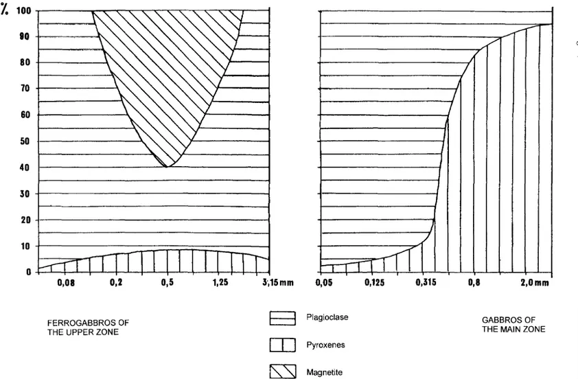
(12) CAD. LAB. XEOL. LAXE 22 (1997). 220 Lageat, Y.. REGIONAL MORPHOLOGICAL CONTRASTS. hydrolysis offragments of these rocks using distilled water have shown that clinopyroxenes decompose more rapidly than do feldspars, a feature which is confirmed by the respective ratios of these minerals in sand fractions in the field (fig. 4). The release ofmagnesium and calcium is favoured by a higher hydrogen ion concentrations in the solutions so that waters in contaet with magnetite-bearing rocks, like the ferrograbbros and ferrodiorites, are more acid than those in contact with other rock types. The sulphur content ofthe rocks enhances their rapid breakdown.Sulphur is released during the oxidation of sulphides in the Upper Zone. This causes decrease in pH which in turn enhances the alteration of the iron rich ferromagnesian minerals, as shown by the chemical analysis of water samples (all units mg/l except pH):. Overall the landscape of the eastern part of the Complex is characterised by the rejuvenation of an initial surface, the «Highveld Surface», the remnants ofwhich are well preserved on resistant acid roof rocks (felsites and granophyres). The structural relief of the region, with its a distinct scarp-and-vale morphology, has been developed during two subsequent stages offluvial incision and lateral planation. By contrast, despite a seemingly shared geological structure, the western region of the Bushveld Complex is a region of low relief known as the the «Bushveld Basin» which lies between 1,000 and 1,200 m. This planation surface is only punctuated by residuals belonging ro the Main Zone of the mafic sequence. There is only ane. Main Zone (8 samples) pH at 25° C. 7,98. Upper Zane (8 samples) 7,74. Ca. 32,3. 58,4. MG. 20,5. 28,3. Na. 10,0. 18,4. K. <1,0. <1,0. CI. 5,1. 17,4. S04. 7,5. 48,3. 159,0. 191,0. Total alkalinity as.
(13) CAD. LAB. XEOL. LAXE 22 (1997). 13. ;z. 12. ~ l/(. 11. Geomorphology 01 the Bushveld Complex. 221. ~. 10. 9 8. l/{l/{l/: l/<l/<l/:. IXIXIX. 7. v: ~. 6 5 4. ~. 3. l/:. 2. 1. 14. 13. 12. 11. 9. V:. v:. v:. l/{ 10. l/:. 8. 7. 6. l% v:. v:. ~. 5. 4. 3. Fig.3. Weathering scale ofbasic and ultrabasic rocks. 1- Marginal norite. 2- Feldspathic bronzitite. 3- Bronzitite (1.Z. and C.Z.). 4- Dunite (1.Z. and C.Z.). 5- Harzburgite (1.Z. and C.Z.). 6- Anorthosite (C.Z.). 7- Spottednorite. 8- Motded anorthrosite. 9- Gabbro (Mza). 10- Gabbro (Mzb). ll-Gabbro (Mzc). 12. Magnetite gabbro and diarite (V.Z.). 13. Magnetitite (V.Z.). 14- Troctolite (V.Z.).. J 2.
(14) "lo 100. ...--.--r--. 80. ,/. N N N. f. ..... ,. 80. ~. / I. 70. I. &0. /. I. I. 50 40 30 20. J. /. 10 II. O 0,08. 0,2. 0,5. 1,25. 3',15 mm. 0,05. I. T. 111. 0,125. 0,315. 0,8. 2,Omm. n. :>. IJ. ¡;:. FERROGABBROS OF THE UPPER lONE. E:3. Plagioclase. [TI. Pyroxenes. lJj. GABBROS OF THE MAIN lONE. @. ,.. O. ¡;: @. rs:sJ. Magnetite. Fig. 4. Mean eomposition of the sandy fraetion of regoliths.. N N. -. 'D 'D. ;:;'.
(15) CAD. LAB. XEOL. LAXE 22 (1997). Geomorphology o/the Bushveld Complex. 223. 1 133 .... 1255 ,. , \. ... 1232. \. 1. 127': •. 20km. I. .§6. -0-7. --8. -A. 1 O. Fig. 5. Geomorphological sketch of the Rustenburg area (Southwestern Bushveld). 1- Acid toof rocks. 2- Granitic cuesta. 3- Basic and ultrabasic rocks. 4- Main Magnerite Seam. 5- Main Zone gabbtoic residuals. 6- Syenitic dykes. 7- Merensky Reef. 8- lower conract of the layered suite. 9- Sedimenrs of the Pretoria Group. 10- Quartzite homoclinallandforms..
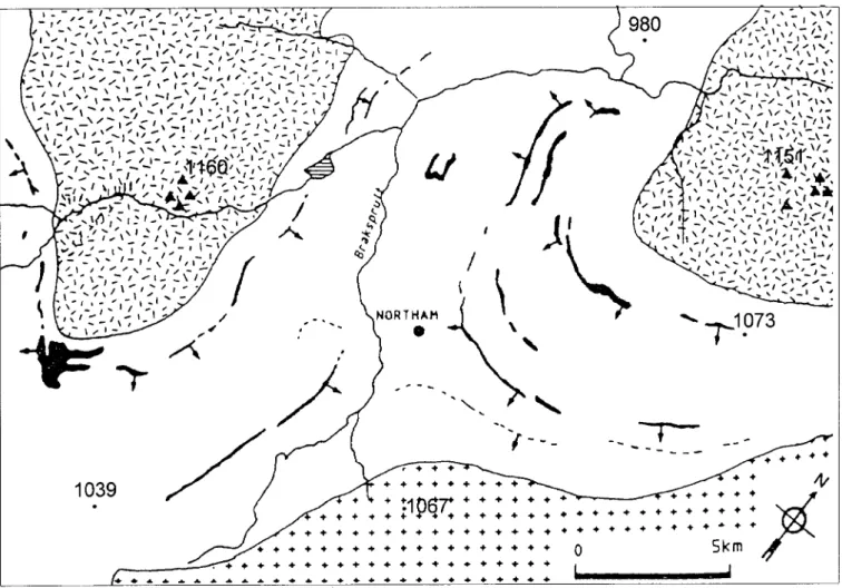
(16) :/. _.... 1\. _. -,':". ...:,J'_-;. ' __. ;\/. .,1/1. "_, . . ,1'"... . , .... -. .... ' ' ' ' -. '. l_-j,."""'/ I. .-..~. ': . . ~::.' ~:. -,-, -:-.. . -; \-;. ;-~' :-<' ~ ---;- .:,~ ~ ~/ .... _ _ 1 -... :: •. \. .: \. ,.'. _, _ \. 1. l' \ -. ,_ ,/, I -. _. .... I. \. _. ,. I. \. 1 l' I -. \_ -. , -. 1 .... 1 ..... - \. , .... , -;. , " .• ; l ' .... ' ,. _1 _, -;. \. , ....... 1. ~. I. _, -. -,. .. /' ,_'-;-'. ....._ /_1-_. " _.... _ I - I. L...-. ... , - ... \ ". I. '. J. -. .,.. ,'1,1 _>_, ' ,.. ~:'. ... .... ,() " ::: I :. I. '" ". 4!(:.. \. -. -. \-1 . / .... . . '" ,-;, " ' ' 'U-,. J ,-. \ -I.....I ~I. " -. _\-. """.,,/-:-~'" 1 ... - ' -, \-\ __ ,,1-,,1"', _1. '-' ... ~:. "'-',',;' ,..., ~'': ~ 1__ \/.. ,1,,,'~. \ -. ..... 1 \ 1 \. ,. ~I. -f?-" \ ... I. ..... ,. -. ... ..... I -,',. 1'" I. '--. -. -;-. l' ,-'.: _. -. 1. 1 ~. ,. t.I. 1~ '. -. _ ... ". \. ,. , , - / _. ,'-. I. , ....._,. -. ~. :<. '- _ 1. \'. \. " ' , ..... \ :-',-,: ,. \ ...... I. ....... ;. '..... _\. "'''\-\''_J~, \.. ..... '_1. ". " -rJ~73. .. ''¡ - --. -,-. .. .. ... ------ - + +. 1039. I~";.\ .... /~. -t7_'/\~,"""''''''~\_ -. ... ...... ~. I. "'". t-< ~ ~ ,'". , . '~ - , , , 'J-'~"'..... ' \ l' '/,_'_'''1', .. ""-'1 ,'" .... ,,,\,, .... '''_\~ , . . , '-J'".',-,. ' . ..:.,.. ._\',-'''-~_,. /. Á. ~t. ",. \. /. ... \ .. ....."/ ,l'"\~\,\'";~~, ......._ \"J 1'1 ~'~ .... , '_T' - '..'f l'\ "I_:"\,,\... ).:~ '-'\ . . -'1f. i. ~. \ ' ..... 1_' ". -,". ~\,'" ... -. -'\111\. I. (. ~ ....,. 1/ ' _. N N. " '::" ':., ': _\ -, - \-. , '-, ,_..,. {Sc1'''-". ,,'. +t;lfl' \ - " . . / - -.!!" '¡;,')'..,-\I \. ..... \ I 1 ' - '. \. \. ,. '1. ,. -1. ,"",-1'" - \ \:'\ ... , '1 " ... ..... ,-, ..... , ..... ,,... .... ~\-,\'. -, '. _,,1 \ \ I'/~;-''''~'. ~. .... I \. ,. , .... 1-::' -' -. >I, .../~ ,\ ...~ ,':,,-. 1. 1\. ....' 1 _ ' , \ _1 \_. /. _,"\-"", . . ,..,1 •-,. 1,,,1"'1' ,-\ ... , ...... -,_" -_ ,_ .... \', -, -..... ,-, ,-, .... " \ / ' \ - ... , \I-,.\I'\/-J',~_';I. I_I_:'~I:I, , - -,. ,,- , - / - ¡ .... \ _... , - ,\_'" 1... ',_, .... , . " . . ::'-'-,,-_1. ,,\/. " ,¿',' .. ,'~;\ ..... ti. ,\_\_,._~,,:_1-~_·1,.. ,. _. ~ ~. l:Jj. r,.;. ,. ... .. + + ~. ~. ~. ~ tT1 N. N. 1- Upper Zone and magnetite layers. 2- Main Zone. 3- Acid roof rocks. 4- Gabbroic inselbergs. Fig. 6. Geomorphological sketch of the Northam area (Northwestern Buskveld).. 'oD 'oD. ;::;!.
(17) (). > ENE. wsw. A. :~¡~¡~~ ¡!,!~!~j. "'Og :~1R 5. 10. 1,. ~ 20. 25. 50. 75. 100. sw. B. e. .,. ~. 120. § N N ~. \D \D. .::J. .':.:f:~~~i~~~~~~~~~~~~~·:·::: · . . ·.~i1j~:\fmJ~lliill§lli§ÜD;,:;~~:::»»<»)j NW. D. ~. ~ tJj. ':::i:::;:;:;:;:;:::;::::8"...... '. . 0G.• ,•~~@¡¡m¡llliM@,:;{.~'.;i;~»><. SE. r. '" ~. ""......'". ~ <..,;. l-7;-;:¡,. ~~. ~2. ~. ~,. ~4. ~. fITill. 5. EIJ. 6. ~. ~ tl::I. 1- Archaean basemenl. 2- Transvaal Supergroup 3- Lower and Critical Zones. 4- Main Zone 5- Upper Zone. 6- Roof rocks ( I = Highveld surface). ~ ;;:: ~. Fig.7. Generalized sections across the Bushveld Complexo A. & B. Eastern Bushveld. C. South-western Bushveld. D. North-wester Bushveld.. (j. '" ~. lf t0 t0. V\.
(18) 226 Lageat, Y.. exception, the prominent Pilanesberg Complex, an inselgebirge developed on a ring-complex mass of alkaline and hyperalkaline rocks, which is exposed as a result of the stripping of the Waterberg Sandsrones into which the crystallines were originally intruded sorne 1,300 M.y. ago. EIsewere the expression of differential erosion is quite discreteo Thus, in the southwestern sector the only manifestation of structural control in the landscape is associated with gabbros belonging to the central portion of the Main Zone : these outcrops occur as ridges (known as the "Pyramids") in a depression which has been excavated below the level of a culminant surface preserved on the roofofthe intrusion (fig. 5). On the other hand, in the northwestern sector, the acid roof rocks and basic intrusives are truncated by the same planation surface, with just a few gabbroic inselbergs standing aboye the generallevel of the high plain, the «Bushveld Surface», which merges westwards with the depositional surface of the Kalahari Basin (fig. 6). Ir is suggested that this contrast is due to recent tectonic events that have affected the rims ofthe «Bushveld BasiD». The southern rim, which is also the divide between the Orange and Limpopo drainage systems, coincides with an asymmetrical updoming, whereas the northern rim is affected by vertical displacements associated with a major fault system known as the «Palala Shear Zone». As the eastern rim corresponds to a steepening of a marginal swell, this implies that this «basiD» was produced by a «sagging process». This hypothesis has been thoroughly discussed by A L. DU TOIT (1933) and given more recent backing byT. STRATTEN (1979) and J.)' MAYER. CAD. LAB. XEOL. LAXE 22 (1997). (1985) who demonstrated that sorne of the diamondiferous alluvial gravels in the Lichtenburg area in the southwestern Transvaal at an altitude of 1,500 m derived from a northern source region which now lies more than 400 m lower down. Any analysis of the morphological evolution of the Bushveld Complex should involve a consideration of the epeirogenic deformations which have affected, albeit unequally, the whole region. These are apparent in the contrasted morphological expression ofspecific stratigraphic horizons. For example, the central part of the Main Zone forms the backbone of a prominent mountain chain in the eastern Transvaal, the Leoloberge which culminates over 1,900 m, the "Pyramids" north of Pretoria at an altitude of 1,400 m, and a few inselbergs in the northwestern Transvaal under 1,100 m. The Main Zone does not find any pronounced surface expression in the western Bushveld basin because of persisting subsidence and constant regradation ofthe initial Highveld surface which has been asymmetrically deformed. On the other hand upwarping of the eastern margin has led to repeated phases of differential erosion through polycyclical development with a marked structural imprint of the two latter planation cYcles (fig. 7). The planation surfaces of the eastern Bushveld are readily correlated with those recorded along the Great Escarpment of the Transvaal. Together with the intervening scarps they form a stepped sequence thought ro be due to pauses in the uplift of the marginal swell. lf we accept the traditional denudationmodel established by L.e. KING (1972): African, post-African l, and postAfrican II cycles, uncertainties remain concerning the chronology of this.
(19)
Figure


+2
Documento similar
MD simulations in this and previous work has allowed us to propose a relation between the nature of the interactions at the interface and the observed properties of nanofluids:
If the concept of the first digital divide was particularly linked to access to Internet, and the second digital divide to the operational capacity of the ICT‟s, the
In the “big picture” perspective of the recent years that we have described in Brazil, Spain, Portugal and Puerto Rico there are some similarities and important differences,
1. S., III, 52, 1-3: Examinadas estas cosas por nosotros, sería apropiado a los lugares antes citados tratar lo contado en la historia sobre las Amazonas que había antiguamente
Since such powers frequently exist outside the institutional framework, and/or exercise their influence through channels exempt (or simply out of reach) from any political
In the previous sections we have shown how astronomical alignments and solar hierophanies – with a common interest in the solstices − were substantiated in the
While Russian nostalgia for the late-socialism of the Brezhnev era began only after the clear-cut rupture of 1991, nostalgia for the 1970s seems to have emerged in Algeria
In summary, from the cluster analysis of individual bright knots and from the integrated photometry of the whole complex, there are clear indications that there is a complex
