Chapter 8: Computational intelligence for simulating a
LiDAR sensor
Cyber-Physical and Internet of Things automotive applications
Fernando Castaño1, Gerardo Beruvides2, Alberto Villalonga3 and Rodolfo E. Haber1
1 Centre for Automation and Robotics (CSIC - UPM), Ctra. Campo Real km. 0.200, Arganda del Rey, 28500, Spain
2 Automotive and Industry Lab, Hitachi Europe GmbH, Schwaig-Oberding, Germany
3 Technical University of Madrid, UPM; José Gutiérrez Abascal 2, Madrid, 28006, Spain
Abstract
In this chapter, an overview of some of the most commonly Computational Intelligence techniques used to provide new capabilities to sensor networks in Cyber-Physical and Internet-of-Things environments, and for verifying and evaluating the reliability issues of sensor networks is presented. Nowadays, on-chip Light Detection and Ranging (LiDAR) concept has driven a great technological challenge into sensor networks application for Cyber-Physical and Internet-of-Things systems. Therefore, the modelling and simulation of a LiDAR sensor networks is also included in this chapter that is structured as follows. First, a brief description of the theoretical modelling of the mathematical principle of operation is outlined. Subsequently, a review of the state-of-art of Computational Intelligence techniques in sensor system simulations is explained. Likewise, a use case of applying computational intelligence techniques to LiDAR sensor networks in a Cyber-Physical System environment is presented. In this use case, a model library with four specific Artificial Intelligence-based methods is also designed based on sensory information database provided by the LiDAR simulation. Some of them are multi-layer perceptron neural network, a self-organization map, a support vector machine and a k-nearest neighbours. The results demonstrate the suitability of using Computational Intelligence methods to increase the reliability of sensor networks when addressing the key challenges of safety and security in automotive applications.
8.1. Introduction
and infrastructures are presented in (Gölzer et al. 2015). The concept to achieve greater storage for historic data to predict future trends is plausible, however new sensory data processing and decision-making technologies are required (Yuan et al. 2015). The computational requirements in relation to operating systems, programming languages, user interfaces, and networking technologies have become more sophisticated in relation to software managing, information flow control, error control, redundancy, reliability and latency in heterogeneous global networks (Watteyne et al. 2016). Furthermore, the knowledge acquisition, the learning (Wan et al. 2014) and its transformation into physical actions to help machines in decision-making activities (Ruan et al. 2015) are priorities in the paradigm of CPSs.
Another important issue is the increase of computing power and wireless communication capabilities to expand the role of sensors from mere data collection to more demanding tasks that include sensor fusion, classification, and collaborative target tracking, that is, the inclusion of the concept of IoT sensor systems. Therefore, one of the main application fields for sensory systems and CPSs is the realistic scenarios for advanced driver-assistance systems (ADAS) and autonomous vehicles (AV) (Iovine et al. 2017; Zhao et al. 2017; Reiser et al. 2016). According to the Accenture LLP report, for the next ten years and beyond, the key areas into the automotive vehicle industry are: (i) cyber security; (ii) product liability for sensors and software and/or algorithms and (iii) insuring AV infrastructure (Rapberger 2017).
One particular challenge of autonomous driving is the accuracy and reliability estimation in vision devices such as Light Detection and Ranging (LiDAR) sensors and stereo cameras integrated in automotive driving assistance systems for pattern recognition and obstacle detection tasks (Vivacqua et al. 2017; Sim et al. 2016; Pandey et al. 2015; Chen et al. 2015). In many scenarios, it is very difficult to certify the real topology and distance of the objects at a lower level of uncertainty, in most cases due to dead zones, object transparency, light reflection, weather conditions, and sensors failures, among others [4]. Furthermore, traditional networking devices are not designed for use in unpredictable, variable, and dynamic environments that characterize an IoT transportation ecosystem, making it necessary to develop new methodologies that characterize and estimate sensor reliability (Ahmad 2014). Sensor fusion is commonly applied to combine different sensors for road detection, mainly cameras and LiDARs. Current sensor fusion methods are even taking advantage of both types of sensors (cameras or LiDARs), rather than exploiting the advantages of each individual type of sensor (Xiao et al. 2018b). Furthermore, the parallel processing of frames (from a camera) and (LiDAR) scans implies a high computational cost and is unnecessary in many scenarios where a sensor-based error-prediction model for assessing runtime reliability is operative (Zeng et al. 2018).
Several reconstruction methods are reported in the literature to create specific geometric models of existing objects from scanned point clouds based on information obtained from LiDARs (Hu et al. 2017). Progress with modelling techniques that simulate complex driving environments has led to realistic representations of multiple input/output variables, which have been used to determine the most influential factors in degraded reliability and to detect pedestrians, obstacles, and vehicles in real-time driving scenarios (Castaño et al. 2017a). Nowadays, many classifiers rely on machine-learning approaches to exploit data redundancy and abundance to finding out patterns, trends and relations amongst the input attributes and the class labels (Kala 2016). Within obstacle recognition techniques, vector support machines have been widely applied for classification and regression problems (Taghavifar et al. 2015; Apatean et al. 2013). An interesting application using machine learning for the pedestrian detection in autonomous vehicles based on HD 3D LiDAR is reported in (Navarro et al. 2016), providing more accurate data to be successfully used in any kind of lighting conditions. Clustering techniques are also intensively used in exploratory data mining, statistical analysis, pattern recognition, image analysis, information retrieval, bioinformatics, data compression, and computer graphics (Shi et al. 2018; Zhang et al. 2017).
The main objective to simulate sensors is related to fault tolerance and reliability that perform a key role for embedded systems, such as obscured wireless sensors that are deployed in applications where physical access is difficult (Bein et al. 2005). Throughout, this chapter will be described the basis of LiDAR sensor networks modelling and simulation techniques for CPS and IoT applications. Furthermore, the most commonly Computational Intelligence techniques reported in the literature for this purpose are described, doting of new real-time analytic and decision-making capabilities to the next sensor generations. Finally, a CPS use case is introduced in order to deploy a technical application scenario.
probabilities of both the sensors and the intermediate nodes (nodes used to relay messages between data sources, and data sinks) (AboElFotoh et al. 2005).
One way to carry out these simulations is using a co-simulation framework that takes into account physical dynamics, control software, computational platforms, and communication networks, which is crucial for designing CPSs for autonomous driving (Zhang et al. 2014; Artuñedo et al. 2015). Co-simulation is essential for CPSs due to virtual prototyping, capable of properly emulate actor-sensor nodes with their own hardware specifications (Ferracuti et al. 2016). Moreover, virtual prototyping can take advantage of different modelling languages/tools and integrate them together for evaluating the behaviour of CPSs. For example, processing elements with real-time operating systems (de Souza et al. 2014), communication systems, sensors, actuators, model transformations to the final virtual prototype (Mozumdar et al. 2014) and localization error estimation and compensation (Lee et al. 2015a) can be efficiently represented and modelled.
The current chapter is organized as follows. First, a brief description of the theoretical modelling of a LiDAR sensor based on the mathematical principle of operation will be described. After that, a review of the state-of-art of Computational Intelligence applications for sensor system simulations is presented. Three main issues are considered: the application of artificial intelligence techniques in IoT sensor networks, computational intelligence methods applied for pattern recognition and vision classification sensor-based analytics and computational intelligence procedures for localization optimization and energy consumption in sensor networks. Next, a real case study of artificial intelligence techniques applied to sensor networks in a cyber-physical system is presented. Finally, the conclusions and future research steps are summarized.
8.2. Theoretical modelling of a LiDAR sensor
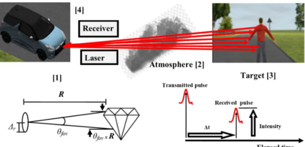
LiDAR, also frequently referred to as Laser Detection and Ranging (LiDAR), uses a laser to produce light pulses. LiDAR maintains some similitudes with its predecessor, Radio Detection and Ranging (RADAR), with the main deference being that it is carried out with electromagnetic radiation at a much smaller wavelength and greater frequency. Both technologies are based on time of flight (ToF) for the light pulses. In addition, light velocity allows these sensors to take numerous measurements per second (Al-Temeemy 2017).
Fig 8.1. The division of the process during simulation. Figure adapted from (Carlsson et al. 2001; Richmond and Cain 2010; Al-Temeemy 2017).
In the subsequent sections, mathematical models are carried out, considering automotive application’s constraints.
8.2.1. Laser beam model
The intensity of the laser beam across the range is not uniform, but varies in the spatial and temporal domains (Kim et al. 2013). It is defined as a beam profile and depends on the shape of the emitter and the technique used to generate the laser light. Generally, this profile or energy distribution is modelled as a spatial Gaussian function of radius r from the centre of the beam spot and distance z from the aperture (Al-Temeemy 2017):
2 2
2 2
( ) 0
0
( , )
( )
r z
I r z I e
z
(1)
where ω0 = λ / (π Θ) is the beam width (radius) of the pulse at z = 0 also known as the beam waist (Svelto and Hanna 1998).
The radial distance (in metres) at which the profile value is decreased to 1/e2 from its peak value is zr =
π ω0 / λ, where λ is the laser wavelength.
The value of I0 is found by integrating (1) over r and setting the result equal to the laser power, P.
0 2
0
2 P I
(2)
In addition, equation (3) represents the free space propagation of the beam results in divergence of the beam width, ω(z), where z is the propagation distance. This is true for distances that are less than the Rayleigh length (Svelto and Hanna 1998).
2
0
( ) 1
r
z z
z
(3)
2
( )
,
t
t
p t
e
where1/2
,
3.5
T
(4)
and T1/2 is FWHM (Full Width at Half Maximum), a standard measure of the pulse width. This pulse is a normal pulse used in laser radars, and by controlling T1/2, different properties of the pulse can be discovered.
8.2.2. Returned energy calculation
The original radar equations can be transformed into a laser radar equation as follows (Carlsson et al. 2001): 2 2 1 4 r
r t atm sys
S A P P R (5)
Assuming that, for an extended target, the footprint of the beam is smaller than the target surface, the returned power can be calculated using the transmitted power Pt, the travel distance of the laser beam R, the reflectance of the target surface ρ, and the aperture diameter of the receiver Ar, as represented in equation (5).
2
_ _
atm Tatm trancemitted Tatm trancemitted T atm
(6)
Equation (6) represents the round trip laser pulse, ηatm, as the square of the atmospheric attenuation. In addition, ηsys (inefficiencies and disturbances caused by the receiver system) is the product of the band pass filter transmittance, TBF, the fill factor, TFF, the ND (Neutral Density) filter transmittance TND, transmitter optics transmittance, TT, and receiver optics transmittance, TR.
sys TBPF TND TFF T TT R
(7)From the equations above, the received signal power at the receiver aperture Prcan be calculated using modified LADAR range equation:
2 2
2
4
t r atm BPF ND FF T R r
P A T T T T T T P
R
(8)
8.2.3. Noise Energy Calculation
The problems derived from some sources of noise can be divided into four separate parts and they are all simulated individually. First, energy loose and signal fade are directly related to the aerial attenuation. Second, we have the beam broadening, which makes the beam width increase with increased ranges, in addition to the beam divergence broadening. Thirdly, we have the scintillation, which makes the energy intensity fluctuate randomly across the beam area (Ove and Tomas 2001). Last, reflected sunlight and dark count are possibly one of the main sources of noise. Therefore, in order to simplify the mathematical LiDAR model, the incident energy of the backscattered solar radiation (see equation (9)) is the unique noise modelled in this chapter.
2 2
1 4
solar
si t atm sys
s
D
E E A
R
where Esi is the solar irradiance; δλis the electromagnetic bandwidth in of the bandpass filter; δt is the unit sampled time bin (the temporal resolution) of the system clock that measures the time; and is the area covered within the IFOV (instantaneous field of view) calculated in equation (10).
2
( )
A R IFOV (10)
_
atm Tatm received Tatm
(11)On the one hand, substituting equation (10) and (11) into (9), the incident energy of the backscattered solar radiation can be calculated by:
2 2
4
solar Esi t IFOV D Tatm TBPF TND TFF TR
E
(12)On the other hand, equation (13) represents the expected number of photoelectrons created by the dark count due to the thermal effects within the detector,
[ dc]
dc t
E N f
(13)where fdc is the dark count rate which is uniformly distributed in the time domain and every pixel in the detector has the same dark count (Kim et al. 2013).
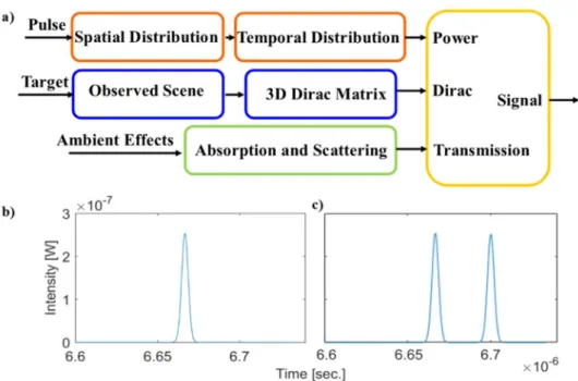
8.2.5. Single LiDAR model implementation
From the mathematical formulation of the radiometric aspect of LiDAR, the next step is the implementation of a LiDAR model and its simulation, assuming the most simplified use case, that is, a single laser and a single array of photodetectors without scanning. The single LiDAR model is composed by different submodules.
On the one hand, the spatial and temporal distribution of the laser should be considered. The variable ‘Pulse’ is the amount of energy contained in the laser pulse. The laser pulse energy is spatially distributed by equation (1) and the beam width is given by equation (3). The spatial limits of the plane that is normal to the propagation direction were defined to be three standard deviations of the Gaussian beam. The result of the spatial distribution is a 2D array that is passed to a function that temporally distributes the power according to equation (5).
On the other hand, the creation of a Dirac known as the target profile. This requires a command that describes the type of scene. The scene generator creates a 2D array that contains the range of every sample in the observed scene. A 3D Dirac matrix is then created from the 2D scene array with a length that corresponds to the TOF limits specified by the range gate. This is commonly known as the target profile.
Finally, the range equation can be applied. The final distribution of energy is calculated by convolving the distributed laser power with the target profile. The resulting 3D matrix represents all the spatial and temporal distributions in the calculation. A for-loop is then used to visit each array in the range gate to calculate the received power at the detector for each moment in time according to equation (8).
Fig. 8.2. a) A block diagram showing the structure of the single LiDAR model. Signal received in the detection of one target (b) and (c) two targets.
8.3. Computational Intelligence applications in Sensor System simulations
8.3.1. Application of artificial intelligence techniques in IoT sensor networks
IoT sensor networks require the integration of relevant stages such as: identifying, sensing, networking, and computation. These networks enable large-scale of technological innovations and value-added services which personalize user’s interaction. There are numerous IoT applications that can be grouped into various domains such as health, traffic, logistics, retail, agriculture, smart cities, smart metering, remote monitoring, process automation, among others. Despite the enormous progress in different research fields including architectures, standardization, emerging technologies, security, etc. (Čolaković and Hadžialić 2018). Wireless Sensors Networks (WSN) can be used to measure and track of energy consumption and production in order to optimize energy usage. In general, IoT communication is performed by producing and consuming information and by executing smart algorithms to interact intelligently with other things. The main challenges in the implementation of WSN in IoT are:
Deployment; Quality of Service; Localization; Energy consumption;
Data Collection and Transmission; Mobility management.
In order to deal with some these challenges, new communications protocols and tools are reported in literature, highlighting the use of artificial intelligence techniques (Gajate et al. 2009) in particular machine learning algorithms (ML) to solve complex situation in sensor network scenarios. Artificial Intelligence (AI) techniques provide to WSNs cognitive abilities in order to improve its performance by reducing power consumption, increasing network life-time, reliability, and also in general enhancing quality of service (QoS) through the processing of great amount of data obtained monitoring from the environment and applying optimization in order to determine the best parameters (Gheisari and Meybodi 2017).
data, may increase the network traffic and wastes the battery and power. Several techniques can be used such as nearest neighbour methods, and other clustering techniques for providing the system capabilities of self-adjust and data lost detection and correction (Zhang et al. 2018). Constructing real-time prediction models are important to maximize the network lifetime meanwhile guaranteeing connectivity and robustness (Hao et al. 2018). The design of adaptive and intelligent WSN is essential. The adaptation and self-organization capabilities can be introduced through embedding artificial neural networks in the control systems of the WSNs providing reliability (Serpen et al. 2013).
Sensor reliability is one of the main challenges found in IoT applications due to the need to ensure the correct monitoring of the process in order to ensure that the operation is within limits imposed. Since the sensor output is the only objective source of information of the status of the environment for decision making, it is essential that the operating status of the sensors be known. The performance of online monitoring and self-correction of multiple sensor, through the application of some ML algorithms such as support vector machine (SVM) and ANNs, is very important to reduce maintenance costs, minimize the risk of using uncalibrated or faulty sensors, increase instrument reliability, and consequently increase equipment life (Nsabagwa et al. 2018; Chuan and Chen 2011).
The network dynamics is another very important aspect to take into consideration into the sensor networks and IoT infrastructures. The interaction between the elements of the network can be determined by the performance of the network and it is critical to ensure it correct function. The need to develop a scheduling strategy to ensure the coverage of the points in wireless sensor networks to determines the optimal sequence of states and increase the lifetime of the network while considering the resource scarcity and addresses the network dynamism is essential. Techniques such as Hidden Markov Model presents great performance in the scheduling design allowing the optimization of the lifetime without decrease the network performance (Chaturvedi and Daniel 2017).
Protocols are also an important aspect to consider in the design of robust WSNs. The correct design of protocols has a great influence in the energy consumption, data congestion and in general the performance of the system. As the limited power of the sensors is one of the main challenges energy save is vital to ensure a correct operation of the system. The design of protocols with low power approach along with the uses of ANNs facilitate local processing allowing faster responses as well as improve overall system efficiency and power saving (Lobachev et al. 2018). In order to detect congestion the uses of algorithms like SVM to predict the level of congestion of the system allows the accurate adjustment of data transmission rate in each wireless sensor node which leads to a balanced traffic (Gholipour et al. 2017).
8.3.2. Computational intelligence applied in pattern recognition and vision
classification sensor-based analytics.
Nowadays, several challenges arise from the sensor fusion, real-time and on-board implementation on sensors networks motivated by the need of new functionalities such as: data pre-processing, advanced analytics, pattern recognition and classification actions based on the collection of huge amount of data points become a problem to be considered for current and future sensor manufactures, provides and researchers (Mammadova et al. 2017; Pramanik et al. 2018).
derive confidence measures among different classifiers and reduce the complexity of recognition system (Pires et al. 2016). Information fusion in human activity recognition are necessitated by increase in sensor of different modalities (Gravina et al. 2017). Information fusion techniques are prevalent in both handcrafted features and automatic feature learning using deep learning algorithms (Xiao et al. 2018a).
Deep learning algorithms are applied on sensor data to extract discriminative and salient features and then flattened and pass to an inference engine to recognise activities classes (Nweke et al. 2018). In this field, recently applications focused on pedestrian retrieval via part-based gradation regularization in sensor networks was reported by (Liu et al. 2018). The solution combines the strengths of the local convolutional neural network (CNN) to extract the main features and the discriminative an identification embedding model to propose a novel part-based gradation regularization method to assign a pedestrian label for each horizontal part. The results describe in the approach not only validate the high accuracy to learn from the local featured based on CNN, they also demonstrate improves the generalization ability of the classification model to mitigates the risk of overfitting and increase the performance of pedestrian retrieval due to rational utilization of pedestrian labels. Nevertheless, other traditional machine learning classifiers such as: support vector machine (Qiao et al. 2005), k-nearest neighbours (Madarshahian and Caicedo 2015), multinomial regressions (Madarshahian and Caicedo 2015) and Hidden Markov Models (Niu et al. 2014) are still highly used in pattern recognition and data classification applications.
By the other hand, intelligent transport systems (ITS) are highly impact research topic in recent years. The possibility to provide innovative services relating to different modes of transport and traffic management and enabling various users to be better informed and make safer, more coordinated and ‘smarter’ use of transport networks is very promising. ITS aim to improve transportation safety, mobility, productivity and environmental performance for traffic planners and road users. With continuous urban road development and extensive construction of expressways, increasing interest is devoted to vehicle detection (Yang and Pun-Cheng 2018). Into this transformation, the new generation of sensors, the sensor fusion, sensor network and IoT-based solutions get an important role in function to collect real-time data from the billions of devices present in the smart mobility ecosystems (Shi et al. 2017).
On example of that is reported by (Li and Lv 2017), with the purpose to improve the real-time performance and accuracy of vehicle type recognition in complex traffic scenes. For a single vehicle, data collected from A and B nodes have a certain temporal and spatial correlation, and the signals can be enhanced and fused in the later analysis. Based on this estimation, the authors have developed a multiple sensors information fusion method, which consists of the following key components: data segmentation and filtering, vehicle feature matching and vehicle feature waveform fusion. Finally, the experimental results obtained by the proposed method describes a 95% accuracy for small vehicles (tourism) and 90% accuracy for large vehicles (buses) approximately, becoming a key issue to provide references for multiple sensor network design and traffic data collection. Other recently example is the novel technique presented by (Mahaleh and Mirroshandel 2018) to apply a harmony search evolutionary algorithm in real-time line detection vision based for a two wheeled robotic platform. The proposed vision-based algorithm is implemented to process the images captured from on-board camera allowed in a two-wheeled robot, follows the path via on-board microcontroller governing motors. The proposed system is able to detect and follow the path with 99% accuracy, regardless of image size and eliminates edge detection phase altogether. These are only two examples of the true potentialities of the computational intelligence-based solutions based on sensor data collection to extract main feature of complex dynamic environments, model the potential actions and risk and facilitate the decision-making process for human and vehicles. The near future will demand fast solution in unknown situations, becoming the sensor and computational intelligence fusion a key issue to be considered to develop more robust, efficient and safety human-machine ecosystems.
8.3.3. Computational intelligence applied in localization optimization and energy
consumption in sensor networks
Most WSNs reliability assessments are based on graph theory and probability theory. Connectivity reliability investigates the probability that the network is still connected for a given period of time under the case of some nodes or links failure. Performance reliability analyses the end-to-end delay, packet delivery rate, and other network parameters (Laranjeira and Rodrigues 2014; Yan et al. 2014).
WSNs reliability is influenced by many factors such as component failure, environmental influences, task changes, and network update. These factors and network behaviour are difficult to be described or calculated by mathematical models. Network simulation becomes an important method to analyse network reliability (Vo et al. 2015). Based on that, the objective of this subsection is to analyse computational intelligence-based implantations reported in the literature to contribute on the sensor networks reliability. Following, four main topics were selected based on node localization, energy management, network multi-objective optimization and self-capabilities approach to describe the impact of the computational intelligence techniques into the present and future sensor networks (Cacciagrano et al. 2019; Hossain et al. 2018).
The emergence IoT-based applications are revolutionizing the current concept of industry, transportation systems, energy grids, cities and society (Mukherjee et al. 2017). To archive this transformation, many daily applications based on IoT require an efficient nodes position, and localization mechanism (Kumar and Lobiyal 2017; Bradai et al. 2015). Localization technology has been a core component for Internet of Things, especially for Wireless Sensor Network.
On one hand, the localization techniques Range-Based are based on measuring of the distance or the angle between the directions of reference nodes called anchors. Several technologies allow the nodes distance measure such as: Received Signal Strength Indicator (Hightower and Borriello 2001), Time of Arrival (Pottie and Kaiser 2000), Time Difference of Arrival (Priyantha et al. 2000) and Angle of Arrival (Savvides et al. 2001), among others. By the other hand, range-free-based localization solutions can avoid the increase of the energy consumption and the inappropriate cost of the equipment. Range-free technologies introduce an independence between the hardware devices and the distance computing (Sheu et al. 2008). Hence, this independence allows the adaption technology of different wireless transmission types based on locations as centroid, Approximate Point in Triangle Test (He et al. 2003) and Distance Vector-Hop (DV-Hop) (He et al. 2003). Although these algorithms provide more economic and simple estimations, their results are not as accurate as tracking error level. A precise detection of the transmitter node position allows an effective routing of information with a minimum energy consumption. Another important parameter is the localization time which is the necessary time for the network localization (Tlili et al. 2014). Nevertheless, range-free algorithms have relatively lower localization accuracy, but it is more widespread to be used because of the inexpensive cost and simplicity, especially in the large-scale network (Khan et al. 2018).
In this topic, an interesting result are introduced by (Cui et al. 2018), developing a novel high accurate localization algorithm based on DV-Hop and differential evolution (DECHDV-Hop) for WSN. In particular, DECHDV-Hop improves the positioning accuracy without adding extra equipment to the sensor network. In order to further reduce the localization error, DE algorithm is used to locate unknown nodes by formulating the location estimation process as an optimization problem. The obtained results show a reduction in the average localization error about 70% compared with traditional DV-Hop techniques in the simulation of four different network situations (Random, Grid, shaped random and C-shaped grid). The average localization error was estimated based on the following equation:
(1 p) N
2 2
i i i i
1
(x x ) (y y )
(1 p) N
i
L
R
(14)
where (xi, yi) and (xi , yi) are the estimated location and actual location respectively; N is the sensor nodes count, p is the percentage of anchor nodes, and R is the communication range. In all cases, the smaller average localization error value, the higher the localization accuracy.
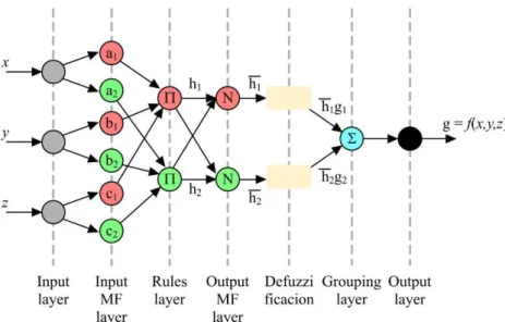
Fig. 8.3. ANFIS model representation based on the model proposed by (Gharghan et al. 2018).
The obtained results demonstrate the divergence between the ANFIS and theoretical models when the distance increased. A convergence between the theoretical and measured plots has been observed for the outdoor velodrome. On the contrary, there is a big divergence among the theoretical and measured plots for the indoor velodrome relative to the outdoor velodrome. This is because of the multipath effect, due to the presence of reflections, scatters and diffractions from indoor objects such as furniture, doors, windows, and walls in the sports hall. The results showed that the distance estimation accuracy was improved by 84% and 99% for indoor and outdoor velodromes, respectively, after applying the ANFIS optimization.
Multi-objective heuristic optimization algorithms become an important tool (Beruvides et al. 2016; Haber et al. 2017) to solve localization in wireless sensor networks, especially those without the aid of a Global Positioning System (GPS). Pareto-based solutions contribute to find the better performance in WSNs, considering several aspect or key issue to find the optimal balance for each particular situation. In this direction, a hybrid Multi-objective evolutionary algorithm Sensor Placement Optimizer (M-SPOT) is introduced by (Perez 2018), with the objectives to minimise the total number of devices deployed into the network and the total energy dissipated by the sensors (see Fig. 8.4).
Fig. 8.4. Problem instance where the blue points represent locations to be sensed for WSN nodes.
accuracy to be closer to the actual node locations in relation with the diversity of signal strengths. The results validate the performance proposed algorithm on irregular topology, is outstanding (as determined by the lowest location estimation error with a comparatively low complexity trade-off) compared to other soft-computing-based localization approaches.
Another particular application of the heuristic techniques is reported by (Xu et al. 2018). In a medical sensor network, the users’ information needs to be transmitted to the doctor workstation with smaller time delay. Meanwhile, the reliability and energy consumption are necessary to be considered. To archive this goal, the authors considered the smaller time delay, high reliability to transfer information, and prolong the lifetime of the node simultaneously as objective functions. For that, a differential evolution was selected to optimise the smaller delay time needs sensor network quickly process and transmit the data, as well as, to increase the reliability to reduce the probability of false or loss package. An interesting result introduced by this approach is relationship between the increase in the reliability and increase the delay and energy consumption, these have conflicts each other. Otherwise, prolonging the lifetime of the node needs to consider the energy consumption and residual energy, and then try to choose more residual energy of nodes involved in information transmission.
Most applications of WSN require that the sensor nodes must be aware of their location relative to the SN. For this, one of the important challenges in WSN is the localization of sensor nodes and determination of nodes positions in the sensor field (Singh et al. 2018). As it was commented before, in the case of sensor networks, the energy is other key performance indicator of efficient and reliability values. For this, GPS devices are not convenient as valid solution of localization problem in WSN for many reasons (Amri et al. 2017):
Once the expensive GPS devices are added to every sensor node in the network, this solution became unfeasible due to the increase of the deployment cost.
With the inclusion of GPS device, the sensor nodes size become quite large limiting the required properties of WSN that nodes should be with small size.
To be in function, GPS devices depend forever to satellites. In cases of failure with satellite link, GPS ceases to be in function. It is the case of many real applications as indoor and explorative applications.
Finally, GPS in WSN stays depend of many factors as power consumption, cost, size, what is not the case of other localization techniques.
In order to sustain long term sensing capability over a large coverage set, the energy conservation become an important factor to extend the battery life in sensor networks. Replacement of a node battery is infeasible due to the harsh environment in which the sensor networks are usually deployed in (Pantazis et al. 2013), becoming an imperative issue to prioritise energy efficiency in order to maximise network lifetime and performance. In time-critical applications, routing delay also becomes a pressing factor (Ramluckun and Bassoo 2018). In order to address the energy consumption issue effectively, the Energy-Efficient Grid-based Routing algorithm introduced by (Logambigai et al. 2018), overcoming the hotspot problem and utilizes the energy of nodes more efficiently. This algorithm consists of three different phases namely grid formation, grid coordinator election and grid-based routing phases. For that, each grid is elected by applying fuzzy logic where the fuzzy variables are used for grid coordination selection based on the residual energy of the nodes, their mobility pattern and the distance of the nodes from the sink node. As the transmission consumes energy based on the distance, the distance to the sink is considered as an important issue to select the grid coordinator, monitoring the energy utilization of the network continuously.
In terms of sensor networks energy consumption optimization topics, the clustering techniques take an important role. Several researchers have been introduced interesting contribution in field during the last years. One example of that, it is the energy aware routing for throughput optimization in clustered IoT-wireless sensor networks introduced by (Shah et al. 2018). The extensive devices connected through IoT bring forth many challenges such as high battery power consumption, designing for smart transportation, health and home control system devices, among others. To solve the above problems, an optimal clustering mechanism based on Fuzzy-C means clustering is designed to divide the sensor nodes into different clusters (Su and Zhao 2018). The results introduced in the approach demonstrate the potentialities of the clustering-based algorithms to optimize the energy consumption in WSNs.
One example of that are the contributions reported by (Elsayed et al. 2017), based on self-maintenance model for WSNs. The approach introduces a distributed self-healing approach for both node and cluster head levels, archiving a detection accuracy of sensor circuit fault tolerate up to 76.9%; 52% of battery fault and 71.96% of receiver faults. The pseudocode 1 describes the algorithm proposed by (Elsayed et al. 2017) for self-fault detection in sensors networks.
Begin
Nfault = [0]
Ncontroller = [0]
Nk = [0]
Sensor node transfer HBmsg to CH
IF HBmsg periodically sensed in CH:
Node is healthy CH checks its aggregated data
IF the aggregated data was closely:
Nk = Nk + N
ELSE:
Ncontroller = Ncontroller + N
ELSE:
Node is mal function: Nfault = Nfault + N
Isolate it and update the topology to replace this node Sensor node periodically transfer introduction message to CH
IF CH received sleeping notification from sensor node:
Remove this sensor and assign its function to posterior Select new path
ELSE:
Nk = Nk + N
End
Pseudocode 1. Fault detection algorithm at CH level extracted from (Elsayed et al. 2017).
where, N is the number of nodes, Nk is the active vertices of the network, CH is the cluster head and HBmsg is periodic heartbeat message.
In the same topic, this time focused on the self-configuration algorithm, an efficient neural network model to minimize the weakly connected dominating sets in WSNs is introduced by (He et al. 2009). The experimental results develop by the authors demonstrate that the proposed neural network with direct convergence achieves much better performance in the quality of solutions and efficiency. Furthermore, the results indicate the importance of the selection of a suitable transmission radius to make the network have a good stability and a long lifespan. As it can be appreciated along this section, the computational intelligence-based solutions have become a key issue to optimize localization, energy and accuracy in current and future sensor networks, improving higher levels of efficient, reliability and self-healing capacities.
8.4. Use Case: Sensor system application
As demonstrated in the previous section, computational intelligence can be used in a multitude of applications. In this chapter, as example, a use case will be presented, that are based on the methodologies described in (Castaño et al. 2017a) (Castaño et al. 2017b) and (Castaño et al. 2018). The CI methods will be applied in a 3D scenario simulation software, in which has been used the mathematical LiDAR model set in the before section. This simulation software is Webots R2018b for automobiles (Michel 2004).
8.4.1. LiDAR model simulation
A simulation procedure is the first step before applying the CI into a CPS or IoT scenario in order to create a training dataset with the information collected from the sensor network in order to integrate a conjunction of CI methods with the mathematical 4-layer LiDAR model (described in section 8.2.5). The aim of this first simulation is to get data acquired by the LiDAR model in the simulation tool to generate classification models based on CI methods. The classification models will be applied to the LiDAR sensors to be able to compare the results when recognizing obstacles.
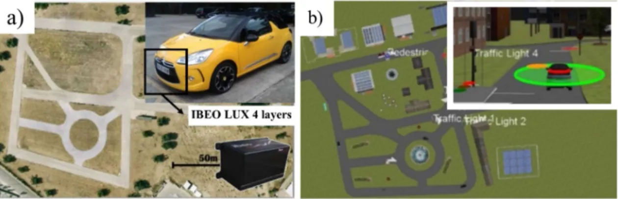
A virtual driving traffic scenario that emulates a real test track was generated in Webots. The virtual scenario emulates the real setup available in the Centre for Automation and Robotics (CAR-CSIC), Madrid, Spain1. This consists of a grid form, simulating city blocks, along with some additional elements:
a roundabout in one of the quadrants, traffic lights in the central crossing and additional curves on the main straight. Based on that an urban environment was achieved, with a broader set of curves, a small diagonal segment, every street has a minimum width of 6 meters, allowing traffic in both directions (see Fig. 8.5. (a)).
Although each vehicle has been equipped with different specific sensors and actuators, the control architecture is in essences the same for all of them. Its backbone is an On-Board Unit that handles sensor inputs, and a fuzzy logic controller that manages individual actions on throttle, brake, and steering wheel (Godoy et al. 2015). The last vehicle listed (Citroën DS3) is the one with a higher number of sensors: DGPS (20 Hz) receiver Trimble BD960, 3D Stereo vision camera Bumblebee X2 and a Lidar 4 layers Ibeo Lux.
Therefore, in order to emulate this real testing scenario, a virtual driving traffic scenario was created in Webots Automobile simulation tool based on the state-of-art of LiDAR sensor model. Fig. 8.5. (b) also illustrates the aerial view of some of these 3D scenarios in Webots for automobiles for driving assistance. The scenario for simulation was set up with three fully automated vehicles with the on-board sensors.
The next step once the scenario has been created is to simulate all the models configured in Webots, including the theoretical model of the LiDAR. Four hours of sensors data provided by the virtual sensors data were recorded. The data obtained from these sensors are camera images with objects recognized and the LiDAR point clouds. In total, a benchmark with 1031 scenes was available with the same number of LiDAR scans, captured images, and annotation files with the localization of each recognized obstacles.
Fig. 8.5. Aerial view of the (a) real and (b) 3D simulated scenario, with a real and modelled vehicle with sensors incorporated.
Subsequently, in order to facilitate the training of the classification models and determine the error prediction models, the raw data from the LiDAR sensors required filtering and pre-processing. For example, in this particular use case, the points that map the road asphalt at ground level and the vegetation were deleted. These points were mainly located at 20 cm above ground level.
The next data-processing step consisted of extracting the points by mapping nearby obstacles that correspond to a specific point-cloud sequence, using a clustering algorithm, and to compare each LiDAR calculated centroid with the actual location generated by the object recognition algorithm of each obstacle. Therefore, a training data set of 1031 samples was generated.
8.4.2 Cyber-physical application
The aim of this use case is the LiDAR model simulation implemented in the last section for obstacle detection in a transportation cyber-physical system. During the simulation, the library initially contains some classification models by default, and later, the content will be enriched in the runtime during the process simulation of the scenario. In this particular use case, three techniques are then considered, i.e., multi-layer perceptron neural network, self-organization map, support vector machine, k-nearest neighbour and naive Bayes. The main rationale for their selection is the solid mathematical foundations, demonstrated ability in modelling in complex scenarios and a wide range of successful applications.
The first technique was a multi-layer perceptron (MLP) neural network with an input layer with 18 neurons, a hidden layer of 40 neurons and an output layer with a single neuron and linear activation function (Alique et al. 2000; Fe et al. 2018; Haber and Alique 2004). For training, the method used was gradient descent with momentum and adaptive learning rate backpropagation. The initial values of learning rate, and performance goal were 10-7 and 10-8, respectively. The network was trained during
50,000 iterations, after which it reached a best performance of 0.0216 and a gradient of 0.0021. Using the validation set, values of mean square error (MSE) of 0.0409 and correctly classified instances (CCI) equal to 95.91% was reached.
The second method for the obstacle recognition library is a self-organizing maps (SOM) (Voumvoulakis and Hatziargyriou 2008). Specifically, a topology function that creates neurons in an N -dimensional random pattern was used, and the dimensions were 22 x 2. Finally, the Manhattan function was applied as distance function. In addition, an input weight equal to the number of observations in the training set was set, i.e. w = 1050. The network was trained during a cover step of 10000 and an initial neighbour size of 4, after which it reached a MSE of 0.132 and a CCI equal to 89.55% was reached using the validation set.
The third, a support vector machine (SVM) was also implemented in the library (Murty and Raghava 2016). This nonlinear classifier uses a Gaussian Kernel function with a kernel scale σ = 0.94 and a box constrain of 9.78e4. The supervised learning method was trained during 1255 iterations, until its reason
for convergence gradient reached a Δ < 0.001. The results obtained during validation were a MSE of 0.0636 and a CCI equal to 93.64%.
The fourth, selected technique was a k-Nearest-Neighbours (kNN) clustering algorithm. K-NN is one of the simplest non-parametric classification methods with an easily interpretable output, low calculation times, and high predictive power (Aziz et al. 2018; Khaldi et al. 2018; Beruvides et al. 2017; Penedo et al. 2012). The setting parameters used was a Euclidean distance and the number of neighbours equal to 5. The results obtained during validation step were a MSE of 0.1388 and a CCI equal to 86.82%.
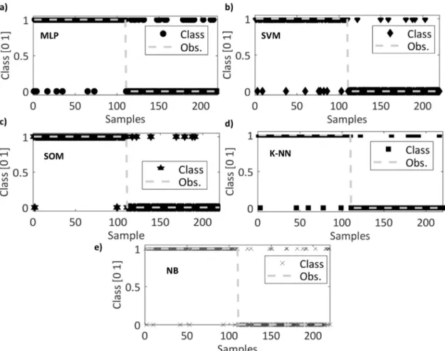
Fig. 8.6. Validation results in pedestrian detection (a) MLP, (b) SVM, (c) SOM, (d) k-NN and (e) NB.
Fig. 8.6 shows the classifiers outputs of the five models vs. observed classes using the validation set. The classifiers outputs indicate whether the detected object is a pedestrian (class 1) or not (class 0). MLP, followed very closely by SVM, has the smallest error and the highest number of correctly classify instances. Instead, SOM and k-NN have also obtained acceptable success rates but below 90%. Even the worst result that correspond to k-NN has very good performance indices. This study is not conclusive and therefore a validation with unknown data set is required using more performance indices to make a more complete comparative study among the five classifiers.
The current testing set in good weather climatological conditions (sunny) contains 230 segments (not known beforehand), and detailed annotations regarding the pedestrian appearances (in terms of occlusion), namely: occluded/partial pedestrians (class-0) and entire body pedestrians (class-1).
Table 8.1. Comparative study of MLP, SVM, SOM (Castaño et al. 2017a), Naive Bayes and k-NN (Castaño et al. 2017b).
Performance Index\Approach MLP SVM SOM Naive Bayes k-NN
CCI (%) 88.19 91.36 90.91 88.18 93.64
ICI (%) 11.81 8.64 9.09 11.82 6.36
MAE 0.12 0.09 0.09 0.11 0.0636
RMSE 0.34 0.29 0.30 0.33 0.25
RAE (%) 23.64 17.29 18.68 23.62 12.74
RRSE (%) 9.27 7.93 8.36 9.26 6.81
The application of the previously unknown test data set on the MLP classification model that obtained the best results in validation studies, yielded 23.64% of RAE. On the contrary, SVM and SOM achieved an excellent accuracy, for instances 17.29% and 18.68% in RAE, respectively, although not too much lower in percentage than the MLP error. The excellent behaviour is also endorsed with high correct classified instances of 93.64%, achieved by k-NN. The worst result occurred with NB, although it is the model that less varies its merit figures regardless of the input data set.
8.5. Conclusions
In this chapter, the modelling and simulation techniques for LiDAR sensor networks are presented. Highlighting, the most commonly Computational Intelligence techniques reported to add new functionalities and decision-making capabilities into LiDAR sensor networks for Cyber-Physical Systems and Internet-of-Things environments. Nowadays, the main objective to simulate the sensor behaviours is related with the ability to increase the fault prediction and reliability, defining as a key performance role far from the current physical testing operations. In addition, it was demonstrated that on-chip Light Detection and Ranging concept has driven a great technological challenge into sensor networks.
In this chapter, with the aim of a more exhaustive compression of the behaviour of a LiDAR sensor, a brief description of the theoretical modelling based on mathematical principles of operation is outlined. The mathematical modelling is focused on the radiometric aspect of single LiDAR, that is composed by different submodules, such as laser beam, returned energy and energy noise. As example, this sensor model is implemented, assuming the most simplified use case which is a single laser and a single array of photodetectors without scanning and will be used in the later simulation steps.
Subsequently, the chapter describes a general overview of state-of-art Computational Intelligence techniques commonly used in sensor system simulations applications. Some of these applications are AI-based techniques for CPS and IoT sensor network solutions, computational intelligence for pattern recognition and vision classification sensor-based analytics, localization optimization and energy consumption in WSN. In summary, the technical review draws the following key concluding remarks. Firstly, due the great advance of informatics and communication technologies, which has allowed the reborn of the AI-based solutions, the applications of machine learning algorithms in engineering have risen especially in fields of recent emergence such as CPS, CPSS and IoT. Furthermore, the WSN, considered one particular field into the IoT-based solutions, has also received a lot of attention on the application of ML algorithms, becoming one of the main tools to address the main challenges for implementation in industrial and services scenarios. Secondly, the near future will demand fast solution in unknown situations, becoming both the sensor and computational intelligence fusion key issues to develop more robust, efficient and safety human-machine ecosystems. Finally, the computational intelligence-based solutions have become a relevant to optimize localization, energy and accuracy in current and future sensor networks, improving higher levels of efficient, reliability and self-healing capacities.
In order to corroborate the potential of the computational intelligence for adding new capabilities to sensor networks in Cyber-Physical Systems and Internet-of-Things environments, a use case is presented. CI methods were applied to a 3D scenario simulation software (Webots) for automobiles, using the mathematical LiDAR model defined in this chapter. The application of a model library for object classification tasks, using the LiDAR data in a virtual sensor network for obstacle recognition actions in driving assistance in a cyber-physical system scenario showed very promising results. Dour Artificial Intelligence-based methods and a probabilistic method for obstacle recognition were applied: a multilayer perceptron, a self-organized map, a support vector machine, k-nearest neighbours and naive Bayesian network. The results demonstrated the suitability of applying Computational Intelligence methods to increase the reliability of sensor networks, addressing the key challenges to increase the safety and security in automotive applications.
Acknowledgments
References
AboElFotoh HMF, Iyengar SS, Chakrabarty K (2005) Computing reliability and message delay for Cooperative wireless distributed sensor networks subject to random failures. IEEE Transactions on Reliability 54 (1):145-155. doi:10.1109/TR.2004.842540
Ahmad M (2014) Reliability Models for the Internet of Things: A Paradigm Shift. Paper presented at the 2014 IEEE International Symposium on Software Reliability Engineering Workshops, 3-6 Nov. 2014
Al-Temeemy AA (2017) The Development of a 3D LADAR Simulator Based on a Fast Target Impulse Response Generation Approach. 3D Research 8 (3). doi:10.1007/s13319-017-0142-y
Alique A, Haber RE, Haber RH, Ros S, Gonzalez C Neural network-based model for the prediction of cutting force in milling process. A progress study on a real case. In: IEEE International Symposium on Intelligent Control - Proceedings, 2000. pp 121-125
Amri S, Khelifi F, Bradai A, Rachedi A, Kaddachi ML, Atri M (2017) A new fuzzy logic based node localization mechanism for Wireless Sensor Networks. Future Generation Computer Systems
Apatean A, Rogozan A, Bensrhair A (2013) Visible-infrared fusion schemes for road obstacle classification.
Transportation Research Part C: Emerging Technologies 35:180-192. doi:https://doi.org/10.1016/j.trc.2013.07.003
Artuñedo A, Godoy J, Haber R, Villagrá J, Toro RMd Advanced Co-simulation Framework for Cooperative Maneuvers Among Vehicles. In: 2015 IEEE 18th International Conference on Intelligent Transportation Systems, 15-18 Sept. 2015 2015. pp 1436-1441. doi:10.1109/ITSC.2015.235
Aziz S, Mohamed EA, Youssef F (2018) Traffic Sign Recognition Based On Multi-feature Fusion and ELM
Classifier. Procedia Computer Science 127:146-153. doi:https://doi.org/10.1016/j.procs.2018.01.109
Bein D, Jolly V, Kumar B, Latifi S (2005) Reliability modeling in wireless sensor networks. International Journal of Information Technology 11 (2):1-8
Beruvides G, Castaño F, Haber RE, Quiza R, Villalonga A (2017) Coping with Complexity When Predicting Surface Roughness in Milling Processes: Hybrid Incremental Model with Optimal Parametrization. Complexity 2017. doi:10.1155/2017/7317254
Beruvides G, Quiza R, Del Toro R, Haber RE (2013) Sensoring systems and signal analysis to monitor tool wear in microdrilling operations on a sintered tungsten-copper composite material. Sensors and Actuators, A: Physical 199:165-175. doi:10.1016/j.sna.2013.05.021
Beruvides G, Quiza R, Haber RE (2016) Multi-objective optimization based on an improved cross-entropy method. A case study of a micro-scale manufacturing process. Information Sciences 334-335:161-173. doi:10.1016/j.ins.2015.11.040
Bhave A, Krogh BH, Garlan D, Schmerl B View consistency in architectures for cyber-physical systems. In: Proceedings of the 2011 IEEE/ACM Second International Conference on Cyber-Physical Systems, 2011. IEEE Computer Society, pp 151-160
Bradai A, Benslimane A, Singh KD (2015) Dynamic anchor points selection for mobility management in Software Defined Networks. Journal of Network and Computer Applications 57:1-11
Bures T, Weyns D, Klein M, Haber RE 1st International Workshop on Software Engineering for Smart Cyber-Physical Systems (SEsCPS 2015). In: 2015 IEEE/ACM 37th IEEE International Conference on Software Engineering, 16-24 May 2015 2015. pp 1009-1010. doi:10.1109/ICSE.2015.326
Cacciagrano D, Culmone R, Micheletti M, Mostarda L (2019) Energy-Efficient Clustering for Wireless Sensor Devices in Internet of Things. In: Performability in Internet of Things. Springer, pp 59-80
Carlsson T, Steinvall O, Letalick D (2001) Signature simulation and signal analysis for 3-D laser radar. Sweden: Swedish Defence Research Agency:7-8
Castaño F, Beruvides G, Haber R, Artuñedo A (2017a) Obstacle Recognition Based on Machine Learning for On-Chip LiDAR Sensors in a Cyber-Physical System. Sensors 17 (9):2109
Castaño F, Beruvides G, Haber RE, Villalonga A (2017b) Time-To-Failure Modelling in On-Chip LiDAR Sensors for Automotive Applications. Proceedings 1 (8):809
Castaño F, Beruvides G, Villalonga A, Haber RE (2018) Self-tuning method for increased obstacle detection reliability based on internet of things LiDAR sensor models. Sensors (Switzerland) 18 (5). doi:10.3390/s18051508 Chaturvedi P, Daniel AK Hidden markov model based node status prediction technique for target coverage in wireless sensor networks. In: 2017 International Conference on Intelligent Communication and Computational Techniques (ICCT), 22-23 Dec. 2017 2017. pp 223-227. doi:10.1109/INTELCCT.2017.8324049
Chen C-I, Koseluk R, Buchanan C, Duerner A, Jeppesen B, Laux H (2015) Autonomous Aerial Refueling Ground Test Demonstration—A Sensor-in-the-Loop, Non-Tracking Method. Sensors 15 (5):10948-10972
Chuan Y, Chen L (2011) The Application of Support Vector Machine in the Hysteresis Modeling of Silicon Pressure Sensor. IEEE Sensors Journal 11 (9):2022-2026. doi:10.1109/JSEN.2011.2109706
Čolaković A, Hadžialić M (2018) Internet of Things (IoT): A review of enabling technologies, challenges, and open
research issues. Computer Networks 144:17-39. doi:https://doi.org/10.1016/j.comnet.2018.07.017
Cornacchia M, Ozcan K, Zheng Y, Velipasalar S (2017) A Survey on Activity Detection and Classification Using Wearable Sensors. IEEE Sensors Journal 17 (2):386-403. doi:10.1109/JSEN.2016.2628346
Cui L, Xu C, Li G, Ming Z, Feng Y, Lu N (2018) A high accurate localization algorithm with DV-Hop and differential evolution for wireless sensor network. Applied Soft Computing 68:39-52
Elsayed W, Elhoseny M, Sabbeh S, Riad A (2017) Self-maintenance model for wireless sensor networks. Computers & Electrical Engineering
Fe IL, Beruvides G, Quiza R, Haber R, Rivas M (2018) Automatic selection of optimal parameters based on simple soft computing methods. A case study on micro-milling processes. IEEE Transactions on Industrial Informatics PP (99):1-1. doi:10.1109/TII.2018.2816971
Ferracuti F, Freddi A, Monteriù A, Prist M (2016) An integrated simulation module for cyber-physical automation systems. Sensors 16 (5):645
Gajate A, Haber RE, Alique JR, Vega PI (2009) Transductive-weighted neuro-fuzzy inference system for tool wear prediction in a turning process. Lecture Notes in Computer Science (including subseries Lecture Notes in Artificial Intelligence and Lecture Notes in Bioinformatics), vol 5572 LNAI. doi:10.1007/978-3-642-02319-4_14 Gharghan SK, Nordin R, Jawad AM, Jawad HM, Ismail M (2018) Adaptive Neural Fuzzy Inference System for
Accurate Localization of Wireless Sensor Network in Outdoor and Indoor Cycling Applications. IEEE Access Gheisari S, Meybodi MR (2017) A new reasoning and learning model for Cognitive Wireless Sensor Networks based
on Bayesian networks and learning automata cooperation. Computer Networks 124:11-26. doi:https://doi.org/10.1016/j.comnet.2017.05.031
Gholipour M, Haghighat AT, Meybodi MR (2017) Hop‐by‐Hop Congestion Avoidance in wireless sensor networks
based on genetic support vector machine. Neurocomputing 223:63-76.
doi:https://doi.org/10.1016/j.neucom.2016.10.035
Godoy J, Pérez J, Onieva E, Villagrá J, Milanés V, Haber R (2015) A driverless vehicle demonstration on motorways and in urban environments. Transport 30 (3):253-263. doi:10.3846/16484142.2014.1003406
Gölzer P, Cato P, Amberg M Data Processing Requirements of Industry 4.0-Use Cases for Big Data Applications. In: ECIS, 2015.
Gravina R, Alinia P, Ghasemzadeh H, Fortino G (2017) Multi-sensor fusion in body sensor networks: State-of-the-art
and research challenges. Information Fusion 35:68-80. doi:https://doi.org/10.1016/j.inffus.2016.09.005
Haber-Guerra R, Liang SY, Alique JR, Haber-Haber R (2006) Fuzzy control of spindle torque in high-speed milling processes. Journal of Manufacturing Science and Engineering, Transactions of the ASME 128 (4):1014-1018. doi:10.1115/1.2194063
Haber RE, Alique JR (2004) Nonlinear internal model control using neural networks: An application for machining processes. Neural Computing and Applications 13 (1):47-55. doi:10.1007/s00521-003-0394-8
Haber RE, Alique JR, Alique A, Hernández J, Uribe-Etxebarria R (2003) Embedded fuzzy-control system for machining processes: Results of a case study. Computers in Industry 50 (3):353-366. doi:10.1016/s0166-3615(03)00022-8
Haber RE, Beruvides G, Quiza R, Hernandez A (2017) A simple multi-objective optimization based on the cross-entropy method. IEEE Access 5:22272-22281. doi:10.1109/access.2017.2764047
Hao X, Wang L, Yao N, Geng D, Chen B (2018) Topology control game algorithm based on Markov lifetime
prediction model for wireless sensor network. Ad Hoc Networks 78:13-23.
doi:https://doi.org/10.1016/j.adhoc.2018.05.006
He H, Zhu Z, Makinen E (2009) A neural network model to minimize the connected dominating set for self-configuration of wireless sensor networks. IEEE Transactions on Neural Networks 20 (6):973-982
He T, Huang C, Blum BM, Stankovic JA, Abdelzaher T (2003) Range-free localization schemes for large scale sensor networks. Paper presented at the Proceedings of the 9th annual international conference on Mobile computing and networking, San Diego, CA, USA,
Hightower J, Borriello G (2001) Location systems for ubiquitous computing. Computer 34 (8):57-66. doi:10.1109/2.940014
Hossain S, Fayjie AR, Doukhi O, Lee D-j CAIAS Simulator: Self-driving Vehicle Simulator for AI Research. In: International Conference on Intelligent Computing & Optimization, 2018. Springer, pp 187-195
Hu S, Li Z, Zhang Z, He D, Wimmer M (2017) Efficient tree modeling from airborne LiDAR point clouds.
Computers & Graphics 67:1-13. doi:https://doi.org/10.1016/j.cag.2017.04.004
Iovine A, Valentini F, De Santis E, Di Benedetto MD, Pratesi M (2017) Safe human-inspired mesoscopic hybrid
automaton for autonomous vehicles. Nonlinear Analysis: Hybrid Systems 25:192-210.
doi:https://doi.org/10.1016/j.nahs.2016.08.008
Kabashkin I, Kundler J (2017) Reliability of Sensor Nodes in Wireless Sensor Networks of Cyber Physical Systems. Procedia Computer Science 104:380-384
Kala R (2016) 3 - Perception in Autonomous Vehicles. In: On-Road Intelligent Vehicles. Butterworth-Heinemann,
pp 36-58. doi:https://doi.org/10.1016/B978-0-12-803729-4.00003-9
Khaldi B, Harrou F, Cherif F, Sun Y (2018) Self-organization in aggregating robot swarms: A DW-KNN topological
approach. Biosystems 165:106-121. doi:https://doi.org/10.1016/j.biosystems.2018.01.005
Khan A, Ali I, Mahmood H A Localization Free Variable Transmit Power Routing Protocol for Underwater Wireless Sensor Networks. In, Cham, 2018. Advances in Network-Based Information Systems. Springer International Publishing, pp 136-147
Kim S, Lee I, Kwon Y (2013) Simulation of a Geiger-Mode Imaging LADAR System for Performance Assessment. Sensors 13 (7):8461
Krasniqi X, Hajrizi E (2016) Use of IoT Technology to Drive the Automotive Industry from Connected to Full
Autonomous Vehicles. IFAC-PapersOnLine 49 (29):269-274. doi:https://doi.org/10.1016/j.ifacol.2016.11.078
Laranjeira LA, Rodrigues GN (2014) Border Effect Analysis for Reliability Assurance and Continuous Connectivity of Wireless Sensor Networks in the Presence of Sensor Failures. IEEE Trans Wireless Communications 13 (8):4232-4246
Lee B-H, Song J-H, Im J-H, Im S-H, Heo M-B, Jee G-I (2015a) GPS/DR error estimation for autonomous vehicle localization. Sensors 15 (8):20779-20798
Lee J, Bagheri B, Kao H-A (2015b) A cyber-physical systems architecture for industry 4.0-based manufacturing systems. Manufacturing Letters 3:18-23
Li F, Lv Z (2017) Reliable vehicle type recognition based on information fusion in multiple sensor networks. Computer Networks 117:76-84
Liu S, Hao X, Zhang Z (2018) Pedestrian Retrieval via Part-Based Gradation Regularization in Sensor Networks. IEEE Access 6:38171-38178
Lobachev I, Maleryk R, Antoschuk S, Filiahin D, Lobachev M Integration of neural networks into smart sensor networks. In: 2018 IEEE 9th International Conference on Dependable Systems, Services and Technologies (DESSERT), 24-27 May 2018 2018. pp 544-548. doi:10.1109/DESSERT.2018.8409192
Logambigai R, Ganapathy S, Kannan A (2018) Energy–efficient grid–based routing algorithm using intelligent fuzzy rules for wireless sensor networks. Computers & Electrical Engineering 68:62-75
Madarshahian R, Caicedo JM Human Activity Recognition Using Multinomial Logistic Regression. In, Cham, 2015. Model Validation and Uncertainty Quantification, Volume 3. Springer International Publishing, pp 363-372 Mahaleh MBB, Mirroshandel SA (2018) Harmony search path detection for vision based automated guided vehicle.
Robotics and Autonomous Systems 107:156-166. doi:https://doi.org/10.1016/j.robot.2018.06.008
Mammadova C, Ben Hmida H, Braun A, Kuijper A New Approach for Optimizing the Usage of Situation Recognition Algorithms Within IoT Domains. In, Cham, 2017. Ambient Intelligence. Springer International Publishing, pp 183-196
Martin AG, Guerra REH (2009) Internal model control based on a neurofuzzy system for network applications. a case study on the high-performance drilling process. IEEE Transactions on Automation Science and Engineering 6 (2):367-372. doi:10.1109/tase.2008.2006686
Michel O (2004) Cyberbotics Ltd. Webots™: professional mobile robot simulation. International Journal of Advanced Robotic Systems 1 (1):5
Morris Ii TR (2014) Radiometric simulation of LADAR imaging for underwater environments. Universitat Politècnica de Catalunya,
Mozumdar M, Song ZY, Lavagno L, Sangiovanni-Vincentelli AL (2014) A model-based approach for bridging virtual and physical sensor nodes in a hybrid simulation framework. Sensors 14 (6):11070-11096
Mukherjee M, Adhikary I, Mondal S, Mondal AK, Pundir M, Chowdary V A Vision of IoT: Applications, Challenges, and Opportunities with Dehradun Perspective. In, Singapore, 2017. Proceeding of International Conference on Intelligent Communication, Control and Devices. Springer Singapore, pp 553-559
Murty MN, Raghava R (2016) Kernel-Based SVM. In: Support Vector Machines and Perceptrons: Learning, Optimization, Classification, and Application to Social Networks. Springer International Publishing, Cham, pp 57-67. doi:10.1007/978-3-319-41063-0_5
Navarro PJ, Fernández C, Borraz R, Alonso D (2016) A machine learning approach to pedestrian detection for autonomous vehicles using high-definition 3D range data. Sensors 17 (1):18
Niu X, Li M, Cui X, Liu J, Liu S, Chowdhury KR (2014) WTrack: HMM-based walk pattern recognition and indoor pedestrian tracking using phone inertial sensors. Personal and Ubiquitous Computing 18 (8):1901-1915. doi:10.1007/s00779-014-0796-x
Nsabagwa M, Mugume I, Kasumba R, Muhumuza J, Byarugaba S, Tumwesigye E, Otim JS Condition Monitoring and Reporting Framework for Wireless Sensor Network-based Automatic Weather Stations. In: 2018 IST-Africa Week Conference (IST-Africa), 9-11 May 2018 2018. pp Page 1 of 8-Page 8 of 8
Nweke HF, Teh YW, Al-Garadi MA, Alo UR (2018) Deep Learning Algorithms for Human Activity Recognition using Mobile and Wearable Sensor Networks: State of the Art and Research Challenges. Expert Systems with Applications
Ove S, Tomas C Three-dimensional laser radar modeling. In: Proc. SPIE, 2001. pp 23-34
Pajares Redondo J, Prieto González L, García Guzman J, L Boada B, Díaz V (2018) VEHIOT: Design and Evaluation of an IoT Architecture Based on Low-Cost Devices to Be Embedded in Production Vehicles. Sensors 18 (2):486
Pandey G, McBride JR, Savarese S, Eustice RM (2015) Automatic extrinsic calibration of vision and lidar by maximizing mutual information. Journal of Field Robotics 32 (5):696-722
Pantazis NA, Nikolidakis SA, Vergados DD (2013) Energy-Efficient Routing Protocols in Wireless Sensor
Networks: A Survey. IEEE Communications Surveys & Tutorials 15 (2):551-591.
doi:10.1109/SURV.2012.062612.00084
Penedo F, Haber RE, Gajate A, Del Toro RM (2012) Hybrid incremental modeling based on least squares and fuzzy K-NN for monitoring tool wear in turning processes. IEEE Transactions on Industrial Informatics 8 (4):811-818. doi:10.1109/TII.2012.2205699
Perez AJ M-SPOT: A Hybrid Multiobjective Evolutionary Algorithm for Node Placement in Wireless Sensor Networks. In: 2018 32nd International Conference on Advanced Information Networking and Applications Workshops (WAINA), 16-18 May 2018 2018. pp 264-269. doi:10.1109/WAINA.2018.00096