Lithospheric structure of the Western
Pyrenees-Cantabrian Mountains based on 3D modelling of
gravity anomalies and geoid undulations: preliminary
results
Abstract: The lithospheric structure of the contact zone between the Iberian and European plates in the transition from the Western Pyrenees to the Cantabrian Mountains is investigated by 3D model-ling of gravity anomalies and geoid undulations. The main target of this study is to gain insight into the deep geometry of this plate boundary, especially into the topography of the lithosphere-asthenos-phere boundary. The results, still preliminary, suggest that the lithospheric thickness is similar on the Iberian and European sides, with a small and discontinuous lithospheric root in the contact zone between the two plates.
Keywords:Cantabrian Mountains, Pyrenees, lithospheric structure, gravity modelling, geoid modelling.
1Departamento de Geología, Universidad de Oviedo. Equipo CONSOLIDER Topo-Iberia, Spain.
2Geological Survey of Norway (NGU), Trondheim, Norway.
*e-mail: [email protected]
D. PEDREIRA
1*, J. EBBING
2ANDJ. A. PULGAR
1The Pyrenees and the Cantabrian Mountains are two E-W-trending mountains ranges located in the north-ern edge of the Iberian Peninsula (Fig. 1). In fact, from a geological point of view, they constitute a con-tinuous mountain belt formed in Late Cretaceous-Tertiary times as a consequence of the collision between the Iberian and European plates, after an important period of crustal extension in the Mesozoic.
The crustal structure of the transition zone between the Pyrenees and the Cantabrian Mountains was investigated in recent years by seismic refraction/wide angle reflection profiling (Fernández-Viejo et al., 2000; Pedreira et al., 2003), teleseismic receiver func-tions (Díaz et al., 2003) and 3D gravity/magnetic modelling (Pedreira et al., 2007). The results of these previous studies evidence the presence of a
continu-ous crustal root (down to minimum depths of 55-60 km) formed by the northward underthrusting of the Iberian crust, while segments of the European-Cantabrian lower crust are identified as high-veloci-ty/high-density (and in some cases highly magnet-ized) bodies at mid-crustal depths in the thickened region, with a disrupted pattern that suggests the par-ticipation of lateral structures during the ~N-S Alpine compression.
1998), seismic tomography (Souriau and Granet, 1995) and magnetotelluric results (Pous et al., 1995; Ledo et al., 2000). To the west, the restoration of the crustal cross section across the Cantabrian Mountains also suggests that some lower crustal material may be subducted into the mantle to depths of ~90 km (Gallastegui, 2000). Deeper in the lithosphere, the uncertainties concerning the structure greatly increase. For example, based upon teleseismic arrival times, Poupinet et al.(1992) concluded that the thickness of the Iberian lithosphere must be approximately twice the thickness of the European one (140 and 70 km, respectively), while Ledo et al.(2000), based on elec-tromagnetic results, propose almost the opposite pic-ture: the Iberian lithosphere being 80 km thick and the European one, 115 km thick. On the other hand, a two-dimensional integrated lithospheric modelling along the Pyrenees combining thermal, gravity and local isostasy analysis proposes a lithospheric thickness of 105-115 km on the European side, 120-130 km beneath the Pyrenees, progressively shallowing up to
60-65 km in the Mediterranean Valencia Trough (Zeyen and Fernàndez, 1994). To the west, a similar 2D study across the western Cantabrian Mountains recently proposed a lithosphere of similar thickness (110-120 km) both in the central part of the Bay of Biscay (oceanic lithosphere) and beneath the Cantabrian Mountains, with a lithospheric root of ambiguous sense in the contact zone, down to depths of 150 km (Ayarza et al., 2004).
An ongoing three-dimensional joint modelling of gravity anomalies and geoidal undulations is present-ed here as a tool to investigate the possible presence of deep crustal or lithospheric roots in this area (the modelled area is marked in figure 1). The modelling of gravity anomalies alone (e.g. Pedreira et al., 2007) offers a poor resolution in the deeper parts of the crustal root and, especially, in the deeper topography of the lithosphere-asthenosphere boundary (LAB), as gravitational acceleration decays at a rate of 1/d2
(where dis the distance from the source). However, it
could be a powerful tool when combined with the modelling of geoidal undulations, which are more sensitive to deeper (or more distant) sources, as the gravitational potential in this case decays at a rate of 1/d. Due to the different spectral content and depth (distance) dependence, the joint modelling of gravity anomalies and geoid undulations reduces the ambigu-ity of the final model and provides stronger con-straints on the deep crustal/lithospheric structure.
Modelling strategy
We used the IGMAS interactive software (Götze and Lahmeyer, 1988; Schmidt and Götze, 1998, 1999) to construct the 3D model and calculate its potential field response. The structure is introduced along par-allel vertical sections, and the volumes are obtained by triangulation of equivalent layer boundaries between adjacent vertical planes. Fitting between observed and calculated anomalies is achieved by for-ward modelling.
The starting model is the 3D crustal model already published by Pedreira et al.(2007). A detailed expla-nation on the geological and geophysical data used to constrain the structure is given in that publication. The geometry of the initial model was extended in depth to 400 km in order to allow a proper modelling of the upper mantle. It has also been extended with a more careful determination of the general crustal structure from all the borders of the model to a dis-tance of 400 km, with a smooth transition to a uni-form reference model from 400 to 800 km. The ref-erence density model extends far beyond that distance to avoid edge effects and is composed of five layers: upper crust (0-14 km depth, 2670 kg m-3), middle
crust (14-24 km depth, 2840 kg m-3), lower crust
(24-32 km depth, 2950 kg m-3), lithospheric mantle
(32-100 km depth, 3315 kg m-3) and asthenosphere
(100-400 km depth, 3210 kg m-3).
At this first stage of the study, the crustal structure of the model by Pedreira et al. (2007) was kept fixed inside the area marked in figure 1, and efforts were centered on the fitting of the longer wavelength com-ponent of the geoid created by the topography of the LAB. Further detailed adjustments will probably require some modifications of the Moho depths in areas not constrained by seismic profiles.
Density values
Densities used in the modelling are listed in table 1. A detailed explanation on the sources of these density values for crustal materials is given in Pedreira et al. (2007). Two new density bodies were added in this new model: the first one is located outside the studied area and represents the Cenozoic sediments in the Mediterranean Sea (Ayala et al., 2004), whose elevat-ed thickness and relatively low density (2400 kg m-3) impose a noticeable lateral effect on the geoidal undu-lations; the other one is the asthenosphere, whose density of 3210 kg m-3was derived from the best-fit-ting model. The density of the lithospheric mantle has been slightly increased with regard to the previous crustal model from 3300 to 3315 kg m-3, which implies a higher density contrast at the LAB than those commonly accepted in similar types of studies. Further tests, including lateral and vertical variations in the density values of both the lithosphere and the asthenosphere, must be accomplished in order to reduce the high density contrast between them.
Gravity data
Gravity data used to create the map of observed grav-ity anomalies (Bouguer anomalies –with a reduction density of 2670 kg m-3– on land and Free Air
anom-alies off-shore) were obtained from different sources (Pedreira et al., 2007): the Bureau Gravimétrique International, the GeoFrance3D Project (Grandjean et al., 1998), data collected during several projects carried out by the Geophysics and Lithospheric Structure Research Group of the University of Oviedo, and off-shore data from the database of Sandwell and Smith (1997).
Geoid data
The local geoid model corresponds to the IBER-GEO-95 model for the Iberian Peninsula (Sevilla, 1995). In order to eliminate the effects of very deep sources, a regional geoid model derived from the global EGM2008 model (Pavlis et al., 2008) devel-oped up to degree and order 14 was subtracted from the local IBERGEO-95 geoid. The resulting residual
geoid undulations have a wavelength of <2800 km and reflect the effect of the crustal and upper mantle density structure down to ~500 km depth (Featherstone, 1997).
The effect of the topography must also be subtract-ed, as it was done with the gravity data, in order to fit both types of anomalies with the same density model. We subtracted the effect of the topography out to a distance of 170 km from each side of the model. Due to the slow decay of the gravity potential with the distance, we also tested the effect of the topography from 170 to 400 km, but the undula-tions created by such distant topography have a very long wavelength that is considered to be well repre-sented by the regional geoidal undulations, already subtracted from the local geoid.
Preliminary results
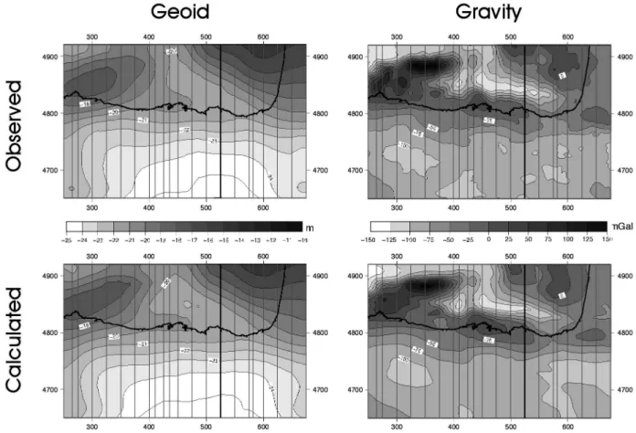
map of observed geoidal undulations approximately follows the distribution of long-wavelength highs and lows on the gravity map, suggesting that the main sources for the geoid anomalies lie at the crust-mantle boundary or above it. The effects of such crustal sources reproduce very well the shorter wavelength components of the geoidal undulations, placing additional constraints on the structure pro-posed by Pedreira et al. (2007) for this area. The longer wavelength components of the residual geoidal undulations were adjusted by trial and error modification of the lithospheric mantle and asthenospheric densities, and the topography of the boundary layer between these two bodies. The cor-relation coefficients between observed and comput-ed geoid and gravity anomalies are 0.99 and 0.98, respectively, with standard deviations of 0.36 m and 8.06 mGal.
ning in the Parentis Basin to the North (e.g. Pinet et al., 1987).
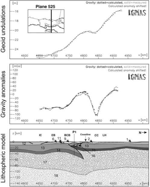
A preliminary low-pass filtered map of the LAB is shown in figure 4. Thicknesses in both the Iberian and
European-Cantabrian plates generally range between 85 and 95 km, with a small and discontinuous lithospheric root down to 110-125 km depth beneath the shoreline (approximately coincident with the trend of the crustal root).
Conclusions and future work
The results of this preliminary study suggest that the lithosphere in both the Iberian and European-Cantabrian plates has a similar thickness of 85-95 km, with a small and discontinuous root of an extra ~20-30 km maximum in the contact zone, approxi-mately beneath the crustal root.
The trend of this lithospheric root seems to be dis-rupted by ~N-S lineaments, although we must emphasize that several factors still need to be tested in order to achieve reliable results on the topography of the LAB, especially the influence of variable density values for the lithospheric and asthenospheric mantle and the effect of possible eclogitized crustal roots.
Figure 4. Preliminary low-pass filtered depth contour map of the lithosphere-asthenosphere boundary over the studied area.
References
ARDIZONE, J., MEZCUA, J. and SOCÍAS, I. (1989): Mapa Aeromagnético de España Peninsular, Instituto Geográfico Nacional, Madrid.
ALLER, J. and ZEYEN, H. J. (1996): A 2.5D interpretation of the Basque country magnetic anomaly (northern Spain): geodynami-cal implications. Geol. Rundsch., 85: 303-309.
AYALA, C., TORNÉ, M. and POUS, J. (2004): The lithosphere-asthenosphere boundary in the western Mediterranean from 3D joint gravity and geoid modelling: tectonic implications. Earth Planet. Sc. Lett., 209: 275-290.
AYARZA, P., MARTÍNEZ-CATALÁN, J. R., ÁLVAREZ-MARRÓN, J., ZEYEN, H. and JUHLIN, C. (2004): Geophysical constraints on the deep structure of a limited ocean-continent subduction zone at the North Iberian Margin. Tectonics, 23, TC1010, doi:10.1029/2002TC001487.
DÍAZ, J., GALLART, J., PEDREIRA, D., PULGAR, J. A., RUIZ, M., LÓPEZ, C. and GONZÁLEZ-CORTINA, J. M. (2003): Teleseismic imaging of alpine crustal underthrusting beneath N-iberia.
Geophys. Res. Lett., 30, 11. doi:10.1029/2003GL017073.
FEATHERSTONE, W. E. (1997): On the Use of the Geoid in Geophysics: A Case Study Over the North-West Shelf of Australia. Explor. Geophys., 28, 1: 52-57.
FERNÁNDEZ-VIEJO, G., GALLART, J., PULGAR, J. A., CÓRDOBA, D. and DAÑOBEITIA, J. J. (2000): Seismic signature of Variscan and Alpine tectonics in NW Iberia: Crustal structure of the Cantabrian Mountains and Duero basin. J. Geophys. Res., 105, B2: 3001-3018.
GALLASTEGUI, J. (2000): Estructura cortical de la Cordillera y Margen Continental Cantábricos: Perfiles ESCI-N. Trabajos de Geología, 22: 9-234.
GÖTZE, H. J., and B. LAHMEYER(1988): Application of three-dimensional interactive modelling in gravity and magnetics. Geophysics, 53, 8: 1096-1108.
GRANDJEAN, G., MÉNNECHET, C., DEBEGLIA, N. and BONIJOLY, D. (1998): Insuring the Quality of Gravity Data. Eos Trans. Am. Geophys. Union, 79, 18: 217-221.
LEDO, J., AYALA, C., POUS, J., QUERALT, P., MARCUELLO, A. and MUÑOZ, J. A. (2000): New geophysical constraints on the deep
structure of the Pyrenees. Geophys. Res. Lett., 27: 1037-1040.
MUÑOZ, J. A. (1992): Evolution of a continental collision belt: ECORS Pyrenees crustal balanced cross-section. In: K. R. MCCLAY (ed): Thrust Tectonics, Chapman and Hall, Boston, Massachusetts: 235-246.
PAVLIS, N. K., HOLMES, S. A., KENYON, S. C. and FACTOR, J. K.
(2008): An Earth Gravitational Model to Degree 2160: EGM2008. Geophys. Res. Abstr., 10, EGU2008-A-01891.
PEDREIRA, D., PULGAR, J. A., GALLART, J. and DÍAZ, J. (2003): Seismic evidence of Alpine crustal thickening and wedging from the western Pyrenees to the Cantabrian Mountains (north Iberia). J. Geophys. Res., 108, B4: doi:10.1029/2001JB001667.
PEDREIRA, D., PULGAR, J. A., GALLART, J. and TORNÉ, M. (2007): Three-dimensional gravity and magnetic modelling of crustal inden-tation and wedging in the western Pyrenees-Cantabrian Mountains, J. Geophys. Res., 112, B12405, doi:10.1029/2007JB005021.
PINET, B., MONTADERT, L. and ECORS SCIENTIFIC PARTY (1987): Deep seismic reflection and refraction profiling along the Aquitaine shelf (Bay of Biscay). Geophys. J. Roy. Astr. S., 89: 305-312.
North Pyrenean fault from teleseismic observations. Geology, 20: 157-160.
POUS, J., MUÑOZ, J. A., LEDO, J. J. and LIESA, M. (1995): Partial
melting of subducted continental lower crust in the Pyrenees. J. Geol. Soc. London, 152: 217-220.
PULGAR, J. A., GALLART, J., FERNÁNDEZ-VIEJO, G., PÉREZ -ESTAÚN, A., ÁLVAREZ-MARRÓN, J. and ESCIN GROUP (1996):
Seismic image of the Cantabrian Mountains in the western exten-sion of the Pyrenees from integrated ESCIN reflection and refrac-tion data. Tectonophysics, 264: 1-19.
SANDWELL, D. T. and SMITH, W. H. F. (1997): Marine gravity anomaly from Geosat and ERS-1 satellites. J. Geophys. Res., 102, B5: 10039-10054.
SCHMIDT, S. and GÖTZE, H. J. (1998): Interactive visualization and modification of 3D models using GIS functions. Phys. Chem. Earth Pt. A, 23, 3: 289-295.
SCHMIDT, S. and GÖTZE, H. J. (1999): Integration of Data Constraints and Potential Field Modelling - an Example from Southern Lower Saxony, Germany. Phys. Chem. Earth Pt. A, 24, 3: 191-196.
SEVILLA, M. J. (1995): A new gravimetric geoid in the Iberian Peninsula. In: New Geoids in the World, BGI, Bull. D’inf, 77 and
IGeS Bull., 4: 163-180.
SOURIAU, A. and M. GRANET(1995): A tomographic study of the lithosphere beneath the Pyrenees from local and teleseismic data. J. Geophys. Res., 100, B9:18117-18134.
TEIXELL, A. (1998): Crustal structure and orogenic material
budget in the west central Pyrenees. Tectonics, 17, 3: 395-406.
VERGÉS, J., MILLÁN, H., ROCA, E., MUÑOZ, J. A., MARZO, M., CIRÉS, J., DENBEZEMER, T., ZOETEMEIJER, R. and CLOETING, S. (1995): Eastern Pyrenees and related foreland basins: Pre-, syn-and post-collisional crustal-scale cross section. Mar. Petrol. Geol., 12, 8: 893-915.