www.andeangeology.cl
Timing of the magmatism of the paleo-Pacific border of Gondwana:
U-Pb geochronology of Late Paleozoic to Early Mesozoic igneous rocks of
the north Chilean Andes between 20° and 31°S
Víctor Maksaev1, Francisco Munizaga1, 2, Colombo Tassinari3
1 Departamento de Geología, Universidad de Chile, Plaza Ercilla 803, Santiago, Chile.
vmaksaev@ing.uchile.cl; fmunizag@ing.uchile.cl
2 Geología, Facultad de Ingeniería, Universidad Andrés Bello, Salvador Sanfuentes 2375, Santiago, Chile.
3 Instituto de Geociencias, Universidade de Sao Paulo, Rua do Lago, 562-Cidade Universitária CEP 05508-080, Sao Paulo, Brasil.
ccgtassi@usp.br
ABSTRACT. U-Pb zircon geochronological data provide record of about 130 Ma of igneous activity in the Andes of
northern Chile, which extended episodically from the latest Early Carboniferous to Early Jurassic (328-194 Ma). The overall U-Pb data show that volcanism and plutonism were essentially synchronous and major episodes of igneous ac-tivity developed during the Late Carboniferous to Mid-Permian (310 to 260 Ma) and from Late Permian to Late Triassic (255-205 Ma), with less prominent episodes in the mid-Carboniferous (330 to 320 Ma), and Early Jurassic (200-190 Ma). Thus, from the Carboniferous to the Early Triassic dominantly silicic magmatism developed along the Chilean segment of the southwestern border of Gondwana supercontinent. Further magmatism developed during the Mid-Late Triassic (250-194 Ma) was bimodal and synchronous with rift-related, continental and/or marine sedimentary strata related to the early stages of break-up of Gondwana. Most of the silicic volcanic rocks of the Precordillera and Domeyko Cordillera of northern Chile (21°30’ to 25°30’S) are older than the silicic rocks assigned to the Choiyoi succession in Argentina, being instead equivalent in age to Carboniferous to Early Permian marine sedimentary sequences present in the eastern Argentinean foreland. On the other hand, silicic volcanic successions exposed in the easternmost part of northern Chile are equivalent in age to the Choiyoi succession of the San Rafael Block of Argentina. An eastward expansion or migration of the volcanism during the Mid-Permian to Early Triassic is inferred, interpretation that is consistent with expansion of the volcanism at that time in Argentina. The timing of the Late Paleozoic to Early Jurassic magmatism is coincident with that of the Andes of Perú and of western Argentina according to the available U-Pb data, revealing a rather consistent evolution in time of the magmatism along the southwestern, paleo-Pacific border of Gondwana.
RESUMEN. Temporalidad del magmatismo del borde paleo-Pacífico de Gondwana: geocronología U-Pb de rocas ígneas del Paleozoico tardío a Mesozoico temprano de los Andes del norte de Chile entre los 20° y 31°S. Los datos de U-Pb en circón registran aproximadamente 130 Ma de actividad ígnea en los Andes del norte de Chile, la que se extendió episódicamente desde el Carbonífero temprano hasta el Jurásico temprano (328-194 Ma). Los datos globales de U-Pb indican que el volcanismo y plutonismo fueron esencialmente sincrónicos con episodios mayores desde el Carbonífero tardío al Pérmico Medio (310-260 Ma) y durante el Pérmico Tardío a Triásico Tardío (255-205 Ma) y episodios menos prominentes durante el Carbonífero medio (330-320 Ma) y el Jurásico Temprano (200-190 Ma). Desde el Carbonífero hasta el Triásico Temprano se desarrolló magmatismo predominantemente félsico a lo largo del borde suroccidental del supercontinente de Gondwana, mientras que durante el Triásico medio a tardío (250-194 Ma) se desarrolló magmatismo bimodal sincrónico con estratos sedimentarios continentales y/o marinos relacionados con extensión (rift), durante las etapas tempranas de la desintegración de Gondwana. La mayor parte de las rocas volcá-nicas silíceas de la precordillera y la cordillera de Domeyko en el norte de Chile (21°30’ a 25°30’S) son más antiguas que las rocas silíceas asignadas a la sucesión Choiyoi en Argentina, y son, en cambio, equivalentes en edad con las secuencias sedimentarias marinas del Carbonífero al Pérmico temprano presentes en el antepaís argentino al oriente. Por otra parte, las sucesiones volcánicas félsicas expuestas en la parte más oriental del norte de Chile, de la cordillera de Domeyko y de la cordillera Frontal al sur de 25°S son equivalentes en edad a la sucesión Choiyoi de Argentina. Se infiere una migración o expansión del volcanismo hacia el este durante el Pérmico Medio a Triásico Temprano, interpretación que es consistente con la expansión del volcanismo en Argentina durante ese período. La temporalidad del magmatismo del Paleozoico tardío a Mesozoico temprano es coincidente con la de los Andes de Perú y del oeste de Argentina, de acuerdo a los datos U-Pb disponibles, lo que revela una evolución temporal del magmatismo concordante a lo largo del borde suroeste del Gondwana.
Palabras clave: Geocronología, U-Pb, Andes, Gondwana, Choiyoi, Paleozoico, Carbonífero, Triásico.
1. Introduction
The Late Paleozoic-Early Mesozoic magmatism is a significant, but not completely understood geological event, which has been recognized along much of the length of western South America (e.g., Vaughan and Pankhurst, 2008). It is characterized by a high proportion of felsic volcanic rocks and granitic plutons over intermediate and mafic igneous rocks, and represents magmatism that developed along the southwestern paleo-Pacific border of Gondwana supercontinent (Llambías and Sato, 1990; Sato and Llambías, 1993; Mpodozis and Kay, 1992; Strazzere et al., 2006; Munizaga et al., 2008; Vaughan and Pankhurst, 2008; Rocha-Campos et al., 2011). The previous K-Ar dating of this extensive volcano-plutonic complex in northern Chile has yielded an overall range from 332 to 197 Ma for this magmatic activity (e.g., Huete et al., 1977; Nasi
et al., 1985; Mpodozis et al., 1993; Lucassen et al., 1999; Tomlinson et al., 2001; Tomlinson and Blanco, 2008). The K-Ar ages have mostly been obtained for intrusive rocks, since volcanic rocks commonly are altered or show low-grade metamorphism, which have prevented the application of the K-Ar dating method or produced inaccurate dates. More recent studies have provided a more accurate geochronological database of U-Pb dates for the Late Paleozoic-Early
Mesozoic igneous rocks of northern Chile (north of 31°S latitude), which we have compiled in Tables 1 and 2 (references therein), but also in Argentina (i.e., Pankhurst et al., 2006; Gulbranson et al., 2010; Rocha-Campos et al., 2011). In this contribution we present 41 new SHRIMP U-Pb dates for volcanic and plutonic rocks of northern Chile, which together with the compilation of U-Pb dates from previous studies, provide a more accurate timing for the Late Paleozoic to Early Jurassic magmatism of the north-Chilean segment of the southwestern border of Gondwana. The numerical ages are assigned to the International Stratigraphic Chart of the International Commission on Stratigraphy 2013 (Cohen et al., 2013).
2. Geological background
449
Andean Geology 41 (3): 447-506, 2014
Sample
Location (Geodetic WGS 84) U-Pb age
Latitude S Longitude W Lithology Ma±2σ Method Formation or Unit Reference
VAM-137 25°11’05.24” 69°18’12.33” Rhyolitic tuff 309.9±2.2 LA-ICP-MS La Tabla Venegas et al. (2013)
CHT-59 22°26’50.38” 68°57’18.24” Rhyolite 303.9±0.2 CA-TIMS Collahuasi Tomlinson and Blanco (2008)
D-9 28°46’30.58” 70°26’20.45” Rhyolite 300.8±4.6 LA-ICP-MS Cerro Bayo Salazar et al. (2009)
CHT-201 22°25’33.45” 68°58’25.42” Rhyolitic tuff 300.3±1.8 SHRIMP Collahuasi Tomlinson and Blanco (2008)
LVN-317 22°35’22.00” 68°55’50.78” Rhyolite 299.3±1.7 ID-TIMS Collahuasi Mpodozis et al. (1993)
CLL-76 21°02’09.83” 68°51’00.67” Dacite 298.8±2.2 SHRIMP Collahuasi Munizaga et al. (2008)
Unidentified 24°12’53” 69°03’40” Rhyolite 298.2±5.5 LA-ICP-MS La Tabla Jara et al. (2009)
78012 23°53’07.49” 69°00’45.45” Rhyolite 296.8±0.2 ID-TIMS La Tabla Cornejo et al. (2006)
VAM-070 25°17’53.27” 69°16’17.15” Rhyolitic tuff 294.6±2.1 LA-ICP-MS La Tabla Venegas et al. (2013)
Unidentified 24°12’53” 69°03’40” Andesite 294.4±4.6 LA-ICP-MS La Tabla Jara et al. (2009)
ESC-50 24°20’20.45” 69°01’04.46” Dacite 293±4 LA-ICP-MS La Tabla Urzúa (2009)
R990259 20°58’25.81” 68°41’59.07” Rhyolite 293±14 LA-ICP-MS Collahuasi Masterman (2003)
MF-650 23°41’19.97” 69°05’17.73” Rhyolite 292±5 ID-TIMS Sierra del Jardín Marinovic (2007)
MF-653 23°52’03.50” 69°09’27.15” Rhyolite 292±5 ID-TIMS Sierra del Jardín Marinovic (2007)
Unidentified 24°14’37” 69°02’57” Andesite 288.8±2.4 Uncertain La Tabla Hervé et al. (2012)
Unidentified 24°14’37.03” 69°02’57.31” Andesite 288.0±2.4 Uncertain La Tabla Hervé et al. (2012)
Unidentified 24°13’04.72” 69°03’46.42” Rhyolite 287.1±4.4 LA-ICP-MS La Tabla Jara et al. (2009)
ESC-45 24°16’20.86” 69°03’13.07” Andesite tuff 287±3 LA-ICP-MS La Tabla Urzúa (2009)
ESC-36 24°16’20.86” 69°03’13.07” Andesite tuff 286±2 LA-ICP-MS La Tabla Urzúa (2009)
ESC-47 24°13’04.73” 69°00’42.13” Andesite tuff 284±4 LA-ICP-MS La Tabla Urzúa (2009)
ESC-37 24°16’15.37” 69°02’43.88” Andesite tuff 282±2 LA-ICP-MS La Tabla Urzúa (2009)
Unidentified 22°25’13” 68°56’58” Dacite tuff 279±9 LA-ICP-MS Collahuasi Tomlinson and Blanco (2008)
Unidentified 22°24’50” 68°57’18” Dacite tuff 273.5±11.0 LA-ICP-MS Collahuasi Tomlinson and Blanco (2008)
T
iming
of
The
magma
Tism
of
The
paleo
-p
acific
border
of
g
ondw
ana
:
U-p
b
geochronology
...
Sample
Location (Geodetic WGS 84) U-Pb age
Latitude S Longitude W Lithology Ma±2σ Method Formation or Unit Reference
DCC-130 25°34’42.40” 69°05’34.66” Rhyolite 262.9±2.0 ID-TIMS La Tabla Cornejo et al. (2009)
CV-130321-02 25°01’53.27” 69°13’45.52” Altered tuff 259.0±3.4 LA-ICP-MS La Tabla Venegas et al. (2013)
CC-44-130-138-168 23°40’06” 68°00’50” Ignimbrite 248±3 ID-TIMS Peine Group Breitkreuz and Van Schmus
(1996)
Unidentified 23°09’ 68°36’ Tuff 240.8±0.3 ID-TIMS El Bordo Basso and Marinovic (2003)
Unidentified 23°09’ 68°36’ Tuff 238.7±0.4 ID-TIMS El Bordo Basso and Marinovic (2003)
CHT-192 22°25’36.5” 68°59’17.5” Andesitic breccias 235.4±1.6 SHRIMP Quetena Tomlinson and Blanco (2008)
CHT-193 22°25’34” 68°59’24.3” Volcanoclastic
sandstone 234.5±3.2 SHRIMP Quetena Tomlinson and Blanco (2008)
BF-225 23°00’16.35” 69°59’21.41” Rhyolitic tuff 233±12 ID-TIMS Sierra Miranda Basso (2004)
DCC-124 25°59’30.40” 69°19’13.96” Rhyolite 232.9±0.2 ID-TIMS Quebrada del
Salitre Cornejo et al. (2009)
Unidentified 22°12’51” 68°51’25” Dacite 231.6±0.5 ID-TIMS Cerros de
Chuquicamata Tomlinson and Blanco (2008)
St-62d 28°42’35.34” 70°24’00.99” Rhyolitic tuff 222.8±2.1 LA-ICP-MS San Félix Padel et al. (2012)
BF-2 23°04’11.18” 69°47’38.55” Rhyolite 220±19 ID-TIMS Sierra de Miranda Basso (2004)
FO 06 95 29°49’54.3” 70°30’38.7” Dacitic ignimbrite 219.5±1.7 SHRIMP Las Breas Hervé et al. (2014)
ST-93Ad 28°39’32.42” 70°09’50.23” Rhyolitic tuff 217.9±1.4 LA-ICP-MS La Totora Salazar et al. (2012, 2013)
ST196d 28°34’03.42” 70°08’22.65” Rhyolitic tuff 216.2±1.6 LA-ICP-MS La Totora Salazar et al. (2013)
CV-111212-02 25°17’58.75” 69°09’14.64” Andesite 214.2±2.0 LA-ICP-MS Quebrada del
Salitre Venegas et al. (2013)
VAM-167 25°07’06.16” 69°11’22.20” Dacite 212.8±2.0 LA-ICP-MS Quebrada del
Salitre Venegas et al. (2013)
ST-175d 28°47’44.23” 70°24’48.83 Rhyolitic tuff 212.4±2.6 LA-ICP-MS San Félix Salazar et al. (2013)
ST-65d 28°41’09.64” 70°23’16.60” Basaltic andesite 210.4±2.9 LA-ICP-MS La Totora Salazar et al. (2013)
451
Andean Geology 41 (3): 447-506, 2014
Sample
Location (Geodetic WGS84) U-Pb age
Latitude S Longitude W Lithology Ma±2σ Method Reference
GP-2089 30°44’19.54” 70°30’17.56” Foliated muscovite-biotite granite 328.1±2.8 SHRIMP Pineda and Calderón (2008)
VAM-053 25°15’29.74” 69°17’04.78” Rhyolitic porphyry 328.3±3.4 LA-ICP-MS Venegas et al. (2013)
VAV 25°23’00.03” 69°05’02.91” Monzogranite 323.9±2.6 LA-ICP-MS Venegas et al. (2013)
Unidentified 23°40’30.56” 69°31’46.70” Monzogranite 310.1±4.8 ID-TIMS Cortés (2000)
CLL-238 20°58’04.34” 68°42’24.01” Rhyolitic porphyry 308.5±2.2 SHRIMP Munizaga et al. (2008)
CLL-75 21°02’09.81” 68°50’39.71” Rhyolitic porphyry 307.9±2.8 SHRIMP Munizaga et al. (2008)
CLL-114 20°58’04.34” 68°42’24.01” Rhyolitic porphyry 304.6±3.2 SHRIMP Munizaga et al. (2008)
CLL-237 20°57’54.34” 68°42’28.01” Rhyolitic porphyry 303.9±3.0 SHRIMP Munizaga et al. (2008)
Unidentified 21°59’49” 68°52’47” Rhyolitic porphyry 303.8±0.7 ID-TIMS Tomlinson and Blanco (2008)
CLL-44 20°59’59.33” 68°49’01.01” Granitic porphyry 303.2±2.0 SHRIMP Munizaga et al. (2008)
LVN-291 22°39’58.46” 68°57´11.24” Foliated diorite 303±5 ID-TIMS Mpodozis et al. (1993)
Unidentified 21°40’06” 68°49’59” Rhyolitic porphyry 302.4±0.8 ID-TIMS Tomlinson and Blanco (2008)
Unidentified 24°17’03” 69°03’08” Tonalite 300.1±3.5 Uncertain Hervé et al. (2012)
CV-120118-05 25°02’08.20” 69°01’17.56” Rhyolitic porphyry 299.4±2.5 LA-ICP-MS Venegas et al. (2013)
ZERD356 24°12´50.10” 69°03’19.82” Quartz Porphyry 298.9±2.6 SHRIMP Urzúa (2009)
CLL-223 20°58’08.70” 68°42’17.56” Rhyolitic porphyry 298.3±2.1 SHRIMP Munizaga et al. (2008)
84-22-12 22°40’15” 68°55’00” Granite 298.0±1.5 ID-TIMS Damm et al. (1990)
CLL-85 21°09’54.54” 68°39’42.14” Rhyolitic porphyry 297.6±2.4 SHRIMP Munizaga et al. (2008)
CLL-221 20°59’21.05” 68°38’09.68” Dacitic porphyry 296.9±4.3 SHRIMP Munizaga et al. (2008)
Unidentified 22°16’30” 68°51’20” Granite 296.9±2.1 ID-TIMS Tomlinson and Blanco (2008)
Unidentified 24°17’03” 69°03’43” Monzodiorite porphyry 296.8±3.2 Uncertain Hervé et al. (2012)
Unidentified 24°17’03” 69°03’08” Monzogranite porphyry 296.6±4.4 Uncertain Hervé et al. (2012)
VAV-006 25°18’35.21” 69°09’04.60” Dacitic porphyry 296.3±2.9 LA-ICP-MS Venegas et al. (2013)
T
iming
of
The
magma
Tism
of
The
paleo
-p
acific
border
of
g
ondw
ana
:
U-p
b
geochronology
...
Sample
Location (Geodetic WGS84) U-Pb age
Latitude S Longitude W Lithology Ma±2σ Method Reference
VAM-031 25°05”30.67” 69°14’03.20” Syenogranite 295.6±2.6 LA-ICP-MS Venegas et al. (2013)
ST-72d 28°42’56.55” 70°17’50.35” Muscovite-biotite Granodiorite 295.4±3.3 LA-ICP-MS Coloma et al. (2012)
QFP1 24°11’59.70” 69°03’12.71” Rhyolitic Porphyry 294.2±2.4 SHRIMP Urzúa (2009)
CAB-267A 24°35’36” 69°10’48” Foliated biotite-muscovite tonalite 294±3 ID-TIMS Marinovic et al. (1995)
AM-25 30°56’53.40” 70°30’35.30” Foliated tonalite 293.7±2.4 SHRIMP Pineda and Calderón (2008)
ZERD958 24°12’56” 69°02’57” Monzogranite porphyry 293.0±6.0 LA-ICP-MS Urzúa (2009)
CLL-73 21°01’53.71” 68°50’39.72” Granitic porphyry 292.7±1.9 SHRIMP Munizaga et al. (2008)
CAB-301A 24°36’46” 69°12’19” Foliated hornblende-biotite tonalite 292±5 ID-TIMS Marinovic et al. (1995)
ST-4d 28°41’39.54” 70°17’26.99” Biotite tonalite 291.5±3.4 LA-ICP-MS Coloma et al. (2012)
7 25°54’38” 70°37’00” Syenogranite 291.8±14.3 ID-TIMS Berg et al. (1983)
FO 06 96 29°51’42” 70°30’21” Hornblende-biotite granodiorite 291.2±2.7 SHRIMP Hervé et al.(2014)
ZAL3 24°13’13” 69°04’25” Rhyolitic porphyry 290±4 LA-ICP-MS Richards et al. (1999)
ESC-49 24°18’45.22” 69°59’18.25” Monzonite 290±2 Uncertain Urzúa (2009)
FO 06 98 30°08’08” 70°24’39” Biotite-muscovite granite 289.7±1.8 SHRIMP Hervé et al. (2014)
LVN-293 22°39’38.95” 68°57’46.29” Biotite granite 288.3±1.4 ID-TIMS Mpodozis et al. (1993)
FO 06 94 29°50’46.0” 70°22’59.9” Foliated hornblende-biotite tonalite 288.2±1.5 SHRIMP Hervé et al. (2014)
CAB-252A 24°38’45” 69°12’22” Foliated biotite tonalite 288±5 ID-TIMS Marinovic et al. (1995)
Unidentified 24°14’37.03” 69°02’57.31” Quartz Monzodiorite porphyry 287.6±3.3 Uncertain Hervé et al. (2012) CON-90-1 28°51’57.58” 70°17’14.28” Hornblende-biotite granodiorite 285.7±0.6 ID-TIMS Pankhurst et al. (1996)
78009 23°51’55.95” 69°01’29.79” Diorite 283.6±2.8 ID-TIMS Cornejo et al. (2006)
MF-651 23°51’38.64” 69°03’38.12” Granite 279.0±2.4 ID-TIMS Marinovic (2007)
CAB-292A 24°59’45” 69°10’12” Muscovite-biotite granodiorite 277±4 ID-TIMS Marinovic et al. (1995)
78001 23°53’29.88” 69°00’40.85” Diorite 273±4 ID-TIMS Cornejo et al. (2006)
453
Andean Geology 41 (3): 447-506, 2014
Sample
Location (Geodetic WGS84) U-Pb age
Latitude S Longitude W Lithology Ma±2σ Method Reference
84-19-01 23°40’44.23” 68°23’49.96” Granodiorite 268±5 ID-TIMS Damm et al. (1990)
CL2-HN11/07 23°45’30.52” 68°21’07.38” Monzodiorite 267.3±2.5 LA-ICP-MS Niemeyer (2013)
JA01 28°45’53.92” 70°10’11.99” Foliated biotite granodiorite 266.1±3.5 LA-ICP-MS Álvarez et al. (2013)
CL4-HN09 23°41’10.18” 68°22’35.49” Monzodiorite 266.1±3.5 LA-ICP-MS Niemeyer (2013)
CT-358d 28°58’29.89” 70°14’30.39” Tonalite 257.0±1.9 LA-ICP-MS Salazar et al. (2013)
Di01-HN09 23°43’15.47” 68°26’10.46” Diorite 256.0±2.0 LA-ICP-MS Niemeyer (2013)
CT-358Bd 28°58’29.89” 70°14’30.39” Felsic band of mylonite 255.3±4.0 LA-ICP-MS Salazar et al. (2013)
FO 06 87 30°05’37.2” 70°04’31.9” Clinopyroxene gabbro 255.2±1.8 SHRIMP Hervé et al. (2014)
CL15-HN04 23°46’41.20” 68°24’19.23” Feldspar porpyhry 254.2±2.3 LA-ICP-MS Niemeyer (2013)
D-1 20°49’25” 68°42’00” Granite 252.5±2.8 ID-TIMS Vergara and Thomas (1984)
CHIN01-HN9 23°41’56.42” 68°23’09.91” Monzogranite 252.0±2.8 LA-ICP-MS Niemeyer (2013)
IM83-4 30°05’22.63” 70°00’26.90” Granitic porphyry 249.7±3.2 ID-TIMS Martin et al. (1999)
CLL-297 20°50’49.68” 68°45’05.31” Granitic porphyry 248.7±3.3 SHRIMP Munizaga et al. (2008)
Ja-02 28°58’39.93” 70°10’12.87” Biotite granite 247.7±3.4 LA-ICP-MS Álvarez et al. (2013)
ST-16d 28°59’06.54” 70°12’49.77” Muscovite-biotite granodiorite 247.0±3.1 LA-ICP-MS Coloma et al. (2012)
FO10104B 28°57’46.4” 70°14’51.7” Biotite leucogranite 245.0±2.3 SHRIMP Hervé et al. (2014)
R200085 20°58’38.69” 68°41’55.38” Granodiorite porphyry 245±12 LA-ICP-MS Masterman (2003)
CLL-30 21°00’04.34” 68°36’54.02” Dacitic porphyry 244.8±2.5 SHRIMP Munizaga et al. (2008)
CLL-32 20°50’22.34” 68°45’10.00” Granitic porphyry 243.2±2.1 SHRIMP Munizaga et al. 2008
FO10100 28°58’27.5” 70°10’05.8” Leucogranite 242.6±2.2 SHRIMP Hervé et al. (2014)
IM-108.1 29°19’20.66” 70°01’46.95” Quartz Porphyry 242.5±1.5 ID-TIMS Martin et al. (1999)
IM-113.1 29°19’09.17” 70°02’03.51” Dacite porphyry 242.0±1.5 ID-TIMS Martin et al. (1999)
Ja-94 28°59’26.23” 70°13’01.01” Biotite-hornblende tonalite 241.7±3.0 LA-ICP-MS Álvarez et al. (2013)
T
iming
of
The
magma
Tism
of
The
paleo
-p
acific
border
of
g
ondw
ana
:
U-p
b
geochronology
...
Sample
Location (Geodetic WGS84) U-Pb age
Latitude S Longitude W Lithology Ma±2σ Method Method
Unidentified 22°22’40” 68°54’50” Dacite dike 237.6±1.4 LA-ICP-MS Tomlinson and Blanco (2008)
Unidentified 22°22’40” 68°54’50” Granodiorite 233.6±1.5 LA-ICP-MS Tomlinson and Blanco (2008)
Unidentified 22°16’02” 68°53’07” Granodiorite 233.1±2.2 SHRIMP Tomlinson and Blanco (2008)
Unidentified 22°16’02” 68°53’07” Granodiorite 231.4±2.0 SHRIMP Tomlinson and Blanco (2008)
I-21 26°13’05” 70°35’36” Monzogranite 230±8 ID-TIMS Berg and Baumann (1985)
QT-460 22°15’20” 68°52’10” Granodiorite 229.0±2.0 ID-TIMS Tomlinson et al. (2001)
QT-459 22°17’13” 68°53’14” Granodiorite 227.2±2.0 ID-TIMS Tomlinson et al. (2001)
ESC-51 24°11’27.64” 69°01’35.05” Feldspar porphyry 227±3 LA-ICP-MS Urzúa (2009)
FO 06 89 29°58’05.8” 70°06’37.7” Porphyritic granite 225.9±1.8 SHRIMP Hervé et al. (2014)
Unidentified 22°22’40” 68°54’50” Granodiorite 224±5 LA-ICP-MS Tomlinson and Blanco (2008)
ESC-52 24°16’20.88” 68°58’20.28” Feldspar porphyry 223±4 LA-ICP-MS Urzúa (2009)
Unidentified 22°22’40” 68°54’50” Dacitic dike 222.0±4.9 LA-ICP-MS Tomlinson and Blanco (2008)
II-15 26°20’28” 70°28’58” Monzogranite 217±12 ID-TIMS Berg and Baumann (1985)
FO 06 97 30°07’01.7” 70°26’11.4” Biotite granite 215.8±1.2 SHRIMP Hervé et al. (2014)
FO 06 93 29°52’39.5” 70°20’22.2” Cordierite-muscovite granodiorite 215.6±1.9 SHRIMP Hervé et al. (2014)
MEJ-18024 23°05’46.1” 70°30’54.5” Hornblende-biotite tonalite 208±2 SHRIMP Casquet et al. (2013)
Unidentified 23°24’09” 69°02’52” Dacitic porphyry 206.1±1.0 ID-TIMS Marinovic and García (1999)
The Choiyoi igneous province consists of volcano-plutonic complexes (Kay et al., 1989; Llambías et al., 1993; Llambías and Sato, 1995) that cover an estimated area of ~500,000 km2, which extends for
about 2,500 km, from the Collahuasi area in north-ern Chile (20°30’S) to Neuquén and the northnorth-ern Patagonian Andes of southern Argentina (44°S; Jordan et al., 1983; Mpodozis and Ramos, 1989; Ramos and Folguera, 2009; Ramos, 2009). Besides, it is also correlated with the Mitu Group (Carlier
et al., 1982) and the Yura Group of southern Perú (Sempere et al., 2002; Boekhout et al., 2013), and geological and geochronological data from magmatic and migmatitic rocks of the Northern Andes have shown that the Late Paleozoic to Triassic magmatism was also extensively recorded from northern Perú to the Central Cordillera of the Colombian Andes (Restrepo et al., 1991; Noble et al., 1997; Ordóñez and Pimentel, 2002; Vinasco et al., 2006; Chew et al., 2007; Ibáñez-Mejía et al., 2008; Cardona et al., 2008, 2009).
The main outcrops of Late Paleozoic to Early Jurassic igneous rocks in northern Chile are ex-posed in a semi-continuous belt from about 21°S to 31°S latitudes. These rocks are prominent along the Domeyko Cordillera (24° to 27°S) and its northern extension, the so called Chilean Precordillera (20° to 24°S), but also along the High Andes from 27° to 31°S, which are commonly referred as Chilean Frontal Cordillera. Late Carboniferous and Triassic granitic plutons are also scattered from 21°S latitude southwards along the Coastal Cordillera and then forming an almost continuous intrusive belt between 33° to 38°S (e.g., Deckart et al., 2014).
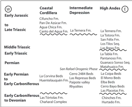
The isolation of outcrops, fault-bounded blocks, volcanic deposits of similar petrographic composi-tions, lack of accurate geochronological data, and the absence of guide horizons, have made difficult to know the exact stratigraphic-structural relation-ships between separate exposures. Thus, a number of lithostratigraphic units were assigned by differ-ent authors to specific time-spans and correlated with other exposures, which at times proved to be incorrect as geochronological data become avail-able. This is reflected by a profuse stratigraphic nomenclature used in previous studies to refer to Late Paleozoic to Early Mesozoic successions of the Andes of northern Chile (e.g., Charrier et al., 2007); for unambiguousness figures 1 and 2 illustrate preliminary stratigraphic schemes for two segments
of the Andes of northern Chile, modified according to the new geochronological data.
The exposed Late Paleozoic to Mid-Triassic volcanic succession along the Andes in northern Chile has uneven thickness, visible successions typically range between 750 and 2,600 m, but exceeding 3,200 m in the Collahuasi area of the Precordillera (21°S latitude; Vergara and Thomas, 1984). These successions are mostly formed of felsic volcanic rocks that include extensive rhyo-litic and dacitic ash flow tuffs (ignimbrites), and banded rhyolite and dacitic domes and lava-flows. A lesser proportion is composed of basaltic and andesitic lavas, and pyroclastic deposits of the same petrographic composition. Sedimentary intercalations of volcanic sandstones, minor con-glomerates, and local limestones (i.e., Collahuasi area; Vergara and Thomas, 1984), are also locally present. The volcanic successions unconformably overlie Devonian to Early Carboniferous shallow-marine, sedimentary successions, but its base is only locally exposed (Mercado, 1982; Niemeyer
et al., 1985, 1997; Mpodozis and Cornejo, 1988; Nasi et al., 1990; Marinovic et al., 1995). In addi-tion, calcareous and terrigenous, shallow-marine sedimentary successions, containing Early Per-mian fossils are exposed in the western foothills of the High Andes and in the Central Depression. These sedimentary units represent Early Permian carbonate sedimentation within a shallow-marine platform, but some of them are either overlying or interstratified with rhyolitic rocks (Sepúlveda and Naranjo, 1982; Marinovic et al., 1995; Iriarte et al., 1996; Cortés, 2000; Díaz-Martínez et al., 2000).
Middle to Late Triassic successions are sedimen-tary-volcanic in nature and are separated from older rocks by unconformities. A bimodal suite composed of basalts and rhyolites, locally with pillow lavas, and associated rhyolitic and dacitic sills, domes and ash-flow deposits occur within the Mid-Late Triassic to Early Jurassic successions (Naranjo and Puig, 1984; Suárez and Bell, 1992; Tomlinson et al., 1999; Cornejo and Mpodozis, 1996, 1997; Cornejo
et al., 2009). The Late Triassic to Early Jurassic magmatism is fairly common, but it has been poorly investigated (e.g., Franz et al., 2006), and has not always been recognized as a distinct unit from older Carboniferous-Triassic rocks.
Early Sierra del Tigre Fm. Las Tórtolas Fm.
Juan de Morales Fm. Quipisca Fm. Cerro El Árbol Fm. Riolitas de Sierra Co. La Ballena Fm. Profeta Fm. Qda. del Salitre Fm.
Late Triassic strata assigned to the Agua Dulce Fm. Pular Fm.
Sierra de Varas Fm.
Cerros de Cuevitas Fm.
FIG. 1. Late Paleozoic to Early Jurassic stratigraphic units of northern Chile from 20° to 26°S, ordered according to the new geochronological data. The different units are ordered geographically from western (left) to eastern exposures (right) and face each other according to their approximate latitude of occurrence. The reader is referred to the work of Charrier et al. (2007 and references therein) for the units that are not mentioned in text.
Early Carboniferous
Pan De Azúcar Fm. Agua Chica Fm. Canto del Agua Fm.
La Tabla Fm.
San Rafael Orogenic Phase
plutons were emplaced in different segments along the Precordillera (21°-24°S), Domeyko Cordillera (24°-27°S) and an extensive sector of the Chilean Frontal Cordillera between 28° and 31°S (Figs. 3 and 4) is formed of granitic rocks of Late Paleozoic to Triassic age (Parada et al., 1981, 2007; Nasi et al., 1985; Mpodozis and Kay, 1990, 1992; Mpodozis et al., 1993; Cornejo et al., 1998; Tomlinson et al., 1999; Tomlinson et al., 2001; Tomlinson and Blanco, 2008; Hervé et al., 2014). Scattered Late Carboniferous and Triassic granitic plutons also extend from 21°S latitude southwards along the Coastal Cordillera, and then forming an almost continuous intrusive belt between 33° to 38°S (Berg et al., 1983; Shibata et al., 1984; Maksaev and Marinovic, 1980; Skarmeta and Marinovic, 1981; Berg and Baumann, 1985; Mpodozis and Kay, 1992; Parada et al., 2007; Deckart et al., 2014). Some of the Carboniferous and Early Permian plutons show foliation with preferred orientation of their tabular minerals, and local bands of mylonites with high-temperature, ductile, shearing deformation (Nasi et al., 1985; Ribba et al., 1988; Marinovic et al., 1995; Murillo
et al., 2012; Hervé et al., 2014). Close associations of granitic plutons and ignimbrites in the Andes have been interpreted as large relict calderas (Davidson et al., 1985; Breitkreuz, 1995; Tomlinson et al., 2001). In addition, a belt of porphyry copper prospects and hydrothermal alteration zones are associated with the Permian and Triassic intrusions in Chile and Argentina (Sillitoe, 1977; Camus, 2003; Cornejo et al., 2006; Tomlinson and Blanco, 2008).
The Carboniferous to Mid-Triassic igneous rocks constitute a calc-alkaline to potassium-rich calc-alkaline suite, are metaluminous to peralumi-nous in composition, and have overall geochemical characteristics consistent with subduction-related, magmatic arc origin, but with evolution into exten-sional magmatism and significant involvement of crustal melts, evidencing significant crustal recycling (Nasi et al., 1985; Kay et al., 1989; Breitkreuz et al., 1989; Mpodozis and Kay, 1990, 1992; Mpodozis
et al., 1993; Breitkreuz and Zeil, 1994; Marinovic
et al., 1995; Lucassen et al., 1999; Llambías et al., 2003; Parada et al., 2007; Urzúa, 2009; Vásquez et al., 2011; Parada, 2013). Brown (1990) compared the major and trace elements geochemistry of the Permian to Middle Triassic Coastal granitic plutons at latitude 26°S with those exposed some 120 km to the east in the High Andes, showing their similar
compositions with subduction-related affinity, and concluded that they were part of the same magmatic arc split during Mesozoic extension.
The Middle to Late Triassic igneous rocks show a distinct bimodal composition with a within plate tendency, consistent with an origin in an extensional, rift-related setting (Vergara et al., 1991; Parada et al., 1991; Morata et al., 2000; Vásquez et al., 2011; Parada, 2013).
3. Previous U-Pb geochronological data
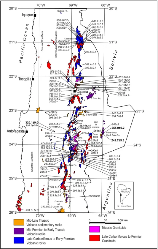
U-Pb geochronological data for Late Paleozoic to Early Mesozoic rocks compiled from previous studies are presented in Tables 1 and 2 and figures 3 and 4. The oldest zircon U-Pb ages compiled for volca-nic rocks range from 309.9±2.2 to 273.5±11.0 Ma (Table 1; Fig. 3); these rocks are exposed from 20°30’ to 25°30’S in a ~50 km wide, longitudinal belt along ~69°W longitude along the Precordillera and the Domeyko Cordillera (Fig. 3), and according to the U-Pb data represent a Late Carboniferous to Early Permian, felsic volcanism and subordinate intermediate and basic volcanic rocks, and minor sedimentary intercalations (Collahuasi, Agua Dulce and La Tabla Formations, and the Sierra del Jardín Rhyolites; Vergara and Thomas, 1984; Mpodozis et al., 1993; Marinovic and García, 1999; Masterman, 2003; Cornejo et al., 2006; Marinovic, 2007; Munizaga
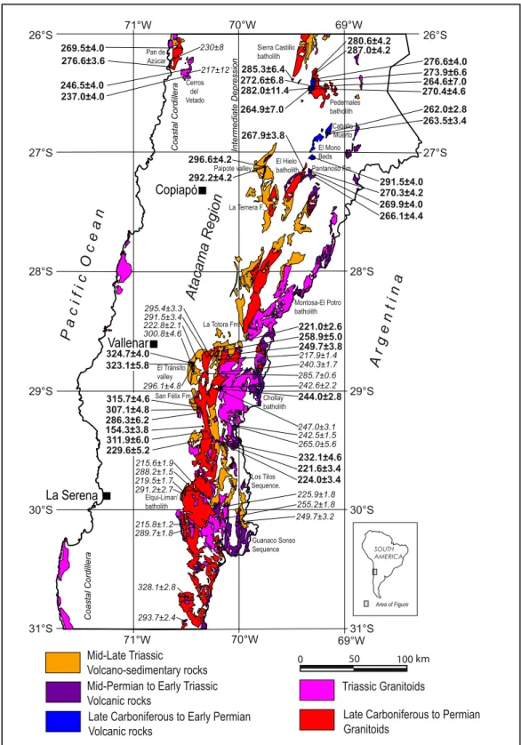
et al., 2008; Tomlinson and Blanco, 2008; Urzúa, 2009; Jara et al., 2009; Hervé et al., 2012). The Late Carboniferous to Early Permian volcanism is less known southward of 25°30’S, but a U-Pb zircon age of 300.8±4.6 Ma has been reported by Salazar et al. (2013) for rhyolites outcropping in the El Tránsito river valley in the High Andes, 65 km west of the divide (28°46’S; Fig. 4).
Rhyolitic volcanic rocks exposed along the Domeyko Cordillera and Frontal Cordillera south of 25°30’S latitude have yielded U-Pb ages of 262.9±2.0 and 265.0±5.6 Ma (Table 1; Fig. 4), thus essentially representing a Mid-Permian felsic vol-canism, which has been previously ascribed to the to the Permian-Triassic (Martin et al., 1999) or to the Carboniferous-Permian (Cornejo et al., 2009).
Iquique
Late Carboniferous to Permian Granitoids
Triassic Granitoids
Late Carboniferous to Early Permian Volcanic rocks
Mid-Permian to Early Triassic Volcanic rocks Cas & Peine Fm. Collahuasi Fm.
31°S
Late Carboniferous to Permian Granitoids
Triassic Granitoids
Late Carboniferous to Early Permian Volcanic rocks
Mid-Permian to Early Triassic Volcanic rocks
flat at about 23°30’S (Fig. 3). Thus, these eastern-most outcrops of northern Chile represent an Early to Middle Triassic volcanism, which originally was assigned to the Late Permian by Breitkreuz and van Schmus (1996), as befitted to the geologic time scale in that year.
Middle Triassic to Early Jurassic volcanism has yielded U-Pb dates from 249.7±3.8 to 194.0±9.2 Ma (Table 1). During this time span andesitic to basaltic volcanism coexisted with rhyolitic volcanism (bimodal volcanism), and was synchronous with rift-related, continental and/or marine sedimentary deposits widely distributed in northern Chile (Naranjo and Puig, 1984; Charrier, 1979; Suaárez and Bell, 1992; Martin et al., 1999; Tomlinson et al., 1999; Cornejo and Mpodozis, 1996, 1997; Cornejo et al., 2009).
The zircon U-Pb ages for intrusive rocks exposed along the High Andes and Domeyko Cordillera range from 328.1±2.8 to 205.9±0.5 Ma (Table 2), overlapping with the corresponding interval of U-Pb dates of volcanic rocks (ca. 310 to 194 Ma; Table 1). The intrusions include coarse-grained granitoids and porphyritic felsic plutons; the late are closely related to the volcanic rocks. Foliated plutons (ductile deformation) show U-Pb ages in the range 328 to 288 Ma (Table 2).
There are scarce and inaccurate previous U-Pb dates for granitic plutons scattered along the Coastal Cordillera of northern Chile from 21° to 31°S, which range from 291.8±14.3 to 217±12 Ma (Berg et al., 1983; Berg and Baumann, 1985). Yet, a number of whole rock Rb-Sr dates that range from 296±5.4 to 222±3 Ma have been published (Berg et al., 1983; Shibata et al., 1984; Berg and Baumann, 1985), and biotite K-Ar dates of 318±6 and 322±5 Ma (Maksaev and Marinovic, 1980; Skarmeta and Marinovic, 1981). Besides, eight U-Pb ages ranging from 319.6±2.4 to 308.9±2.4 Ma have been recently obtained for the granitoids that are exposed from 33° to 38°S along the Coastal Cordillera of central-southern Chile (Deckart et al., 2014).
4. Analytical methods
SHRIMP II U-Pb analyses of zircon grains were carried out at the Geochronological Research Center (Centro de Pesquisas Geocronológicas) of the Sao Paulo University, Brazil. Zircon grains were obtained from rock samples following normal mineral sepa-ration procedures in Universidad de Chile, which
included crushing, washing, and heavy liquid and magnetic separation. Hand-picked zircon grains were mounted in epoxy, together with chips of the Temora reference zircons, sectioned approximately in one half, and polished in Brazil. Cathodoluminescence (CL) Scanning Electron Microscope (SEM) images were prepared for all zircons. The CL images were used to decipher the internal structures of the sectioned grains and to ensure that the ~20 μm SHRIMP spot was wholly within a single age component within the sectioned grains. Uranium-Th-Pb analyses were made using a sensitive high resolution ion microprobe (SHRIMP II) for determining the respective zircon Concordia U-Pb ages following procedures given in Williams (1998, and references therein). Each analy-sis conanaly-sisted of six scans through the mass range, with a Temora U-Pb reference grain analyzed for every three unknown analyses. The data have been reduced using the SQUID Excel Macro of Ludwig (2001); U-Pb ratios have been normalized relative to a value of 0.0668 for the Temora reference zircon, equivalent to an age of 417 Ma (Black et al., 2003). Uncertainties given for individual analyses (ratios and ages) are at the one-sigma level (Appendix 2). Tera and Wasserburg (1972) concordia plots, and mean U-Pb age calculations were carried out using ISOPLOT/EX (Ludwig, 2003). The data tabulations for all 43 samples are presented in Appendix 1 and 2.
5. Results
The new SHRIMP U-Pb zircon concordia ages are summarized in Tables 3 and 4 for volcanic and intrusive rocks, respectively and sample locations are shown in figures 3 and 4; Tera-Wasserburg concor-dia plots and SHRIMP zircon U-Pb analytical data are included in the Appendix 1 and 2, respectively.
5.1. Volcanic rocks
in the El Tránsito river valley (at 28°46’S; Fig. 4), which were previously mapped as the Permian to Triassic Pastos Blancos Formation (Moscoso et al., 2010), but were recognized as an older separate unit named Cerro Bayo Formation by Salazar et al. (2013). Besides, a U-Pb age of 320.1±9.0 Ma was obtained for an ignimbrite outcropping in the Intermediate Depression of the Antofagasta Region, which is
part of a rhyolitic volcanic succession that underlies and is partly interfingered with carbonate strata that contains Early Permian marine fossils in its upper section (Cerro del Árbol Formation; Marinovic et al., 1995; Marinovic, 2007). In addition, U-Pb ages of 296.6±4.2 and 292.2±4.2 Ma were obtained for rhyolites that are part of a succession exposed in the Paipote valley which was assigned to the Pantanoso TABLE 3. SUMMARY OF NEW SHRIMP ZIRCON U-Pb CONCORDIA AGES FOR VOLCANIC ROCKS.
Sample Location (Geodetic-WGS 84) Lithology U-Pb age Unit
Latitude S Longitude W Ma±2σ
CHY-50 28°46’19.39” 70°26’15.80” Rhyolite 324.7±4.0 Cerro Bayo Beds
CHY-11 28°46’38.77” 70°25’49.51” Rhyolite 323.1±5.8 Cerro Bayo Beds
FO-11-35 23°38’04.96” 69°30’27.27” Rhyolitic ignimbrite 320.1±9.0 Cerro del Árbol Fm.
CHY-29 27°06’58.71” 69°44’28.75” Rhyolite 296.6±4.2 Paipote valley
CHY-31 27°06’50.51” 69°43’59.49” Rhyolite 292.2±4.2 Paipote valley
CHY-33 27°03’15.21” 69°17’42.15” Andesitic tuff 291.5±4.0 El Mono Beds CHY-14 26°28’49.60” 69°19’04.29” Rhyolitic tuff 282.0±11.4
*311.3±8.2 La Tabla Formation CHY-18 26°25’11.76” 69°16’56.65” Rhyolitic tuff 276.6±4.0 La Tabla Formation CHY-17 26°26’05.81” 69°16’58.77” Rhyolitic tuff 273.9±6.6 La Tabla Formation CHY-15 26°28’42.56” 69°19’12.39” Rhyolitic tuff 272.6±6.8 La Tabla Formation CHY-22 26°28’41.13” 69°18’13.19” Banded rhyolite 270.4±4.6 La Tabla Formation
CHY-25 27°09’37.98” 69°18’42.56” Dacite 270.3±4.2 Pantanoso Formation
CHY-27 27°10’24.48” 69°18’31.21” Dacitic tuff 269.9±4.0 Pantanoso Formation CHY-26 27°09’49.87” 69°18’30.97” Rhyolitic ignimbrite 266.1±4.4 Pantanoso Formation CHY-36 26°49’46.33” 69°10’06.58” Fluidal rhyolite 262.0±2.8 La Tabla Formation FO-11-27 23°40’23.32” 68°01’07.42” Rhyolitic ignimbrite 255.9±6.2 Cas Formation
CHY-56 28°42’30.38” 70°12’34.79” Basaltic tuff 249.7±3.8
*323.6±5.8 La Totora Formation
FO-11-26 23°39’59.19” 67°59’50.29” Rhyolite 242.7±5.8 Cas Formation
CHY-10 29°24’57.58” 70°13’13.05” Banded Rhyolite 232.1±4.6 Los Tilos Sequence CHY-01 29°25’00.02” 70°13”01.99” Banded rhyolite 224.0±3.4 Los Tilos Sequence CHY-02 29°24’50.60” 70°13’01.87” Rhyolitic tuff 221.6±3.4 Los Tilos Sequence
CHY-57 28°39’14.52” 70°10’37.43” Basalt 221.0±2.6 La Totora Formation
CHY-08 29°17’38.46” 70°21’41.86” Andesite 154.3±3.8 Lagunillas Formation
Formation (Sepúlveda and Naranjo, 1982; Iriarte et al., 1996) and unconformably underlies Late Trias-sic conglomerates of La Ternera Formation in the Atacama Region (Fig. 4). The same rhyolitic unit underlies limestone beds with Early Permian marine fossils in the region, though the contact between them has been interpreted as a low-angle, normal
fault (Quebrada de Las Represas Beds; Mpodozis and Allmendinger, 1993; Iriarte et al., 1996).
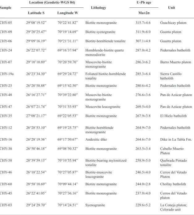
In the High Andes a U-Pb age of 291.5±4.0 Ma was obtained for an andesitic tuff intercalated in the upper section of El Mono Beds (sensu Mercado, 1982; Mpodozis et al., 2012), which is a mostly alluvial and lacustrine sedimentary succession, TABLE 4. SUMMARY OF NEW SHRIMP ZIRCON U-Pb CONCORDIA AGES FOR INTRUSIVE ROCKS.
Sample
Location (Geodetic-WGS 84)
Lithology
U-Pb age
Unit
Latitude S Longitude W Ma±2σ
CHY-05 29°08’19.52” 70°22’41.82” Biotite monzogranite 315.7±4.6 Guachicay pluton
CHY-09 29°20’25.47” 70°19’14.69” Biotite syenogranite 311.9±6.0 Guanta pluton
CHY-06 29°09’16.19” 70°21’31.11” Biotite-hornblende tonalite 307.1±4.8 Guanta pluton
CHY-24 26°22’07.72” 69°16’37.94” Hornblende-biotite quartz
monzodiorite 287.0±4.2 Pedernales batholith CHY-07 29°10’10.89” 70°20’59.70” Muscovite-biotite
monzogranite 286.3±6.2 Burro Muerto pluton CHY-19a 26°23’34.30” 69°29’24.72” Foliated biotite-hornblende
tonalite 285.3±6.4 Sierra Castillo batholith CHY-23 26°20’58.88” 69°15’42.50” Biotite monzogranite 280.6±4.2 Pedernales batholith
CHY-48 26°16’27.71” 70°39’22.80” Muscovite-biotite
monzogranite 276.6±3.6 Pan de Azúcar pluton CHY-47 26°07’21.74” 70°31’53.93” Muscovite leucogranite 269.5±4.0 Pan de Azúcar pluton
CHY-35 27°08’21.17” 69°22’05.53” Biotite monzogranite 267.9±3.8 El Hielo batholith
CHY-12 26°28’53.10” 69°19’25.75” Biotite-hornblende
monzogranite 264.9±7.0 Pedernales batholith CHY-16 26°28’19.36” 69°17’50.67” Andesitic dike 264.6±7.0 Dike in La Tabla Fm.
CHY-38 26°50’46.18” 69°08’50.32” Biotite monzogranite 263.5±3.4 Caballo Muerto Pluton CHY-58 28°39’59.13” 70°10’55.94” Biotite-bearing mylonitized
tonalite 258.9±5.0 Quebrada Pintado tonalite CHY-46 26°18’22.54” 70°27’05.87” Biotite-muscovite
leucogranite 246.5±4.0 Cerros del Vetado Pluton CHY-60 28°58’18.69” 70°09’44.14” Biotite monzogranite 244.0±2.8 Chollay batholith
CHY-45 26°22’41.05” 70°27’36.16” Biotite monzogranite 237.0±4.0 Cerros del Vetado pluton
ca. 1,000 m thick, formed of sandstone and conglom-erate strata that unconformably overlie Devonian to Early Carboniferous sandstones of the Chinches Formation in the High Andes at ~27°S (Fig. 4) and underlies in apparent conformity Jurassic marine strata (Mercado, 1982; Mpodozis et al., 2012). This sedimentary-volcanic succession was previously attributed to the Late Triassic based on fossil flora and conchostracans (Davidson et al., 1978; Mer-cado, 1982; Suárez and Bell, 1991; Blanco, 1994; Cornejo et al., 1998; Gallego and Covacevich, 1998; Mpodozis et al., 2012).
U-Pb dates ranging from 282.0±11.4 to 270.4±4.6 Ma were obtained for 4 samples of banded rhyolites and rhyolitic tuff from the type locality of La Tabla Formation, (sensu García, 1967), in the eastern part of the Domeyko Cor-dillera and southwest of the Pedernales Salar in the Atacama Region (26°30’S; Fig. 4). One sample (CHY-14; Table 3) returned a bimodal age distribution with an older population at 311.3±8.2 Ma and a younger one at 282.0±11.4; the analytic spots on the cathode luminescence images of the zircons indicate that the older age population corresponds to inherited zircon cores, while the younger ages to zircon rims, thus the younger population corresponding to the actual crystallization age of the dated rock. The La Tabla Formation is an 800 m thick succes-sion formed of rhyolites, rhyolitic tuffs, breccias, and basaltic intercalations (without exposed base) which originally was thought to be Early Triassic in age (García, 1967), but later assigned to the Late Paleozoic by Tomlinson et al. (1999), based on K-Ar ages of intrusions that crosscut the unit. The volcanic rocks of La Tabla Formation are crosscut by granitoids of the Pedernales Batholith and andesitic dikes that yielded U-Pb ages from 287.0±4.2 to 264.6±7.0 Ma (Table 4). According to the new U-Pb dates it represent Permian volcanism, which is a bit younger but overlapping with the U-Pb ages from 309.9±2.2 to 282±2 Ma published for rocks assigned to the La Tabla Formation along the Domeyko Cordillera north of 25°30’S latitude (Table 1). In addition, a U-Pb age of 262.0±2.8 was obtained for a sample of fluidal rhyolite farther south (26°49’S; Table 3), mapped as La Tabla Formation by Cornejo et al. (1998) that is part of a succession crosscut by granite of the Caballo Muerto Pluton, which yielded a U-Pb age of 263.5±3.4 Ma (Table 4).
A U-Pb age of 270.3±4.2 Ma was obtained for a basal dacite horizon and additional U-Pb ages of 269.9±4.0 and 266.1±4.4 Ma were obtained for dacitic tuff and rhyolitic ignimbrite of the Pantanoso Formation (Mercado, 1982; Mpodozis et al., 2012), at its type locality (Table 3; Fig. 4). The Pantanoso Formation is crosscut by granite of the El Hielo batholith that yielded a U-Pb age of 267.9±3.8 Ma (Table 4). The Pantanoso Formation is a 1,000 thick succession of rhyolitic and dacitic volcanic rocks and minor conglomerate and volcanic sandstone intercalations exposed in the High Andes at 27°28’S latitude, and according to the new U-Pb data it rep-resent Mid-Permian volcanism. It unconformably overlies mainly Devonian to Early Carboniferous sandstones of the Chinches Formation (Mercado, 1982; Bell, 1985), but also a local lens of folded sandstone and conglomerate beds up to 200 m thick of the Elba Beds, which were ascribed to the Carboniferous-Permian by Mercado (1982).
U-Pb zircon ages of 255.9±6.2 and 242.7±5.8 Ma (Table 3) were obtained for samples of ignimbrite and rhyolite from the Cas Formation (sensu Ramírez and Gardeweg, 1982), which is a succession of about 300 m thick (without exposed base), outcropping immediately east of the Peine town, in the eastern part of the Antofagasta Region (Fig. 3). The new U-Pb ages are consistent with the mean weighted U-Pb age of 248±3 based on 4 separate determi-nations published by Breitkreuz and van Schmus (1996) and indicate that the rhyolitic rocks of the Cas Formation represent a Late Permian to Early Triassic felsic volcanism.
A sample of basaltic tuff from the basal meters of the mostly basaltic-andesitic La Totora Formation in the homonymous creek in the High Andes of the Vallenar region (28º42’; Fig. 4) yielded a U-Pb age of 249.7±3.8 Ma. The dated sample (CHY-56) actually returned a bimodal age distribution with an older population at 323.6±5.8 Ma; the analytic spots on the cathode luminescence images of the zircons indicate that the older age population corresponds to inherited zircon cores, while the younger ages to zircon rims, thus the younger population corresponding to the actual crystallization age of the dated rock. Another sample of basalt of the same succession in the Totora creek yielded an U-Pb age of 221.0±2.6 Ma; these ages are coherent with the U-Pb ages from 217.9±1.4 to 210.4±2.9 Ma published by Salazar
unit unconformably overlies a mylonitized tonalite of the Quebrada Pintado intrusive unit (sensu Salazar
et al., 2013) for which we obtained a U-Pb age of 258.9±5.0 Ma (Table 4), and conformably underlies fossiliferous, Mid-Late Jurassic (Sinemurian) marine limestones (Reutter, 1974; Nasi et al., 1990; Salazar
et al., 2013); stratigraphic position that is consistent with the new U-Pb data. In addition, strata of the western belt of La Totora Formation are in part conformably overlying the 4,000 m thick, mostly clastic-sedimentary Mid-Late Triassic San Felix Formation to the southwest (Salazar et al., 2013).
U-Pb ages of 232.1±4.6, 224.0±3.4, and 221.6±3.4 were obtained for samples of banded rhyolites and rhyolitic tuffs from the Los Tilos sequence of the Pastos Blancos Group (sensu Martin et al., 1999), exposed in the Potrerillos river valley in the High Andes, 20 km west of the divide (29°30’S; Fig. 4); this new U-Pb data confirms the Late Triassic age of the Los Tilos volcanic sequence of the Pastos Blancos Group, which unconformably overlies the Permian silicic volcanics of the Guanaco Sonso sequence as defined by Martin et al. (1999).
A U-Pb age of 154.3±3.8 Ma was obtained for andesite that is part of a succession outcropping in the west flank of the El Carmen river valley (29°17’S; Fig. 4). This intermediate volcanic unit was origi-nally mapped as part of the Late Paleozoic-Triassic Pastos Blancos Formation (with a question mark) by Nasi et al. (1990). Actually, the new U-Pb age shows that these andesitic rocks are Late Jurassic in age, being equivalent in age and lithology to the Picudo Formation (Reutter, 1974; Moscoso et al., 2010) exposed in the El Tránsito river valley and to the Lagunillas Formation, which has been recogni-zed farther north between 27°30’ and 28°30´S in the High Andes of the Atacama Region and these represent Late Jurassic back-arc volcanism (Iriarte
et al., 1999; Oliveros et al., 2011).
5.2. Intrusive rocks
The new zircon U-Pb ages for Late Paleozoic intrusive rocks range from 315.7±4.6 to 229.6±5.2 Ma (Table 4), well within the 328 to 206 Ma interval of the compiled U-Pb dates (Table 2).
Granitoids exposed along the Domeyko Cordillera and its southern continuation in the Frontal Cordillera yielded U-Pb ages from 287 to 263 Ma (Table 4; Fig. 4), representing Permian granitic plutonism, these
include: a U-Pb age of 285.3±6.4 Ma for a foliated tonalite that is part of the Sierra Castillo batholith (sensu Tomlinson et al., 1999; Fig. 4); a U-Pb age of 287.0±4.2 Ma for a hornblende-biotite monzodiorite and U-Pb ages of 280.6±4.2, and 264.9±7.0 Ma for biotite-hornblende, monzogranite plutons of the Pedernales batholiths (sensu Tomlinson et al., 1999; Fig. 4); a U-Pb age of 263.5±3.4 Ma for monzogranite of the Caballo Muerto pluton (sensu Cornejo et al., 1998); and a U-Pb age of 267.9±3.8 Ma for leuco-cratic, monzogranite of the El Hielo batholith (sensu
Mercado, 1982; Bell, 1985; Mpodozis et al., 2012) in the High Andes of the Atacama Region (Fig. 4).
A U-Pb age of 244.0±2.8 Ma was obtained for a coarse-grained monzogranite of the Chollay Batholith (Fig. 4), which is consistent with U-Pb ages from 247.7±3.4 to 240.3±1.7 Ma that have recently been reported for the same batholith (Coloma et al., 2012; Salazar et al., 2013; Álvarez et al., 2013; Hervé et al., 2014). These U-Pb ages confirm the Mid-Triassic age ascribed to the granitic Chollay batholith by Nasi
et al. (1985) and Martin et al. (1999).
The dating of plutons of the northern part of the composite Elqui-Limarí Batholith in the Frontal Cordillera of the Atacama Region (Fig. 4) have yield U-Pb ages from 315.7±4.6 to 229.6±5.2 Ma (Table 4). These are consistent with the 330 to 215 U-Pb in-terval of recently published U-Pb ages for the same batholith (e.g., Pineda and Calderón, 2008; Salazar et al., 2009, 2013; Coloma et al., 2012, Álvarez et al., 2013; Hervé et al., 2014). We have obtained a U-Pb age of 315.7±4.6 Ma for a coarse-grained, biotite monzogranite from the Guachicay pluton (sensu
of the La Coneja pluton (sensu Nasi et al., 1985) that corresponds to the Colorado intrusive unit of Nasi
et al. (1985, 1990).
A U-Pb zircon age of 258.9±5.0 Ma (Late Per-mian) was obtained for mylonitized tonalite of the Quebrada Pintado tonalitic unit of Salazar et al. (2013) in the La Totora creek (28°40’S; Fig 4). The mylonites at La Totora creek show a N35°E/75°E foliation and centimetric to decimetric white, felsic bands alternating with dark gray, biotitic bands. This mylonitized intrusion unconformably underlies the Mid-Late Triassic volcanic rocks of La Totora Formation.
Along the Pacific coast north of Chañaral, about 120 km west of the High Andes, U-Pb ages of 276.6±3.6 and 264.6±7.0 Ma were obtained for biotite-muscovite, monzogranite of the Pan de Azúcar pluton (sensu Mercado, 1980; Godoy and Lara, 1998), while two U-Pb ages of 246.5±4.0 and 237.0±4.0 were obtained for coarse-grained, muscovite-biotite monzogranite of the Cerros del Vetado pluton of the Coastal Cordillera immediately east of Chañaral (Fig. 4).
6. Discussion
The U-Pb data provide evidence for the onset of volcanism at ~325 Ma (by the end of the Missisip-pian), which is approximately coeval with the onset of granitic plutonism at ~328 Ma (Tables 2 and 3), confirming a previous conclusion of Hervé et al. (2014). This marks reestablishment of magmatism during the Carboniferous after a gap in igneous acti-vity during the Devonian in northern Chile and Perú (e.g., Charrier et al., 2007; Boekhout et al., 2013).
6.1. Volcanic rocks
The oldest rhyolitic rocks (325 to 292 Ma; Table 1 and 3) are present within the current Intermediate Depression and the western foothills of the High Andes of northern Chile (Figs. 3 and 4). Part of this initial volcanism developed within a shallow marine platform represented by carbonate strata with Late Permian marine fossils that are overlying and partly interfingered with the dated rhyolitic rocks (Juan de Morales Formation in the Tarapacá Region; Galli, 1956, 1968; Díaz-Martínez et al., 2000; Cerro del Árbol Formation in Antofagasta Region; Marinovic
et al., 1995; Marinovic, 2007; and Quebrada de Las
Represas Beds in the Atacama Region; Iriarte et al., 1996). While, the rhyolitic succession exposed in the El Tránsito river valley includes conglomerates, sandstones and andesites (Cerro Bayo Formation; Salazar, 2012; Salazar et al., 2013).
The mainly felsic volcanic rocks widely exposed along the Domeyko Cordillera and Precordillera of northern Chile north of 25°30’S latitude have yielded U-Pb ages from 310 to 282 Ma Tables 1 and 3), thus represent a Late Carboniferous to Early Permian volcanism that is older than the Choiyoi succession of the San Rafael Block in western Argentina for which U-Pb ages from 281 to 251 Ma have been published (Rocha-Campos et al., 2011). Actually, the Chilean Carboniferous to Early Permian volcanic rocks are chronologically equivalent to sedimentary successions with submarine volcanic deposits that are present farther east in Argentina (Azcuy et al., 1999; López-Gamundí, 2006; Koukharsky et al., 2009; Gulbranson et al., 2010). Therefore, when the Carboniferous to Early Permian magmatism was active along the current Domeyko Cordillera and Precordillera northwards, in Argentina farther east developed contemporary marine basins; this situation has been interpreted as a magmatic arc and back-arc basins by Gulbranson et al. (2010).
dating. Therefore, El Mono Beds could be equivalent to a sedimentary unit with Late Carboniferous flora and marine fossils exposed near the watershed of the Andes at ~29°S latitude (Las Placetas Formation; Reutter, 1974; Nasi et al., 1990); these sedimentary deposits probably represent the westernmost part of sedimentary basins developed mainly farther east in Argentina during the Carboniferous to Early Permian (Azcuy et al., 1999; López-Gamundí, 2006; Koukharsky et al., 2009; Gulbranson et al., 2010).
Rhyolitic volcanism with andesitic and basaltic intercalations persisted during the Permian along the current Domeyko Cordillera and the Chilean Frontal Cordillera (High Andes) as the volcanic rocks exposed south of 25°30’S latitude have yiel-ded U-Pb ages from 282 to 262 Ma (Figs. 3 and 4). These are represented by the La Tabla, and Pantanoso Formations, and the Guanaco Sonso Sequence of the Pastos Blancos Group (Mercado, 1982; Cornejo et al., 1993, 1998, 2009; Martin et al., 1999; Tomlinson
et al., 1999; Mpodozis et al., 2012) and their U-Pb ages fall well within the 281 to 251 Ma time span of U-Pb ages published by Rocha-Campos et al. (2011) for the Choiyoi Succession of the San Rafael Block in western Argentina.
The U-Pb age of 270.3±4.6 Ma for the basal unit of the Pantanoso Formation (Table 3) indicates the onset of volcanic accumulation in the current High Andes at ~27°S latitude unconformably on top of deformed Devonian to Early Carboniferous sedimentary rocks (Chinches Formation; Mercado, 1982; Bell, 1985), but also over folded sandstone and conglomerate beds ascribed to the Carboniferous-Permian (Elba Beds; Mercado, 1982). Thus, according to the new U-Pb data the accumulation of the volcanic rocks of the Pantanoso Formation at its type locality occurred at least 20 My later than the rhyolitic succession that is exposed 47 km to the west in the Paipote valley, which in previous works has also been assigned to the Pantanoso Formation (Iriarte et al., 1996).
Late Permian to Early Triassic rhyolitic volcanism is represented by the Cas Formation that yielded U-Pb ages from 256 to 243 Ma (Fig. 3; Tables 1 and 3) and is exposed in the easternmost part of Chile (68°W), along the eastern side of the Salar de Ata-cama salt flat in the Antofagasta Region (Ramírez and Gardeweg, 1982; Breitkreuz and van Schmus, 1996). The rhyolitic rocks of the Cas Formation at its type locality are significantly younger than the Early Permian rhyolitic rocks exposed some 90 km
to the west along the Domeyko Cordillera (e.g., Sierra del Jardín Rhyolites; Marinovic, 2007), even though the latter were mapped as the same formation by Mpodozis et al. (1993).
The occurrence of Mid-Permian to Early Triassic volcanic rocks eastward from the Carboniferous to Early Permian volcanic rocks in Chile is interpreted as a Mid-Permian to Early Triassic expansion and/ or eastward migration of the volcanic front, which is consistent with evidences of expansion of the volcanic activity farther east in Argentina at that time (e.g., Ramos and Folguera, 2009; Ramos, 2009).
Middle Triassic to Early Jurassic volcanic rocks yiel-ded zircon U-Pb ages from 249.7±3.8 to 194.0±9.2 Ma, their outcrops are more discontinuous (patchy) and dispersed compared to the older volcanic rocks, and are separated from them by erosional surfaces. During this period andesitic to basaltic volcanism coexisted with felsic volcanism (bimodal volcanism), and was synchronous with rift-related, continental and/or marine sedimentary deposits in northern Chile (e.g., Suárez and Bell, 1992; Bell and Suarez, 1994). Middle to Upper Triassic strata show strong facies changes along the longitudinal axis of the High Andes, for example according to the U-Pb data the mostly basaltic-andesitic La Totora Formation (250-210 Ma) overlaps in age with the upper part of the mainly clastic, sedimentary San Félix Formation (223-212 Ma), but also with rhyolites of Los Tilos Sequence (232-221 Ma), within less than 100 km in the Atacama Region. These striking north-south facies changes probably reflect the main northwest orientation of extensional basins that developed in the Mid-Late Triassic in Chile and Argentina (Charrier, 1979; Chong and Von Hillebrandt, 1985; Uliana et al., 1989; Ramos and Kay, 1991; Jenchen and Rosenfeld, 2002; Charrier et al., 2007; Barredo
et al., 2012).
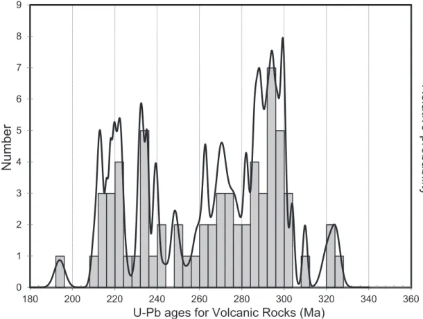
for sampling, the statistical analysis of the U-Pb data may signify that major volcanic episodes extended from the Late Carboniferous to Late Permian and then from Mid- to Late Triassic, but were preceded by a mid-Carboniferous volcanic episode and followed by an Early Jurassic one.
6.2 Intrusive rocks
U-Pb data for plutonic rocks show that earliest intrusions crystallized from 328.1±2.8 to 311.9±6.0 Ma, including coarse-grained, biotite-muscovite granite to granodiorite (S-type) and biotite monzogranite and biotite-hornblende granodiorite plutons (I-type). From 308.5±2.2 to 290±2 Ma rhyolitic and granitic porphyries and equigranular monzogranite plutons crystallized and biotite-muscovite granitic and gra-nodioritic plutons, and hornblende-diorite tonalitic to dioritic plutons were emplaced. Furthermore, 33 compiled and 9 new U-Pb zircon ages, which altogether range from 298.9±2.6 to 252.5±1.8 Ma
attest that plutonism was active during the whole Permian in northern Chile, when there was a strong predominance of coarse-grained monzogranite plu-tons, both equigranular and porphyritic, followed by coarse-grained biotite-hornblende tonalites, and only minor monzonite, diorite and gabbro intru-sions; two-mica (S-type) granites, granodiorites, and tonalites also intruded during this time span. Most of the Permian plutons are exposed along the High Andes and Domeyko Cordillera, but Permian granites with U-Pb ages of 277-270 Ma are also present some 120 km west in the Pacific coast (Pan de Azúcar pluton, Fig 4).
Triassic plutonism is represented by granitic por-phyries, biotite- and two-mica granites, granodiorites, and brick-red syenogranite intrusions with U-Pb ages that range from 247.0±3.1 to 215.6±1.9 Ma. Some of these intrusions are of large volume, as most of the Chollay and Montosa granitic batholiths are formed of Triassic medium to coarse-grained monzogranites for which U-Pb ages of 245.0±3.1
0 1 2 3 4 5 6 7 8 9
180 200 220 240 260 280 300 320 340 360
Relati
ve
pro
babili
ty
Nu
m
ber
U-Pb ages for Volcanic Rocks (Ma)
and 240.3±1.7 Ma have been reported (Coloma et al., 2012; Hervé et al., 2014) and we obtained a U-Pb age of 244.0±2.8 Ma. Triassic granitic plutons are also present in the current Coastal Cordillera as Cerros del Vetado pluton yielded U-Pb ages of 247-237 Ma (Fig. 4).
The U-Pb data now available evidence that muscovite-bearing intrusive, with S-type granite characteristics, were not confined to a single discrete Permian magmatic episode as previously thought, but crystallized within the entire time span from Late Carboniferous to Late Triassic and synchronically with biotite- and hornblende-bearing intrusions with petrographic characteristics of I-type granitoids; this is in agreement with a similar conclusion based on U-Pb data for the Elqui-Limarí Batholith (Hervé et al., 2014). Actually, the synchronic emplacement of I- and S-Type granitoids was already noted and sustained by chemical data by Marinovic et al. (1995) in the Domeyko Cordillera, though it was attributed to a local phenomenon related to a hypothetical longitu-dinal segmentation of the Late Paleozoic to Triassic plutonism, rather than to a regional characteristic.
The new U-Pb data from 277 to 237 Ma (Table 4) confirm that Permian and Mid-Triassic granitic magmatism is also exposed in the current coastal area, which combined with previously published geochronological data suggests a protracted plutonism extending from 322 to 217 Ma along the Coastal Cordillera of northern Chile from 21° to 33°S (Maksaev and Marinovic, 1980; Skarmeta and Marinovic, 1981; Berg et al., 1983; Shibata et al., 1984; Berg and Baumann, 1985). However, there appears to be a difference with the Coastal Batholith exposed to the south between 33° to 38°S, which has yielded eight 320 to 300 Ma (Pennsylvanian) U-Pb zircon ages (Deckart et al., 2014), but to date there are no Permian and Early Triassic granitoids intruded in the main body of this Coastal Batholith of central-southern Chile, and only some small Late Triassic-Early Jurassic stocks of calc-alkaline to transitional A-type affinities, with U-Pb zircon ages from 225 to 197 Ma that are emplaced into its metamorphic envelope (Vásquez et al., 2011; Hervé et al., 2014).
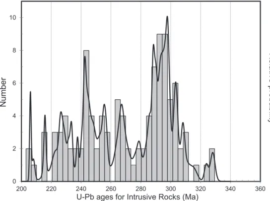
A probability density plot and stacked histogram of all U-Pb ages for intrusive rocks (Fig. 6) shows
0 2 4 6 8 10
200 220 240 260 280 300 320 340 360
Relati
ve
pro
babili
ty
Nu
m
ber
U-Pb ages for Intrusive Rocks (Ma)
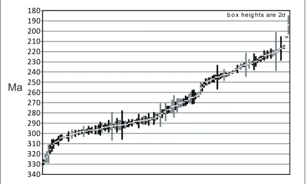
that plutonic activity extended for at least 120 My from about 328 to 206 Ma (Late Missisipian to Late Triassic) with a largest concentration of U-Pb dates between 310 and 280 Ma, followed by another significant concentration of U-Pb dates from 255 to 205 Ma, and other less prominent U-Pb age concen-trations from 330 to 310 Ma and 280 to 260 Ma. This statistical analysis of the U-Pb data may signify that major intrusive episodes took place from the Late Carboniferous to Early Permian and from the Late Permian to Late Triassic, but also there were mid-Carboniferous and mid-Permian intrusive episodes. The inferred plutonic episodes are fundamentally coincident with the major episodes of volcanism inferred from the statistical analysis of U-Pb data (Figs. 5 and 6). A sequential plot of the U-Pb ages (Fig. 7) shows that there are no apparent periods when the volcanism or plutonism prevailed, but both developed simultaneously from the Carboniferous to the Early Jurassic. A probability density plot and stacked histogram of all U-Pb ages for igneous rocks (Fig. 8) show the largest concentration of dates from 310 to 260 Ma and from 255 to 205 Ma, which are
interpreted as the major magmatic episodes developed during from the Late Carboniferous to Mid-Permian and from Late Permian to Late Triassic. Other less prominent U-Pb age concentrations reveal a mid-Carboniferous episode (330 to 320 Ma) and an Early Jurassic episode (200-190 Ma).
The magmatic episodes of the Chilean Andes fall well within the 336 to 230 Ma interval of published U-Pb geochronological data for igneous rocks of Argentina (Pankhurst, 2006; Gulbranson et al., 2010; Rocha-Campos et al., 2011; Barredo et al., 2012; Suárez et al., 2012; Gregori and Benedini, 2013), but also with the interval from 342 to 190 of U-Pb data from the Andes of Perú, Ecuador and Colombia (Restrepo et al., 1991; Noble et al., 1997; Ordoñez and Pimentel, 2002; Vinasco et al., 2006; Chew et al., 2007; Ibáñez-Mejía et al., 2008; Cardona et al., 2008, 2009; Mišković et al., 2009, Mišković and Shaltegger, 2009; Witt et al., 2013; Boekhout et al., 2013). Therefore, despite local particularities, there was a rather consistent evolution in time of the magmatism along the southwestern, paleo-Pacific border of Gondwana.
180 190 200 210 220 230 240 250 260 270 280 290 300 310 320 330 340
Ma
b o x heig hts are 2σ
7. Conclusions
U-Pb zircon geochronological data provide record of about 130 Ma of igneous activity in the Andes of northern Chile that extended episodica-lly from the latest Early Carboniferous to Early Jurassic (328-194 Ma). The overall U-Pb data show that volcanism and plutonism were essentially syn-chronous and inferred major episodes of igneous activity developed during the Late Carboniferous to Permian (310 to 260 Ma) and from Late Permian to Late Triassic (255-205 Ma), with less prominent episodes in the mid-Carboniferous (330 to 320 Ma), and Early Jurassic (200-190 Ma). Thus, from the Carboniferous to the Early Triassic dominantly silicic magmatism developed along the Chilean segment of the southwestern border of Gondwana supercontinent. Further magmatism developed during the Mid-Late Triassic (250-194 Ma) was bimodal and synchronous with rift-related, continental and/
or marine sedimentary strata related to the early stages of break-up of Gondwana.
Most of the siliceous volcanic rocks of the Pre-cordillera and Domeyko Cordillera of northern Chile (21°30’ to 25°30’S) are older than the silicic rocks assigned to the Choiyoi succession in Argentina, being instead equivalent in age to Carboniferous to Early Permian marine sedimentary sequences present in the eastern Argentinean foreland. On the other hand, silicic volcanic successions ex-posed in the easternmost part of northern Chile are equivalent in age to the Choiyoi succession of the San Rafael Block of Argentina. An eastward expansion or migration during the Mid-Permian to Early Triassic is inferred by the age difference between older western rhyolitic deposits and younger eastern rhyolitic volcanic that originally were supposed to be of the same age; interpretation that is consistent with expansion of the volcanism at that time in Argentina.
0 2 4 6 8 10 12 14 16 18 20
180 200 220 240 260 280 300 320 340 360