Crustal faults in the Chilean Andes : seismotectonic constraints from a combined geological and geophysical approach
127
0
0
Texto completo
(2) PONTIFICIA UNIVERSIDAD CATÓLICA DE CHILE SCHOOL OF ENGfNEEERING. CRUSTAL FAULTS IN THE CHILEAN ANDES: SEISMOTECTONIC CONSTRAINTS FROM A COMBINED GEOLOGICAL AND GEOPHYSICAL APPROACH.. ISABEL VERÓNICA SANTIBÁÑEZ BORié Members of the Committee JOSÉ CEMBRANO GONZALO YÁÑEZ. RAFAEL RIDDEL CARLOS COSTA. ~. _ ," --m'. GUSTAVO LAGOS. Thesis submitted to the Office of Graduate Studies in partial fulfillment of the requirements for the Degree of Doctor in Engineering Sciences Santiago de Chile, September-2019.
(3) The human understanding is no dry light, but receives an infusion from the will and affections; whence proceed sciences which may be called “sciences as one would.” For what a man had rather were true he more readily believes. Therefore he rejects difficult things from impatience of research; sober things, because they narrow hope; the deeper things of nature, from superstition; the light of experience, from arrogance and pride, lest his mind should seem to be occupied with things mean and transitory; things not commonly believed, out of deference to the opinion of the vulgar. Numberless in short are the ways, and sometimes imperceptible, in which the affections colour and infect the understanding. Francis Bacon, Novum Organon (1620). A mis amados hijos Seba y Emi, fuentes inagotables de inspiración y cambio. i.
(4) ACKNOWLEDGEMENTS Esta Tesis es el resultado de un largo trabajo desarrollado gracias al apoyo de muchas personas, amigos y científicos, y diversos proyectos e instituciones. A todos ellos les debo agradecimiento incalculable por confiar en mí y en que este propósito y deseo fuese logrado. La Comisión Nacional de Ciencia y Tecnología (CONICYT) a través de la Beca de Doctorado Nacional, el Proyecto FONDECYT Regular 1140846, el Proyecto FONDEF +Andes D10I1027, el Proyecto FONDAP CEGA 15090013, y el Proyecto FONDAP CIGIDEN 15110017 financiaron directa e indirectamente esta Tesis, además de ser la plataforma para reunir a destacados geólogos e ingenieros. El proyecto SARA-GEM fue un pilar fundamental en el desarrollo de la metodología y la posibilidad de aprender de científicos relevantes a nivel mundial en la temática. El científico que me apoyó y entusiasmó a seguir este doctorado, fue mi profesor supervisor José Cembrano. Su pasión por la enseñanza de la ciencia y sus desafíos éticos, han sido una sorpresa y un tremendo regalo de este camino. Esta aventura comenzó a poco de que formaran el grupo de Geociencias de la Pontificia Universidad Católica junto a los profesores Gloria Arancibia y Gonzalo Yáñez, al que se integraron mi compañera Pamela Pérez-Flores y la invaluable Mariel Castillo. A todos ellos mis más profundas gracias, por su ayuda, paciencia y amistad.. Mis agradecimientos también al resto que fue. incorporándose al grupo de geociencias y nuestra especial dinámica: Rodrigo, Tiaren, Nico, Gerd, Rocío, Gert, Tomás, Pablo I., Ashley, Elias, Álvaro, Javi. Así también los “de afuera”: Pablo S., Joaquín CA, Ian, Angelo, Camilo, José G. Numerosos profesores y sus conocimientos están reflejados en este documento y merecen un especial reconocimiento: Carlos Costa por considerarme en el proyecto SARA-GEM y apoyarme en el desarrollo del mismo y mi Tesis. A Gabriel González por incluirme en su proyecto y por los numerosos terrenos en el norte y sus enseñanzas. A Rafael Riddell por incorporarnos al panel de trabajo de Espectro de Diseño del IChC. Constantino Mpodozis, Carlos Marquardt, Felipe Aron, Andrés Veloso y Jorge Crempien ii.
(5) de la PUC y Felipe Leyton, R. Allmendinger, Pablo Salazar, han tenido recomendaciones y opiniones sumamente valiosas. A todos los del Departamento de Ingeniería Estructural y Geotecnia, y en especial a Josefina, Jenny, Carlitos (QEPD), Luis y Priscilla. A las señoras del café y Marina. A mis amigos: Marcela, Fernanda, Luis A., Sandra, Robin, Chigua, Igor, y a las chicas-hidro; Clau, Caro, Gi, Ire, Su, Kerstin, Pili, Vivi y Virgi, por su apoyo especial. Y finalmente a mi familia. A mis abuelos Luis, Berta y Magdalena, que me regalonearon y estimularon la curiosidad por la ciencia y la tierra con sus historias y paseos. A mis padres Marcelo y María Angélica, por enseñarme el valor de la educación y de ser una persona involucrada socialmente, y por permitirme soñar e imaginar que todo es posible. A mis hermanos Pablo, Titi, Mona, Mari, Javi, Dani y Pipe, por su mantenerme siempre preparada para los altibajos de la vida y enseñarme que nada es tan grave que no nos podamos reír. Y muchísimas gracias a mis hijos por comprender como es su madre y enseñarme que siempre se puede aprender.. iii.
(6) CONTENTS Page ACKNOWLEDGEMENTS ......................................................................................... ii TABLE INDEX .......................................................................................................... vi FIGURE INDEX ......................................................................................................... vi ABSTRACT .............................................................................................................. viii RESUMEN................................................................................................................... x 1. INTRODUCTION .............................................................................................. 1 1.1 Organization of this Thesis ........................................................................ 1 1.2 Theoretical Background ............................................................................. 2 1.3 Seismogenic Potential of Crustal Faults .................................................. 12 1.4 Research Problem..................................................................................... 13 1.5 Hypothesis ................................................................................................ 14 1.6 Objectives ................................................................................................. 14 1.7 Methodology ............................................................................................ 15. 2. CRUSTAL FAULTS IN THE CHILEAN ANDES: GEOLOGICAL CONSTRAINTS AND SEISMIC POTENTIAL ............................................. 16 2.1 Introduction .............................................................................................. 16 2.2 Geological Framework of Crustal Faults of the Chilean Andes .............. 18 2.3 Use of Geological and Paleoseismological Data in the Analysis of Seismic Hazard: Issues and Challenges ................................................................. 24 2.4 Historical and Instrumentally Recorded Crustal Earthquakes ................. 26 2.4.1 2001 Aroma Earthquake, Inner Forearc Domain .......................... 30 iv.
(7) 2.4.2 1958 Las Melosas Earthquake, Volcanic Arc Domain .................. 30 2.4.3 2004 Teno Earthquake, Volcanic Arc Domain .............................. 31 2.4.4 2007 Aysén Earthquakes, Volcanic Arc Domain .......................... 31 2.4.5 2010 Pichilemu Earthquakes, Outer Forearc Domain ................... 32 2.5 Neotectonic Crustal Faults ....................................................................... 33 2.5.1 Outer Forearc Domain ................................................................... 36 2.5.2 Inner Forearc Domain .................................................................... 42 2.5.3 Volcanic Arc Domain .................................................................... 45 2.5.4 Other Crustal Faults ....................................................................... 47 2.6 Discussion ................................................................................................ 50 2.6.1 Fault Parameters for Longitudinal Domains.................................. 51 2.6.2 Estimated Earthquakes ................................................................... 55 2.6.3 Assessment of Parameter Uncertainties ......................................... 55 2.6.4 Fault Activation Mechanisms and Hazard Assessment ................. 59 2.7 Conclusions .............................................................................................. 61 3. GEOPHYSICAL SIGNALS OF NEOTECTONIC ACTIVITY ON THE AEROPUERTO FAULT: A CASE STUDY IN THE ATACAMA REGION, NORTHERN CHILE ........................................................................................ 63 3.1 Introduction .............................................................................................. 63 3.2 Local Geology and Tectonics................................................................... 65 3.3 Geophysical Methods and Data ............................................................... 72 3.3.1 Gravity Survey ............................................................................... 73 3.3.2 Magnetic Survey ............................................................................ 73 3.3.3 Seismic Survey .............................................................................. 73 3.3.4 Electrical Survey (ERT) ................................................................ 74 v.
(8) 3.3.5 Transient Electromagnetic (TEM) Survey..................................... 74 3.4 Results and Discussion............................................................................. 76 3.5 Conclusions .............................................................................................. 85 3.6 Acknowledgements .................................................................................. 86 4. CONCLUSIONS .............................................................................................. 87. 5. REFERENCES ................................................................................................. 92. TABLE INDEX Page Table 1-1: Evidence of neotectonic deformation in the Chilean forearc. .......................... 8 Table 2-1: Latitudinal tectonic segmentation of the Chilean Andes. ............................... 23 Table 2-2: Selected instrumentally recorded crustal earthquakes in Chile. ..................... 29 Table 2-3: Seismogenic parameters of crustal faults in Chile.......................................... 57 Table 3-1: Magnetic susceptibility and density of the analyzed rocks and sediments..... 77. FIGURE INDEX Page Figure 1-1: General context of the Nazca–South American subduction zone. .................. 3 Figure 1-2: Schematic depiction of the subduction seismic cycle and forearc deformation. ............................................................................................................................................ 4 Figure 2-1: Morphotectonic context and segmentation of the Chilean Andes. ............... 21 Figure 2-2: Map showing the locations of 372 crustal earthquakes recorded along the Chilean Andes between January 1976 and April 2015. ................................................... 28 vi.
(9) Figure 2-3: Compilation of crustal faults in the Chilean Andes which show evidence of neotectonic activity. ......................................................................................................... 34 Figure 2-4: Schematic W-E cross-section of the subduction zone in Central Chile (~34ºS) with selected earthquakes (between 33.5º and 34.5ºS). ................................................... 53 Figure 3-1: Tectonic setting of the forearc of Northern Chile. ........................................ 67 Figure 3-2: Crustal Faults at the latitude of the Mejillones Peninsula (23.5ºS). .............. 68 Figure 3-3: Local geological map of the study area. ........................................................ 70 Figure 3-4: Panoramic view of the Aeropuerto Fault. ..................................................... 71 Figure 3-5: Details of the geophysical fieldwork performed in this study. ..................... 75 Figure 3-6: Results of the passive geophysical surveys. .................................................. 78 Figure 3-7: Results of the active geophysical surveys ..................................................... 81 Figure 3-8: Results of the TEM survey for (a) profile L10. (b) profile L18 ................... 82 Figure 3-9: Results and integration for profile L10. ....................................................... 83 Figure 3-10: Results and integration for profile L18. ..................................................... 84 Figure 4-1: E-W reverse faults in the Outer Forearc domain (e.g., Bajo Molle Fault). .. 89 Figure 4-2: N-S normal faults in the Outer Forearc domain (e.g., the Atacama Fault System)............................................................................................................................. 89 Figure 4-3: A trench-oblique normal fault in the Outer Forearc domain (e.g., Pichilemu Fault). ............................................................................................................................... 90 Figure 4-4: A trench-parallel strike-slip fault in the Volcanic Arc domain (e.g., Liquiñe– Ofqui Fault System). ........................................................................................................ 90. vii.
(10) ABSTRACT The Chilean Andes, as a characteristic tectonic and geomorphological region, is a perfect location to unravel the geological nature of seismic hazards. The Chilean segment of the Nazca–South American subduction zone has experienced mega-earthquakes with moment magnitudes (Mw) >8.5 (e.g., Mw 9.5 Valdivia, 1960; Mw 8.8 Maule, 2010) and many large earthquakes with Mw >7.5, both with recurrence times of tens to hundreds of years. By contrast, crustal faults within the overriding South American plate commonly have longer recurrence times (thousands of years) and are known to produce earthquakes with a maximum Mw of 7.0–7.5. Subduction-type earthquakes are considered to be the principal seismic hazard in Chile, and have the potential to cause significant damage to its population and economy. However, crustal (non-subduction) earthquakes can also cause great destruction at a local scale due to their shallower hypocentral depth. Nevertheless, the nature, timing, and slip rates of crustal seismic sources in the Chilean Andes remain poorly constrained. This work aims to address the seismic potential of crustal faults in Chile, and to contribute to the estimation of key fault parameters for the assessment of seismic hazard. In this thesis, the main parameters that determine the magnitude of an earthquake, including length, width and mean displacement of some case studies crustal faults and their morphotectonic settings, exposing the parametrical similarities in longitudinal domains (N-S stripes) and disparity from W to E, across latitudinal domains. Faults lying on each of the margin-parallel domains share some first-order geometric, kinematic, and seismogenic potential properties. The maximum hypocentral depths for crustal earthquakes vary across margin-parallel tectonic domains, from 25–30 km depth in the outer forearc to 8–12 km depth in the volcanic arc, thus allowing a firstorder assessment of seismic potential. Current structural, paleoseismological, and geodetic data, although sparse and limited, suggest that slip rates of Chilean crustal faults range from 0.2 mm/yr (in the forearc region) to up to ~10.0 mm/yr (in the intra-arc region).. viii.
(11) Faults in the outer forearc region have the potential to generate Mw 7 earthquakes every few thousand years. One key characteristic of these faults is that they can be reactivated as the result of Mw ~8.5+ subduction earthquakes. An example of this is the Pichilemu fault, which generated two Mw 6.9+ earthquakes in 2010, only a few days after the Maule earthquake. Larger earthquakes can be generated by outer-forearc faults since the cold thick crust of the outer forearc region allows the nucleation of earthquakes with depths of up to 30 km. Typical faults in the inner forearc, such as the San Ramón fault east of Santiago, have been shown to generate Mw ~7–7.5 earthquakes with similar or slightly longer recurrence times than those of faults in the outer forearc. Moreover, intraarc faults, such as 40 km long segments of the Liquiñe–Ofqui fault system in Southern Chile, are capable of producing Mw 6–7 earthquakes every few hundred years; however, the maximum size of these earthquakes is limited by a relatively thin seismogenic crust (8–12 km in thickness), which prevents the propagation of earthquakes at depths greater than 12 km. The existence of different tectonic modes for crustal fault reactivation and their wide range of slip rates complicates the estimation of seismic hazard. A rigorous seismic hazard assessment must therefore consider the different tectonic settings, timing of activation, and slip rates of Andean crustal faults. Understanding the nature of these faults will allow a better evaluation of the associated seismic hazard and allow better constraints to be placed on the relationship between these faults and the subduction seismic cycle.. ix.
(12) RESUMEN FALLAS CORTICALES EN LOS ANDES CHILENOS: UNA APROXIMACIÓN GEOLÓGICA Y GEOFÍSICA COMBINADA Los Andes chilenos, entendidos como una región tectónica y geomorfológica característica, son un lugar perfecto para revelar la naturaleza geológica del peligro sísmico. El segmento chileno de la zona de subducción Nazca-Sudamericana ha experimentado mega-terremotos de Magnitud de Momento (Mw) >8,5 (e.g., Mw 9,5 Valdivia, 1960; Mw 8,8 Maule, 2010) y numerosos terremotos de Mw >7,5, ambos tipos con tasas de recurrencia de decenas a cientos de años. En contraste, las fallas corticales en la placa superior sudamericana comúnmente tienen tasas de recurrencia mayores (miles de años) y son conocidas por producir terremotos con magnitud Mw máximas 7,0 a 7,5. Los terremotos del tipo subducción han sido considerados como el principal peligro sísmico en Chile, con el potencial de causar daño importante a la población y economía, pero los terremotos corticales también tienen la capacidad de causar gran destrucción a escala local, debido a la menor profundidad de sus hipocentros. Sin embargo, la naturaleza, las tasas de recurrencia y el deslizamiento de las fallas corticales en Chile están pobremente delimitadas. Este trabajo tiene como objetivo investigar el potencial sismogénico de las fallas corticales en Chile, y contribuir en la estimación de los principales parámetros de las fallas para la evaluación del peligro sísmico. Se examinaron los parámetros principales involucrados en la magnitud de un terremoto, incluyendo largo, ancho y desplazamiento medio de las fallas corticales y su disposición morfotectónica, revelando las similitudes en los parámetros en cada dominio longitudinal (franjas N-S) y una mayor disparidad de W a E (dominios latitudinales). Las fallas en cada uno de los dominios paralelos al margen comparten algunas características geométricas, cinemáticas y de potencial sismogénico de primer orden. Las máximas profundidades de hipocentros corticales cambian en los dominios tectónicos paralelos al margen continental desde 25-30 km en el antearco externo a 8-12 km en el x.
(13) arco volcánico, lo que permite una primera aproximación a la evaluación del potencial sísmico. Aunque dispersos y limitados, los datos estructurales, paleosismológicos y geodésicos actuales sugieren tasas de deslizamiento de las fallas corticales en Chile entre 0,2 mm/a (dominio antearco) y 10,0 mm/a (dominio intraarco). Las fallas de la región del antearco externo tienen el potencial de generar terremotos Mw 7 cada pocos miles de años. Una característica clave de estas fallas es que pueden reactivarse como resultado de los terremotos de subducción de Mw >8,5, como el caso de la falla Pichilemu en 2010, que generó dos terremotos, solo unos días después del terremoto de Maule. Son factibles terremotos más grandes, porque la corteza gruesa y fría de la región del antearco externo permite la nucleación de terremotos con profundidades de hasta 30 km. Las fallas típicas del antearco interno, como la falla de San Ramón al este de Santiago, han demostrado generar terremotos de Mw ~7–7,5 con tiempos de recurrencia similares o ligeramente más largos que los del antearco externo. Por último, las fallas en el arco volcánico, como los segmentos de 40 km de longitud del sistema de fallas Liquiñe-Ofqui en el sur de Chile, son capaces de producir terremotos Mw 6-7 cada pocos cientos de años; sin embargo, su tamaño máximo está limitado por una corteza sismogénica relativamente delgada (8 a 12 km) que evita la propagación de los terremotos más profundo. Las diferentes condiciones tectónicas de reactivación de las fallas corticales junto al amplio rango de tasas de deslizamiento complican la estimación del peligro sísmico. La investigación rigurosa del peligro sísmico debe considerar los diferentes escenarios tectónicos, las tasas de recurrencia naturaleza de estas fallas nos ayudará no solo a entender mejor el peligro sísmico asociado, sino que también a precisar la conexión con el ciclo sísmico de subducción.. xi.
(14) 1. INTRODUCTION 1.1. Organization of this Thesis. This thesis contains an introductory chapter, two self-supporting chapters prepared to be presented as papers in scientific journals, and a final conclusion chapter. Chapter l contains the statement of the addressed scientific problem along with the geological and tectonic background. Chapter 2 is a manuscript entitled, “Crustal faults in the Chilean Andes: geological constraints and seismic potential”, which has been published in the journal Andean Geology. This manuscript addresses the nature and significance of crustal faults along the Chilean Andes margin. Its main objective is to investigate the common characteristics of crustal faults and estimate key crustal-fault parameters and general conditions related to the faults’ tectonic and geomorphological setting, while introducing a first approximation for the seismic hazard assessment (SHA) of crustal faults in Chile. Despite the large epistemic uncertainties involved in most fault data, basic fault-condition parameters were constrained in order to better understand the influence of geological structures in SHA and to provide guidance for further research on this topic. Chapter 3 explores the use of different geophysical methodologies to characterize geometries of potentially seismogenic crustal faults, which are themselves directly involved in their seismogenic potential. Specifically, we attempted to describe the geometric and kinematic features of the Aeropuerto Fault. Another aim of this work is to study the relationships between sediments, rocks, and faults in order to shed light on basin shape and on the rate and age of normal-slip displacement. Chapter 4 includes a discussion and the main conclusions of this thesis.. 1.
(15) 1.2. Theoretical Background. Chile is located on a continental margin where the Nazca and South American plates converge obliquely to the margin (plate convergence vector with a N78°E strike) at rate of 66–79 mm/y (Cande and Leslie, 1986; DeMets et al., 1994; Angermann et al., 1999). This convergence develops the strongest compressional-transpressional regime along the Andean margin (Ramos, 2009) (Figure 1-1). The Nazca plate subducts under the western edge of South America, generating first-order tectonic and magmatic processes in the short- and long-term, such as earthquakes, volcanism, folding, faulting, and mountain building. Convergent margins with “Chilean-type” subduction are characterized by highly compressive tectonic regimes (Uyeda, 1982) with frequent seismic activity. The main fault in a subduction zone corresponds to the interface between the subducted oceanic plate and the upper continental crust, and generates thrust earthquakes with large magnitudes. Several earthquakes with moment magnitudes (Mw) larger than 8.5 (e.g., Mw 9.5 Valdivia, 1960; Mw 8.8 Maule, 2010) have been recorded in Chile. Earthquake recurrence times in the Chilean Andes have been estimated at 80–120 years for earthquakes with Mw >7.5, and 250–500 years for earthquakes with Mw >8.5 (Comte et al., 1986; Barrientos and Ward, 1990; Lomnitz, 2004; Cisternas et al., 2005; Barrientos, 2007). Such “megathrust” subduction-type earthquakes are considered to be the main seismic hazard in Chile, with the potential to cause significant damage to its population and economy. The seismic zones along Chile proposed by Barrientos (1980) are used in the Chilean Seismic Design of Buildings Code (Chilean Standard NCh 433), which only accounts for the subduction earthquake hazard. The subduction seismic cycle, as described by Nelson et al. (1996), starts with the accumulation of inter-seismic strain in the upper plate above the coupled zone at the boundary between the plates (forearc, Figure 1-2 a). The more gradual deformation in the inter-seismic part of the subduction cycle includes short-term pre- and post-seismic movements that are generally opposite to the direction of co-seismic deformation in the 2.
(16) same sites; subsidence is recorded closest to the subducting plate and uplift is recorded to the eastern part of the forearc Accumulated strain is released through sliding in the coupled zone during the co-seismic part of the cycle (Figure 1-2 b). During the largest earthquakes, the region closest to the plate interface (60–160 km in width and hundreds of kilometers in length) experiences uplift, while a margin-parallel domain located closer to the top of the uplift zone simultaneously experiences rapid subsidence.. Figure 1-1: General context of the Nazca–South American subduction zone. The subduction interface between the subducted oceanic plate and the overlying continental lithosphere is usually locked or coupled up to a depth of approximately 50 km (Bevis et al., 2001; Khazaradze and Klotz, 2003; Moreno et al., 2010, 2011 Suarez and Comte, 1993, Tichelaar and Ruff, 1991, 1993), which causes the accumulation of strain in the overriding plate. Part of the accumulated strain is transformed into permanent deformation of the continental crust.. 3.
(17) Figure 1-2: Schematic depiction of the subduction seismic cycle and forearc deformation. Deformation pattern during (a) inter-seismic and (b) co-seismic stages associated with a subduction earthquake is presented (modified from Hyndman and Wang, 1993; Nelson et al., 1996; and Hamilton and Shennan, 2005).. Studies of large historical subduction earthquakes have revealed the slip of discrete segments of the subduction interface, evidencing a convergent margin segmentation (e.g., Nelson et al., 1996). In the few locations where several seismic cycles have been recorded, the segmentation has been differentiated from one cycle to the next (e.g., Shimizaki and Nakata, 1980; Schwartz and Coppersmith, 1984; Thatcher, 1986; Stein et al., 1988; Ruiz and Madariaga, 2018). Several authors have suggested that the ends of segments of subduction-earthquake rupture coincide with prominent structures in the lower and/or upper plates (e.g., Scholz, 1998). Causes of segmentation of subducting plates, such as the Nazca plate, include changes in the geometry of the subducting plate, and displacements, jumps, or abrupt changes along-strike and downdip of the Wadati–Benioff zone, fracture zones, seamounts and oceanic plateaus, rifts, and plate boundaries (Aki, 1979; Burbach and Frolich, 1986; Guffanti and Weaver, 1988; Cloos, 1992; Bilek, 2007; Das and Watts, 4.
(18) 2009; Sparkes et al., 2010; Contreras-Reyes and Carrizo, 2011; Müller and Landgrebe, 2012; Álvarez et al., 2014; Maksymowicz et al., 2015; Shrivastava et al., 2019). Other factors which have been related to segmentation along subduction zones include structures in the upper plate (both old inherited structures and more recent crustal faulting and cracking) and changes in the composition of the continental crust (e.g., Tassara and Yáñez, 2003; Loveless et al., 2010; Aron et al., 2013). Yáñez and Cembrano (2004) postulate that arc-foreland deformation is controlled by the absolute velocity of the continental plate and the degree of plate coupling between the oceanic and continental plates. Plate coupling is stronger where the subducting oceanic plate is older, whereas the absolute velocity of the upper plate is the key factor, which enhances bulk compression and mountain building. In recent years, various authors have studied crustal faulting and the associated hazard by considering evidence of near-Holocene/Pleistocene (paleoseismic) earthquakes and instrumentally recorded earthquakes (e.g., Cortés et al., 2012; Aron et al., 2013; Vargas et al., 2013; Pérez et al., 2014; Vargas et al., 2014). In contrast to large subduction earthquakes, crustal faults within the overriding South American plate cause earthquakes with shorter recurrence times of thousands of years (e.g., Barrientos et al., 2004; Silva, 2008; Leyton et al., 2010; Vargas et al., 2011; Vargas et al., 2014). Crustal faults produce earthquakes with moderate magnitudes (Mw <7.5) without evidence of surface rupture. However, the lack of detailed seismic and neotectonic studies may have biased our current understanding of crustal faults. Such faults are controlled by contemporary tectonics, or “neotectonics” (e.g., Mw 6.2, Aysén, 2007; Vargas et al., 2013), or are produced by the reactivation of mechanical anisotropies inherited from an earlier tectonic setting (paleotectonics) that was different from the present-day stress field (e.g., Mw 6.9 and Mw 7.0, Pichilemu, 2010; Aron et al., 2013). The available structural, paleoseismological, and geodetic data, although limited, suggest that the current slip rates of Chilean crustal faults range from 0.2 mm/y in the forearc to up to 6.5 mm/y in the intra-arc (e.g., Wang et al., 2007; Armijo et al., 2010; Cortés et al., 2012; Stanton-Yonge et al., 2016). This implies recurrence times for Mw >6 5.
(19) crustal-fault earthquakes in the range of hundreds of years to tens of thousands of years (Sibson, 2002). The various modes of tectonic fault reactivation and the wide range of slip rates that these faults exhibit greatly complicate the assessment of the crustal seismic hazard in Chile. Many faults that are considered active under the traditional classification (i.e., those which have been active in the last 10,000 years; USGS, 2018) may not be capable of generating significant earthquakes over thousands of years (Machette, 2000; Costa, 2004; Costa et al., 2006a); meanwhile, faults of Quaternary age or older with no instrumentally recorded seismicity may have the potential to trigger earthquakes with Mw >7 (e.g., 2011 Mw 7.1 Darfield earthquake, New Zealand; Li et al., 2014). Neotectonic studies along the Chilean subduction-margin show that, in general, the predominant deformation regime in the forearc, between Arica and the Arauco Peninsula, is one of EW extension (see Table 1-1). Examples of EW forearc extension during the coseismic stage, as determined by the studies summarized in Table 1-1, include: •. The activation of normal ~NS-striking faults, which produces significant (Mw >6.5) earthquakes (Loveless, 2007; Cortés-Aranda et al., 2014). •. Convergence-parallel cracks (Loveless, 2007; Allmendinger and González, 2010). •. Shore uplift (Lavenu et al., 1999; Heinze, 2003; Marquardt et al., 2004). •. Geodetic data (Plafker and Savage, 1970; Heinze, 2003). •. Large changes in Coulomb stress, promoting normal deformation (Farías et al., 2011; Aron et al., 2013; Cortés-Aranda et al., 2014). •. An elliptical rupture area of subduction mega-earthquakes that is spatially related with the trends of the major upper-crustal structures (Aron et al., 2013). Additionally, inter-seismic extension and uplift/subsidence occur due to margin. flexure. Models of the accumulation of inter-seismic elastic strain for a convergent plate boundary show that the extension or shortening of a particular area depend on the distance from the trench and the degree of interplate coupling (Loveless, 2007). The predominant long-term deformation signature in the Chilean forearc is extensional, coincidental with the effects of co-seismic stress changes, namely major long6.
(20) lived normal-slip crustal faults, their orientation with respect to subduction-earthquake slip patches, and coeval ~EW-striking reverse faults and folds. In general, the deformation of the forearc occurs at a very slow rate compared to subduction slip-rates and recurrence times. Permanent deformation velocities of 1.5 nstrain/year and slip rates of less than 0.5 mm/year have been estimated for the Chilean forearc (Allmendinger and González, 2010).. 7.
(21) Table 1-1: Evidence of neotectonic deformation in the Chilean forearc. Fault/Site. Northern Coastal Cordillera (19–25ºS). Northern Chile. Reference. Methodology Coulomb Failure Stress Change models. Allmendinger and González (2010) Surface cracks. Loveless (2007). Subduction earthquake cycle Inter-seismic. Co-seismic. Long-Term. EW extension (elastic EW extension (flexure of rebound and subduction the continental margin) erosion of converging plates) NS shortening in the top EW extension in NS of EW-striking faults/folds cracks scarps. Fault data. NS shortening in ~EWstriking reverse faults. Model of inter-seismic elastic strain accumulation for a convergent plate boundary. EW extension due to elastic flexure of continental plate. Numerical models of Surface cracks. EW extension in NSoriented cracks. Salar Grande. González et al. (2003). Fault data, Geomorphology. NW-striking strike-slip faults and NS- to NNEstriking normal faults. Mejillones Peninsula. McCaffrey (1996). Oblique subduction. NS shortening on ~EWstriking reverse faults. Mejillones Peninsula. Lavenu et al. Fault-slip data (1999). Intraplate earthquakes indicate normal stress with EW-oriented σ3. 8. Uplift; EW extension.
(22) Subduction earthquake cycle. Fault/Site. Reference. Methodology. Mejillones Peninsula. Bevis et al. (2001). Elastic modeling of curved margin. Mejillones Peninsula. Armijo and Thiele (1990); Niemeyer et al. (1996); Normal faults data DeLouis et al. (1998); Marquardt (2005). EW extension. Mejillones Peninsula. Von Huene and Ranero (2003). Subduction erosion. Normal faults. Mejillones Peninsula. Loveless (2007). Elastic dislocation model and INSAR analyses of co-seismic displacements.. Coast, 22.7–24°S. CortésCoulomb Stress Change Aranda et al. models (2014). Copiapó. Comte et al. (2002). Caldera. Lavenu et al. Fault-slip data (1999). Inter-seismic. Co-seismic. Long-Term NS shortening on ~EWstriking reverse faults. Tensional stress field on NS-striking faults Normal activation of upper-plate faults Interplate earthquakes show reverse stress with σ1 perpendicular to the trench. Historic, teleseismically and locally recorded seismicity. Uplift; EW extension. 9.
(23) Fault/Site. Reference. Caldera. Marquardt et al. (2004). Methodology. Subduction earthquake cycle Inter-seismic. Co-seismic. Vertical uplift and NW-SE extension Analysis of fault-slip data; neotectonic profiles; elastic dislocation modeling. Puerto GPS residual velocities Heinze (2003) Aldea Fault. ENE-WSW extension and NNW-SSE contraction ENE-WSW extension and NNW-SSE shortening Uplift of Coastal Cordillera, E-W extensional and N-S contractional strains. Dislocation model of the plate interface Santiago. Pichilemu Fault. Pichilemu Fault. Lavenu et al. Fault-slip data (1999) Aron et al. (2013). Farías et al. (2011). Long-Term. Coulomb stress change. NS contraction Coincidental elliptical pattern of subduction Activation of crustal NW mega-earthquake rupture Coupling; EW shortening fault and major upper-crustal structures trends Compressional deformation on NS- to Triggering of crustal NW NNE‐SSW-striking faults, fault extensional deformation on NW‐SE- to NNW‐SSEstriking faults. Seismological data; Coulomb stress changes; geomorphology. 10.
(24) Fault/Site. Reference. Lavenu and Pichilemu– Encinas Navidad (2005) Arauco. Methodology. Subduction earthquake cycle Inter-seismic. Co-seismic. Fault-slip data. EW extension. Lavenu et al. Fault-slip data (1999). Nelson and Isla Mocha Manley (1992). Long-Term. Uplift; EW extension and NS contraction. Geology/geomorphology. Raised shorelines. Uplift Uplift and tilting caused by reverse faults rooted in the plate interface. Isla Santa María. Melnick et al. Geology/geomorphology (2014). Meter-scale uplift (1960). Valdivia. Geodetic triangulation data of co-seismic and Plafker and postseismic deformations Savage (1970) associated with the 1960 Valdivia earthquake. Sinistral strike-slip and EW extension along N-S striking intraplate faults. 11.
(25) 1.3. Seismogenic Potential of Crustal Faults. In order to assess the seismic hazard posed by a given fault, it is first necessary to identify whether that fault is capable of generating an earthquake. The seismogenic potential of a fault involves the slip rate of the fault and, just as significantly, the established general tectonic environment and the particular local stress field. Old crustal faults which are optimally oriented with respect to inter- or co-seismic stress fields may be reactivated and produce shallow earthquakes with magnitudes of up to Mw 7 (e.g., Farías et al., 2011; Aron et al., 2013; González et al., 2015). This scenario is particularly relevant for optimally oriented basement (inherited) crustal faults undergoing sudden high strain rates, a condition which can potentially be achieved coseismically with large megathrust subduction earthquakes (Mw >8; King et al., 1994; Stein et al., 1994; Stein, 1999; Kilb et al., 2000; Lin and Stein, 2004; Loveless et al., 2010; Seeber and Armbruster, 2010). In contrast, during the inter-seismic period, when the crustal deformation rate is relatively low, the reactivation of optimally oriented faults may be less likely (e.g., Aron et al., 2014). The estimation of earthquake magnitudes from geological data is typically performed using empirical relationships and assumptions of earthquake parameters based on the premise that the rupture parameters of an earthquake are proportional to its magnitude (Slemmons, 1977; Hanks and Kanamori, 1979; Bonilla, 1984; Slemmons and de Polo, 1986; Wells and Coppersmith, 1994; Hanks and Bakun, 2008; Wesnousky, 2008; and many others summarized in Stirling et al., 2013). Accordingly, the rupture length and surface displacement, which are preserved in the paleoseismological record, can be used in empirical regression relationships to estimate earthquake magnitude. The uncertainties of these parameters must be considered for the estimation of earthquake magnitude, and the assumption that a fault will always rupture with a constant displacement and slip rate, thus creating a “characteristic earthquake”, must be used with caution (Kagan, 1993; Burbank and Anderson, 2001; McCalpin, 2009). Accordingly, the assessment of the key 12.
(26) earthquake parameters in the field, and the subsequent estimation of other parameters using empirical relationships, are subject to significant uncertainties (see McCalpin (2009) for a review). Models of fault behavior acknowledge that faults may be segmented into discrete sections that act distinctly over their seismic cycle (e.g., Schwartz and Coppersmith, 1986; Slemmons, 1995). Such segmentation can control the onset and termination of fault rupture, and accordingly can also control the size of the rupture area and earthquake magnitude (Grant, 2002). Commonly, the length of a single fault segment (which can be identified through field observations and/or satellite imagery) indicates the maximum possible surface rupture length during an earthquake, since field features are formed by several ruptures over time. Furthermore, if an inappropriate work scale is chosen, several consecutive segments could be mistaken for a single one. Additionally, fault segments which have generated earthquakes independently of each other may be capable of combining to generate a single segment rupture and thereby generate an earthquake of higher magnitude (e.g., Estay et al., 2016). Consequently, the estimation of earthquake size via paleoseismological or terrain analysis techniques introduces uncertainties that may be difficult to constrain. 1.4. Research Problem. The geological and geophysical nature of crustal faults raise many relevant scientific questions in the context explained previously and taking into consideration the aforementioned earlier studies The question of how a bulk compressional regime reconciles with the predominantly extensional tectonics of the Andean forearc in the outer forearc has been addressed by several authors (González et al., 2003; Marquardt et al., 2004; González et al., 2006; Allmendinger and González, 2010; Cortés, 2012; Heinze, 2013), especially for Northern Chile. However, the nature and kinematics of crustal faulting at a larger scale, including. 13.
(27) the whole forearc and the other margin-parallel tectonic domains, is still a matter of debate. In particular, the following questions are subject to ongoing debate: •. Are there common characteristics and behaviors of crustal faults along and/or across the Chilean Andes? For instance, do most forearc faults behave as normal faults in the long term?. •. How do the different along- and across-strike tectonic settings (forearc and arc) relate to the crustal fault hazard?. •. What are the geometry, kinematics, and slip rate of outer forearc faults?. •. What seismotectonic hazard is posed by crustal faults in different tectonic domains along- and across-strike of the Chilean Andes? 1.5. Hypothesis. The hypotheses arising from the above main scientific questions are: •. Crustal faults exhibit similar geometry, kinematics, and slip rates according to their location along first-order margin-parallel domains—that is, the outer forearc, inner forearc, and arc.. •. The overall regional-scale seismic hazard posed by crustal faults can thus be established according to their specific continental margin setting. 1.6. Objectives. The main objective of this work is to add to the knowledge gained by previous studies regarding the regional-scale nature of crustal faults in the Chilean Andes and to estimate the seismogenic potential of these faults. Crustal faults have been studied from local to regional scales. The purpose of this thesis is to search for common characteristics and behaviors of crustal faults and their tectonic setting in order to simplify the broad knowledge and focus subsequent studies on the most dangerous areas of the Chilean Andes. 14.
(28) The specific objectives of this thesis are: •. Establish the general geometry and kinematics of crustal faults in the Chilean Andes.. •. Better constrain the slip rates of these faults as well as the recurrence times of their largest possible earthquakes.. •. Estimate the hazard associated with the displacement of these faults in terms of earthquake magnitude and location.. 1.7. Methodology. Since the study of crustal faults in Chile has traditionally been focused on continental-scale faults such as the Atacama or Liquiñe–Ofqui fault systems, this thesis takes into account and integrates other relevant crustal faults in order to provide an internally consistent seismotectonic picture. To accomplish the above objectives, the following methodology was designed: 1. Compilation, elaboration, and critical analyses of existing crustal fault studies, considering key crustal fault parameters related to geometry and kinematics and general conditions related to the tectonic and geomorphological settings of the studied faults. 2. Mapping analysis of regional and local structural geology, integrating previously published data and new field work in selected areas. These areas include segments of the Atacama Fault System (AFS) between the Mejillones and Salar del Carmen faults. 3. Regional and local geophysical analysis obtained from previously published studies and new fieldwork.. 15.
(29) 2. CRUSTAL FAULTS IN THE CHILEAN ANDES: GEOLOGICAL CONSTRAINTS AND SEISMIC POTENTIAL 2.1. Introduction. Chile is located in an outstanding physical laboratory to investigate the nature of earthquakes and related seismic hazard. The Chilean Andes is a distinctive tectonic and geomorphological orogenic region formed, in the north, by the ocean–continent convergence between the South American and Nazca plates, and in the south by the convergence between the Antarctic and Scotia plates. Its primary features include the Coastal Cordillera, the Central Depression, and the Main and Patagonian Cordilleras (e.g., Pankhurst and Hervé, 2007; Ramos, 2009b). Continental Chile is affected by three main types of earthquake: (1) Subduction, or thrust-type, events, caused by the interplate friction between the Nazca and South American plates. These events typically have a hypocentral depth of up to 60 km (e.g., Tichelaar and Ruff, 1993; Suarez and Comte, 1993; Allmendinger and González, 2010; Scholz and Campos, 2012); (2) intraplate earthquakes, which occur within the subducting Nazca plate and typically have hypocentral depths of 60–200 km (e.g., Barrientos, 1980; Campos and Kausel, 1990); and (3) crustal intraplate earthquakes, which occur within the overriding South American plate and generally have hypocentral depths of less than 30 km (e.g., Barrientos et al., 2004; Leyton et al., 2010). The Nazca–South American Chilean subduction zone is capable of producing large earthquakes with Mw greater than 8.5 (e.g., Mw 9.5 Valdivia, 1960; Mw 8.8 Maule, 2010). Earthquake recurrence times in the Nazca-Southamerica subducting margin have been estimated at 80–120 years for earthquakes with Mw >7.5, and 250–500 years for earthquakes with Mw >8.5 (Comte et al., 1986; Barrientos and Ward, 1990; Lomnitz, 2004; Cisternas et al., 2005; Barrientos, 2007). Such ”megathrust” subduction-type. 16.
(30) earthquakes are considered to be the principal seismic hazard in Chile, with the potential to cause significant damage to its population and economy. By contrast, crustal faults within the overriding South American plate (intraplate crustal faults/earthquakes, hereafter simply named “crustal” faults/earthquakes) commonly have recurrence times of thousands of years (e.g., Barrientos et al., 2004; Silva, 2008; Leyton et al., 2010), and based on seismic records are known to produce earthquakes of only moderate magnitudes Mw <7.5 without inducing primary surface deformation. However, the lack of more detailed seismic and neotectonic studies may have biased our current understanding of crustal faults. Such faults are controlled by contemporary tectonics, or “neotectonics” (e.g., Mw 6.2, Aysén, 2007; Vargas et al., 2013), or are produced by the reactivation of mechanical anisotropies inherited from a previous tectonic setting (paleotectonics) that was different to the present-day stress field (e.g., Mw 6.9 and Mw 7.0, Pichilemu, 2010; Aron et al., 2013). Here, the term neotectonics, which has been used variably by previous authors (Mercier, 1976.; Fairbridge, 1981; Hancock and Williams, 1986; Vita-Finzi, 1987; Hancock, 1988; Pavlides, 1989; Mörner, 1994; Costa et al., 2006a), is used to refer to the study of the processes and structures acting since the contemporary stress field of a given region was established (Stewart and Hancock, 1994). In Chile, neotectonics refers to the tectonic system, which has been active since at least the start of the Pliocene (González et al., 2003; Cembrano et al., 2007; Ramos 2009a). The available structural, paleoseismological, and geodetic data, though limited, suggest that current slip rates of Chilean crustal faults range from 0.2 mm/y in the forearc to up to 6.5 mm/y in the intra-arc (e.g., Wang et al., 2007; Armijo et al., 2010; Cortés et al., 2012; Stanton-Yonge et al., 2016). This implies recurrence times of crustal fault earthquakes in the range of hundreds of years to tens of thousands of years (Sibson, 2002). The various modes of tectonic fault reactivation, and the wide range of slip rates that these faults exhibit, greatly complicate the assessment of crustal seismic hazard in Chile. Many faults which are considered active under the traditional classification (i.e., those which have been active in the last 10,000 years; USGS, 2018b) may not be capable of generating significant earthquakes in thousands of years (Machette, 2000; Costa, 2004; Costa et al., 17.
(31) 2006a), while faults of Quaternary age or older with no instrumentally recorded seismicity may have the potential to trigger socially consequential earthquakes with Mw >7 (e.g., 2011 Mw 7.1 Darfield earthquake, New Zealand; Li et al., 2014). In this work, we attempt to characterize and estimate key crustal-fault parameters, and general conditions related to the tectonic and geomorphological setting of crustal faults, in order to provide a first approximation for the crustal-fault seismic hazard assessment (SHA) in Chile. Despite the large epistemic uncertainties involved in most fault data, basic fault-condition parameters were populated in order to better understand the input of geological structures in SHA and to provide guidance for further investigations on this subject.. 2.2. Geological Framework of Crustal Faults of the Chilean Andes. The oceanic Nazca plate subducts beneath the continental South American plate along almost all of the latter’s western margin, in a compressional setting defined by Uyeda and Kanamori (1979) as “Chilean type”. In Chile, the contact between these two plates runs offshore in a roughly north-south orientation for the majority of the country’s length of more than 4000 km, from the Arica elbow in the north to the Chile ridge subduction site at the Nazca–South America–Antarctica Triple Junction (latitude 46°S, Figure 2-1). The subducted plate dips ~25–30°E beneath South America, except in the central “flat slab” segment between 28° and 32°S, where it dips ~5°E with a convergence oblique to the margin (N78°E) at a rate of 66–79 mm/y (Cande and Leslie, 1986; DeMets et al., 1994; Angermann et al., 1999) in the strongest compressional–transpressional regime along the Andean margin (Ramos, 2009a). South of 46°S until ~52°S, the oceanic plate which subducts beneath South America is the Antarctic plate, which has a convergence rate of ~20 mm/y and a trenchperpendicular convergence direction since the early Eocene (Cande and Leslie, 1986).. 18.
(32) The southernmost tectonic margin of Chile curves to the east and is characterized by a transform boundary between the South American and Scotia plates, whose continental segment is known as the Magallanes–Fagnano fault. This portion of the plate boundary has a left-lateral strike-slip motion estimated at between 6.6 ± 1.3 mm/y and 9.6 ± 1.4 mm/y (Smalley et al., 2003; DeMets et al., 2010). To the west and southwest of this margin, the Antarctic plate subducts beneath the South American plate at a rate of 20–24 mm/y (Cande and Leslie, 1986; DeMets et al., 1990) and beneath the Scotia plate at a rate of 11–13 mm/y (Pelayo and Wiens 1989; Thomas et al., 2003). The convergence between the Nazca and South American plates has caused crustal shortening and thickening of the overriding (South American) plate, resulting in the formation of the modern Andes mountain range over the past 25 Ma (Mpodozis and Ramos, 1989; Tassara and Yáñez, 1996; Yáñez and Cembrano, 2004; Mpodozis and Ramos, 2008; Ramos, 2009a). The study of the present and past tectonics of the Andes has detected marked changes along both north-south and east-west transects. First-order tectonic segments have been identified in both the Nazca and South American plates, ranging from continental scale (e.g., Isacks and Barazangi, 1977; Jordan et al., 1983a; Jordan et al., 1983b; Jarrard, 1986; Yáñez and Cembrano, 2004; Hoffmann-Rothe et al., 2006; Ramos, 2009a) to local scale (e.g., Rosenau, 2004; Rosenau et al., 2006; Rehak et al., 2008) and trending both along- and across-strike. Several factors control this tectonic segmentation, most significantly the absolute motion of the overriding plate and slab retreat, the length of the Benioff zone, the relative plate convergence rate, the direction of mantle flow, climate, the crustal thickness of the South American plate, the age and subduction angle of the Nazca plate, and the subduction of passive and/or active ridges, among others. The causes of this first-order segmentation are still a subject of debate. Tassara and Yáñez (2003) proposed a first-order segmentation caused by a change in the composition of the continental crust from north to south (more felsic in the central Andes (15–33.5°S) and more mafic in the southern Andes (33.5–47°S)), and a second-order segmentation associated with variations in the thermo-mechanical regime of the plate convergence 19.
(33) process. Yáñez and Cembrano (2004) postulated that the arc-foreland deformation is controlled by the absolute velocity of the continental plate and the degree of plate coupling between the oceanic and continental plates, with coupling being subordinate to the age of the subducting plate and the convergence rate. Ramos (2009a) indicates that the absolute motion of the upper plate relative to the hotspot frame and the consequent trench rollback velocity are the first-order parameters that control the arc-foreland deformation. Along with fundamental tectonic causes, marked long-term latitudinal climatic variations have been invoked as controlling factors for the geological evolution and segmentation of the continental plate (e.g., Jordan et al., 1983a, 1983b, 2001, 2014; Jarrard, 1986; Mpodozis and Ramos, 1989; Kley et al., 1999; Gutscher et al., 2000; Yáñez et al., 2001; Lamb and Davis 2003; Tassara and Yáñez, 2003; Yáñez and Cembrano 2004; Sobolev and Babeyko 2005; Armijo et al., 2015). Climatic characteristics vary both along and across the Chilean Andes. Precipitation decreases from a hyperarid north to a cold and rainy south, exerting a critical control on the sediment contribution to the trench (Dunai et al., 2005; Hoke, 2006; Kober et al., 2007; Matmon et al., 2009), which is almost empty of sediment fill between 10 and 33.5°S. Hyperaridity has likely persisted since at least ca. 12 ± 1 Ma (Jordan et al., 2014), and has been recognized as a key factor in the formation of the Andes (Lamb and Davis, 2003; Jordan et al., 2014). Additionally, the Peru–Chile oceanic current and the associated upwelling transports colder oceanic waters and thus limits precipitation in the vicinity of the current (Lamb and Davis, 2003). A latitudinal segmentation (across-strike relative to the continental margin/Chilean trench) of the Chilean continental lithosphere into at least five different tectonic domains has been recognized by various authors: Arica–Copiapó, Copiapó–Santiago, Santiago– Arauco, Arauco–Chile Triple Junction, and Southern Chile Triple Junction (e.g., Jordan et al., 1983a, 1983b, Tassara and Yáñez, 2003; Yáñez and Cembrano, 2004; Ramos, 2009b; Gerbault et al., 2009). The main tectonic characteristics of these domains are shown in Table 2-1 and Figure 2-1.. 20.
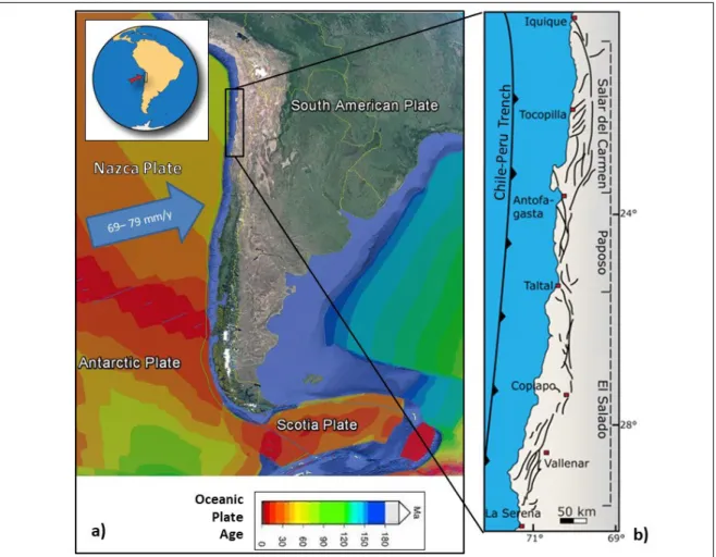
(34) Figure 2-1: Morphotectonic context and segmentation of the Chilean Andes. (a) The main physiographic units of the Chilean Andes: Coastal Cordillera, Central Depression, Precordillera, Main Cordillera, and Patagonian Cordillera (compiled and modified from Mpodozis and Ramos, 1989; Cembrano et al., 2007; Riquelme et al., 2007; Mpodozis and Cornejo, 2012; Armijo et al., 2015). Red triangles symbolize the present-day volcanic arc. Gray lines show the depth in km of the SLAB-1 model (Hayes et al., 2012), which represents the interface of the converging plates relative to the trench (bold black line). The graphs show: (b) Convergence vector obliquity. 21.
(35) and convergence rate (Angermann et al., 1999); (c) the age of the subducting plate from north to south (Müller et al., 1997) and heat flow from Stein (2003); (d) maximum trench depth (shown in orange; Lindquist et al., 2004), which diminishes from N to S, and sediment filling depth (yellow; Bangs and Cande, 1997; Hampel et al., 2004), which increases from 33°S to the south; (e) average annual precipitation along the Chilean forearc (New et al., 2002) and topographic elevations of the Andes (Lindquist et al., 2004); and (f) variation of the crustal elastic thickness (Tassara and Yáñez, 2003).. Additionally, the Chilean continental lithosphere is also longitudinally segmented into three main tectonic domains aligned parallel to the Chilean coastal margin: namely, the Outer Forearc (OF), Inner Forearc (IF), and Volcanic Arc (VA). These domains are associated with the main physiographic units of the Chilean Andes: the Coastal Cordillera, the Central Depression, and the Main and Patagonian Cordilleras, respectively (Pankhurst and Hervé, 2007). These units broadly correspond to the seismic regionalization proposed along Chile by Barrientos (1980), which is used by the Chilean Seismic Design of Buildings Code (Chilean Standard NCh 433), which only accounts for the subduction earthquake hazard. The aforementioned tectonic segmentation results in diverse deformation styles and subduction convergence rates along the length of Chile, as exemplified by the different fault systems (compressional, transpressional, normal, and strike-slip) and the strain partitioning across the Chilean Andes, which have been active within the same converging regime since the Late Cretaceous and none of which have covered the entire 3500 km length of the mountain range (Hoffmann-Rothe et al., 2006). Inherited structural anisotropy and current geodynamical conditions further complicate the understanding of the seismogenic potential of crustal faults in Chile. The complicated interaction between the Nazca and South American plates has also complicated the understanding of plate interaction in other Andean countries, such as Peru and Ecuador, where the relationship between subduction and crustal seismicity is only just beginning to be understood (e.g., Machare and Ortlieb, 1992; Paris et al., 2000; Machare et al., 2003; Allmendinger and González, 2010; Costa et al., 2010; Alvarado et al., 2014; Yepes et al., 2016; Alvarado et al., 2016). 22.
(36) Table 2-1: Latitudinal tectonic segmentation of the Chilean Andes.. Segment. Arica– Copiapó Copiapó– Santiago Santiago– Arauco. Continental. Subduction. Crustal. Elastic. Coupling. Volcanic. margin trend. Angle (º). Thickness. Thickness. level. arc (actual). N-S. N-S. NNE. Arauco– Chile Triple Junction. N-S. Normal. Up to. ~25–30°E. 70 km. Flat ~5°E Normal ~25–30°E Normal ~25–30°E. Trench. Cenozoic. Trench. Andean. depth. shortening. (km). 200–300 km. >7.0. 0. 6.0–6.5. <0.5. sediment fill (km). Low (<10 km) in. High. Active. arc Very low. Up to 60 km (0–5 km) in. -. Non-active 100–200 km. arc <60 km. <10 km. (high-to-. (medium to. normal). high). <40 km (normal to low). Medium. >35 km. Medium to. (high). low. Active. 50–100 km. 5.0–6.0. 0.5–1.0. Active. <50 km. <5.0. >1.0. Data compiled from: Jordan et al. (1983a, 1983b), Tassara and Yáñez (2003), Yáñez and Cembrano (2004), Asch et al. (2006), Tassara et al. (2007), Ramos (2009b), Gerbault et al. (2009).. 23.
(37) 2.3. Use of Geological and Paleoseismological Data in the Analysis of Seismic Hazard: Issues and Challenges. The amount, repeatability, and age of last movement on a fault are often included under the concept of fault “activity” and its related hazard. However, despite being widely used, the concept of fault activity has proved to be highly controversial and misleading, since it has no agreed definition (Costa et al., 2006a). For example, an “active fault” can refer to one which has undergone slip in either historic, Holocene, or Quaternary times, depending on the author (e.g., Wallace, 1986; Yeats et al., 1997; Aki and Lee, 2003; McCalpin, 2009; USGS, 2018b). Still other authors define active faults as ones “that may have movement within a future period of concern to humans” (Wallace, 1981), or else fail to define the term at all. In order to assess the seismic hazard posed by a given fault, it is first necessary to identify whether that fault is capable of generating an earthquake. The seismogenic potential of a fault—that is, the size and recurrence rate of the earthquakes it produces— may be clearer and more tectonically significant when that fault is viewed in the geodynamic context of the subduction earthquake cycle. For example, inactive crustal faults which are optimally oriented with respect to inter- or co-seismic stress fields may be reactivated and produce shallow earthquakes with magnitudes of up to Mw 7 (e.g., Farías et al., 2011; Aron et al., 2013; González et al., 2015). This scenario is particularly relevant for optimally oriented basement (inherited) crustal faults undergoing sudden high strain rates, a condition which can potentially be achieved co-seismically with large megathrust subduction earthquakes (Mw >8; King et al., 1994; Stein et al., 1994; Stein, 1999; Kilb et al., 2000; Lin and Stein, 2004; Loveless et al., 2010; Seeber and Armbruster, 2000). In contrast, during the inter-seismic period, when the crustal deformation rate is relatively low, the reactivation of optimally oriented faults may be less likely (e.g., Aron et al., 2014). The estimation of earthquake magnitudes from geological data is typically performed using empirical relationships and assumed earthquake parameters based on the 24.
(38) premise that the rupture parameters of an earthquake are proportional to its magnitude (Slemmons, 1977; Hanks and Kanamori, 1979; Bonilla et al., 1984; Slemmons and de Polo, 1986; Wells and Coppersmith, 1994; Hanks and Bakun, 2008; Wesnousky, 2008; and many others summarized in Stirling et al., 2013). Accordingly, the rupture length and surface displacement, which are preserved in the paleoseismological record, can be used in empirical regression relationships to estimate earthquake magnitude. The uncertainties of these parameters must be considered, and the assumption that a fault will always rupture with a constant displacement and slip rate, thus creating a “characteristic earthquake”, must be used with caution (Kagan, 1993; Burbank and Anderson, 2001; McCalpin, 2009). Accordingly, the assessment of the key parameters in the field, and the subsequent estimation of other parameters using empirical relationships, are subject to significant uncertainties (see McCalpin (2009) for a review). Models of fault behavior acknowledge that faults may be segmented into discrete sections that act distinctly over their seismic cycle (e.g., Schwartz and Coppersmith, 1986; Slemmons, 1995). Such segmentation can control the onset and termination of fault rupture, and accordingly can also control the size of the rupture area and earthquake magnitude (Grant, 2002). Commonly, the length of a single fault segment (which may be identified through field observations and/or satellite imagery) indicates the maximum possible surface rupture length during an earthquake, since field features are formed by several ruptures over time. Furthermore, if an inappropriate work scale is chosen, several consecutive segments could be mistaken for a single one. Additionally, fault segments which have generated earthquakes independently of each other may be capable of combining to generate a single segment rupture and thereby generate an earthquake of higher magnitude (e.g., Estay et al., 2016). The co-seismic displacement of faults is another difficult parameter to assess. The reason for this is that slip is often measured from a colluvial wedge, which forms coseismically in dip-slip faults (Nelson, 1992; McCalpin, 2009); this estimation requires the assumption that the colluvial wedge has not experienced erosion, represents a single event, and is representative of the entire rupture zone slip. If all of these assumptions are met, the height of the colluvial wedge is considered to be half of the total slip displacement 25.
(39) (McCalpin, 2009). Accordingly, paleoseismological studies should be conducted along the entire length of a fault in order to better represent its behavior. Even when all of this is taken into account, the estimation of earthquake size via paleoseismological or terrain analysis techniques introduces uncertainties which may be difficult to constrain.. 2.4. Historical and Instrumentally Recorded Crustal Earthquakes. Seismic data is an essential tool to constrain and characterize plate tectonics. Major seismic catalogs, such as those maintained by the International Seismological Centre (ISC), the National Earthquake Information Centre (NEIC), the ANSS Comprehensive Earthquake Catalog from the USGS (2018a), the Integrated Plate Boundary Observatory Chile (IPOC), and Harvard Centroid Moment Tensor (CMT), include data from crustal earthquakes all over the Chilean Andes. Nevertheless, in several cases, the hypocentral locations of these events are not sufficiently well constrained to distinguish shallow intracrustal earthquakes from subduction earthquakes. This is particularly important for events recorded in the forearc, where seismicity in the overriding plate detected from teleseismic observations is often masked by the stronger interplate seismicity. Nevertheless, catalog data show a clear concentration of seismicity in the Chilean forearc region, in contrast with scarce intraplate crustal seismicity in the Main Cordillera of the Andes (e.g., Pardo et al., 2002; Asch et al., 2006). Along the length of the Central and Southern Andes, intraplate seismicity tends to be localized within the weak lithosphere, where the brittle– ductile transition is located at less than 15 km depth (Tassara et al., 2007). There are relatively few published studies which document crustal earthquakes in Chile (e.g., Pardo et al., 2002; Barrientos et al., 2004). In recent years, the Pichilemu Mw 7.0 earthquake (which struck 12 days after the 2010 Maule interplate mega-earthquake) and the Pisagua Mw 6.7 earthquake (16 days before the 2014 Iquique interplate earthquake) have attracted the attention of geologists and seismologists. These events motivated several studies regarding the nature of these events and their tectonic significance in the subduction cycle, due to their spatial proximity to the trench and the 26.
(40) fact that they were temporally associated with Mw 8.8 and Mw 8.1 interplate earthquakes (e.g., Farias et al., 2011; Aron et al., 2014; González et al., 2015). In order to assess the modern crustal seismicity in the Chilean Andes, we used the Harvard CMT catalog (http://www.globalcmt.org/), which is one of the most accurate global seismic event catalogs (Kagan, 2002). When hypocentral depth is undetermined (which is the case for more than 30% of historical earthquakes in the different earthquake catalogs), a hypocentral depth is assigned based on tectonic setting or nearby seismicity (Bondar et al., 2015). The CMT catalog assigns events a “fixed-depth solution” with an assumed hypocenter located at a depth of 10, 15, or 33 km. The CMT catalog was searched for earthquakes located in the Chilean Andes having hypocentral depths shallower than 50 km and magnitudes above Mw 4.9 and occurring in a 39 year period between January 1976 and April 2015. This search yielded 6601 events. The information for each event included the date, latitude, longitude, depth, half-duration, moment tensor, magnitude metrics (Mw, Ms, mb, etc.), and fault-plane solution. From this population we selected 372 earthquakes that were considered to be of crustal origin by eliminating events that were determined to be subduction-related via analysis of their focal mechanisms while also eliminating events with poorly determined hypocentral locations (Figure 2-2). These 372 events are spatially distributed in two bands, one in the coastal outer forearc and one located inland in the volcanic arc. Several earthquakes from this population of 372 events have been of scientific and/or public interest due to their large magnitude (Mw >6.0) and shallow hypocentral depth (<16 km). The epicentral locations of these events are distributed across several different latitudinal and longitudinal domains and are good models of crustal earthquake types, as explained later in this section (see Table 2-2). Moreover, the hypocenters and focal mechanisms of some of these earthquakes correspond strongly with the identified traces and slip characteristics of crustal faults in the region. In this section, we detail some prominent crustal earthquakes (Mw >6.0) among the 372 crustal earthquakes that were selected from the CMT catalog (see Figure 2-2).. 27.
(41) Figure 2-2: Map showing the locations of 372 crustal earthquakes recorded along the Chilean Andes between January 1976 and April 2015. Data are taken from the Harvard Centroid Moment Tensor (CMT) catalog (http://www.globalcmt.org/). Circle sizes correspond to magnitude. Focal mechanisms of crustal earthquakes with Mw ≥6 are displayed. Larger historical crustal events are highlighted with red focal mechanisms: Aroma 2001, Iquique 2015, Las Melosas 1958, Pichilemu 2010, Teno 2004, Aysén 2007, and Magallanes 1949.. 28.
(42) Table 2-2: Selected instrumentally recorded crustal earthquakes in Chile.. Location. Year. Aroma. 2001. Las Melosas. 1958. Pichilemu. 2010. Teno. 2004. Aysén. Aysén. 2007 (21 Apr) 2007 (02 Apr). Epicentral Location. Magnitude. Longitude. (Mw). Latitude (°S). 6.3. 19.5. 69.2. ~5.0. 33.9. 70.2. 5.0–9.0. 34.5. 72.1. 34.9. 70.6. 6.3 6.9-6.7-6.8 6.9 7.0 6.5. (°W). 6.2. 45.4. 73.0. 6.1. 45.4. 73.1. 29. Depth (km). Reference. Legrand et al. (2007) Alvarado et al. (2009) Sepúlveda et al. (2008). Longitudinal Tectonic Domain Inner forearc Arc. ~12.9. Farías et al. (2011). Outer. 16.3. Aron et al. (2013). forearc. 4.7. González (2008). Arc. <8.0. Mora et al. (2010). 4.0. Legrand et al. (2011). 5.3. Legrand et al. (2011). Arc. Arc.
(43) 2.4.1 2001 Aroma Earthquake, Inner Forearc Domain A Mw 6.3 earthquake occurred on 24 July 2001 in the Aroma region of Northern Chile (Table 2-2, Figure 2-2). This event is one of the few shallow earthquakes to have occurred in Northern Chile in recent years (Comte et al., 2001). Legrand et al. (2007) used seismic data to locate the event and its aftershocks. Additionally, the same authors constrained the focal depth of the event using the SP phase and its focal mechanism. Their analysis returned a fault plane solution of the main event with a strike of 14 ± 10°, a dip of 53 ± 15°, and a rake of 163 ± 15°, indicating dextral movement on an oblique fault. This is consistent with the distribution of aftershocks, which indicated a fault direction of N14°E and a dip of 50°E. Additionally, Legrand et al. (2007) determined the earthquake’s hypocentral depth to be 5 ± 1 km, although neither surface deformation nor related morphotectonic features were reported. 2.4.2 1958 Las Melosas Earthquake, Volcanic Arc Domain On 04 September 1958, a seismic event with a hypocentral depth of 15 km was recorded in the Cordillera Principal region, near the intersection of the Maipo and Volcán rivers (Table 2-2, Figure 2-2). No field evidence of surface rupture associated with this event was observed (Sepúlveda et al., 2008). The earthquake involved a sequence of three separate events with surface wave magnitudes of between Ms 6.7 and 6.9 (Sepúlveda et al., 2008) and moment magnitudes of Mw 6.3 (Alvarado et al., 2009). The focal mechanism of the main event is consistent with either sinistral slip on a NS-oriented fault plane or dextral slip on a nearly EW-striking fault plane (Lomnitz, 1960; Sepúlveda et al., 2008; Alvarado et al., 2009; Alfaro, 2011). Sepúlveda et al. (2008) analyzed the hazard associated with the Las Melosas earthquake, estimating intensities and Peak Ground Acceleration (PGA) values from the reinterpretation of historical documents and the study of landslides caused by similar earthquakes. The maximum felt intensity (MSK scale) was 9 in the epicentral area and 6 at a distance of 40 km from the hypocenter. Furthermore, according to analysis of two landslides, which were triggered by this event using the Newmark method, a PGA of 0.58–1.30 g was estimated for the event. These findings 30.
(44) highlight the large seismic hazard that exists near this blind fault, which occurs close to the El Fierro Fault System (Farías et al., 2010). 2.4.3 2004 Teno Earthquake, Volcanic Arc Domain A magnitude Mw 6.7 earthquake occurred on 28 August 2004 in the Cordillera Principal of the Maule region, near the headwaters of the Teno River, north of Peteroa volcano (Comte et al., 2008; González, 2008; Alfaro, 2011). According to the National Seismological Service of Chile, the hypocenter was located at 35.2°S, 70.5°W, and 5 km depth, with a local magnitude of ML 6.2. The focal mechanism for this event given in the Harvard CMT catalog indicates either dextral movement on a fault plane 21/61 and a rake of –178 or sinistral movement on a fault plane 290/88 and a rake of –29. González (2008) relocated the hypocenter at 34.9°S, 70.5°W, and 4.7 km depth. By analyzing aftershocks which occurred near to this structure, she was able to delimit a structure trending N20E and dipping to the west with a length of 18 km and a depth of 11 km. The same author also suggests a northward spreading of the rupture, from the area of Termas del Flaco to the Maipo River valley, where a Mw 5.6 magnitude earthquake with a reverse focal mechanism occurred on 12 September 2004. If we consider the focal mechanism reflecting a NNE-oriented structure and associated dextral fault movement, this earthquake would relate coherently with east-vergent fault systems that reflect the tectonic control proposed by various authors in the south-central Principal Cordillera area (e.g., the El Diablo Fault in Fock, 2005 and the El Fierro fault in Farías, 2007). The intensities recorded by the Chilean National Seismological Service for the Teno earthquake reveal that only moderate-to-weak damage was caused in the Teno area, with a maximum intensity of VI on the Modified Mercalli Intensity Scale, while in the Talca and Curicó areas, intensities of V to VI were recorded. 2.4.4 2007 Aysén Earthquakes, Volcanic Arc Domain In 2007, a swarm of 7200 events occurred within a small area in the Aysén Fjord region of Southern Chile. The largest two earthquakes in this swarm were the Mw 6.1 and 31.
Figure


+7


Documento similar
1. S., III, 52, 1-3: Examinadas estas cosas por nosotros, sería apropiado a los lugares antes citados tratar lo contado en la historia sobre las Amazonas que había antiguamente
In the previous sections we have shown how astronomical alignments and solar hierophanies – with a common interest in the solstices − were substantiated in the
Even though the 1920s offered new employment opportunities in industries previously closed to women, often the women who took these jobs found themselves exploited.. No matter
MD simulations in this and previous work has allowed us to propose a relation between the nature of the interactions at the interface and the observed properties of nanofluids:
The expansionary monetary policy measures have had a negative impact on net interest margins both via the reduction in interest rates and –less powerfully- the flattening of the
Jointly estimate this entry game with several outcome equations (fees/rates, credit limits) for bank accounts, credit cards and lines of credit. Use simulation methods to
In our sample, 2890 deals were issued by less reputable underwriters (i.e. a weighted syndication underwriting reputation share below the share of the 7 th largest underwriter
Hydrogeological characterization ... Thermal anomaly origin ... Permeability from fractures ... The main aquifers ... The hydrogeological functioning ... Thermal conductivity
