--- -
.
.
~--- - - - Car/Griesebner /Strobl (Eds.)
G
s
tial
Cross...
a
s
@
...,. '08
-Proceedings of the
Geoinformatics Forum Salzburg
AII explanations, data, results etc. contained in this book have been made by the authors to the best of their knowledge and have been approved with careo However, some errors could not be excluded. For this reason the explanations etc. are given without any obligations or guarantee by the authors, editors and publisher. They cannot take over any responsibility for eventual erroneous contents.
Bibliographic information published by the Deutsche Nationalbibliothek
The Deutsche Nationalbibliothek lists this publication in the Deutsche Nationalbibliografie. Detailed bibliographic data are available in the Internet at http://dnb.d-nb.de.
ISBN 978-3-87907-465-5
© 2008 Herbert Wichmann Verlag, Verlagsgruppe Hüthig Jehle Rehm GmbH, Heidelberg, München, Landsberg, Berlin
AII rights reserved. No part of this book may be reproduced in any form, or any means, electronic or mechanicaf, including photocopying, recording, or by any information storage and retrieval system, without permission in writing from the publisher.
Printing: Media-Print, Paderborn
1
2
Spatial Analysis for Conservation Status Assessment
Within Natura 2000 Network in tbe Forest Area
"Prado de Robledela" (Ávila, Spain)
The GI_Forum Program Committee accepted this contribution for participation in
a Discussion Session.
Rosario TEJERA, Javier VELÁZQUEZ, Ana HERNANDO, Maria Victoria NÚI\IEZ. Francisco MAURO and Antonio GARCÍA
Introduction
The aim of the Directive 92/43/EEC (EEC, 1992), commonly known as Habitats DireCli\c. "sha11 be to contribute towards ensuring bio-diversity through the cOl1selvation 01' natural habitats and of wild fauna and flora in the European teITitory of lhe Member Stales lo which the Treaty applies" (Article 2). Because of it, it is necessary to ensure the pertinent measures which may help to evaluate the status conservation (Article La) 01' the natural habitats included in Natura 2000 Network. To facilitate this work il is necessary to compil~
and process this information with GIS tools.
Objective of the study
• To establish a methodology of spatial analysis to evaluate the conservation status assessment of habitats included in Annex 1 of Habitats Directive.
• To provide an environmental evaluation of the study area.
Description of the study area
-'="
.
~,:~. ~ ~"Prado de Robledela"
- -
ti ~)~ 11»] "Z~<::
Spatial Analysis for Conservation Status Assessment Within Natura 2000 Network 253
IS
Assessment
i'orest Area
Fig.l: Location of"Prado de Robledela" and topography ofthe space
3
Methodology
The first step of the methodology was the elaboration of habitats cartography by means of inventory fieId work, aerial photos interpretation and terrestrial mapping, using GIS (TEJERA GIMENO et al., 2007).
The following figure presents the general scheme for the methodology:
I
cQnsm,atmnj
statu;
Conservation status
The evaJuation of "conservation status" of natural habitats is based on the "Natura 2000 Standard Data Form" for sites monitoring (EUROPEAN COMiVIISSION, 1995, 1996; ELLMAUER, 2005; SHAW & WIND, 1997). The conservation status is c1assified into three classes from "A" to
"c"
where "A" is an excellent status or most favourable, "B" is a good status and"c"
is the least favourable. For this purpose these five factors are considered: vital functions, richness of flora, habitat coverage, forest structure and capacity of restoration.Fig.2: Methodological scheme of conservation status assessment
paio)
for participa/ion in
1aria Victoria NÚÑEZ,
A
wn as Habitats Directive, e conservation of natural )f the Member States to
y
to ensure the pertinent .rtic1e I.a) of the natural it is necessary to compilethe conservation status
'e.
ra 2000 Network, callcd Spain (Figure J). This ; a part of the Space of
PA) called "Pinares del Habitats Directive, four 0*). A huge number of
.
_ n
A
254 R. Tejera, 1. Velázquez, A. Hernando, M. V. Núñez, F. Mauro and A. García
The geomatics applications in ArcG[S 9.1, PCI, eCognition, and ENVI are used to analy>e the local and regional coverage, to calculate areas and structure from vector and raster files (Instituto Nacional de Ecología).
The factors used to define the conservation status have been integrated into a doting-cross matrix (Table 1) using the following criteria.
Table 1: Criteria used for the integration of factors in the conservation status assessment
Factor 1
A B
e
N
...
o...
...
'"
lJ;, A Be
A A B A B B B Be
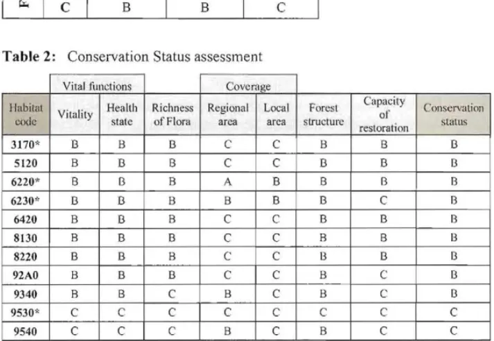
Table 2: Conservation Status assessment
Vital fllnctions Covcrage ¡Iabitat
codc Vitality Health state Richness ofFlora Regional area Local area Foresl strllcrllrc Capacity 01' restorarion COJlservation status
3170* B B B C C B B B
5120 B B B C C B B B
6220* B B B A B B B B
6230" B B B B B B
e
B6420 B B B
e
e
B B B8130 B B B
e
e
B B B8220 B B B
e
e
B B B92AO B B B
e
e
Be
B9340 B B
e
Be
Be
B9530*
e
e
e
e
e
e
e
e
9540
e
Ce
Be
Be
e
With these result it is possible to obtain a useful digital cartography that will provide the managers with an environmental diagnosis of the area.
Discussion and Outlook
The result of conservation status assessment is a good reflection of the situation observecl in the study area "Prado de Robledela" during the inventory phases and the different tasks calTied out under the management plan of this area. [n fact, the unfavourable conservation status observed in previous field work in habitats 9530* and 9540 fits correctly with the value C obtained within the assessment (TEJERA GIMENO, 2007).
lauro and A. García Spatial Analysis for Conservation Status Assessment Within Natura 2000 Network 255
ld ENVI are used to analyse
~from vector and raster tiles
ltegrated into a doting-cross
ervation status assessment
:y
)11
COl1servmiol1
~
status
B
B
B
B
B
B
B
B
B
C C
tphy that wiU provide the
'the situation observed in s and the different tnsks nfavourable conservation 10 fits correctJy with the
The methodology for the conservation status assessment is a very useful tool for Natura 2000 managers. It considers quaIitative aspects of the territory that can be integrated in GIS. On the other hand, there are other methods focused on more quantitative indicators based on field work (BALTIC ENVIRONMENTAL FORUM, 2005; MÜLLER-KROEHLING, et al., 2004).
References
BALTlC ENVIROMENTAL FORUM (2005), Implementation of biodiversity monitoring require ments according requirements to the Habitats Directive in the EU Member States, Sigulda, Latvia.
EEC (1 992):,Directive 92/43/EEC on the Conservation of Natural Habitats and Wild Fauna and Flora.
ELLMAUER, T. (2005), Entwicklung von Kriterien, Indikatoren und Schwellenwerten zur Beurteilung des Erhaltungszustandes der Natura 2000-Schutzgüter.
EUROPEAN COMMIsrON (1995), Natura 2000 standard data form for Speciai Protection Areas (spa) for sites eligible for identification as Sites of Community Importance' (SC!) and for Special Areas ofConservation (SAC).
EUROPEAN COMMISSION (2006), Assessment, monitoring and reporting under Article 17 of the Habitats Directive: Explanatory Notes & Guidelines.
INSTITUTO NACIONAL DE ECOLOGÍA, "Elementos para diferencia unidades de vegetación a diversas escalas, su representación espacial z su caracterización en sistemas de información geográfica o con imágenes de satélite";
http://www.ine.gob.mx/ueajei/publicaciones/libros/443/cap3.html
MÜLLER-KROEHLING, S., FrscHER, M., GULDER, H.-J., WALENTOWSKI, H. Y. & K6LLING,
C. (2004), Arbeitsanweisung zur Fertigung von Managementplanen fur Waldtlachen in Natura 2000-Gebieten.
SHAW, P. & WIND, P. (1997), Monitoring the condition and biodiversity status ofEuropean Conservation Sites.
1
GIS and Remote Sensing for Natura 2000 Monitoring
Ta"1
in Mediterranean Biogeographic Region
siIl
Javier VELÁZQUEZ, Michael FÓRSTER and Birgit KLEINSCHMIT
t(1
s~
The GI_Forum Program Committee accepted this paper as reviewed full papero
:N
tI
Surnmary
NATURA 2000 areas monitoring is a key research topic on European countries since
Habitat Directive specifies the obligatjon to implement monitoring systems for í]
J
conservation status in Natura 2000 spaces. This can be achieved by combining GIS-based t·
I'J
models of the Potential Natural Vegetation (PNV) with remote sensing classificatioll ol' t
.
interpretation results. The presented study focuses on the implementation of a methodology (
to locate and detect changes in forest spaces ofNatura 2000 Network. Location of different habitats types were carried out based on geo-factors and remote sensing interpretation, terrestrial mapping and analysis of natural habitat distribution 1'01' a test site.
In order to derive the actual forest habitats, potential natural vegetation was derived from a defined rule-set, in which the habitat types with the highest possibility 01' occurrence could be ranked accordingly. The result of the modelling for potential natural vegetation was verified using available satellite data (LANDSAT TM). This task was carried with a maximum likelihood classification using the software PCI Geomatica. The results of tbe c1assification and the GIS analysis are combined to obtain preliminary habitat types. These types were verified with existing Forest Management Plans, and compared with results of local terrestrial mapping and natural distribution of habitat types.
Keywords: Potential Natural Vegetatíon, geo-factor, object-based c1assification, natural distribution.
Introduction
The monitoring ofNATURA 2000 areas within the EU is still a challenging task. Recently, there are more precisely defined 1110nitoring guidelines available on European level (European Commission, 2006). Therefore, it is not sufficient to assess and evaluate the conservation status of habitats and species only within the Special Areas of Conservation (SAC) of the NATURA 2000 network, but additionally on the biogeographical leve!. The EU defines biogeographic regions as a geographical framework for the establishment of a draft list of sites of Community importan ce from the membership states. This area-wide assessment is necessary because of possible smal! scale changes of the biodiversity network.