Analysis of the environmental licensing procedure for coastal environments in Colombia: A
Geomorphological perspective from the concept of susceptibility to the effect of human
interventions
Análisis del procedimiento de licenciamiento ambiental para entornos costeros en
Colombia: una perspectiva geomorfológica desde el concepto de susceptibilidad al efecto
de intervenciones humanas
CRISTINA I. PEREIRA P.
Ph. D. Thesis
Advisors
Ph. D. Ivan Correa (Universidad Eafit)
Dr. Enzo Pranzini (Università degli Studi di Firenze)
UNIVERSIDAD EAFIT
MEDELLÍN
ESCUELA DE CIENCIAS
3
TABLE OF CONTENT
ACKNOWLEDGEMENT ... 13
ABSTRACT ... 15
RESUMEN ... 19
GENERAL INTRODUCTION ... 24
i. Prologue ... 24
ii. Background and justification ... 25
Geomorphology discipline or disciplines? ... 25
Environmental impact ... 27
Coastal environmental zoning ... 28
Justification ... 31
iii. Study area, hypothesis and objectives ... 32
iv. Critical analysis of the background... 34
Geomorphology and environmental management ... 34
Coastal Geomorphology and the natural processes ... 35
Environmental licensing procedure (ELP) ... 36
Environmental information status of the Colombian coastal zones ... 38
v. Thesis structure ... 39
vi. Research contributions ... 42
CHAPTER I ... 43
The historical, geomorphological evolution of the Colombian littoral zones (XVIII century to present) ... 43
1.1. Abstract ... 44
1.2. Introduction ... 44
1.3. Main historical morphological changes along the central Caribbean coast of Colombia ... 46
1.3.1. General context ... 46
1.3.2. Historical morphological changes along the Magdalena river delta shores and prodelta48 1.3.3. Historical morphological changes between Galerazamba (La Garita point) and the Sinú-Tinajones delta. ... 53
1.3.4. Infrastructure for Coastal protection ... 56
1.4. Main historical geomorphological changes along the Pacific Littoral of Colombia ... 58
1.4.1. General context ... 58
1.4.2. Historical coastline changes along the Barrier islands of the Pacific Coast ... 61
1.5. Final remarks ... 62
CHAPTER II ... 66
4
2.1. Abstract ... 67
2.2. Introduction ... 67
2.3. Methods ... 70
2.4. Results and analysis ... 71
2.4.1. Environmental licensing procedures ... 71
2.4.2. Types of interventions subjected to environmental licensing ... 73
2.4.3. Criteria for characterization of the coastal environment ... 76
2.5. Good practices for environmental licensing of coastal interventions ... 78
2.5.1. The integration of screening and scoping stages within the ELP ... 78
2.5.2. Evaluation focused on the environment rather than the intervention ... 80
2.5.3. The inclusion of the coastal zone delimitation in the environmental licensing ... 80
2.5.4. The institutional articulation in the ELP ... 81
2.5.5. Accreditation of environmental consultancies for conducting EIS ... 83
2.5.6. Pertinent official guidelines for sensitive EIA stages according to types of environments 83 2.5.7. The integration of environmental geographic information ... 85
2.6. Conclusions ... 86
CHAPTER III ... 88
Anthropogenically impacted coast: An evaluation of human interventions in the Caribbean Coast of Colombia... 88
3.1. Abstract ... 89
3.2. Introduction ... 89
3.2.1. Study area: The CCC ... 90
3.3. Methods ... 93
3.3.1. Inventory ... 93
3.3.2. Environmental Impact Estimation ... 94
3.4. Results and discussion ... 95
3.4.1. Coastal interventions in the CCCC ... 95
3.4.2. Environmental impact of interventions with effect in the coastal zone ... 100
3.5. Conclusions ... 104
CHAPTER IV ... 106
Regulating human interventions in coastal areas: policy implications of the environmental licensing procedure... 106
4.1. Abstract ... 107
4.2. Introduction ... 107
4.2.1. ELP context in Colombia ... 109
4.2.2. Study area: The CCC ... 110
4.3. Methods ... 111
4.4. Results and Discussion ... 112
4.4.1. Regulation of human intervention in the CCC ... 112
4.4.2. Policy implications of coastal interventions ... 117
5
CHAPTER V ... 121
Susceptibility to the effect of human interventions: Design and demonstration of a conceptual and methodological model to improve the environmental licensing of coastal interventions ... 121
5.1. Introduction ... 122
5.1.1. Conceptual scheme of susceptibility to the effect of human interventions ... 123
5.1.2. The SHIELP application for coastal environments ... 125
5.2. Methods ... 125
5.2.1. Parameter definition of the SHIELP model for coastal environments (see Figure 5.2.) 127 5.2.2. Architecture of the SHIELP expert –diffuse system: inputs generation ... 128
5.2.3. SHIELP model computations ... 133
5.2.4. Study case ... 134
5.3. Results and analysis... 138
5.3.1. Methodological approach of SHIELP ... 138
5.3.2. Parameters of the SHIELP model for coastal environments ... 140
5.3.3. Matrix of processes’ Importance of littoral configurations (see Appendix V-B) ... 144
5.3.4. Matrix of processes’ Affectation due to human interventions (see Appendix V-C) ... 146
5.3.5. Susceptibility matrix ... 148
5.3.6. Littoral configurations in the ECU Mag-Dique ... 152
5.3.7. SHIELP results for the ECU Mag-Dique ... 157
5.3.8. Application of the SHIELP model in environmental management ... 159
5.4. Discussion ... 164
5.4.1. Natural processes influencing the coastal morphology... 164
5.4.2. Morphological configurations of the SHIELP model for coastal environments ... 165
5.4.3. Littoral configurations of the SHIELP model in the ECU Mag-Dique ... 167
5.4.4. Combined system to estimate the geomorphological susceptibility to human perturbations 171 5.4.5. The applicability of the SHIELP model ... 172
5.4.6. Changing approaches of EIA from the susceptibility concept ... 179
5.5. Conclusions ... 180
OVERALL CONCLUSIONS ... 182
6
List of Figures
Figure i. Aerial view of coastal limits used for land-sea planning and integrated coastal zone
management. Modified from Milanes (2018) ... 29
Figure ii. Environmental units of the Colombian Caribbean regions. Taken from MMA (2000) ... 30
Figure iii. Environmental units of the Colombian Pacific region. Taken from MMA (2000) ... 31
Figure iv. Holistic cycle of the scientific research. Adapted from Hurtado (2010) ... 33
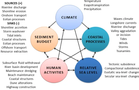
Figure 1.1. Factors affecting coastal environments. After Morton and Pieper (1977) and Williams et al. (1995). ... 45
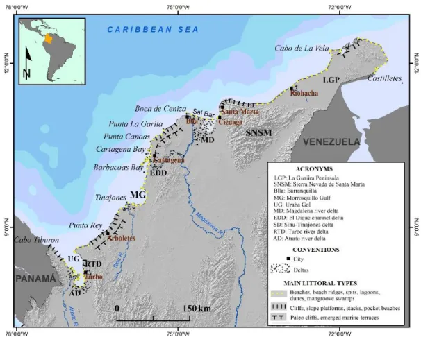
Figure 1.2. Location map and main morphological types of the Colombia Caribbean littoral. ... 47
Figure 1.3. Magdalena river delta shores, 1852 and 1934. Upper: Magdalena river delta coastline and offshore bars to Puerto Colombia, including Isla Verde; chart published in 1852, taken from Comisión Corográfica y de orden del Gobierno General, por Manuel Ponce de León y Manuel María Carta corográfica del Estado de Bolívar, la Paz, Bogotá, 1864. Down: USS Nokomis Chart 5688, after hydrographical surveys data obtained during 1935-1936. ... 50
Figure 1.4. Comparison of shoreline configuration west of the Magdalena river mouth between 1928 and present, indicating the swamp surface lost since the construction of the channelling works of Bocas de Ceniza in red and the remnant of the lagoon system of the current delta in green. The historical map represents the progress of the channelling works at Bocas de Ceniza by 1928. Sources: Rico (1967). ... 51
Figure 1.5. Submarine slides at the Magdalena delta front. Upper: paths of submarine slides and location of cable´s breaks. After Heezen (1956). Down: submarine profiles changes along the Magdalena delta front after the 1935, 1953, 1957 and 1963 submarine slides; after Rico in Koopmans (1971). ... 52
Figure 1.6. Historical coastline changes at Galerazamba (La Garita Point) and Isla Cascajo area, Barranquilla-Cartagena littoral from Brigadier Fidalgo chart made with field data from the end of the XVIII century. Current configuration of shoreline is depicted in yellow along with the conventions G: la Garita Point, IC: Cascajo Island, MV: Morro de La Venta Point, north-eastern extreme of Isla Cascajo tombolo, PP: Punta de Piedra point, southwestern extreme of Isla Cascajo tombolo.... 53
Figure 1.7. Galerazamba (Punta Garita) area coastline changes and geomorphological features. A) net coastline changes between 1794 y 1996, including the erosion of the Galerazamba spit and the noticeable cliff retreat to the south, in absence of the previous wave protection offered by the spit (from Correa, 1990); B) El Totumo mud volcano, view to the east (Photo by Ivan Correa; C) El Totumo mud volcano – 15 m-height, located on the northern flank of a 70 m-height diapiric dome (Photo by Ivan Correa); D) touristic use of the originally 1 m-wide el Totumo volcano crater (Photo by Ivan Correa); E) High energy dissipative beaches to the east of La Garita Point; F) Active, 7 m-height retreating cliffs south of Galerazamba (photographs by Ivan Correa). The Galerazamba area is famous for several violent explosive events of offshore and onshore volcanoes (at least three in the past century), the last being the explosion (2008) of the Pueblo Nuevo mud volcano that represented a serious risk for the inhabitants of Pueblo Nuevo village. ... 54 Figure 1.8. Isla Cascajo area coastline changes. Historical coastline changes between 1793 and 1990
7
1990). Tombolo formation initiated at some time between 1793 (Fidalgo’s cliffed coastline) and 1937 (coastline depicted in the U.S. Nokomis navigation charts). ... 55 Figure 1.9. Tinajones delta and Cispatá bay. 1938 coastline shown on a nautical chart by the USSNokomis based on surveys made in 1934 ... 55 Figure 1.10. Proportion of shoreline in erosion and with protection by department of the Caribbean
coast. Data from Posada and Henao (2008). ... 56 Figure 1.11. Shore protection structures in the Caribbean littoral. Upper Sector of Marbella in
Cartagena city (Bolivar), where a battery of groins is trapping sediments from the longshore drift towards the southwest (source: Esri Imagery); Down: Southern part of the Gulf of Morrosquillo (Sucre), where a sequence of breakwaters and T-shape groins that do not succeed in stabilizing the highly intervened sandy barrier in front of extensive mangrove swamps. Courtesy of Eafit University. ... 57 Figure 1.12. Location map and main morphological littoral types along the Pacific Coast of Colombia. ... 59 Figure 1.13. El Choncho barrier island. Left: geomorphological units of the southern lobule of the San
Juan river delta; radiometric data taken from beach ridges besides Boca Chavica mouth and comparisons with ancient charts suggest that El Choncho barrier island initiated its formation by the end of the XVII century (From Morton and Correa, 2003). Upper right: El Choncho barrier island central part, photo by Ahmed Restrepo, 1996. Center right: aerial photograph illustrating the initial breaching at the central part of the barrier island, the same area illustrated above (photo by Iván Correa, 1997). Down right: The new Choncho after relocation to the ancient beach ridges - Santa Bárbara beaches - Photo by Iván Correa, November 1998). ... 60 Figure 1.14. San Juan de La Costa. Left: aerial photograph showing the beginning of the
segmentation of the barrier island (taken from IGAC 1979). Right: the two concrete structures (small church) and school were the unique remnants of the two 2.5 m-high tsunami waves that hit the island in December 12, 1979. 250 inhabitants were drowned by this event (photo by Iván Correa, 1989). ... 62
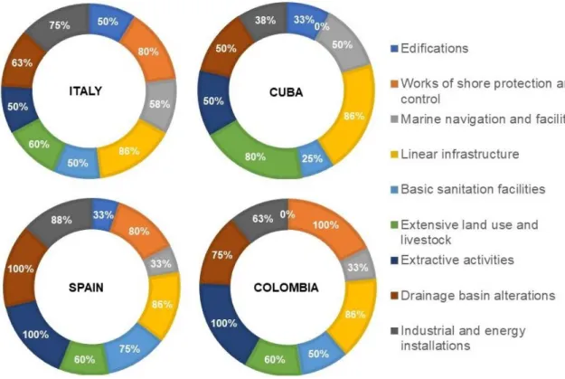
Figure 2.1. Licensing procedure in Italy, Cuba, Spain and Colombia within the IAIA framework. (*Stages that take place only if the environmental authority requires it) ... 72 Figure 2.2. Proportion of interventions with an effect on the coastal zone by country and category. 76 Figure 2.3. Frequency of technical requirements for the EIS preparation of coastal protection works
by territory according to a scheme of natural processes influencing coastal morphology ... 77
Figure 3.1. Study Area: CCCC. Adapted from Correa and Pereira (2019), Carvajal et al., (2010), and Vernette (1989).The acronym MAGDIQUE refers to the unit Magdalena-Canal del Dique and VSNSM to the unit of the northern slope of Sierra Nevada de Santa Marta ... 92 Figure 3.3. Intervention’s distribution according to Environmental Coastal Units in the Colombian
continental Caribbean. ... 96 Figure 3.4. Box plots for the overall TEI values, representing the asymmetric distribution of data (A),
the distribution without extreme outliers (A’), and the distribution without extreme and mild outliers (B). ... 101 Figure 3.5. Values of the unitary (UEI) and total (TEI) environmental impacts estimated for the CCCC.
8
Figure 4.1. Study Area: The CCC. Adapted from the study by Correa and Pereira (2019). Magdique refers to the unit Magdalena-Canal del Dique, and VSNSM refers to the unit of the northern slopeof the SNSM massif. ... 111
Figure 5.1. Conceptual diagram of susceptibility to the effect of human intervention for environmental licensing purposes (SHIELP) ... 124
Figure 5.2. Steps of the research’s methodology ... 126
Figure 5.3. Fuzzy System Architecture to evaluate process perturbation in a given interaction (human intervention vs morphological configuration) ... 132
Figure 5.4. Fuzzy incoming parameters (Importance and Affectation) and resulting output (Perturbation) ... 132
Figure 5.5. Study area: Environmental Coastal Unit “Magdalena River - Canal del Dique complex - Ciénaga Grande de Santa Marta lagoon system” (ECU Mag-Dique) ... 135
Figure 5.6. Mosaic of the 22 maps of Carvajal et al. (2010). ... 137
Figure 5.7. Generic flowchart of the SHIELP model architecture. ... 139
Figure 5.8. Conceptual diagram of the SHIELP for coastal environments ... 144
Figure 5.9. Boxplot of importance values set by processes in the importance matrix. ... 145
Figure 5.10. Boxplot of affectation values set by processes in the affectation matrix. ... 147
Figure 5.11. Proportion of susceptibility levels by interventions (left) and littoral configurations (right). The numbered segments on the left panel correspond to the nine categories of human interventions. ... 150
Figure 5.12.. Generic flowchart of the SHIELP model architecture ... 152
Figure 5.13. Proportion of susceptibility levels by interventions (left) and littoral configurations (right) in the ECU Mag-Dique. ... 158
9
List of Tables
Table 2.1. Type of intervention in the coastal zone subject to EIA procedures in Italy, Cuba, Spain and Colombia ... 73
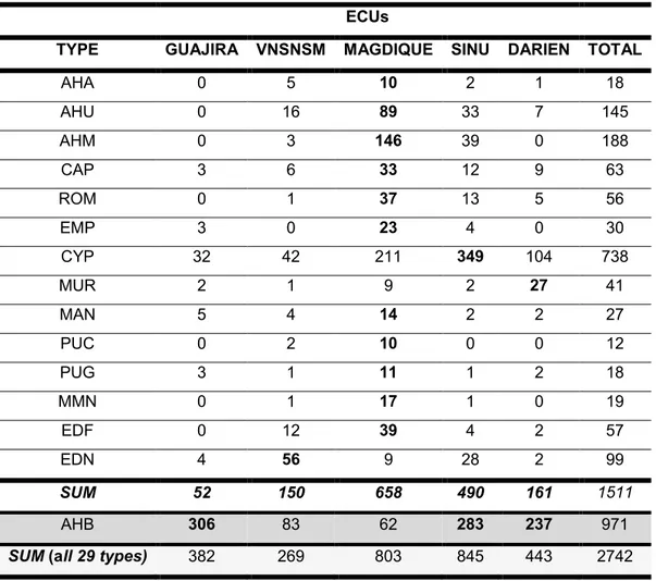
Table 3.1 Number of occurrences of the highly concentrated types of interventions in the study area (the highest value for each category is shown in bold). ... 98
Table 4.1 Top 10 human interventions impacting the CCC. ... 113 Table 4.2. Evolution of the prescriptive character of the environmental licensing of projects, works,
and activities in Colombia, with emphasis on coastal areas. ... 115 Table 4.3. Geographical distribution of human interventions within the five ECUs of the CCC. ... 118
Table 5.1. Elements of the two types questionnaires designed in the online survey service ... 128 Table 5.2. Considerations suggested for the experts during the administration of the questionnaire
type 2 ... 130 Table 5.3. Inference rules of the fuzzy Logic system defined for coastal environments. ... 131 Table 5.4. List of commands used in the MATLAB routine file to run the application of the SHIELP
model of coastal environments in the study case area. ... 133 Table 5.5. Weights of the perturbation levels and the equation to integrate them into a susceptibility
value. ... 134 Table 5.6. List of data used for defining the littoral configurations in the ECU Mag-Dique ... 136 Table 5.7. List of processes defined for the SHIELP model application on coastal environments. . 141 Table 5.8. List of human defined for the SHIELP model application on coastal environments. ... 142 Table 5.9. Emerged and submerged morphological compositions for setting the littoral configurations. ... 143 Table 5.10. Main descriptors of the susceptibility data set and equivalent ranges for susceptibility
levels ... 149 Table 5.11. Occurrences and coverage of the emerged subunits identified in the ECU Mag-Dique. ... 153 Table 5.12. Occurrences and coverage of the submerged subunits identified in the ECU Mag-Dique. ... 154 Table 5. 13. Occurrences and coverage of the 40 littoral configurations identified in the ECU Mag-Dique ... 156 Table 5.14. Parameters for the interpretation of the SHIELP expert-diffuse system in a geographical
region. EIS stands for Environmental Impact Study and NA stands for Not Applicable. ... 160 Table 5.15. Information levels required from each process (Pn) in the environmental impact study
(EIS), according to the type of licensing instrument. Doc. Review stands for documental revision of external data; Model (Doc.) stands for modelling or simulation with documental data; Field Data stands for data collection through field surveys; and Model (Field) stands for modelling or simulation with field data. ... 162 Table 5.16. Comparison between susceptibility and PEI (Potential Environmental Impact) as
10
List of Acronyms and Abbreviations
AHA High-density settlements AHB Low-density settlements AHM Luxury settlement with pier AHP Palatial settlements AHU Luxury settlements
ANLA Autoridad Nacional de Licencias Ambientales (national authority of environmental licensing )
BBD Beach & Bare Dunes BCT Beach & Cliff/Terrace BFP Beach & Floodplain BLS Beach & Lagoon/Swamps BNS Beach nourishment BSP Basic sanitation pipes BVD Beach & Vegetated Dunes BVF Beach & Vegetated Floodplain BVL Beach & Vegetated Lagoon/Swamps
CAP Roads, double roads, bridges…; Tunnels; Airports and runways CCCC Continental Caribbean Coast of Colombia
CFP Conduction of fluids through pipelines
CIOH Centro de Investigaciones Oceanográficas e Hidrográficas del Caribe (research institute of the maritime authority)
CTN Cliff/Terrace of Non-resistant rock CTR Cliff/Terrace of resistant rock
CYP Groins
DAR Darien
DIMAR Dirección General Marítima (maritime authority)
DMI Mining
DSP Desalination plants
ECU Environmental Coastal Unit EDF Sun, Sea and Sand Tourism
EDM Sun, Sea and Sand tourism with pier EDN Nature Tourism
EEH Exploration/extraction of hydrocarbons EIA Environmental Impact Assessment EIS Environmental Impact Study or Statement ELF Electric lines and facilities
ELP Environmental Licensing Procedure EMP Inlet navigation channels
11
FFF Fishing
GMR Mariculture GRA Aquaculture GST Geological storage GTP Geothermal plants
GUA Guajira
HAB Hard Bottoms with Active Biogenic Coverage HBO Hard Bottoms of Biogenic Origin
HBR Hard Bottoms of Bare Rock
HUMBOLDT Instituto de Investigación de Recursos Biológicos "Alexander von Humboldt" (research institute of biological resources)
IDEAM Instituto de Hidrología, Meteorología y Estudios Ambientales (institute of hydrology, meteorology and environmental studies)
IDO Irrigation districts
IFC Installations in fluvial causes
IIAP Instituto de Investigación Ambiental del Pacífico "John Von Neumann" (research institute in the Pacific region)
INA Naval military installations
INVEMAR Instituto de Investigaciones Marinas y Costeras "José Benito Vives de Andréis" (national research institute of marine and coastal areas)
LUC Changes in land use (deforestation) MAG Magdalena-Canal del Dique and Ciénaga
MAGDIQUE Magdalena River - Canal del Dique complex - Cienaga Grande de Santa Marta lagoon system
MAN Manufacture MBX Muddy Bottoms MCR Cruise tourism MDS Marine dredging
MIL Military installations on land
MMN Marinas
MOC Modification of channels MUP Public docks
MUR Sea walls, walks and ridges NAV Internal Maritime Transport
NBX Naked beach
POMCA Plan de Ordenamiento y Manejo de una Cuenca (watershed management plans ) POMIUAC Plan de Ordenamiento y Manejo Integrado de una Unidad Ambiental Costera
(environmental plans for coastal zones)
POT Plan de Ordenamiento Territorial (land use plan) PUC Deep water ports without shelter
PUG Shallow water ports without shelter PYC Walks and ridges
12
ROB Rocky Offshore BarsROP Breakwaters and artificial reefs
SBV Sandy Bottoms with Biogenic Coverage SBX Sandy Bottoms
SEA Stretegic Environmental Assessment SEP Solar energy plants
SGC Servicio Geológico Colombiano (georolical service of Colombia)
SIMCHI Instituto Amazónico de Investigación Científica (research institute in the Amazon region)
SIN Sinú and Morrosquillo Gulf
SINA Sistema Nacional Ambiental (national environmental system) SME Submarine emissary
SMR Northern slope of Sierra Nevada de Santa Marta SOB Sandy Offshore Bars
SPS Sheltered ports
SWD Solid waste exploitation and disposal TEI Total Environmental Impact
ToR Terms of Reference
TPC Thematic parks and camping TSF Transformation/storage of fossil fuel TYS Thermoelectric plants
UAG Livestock, farming and golf course UEI Unitary Environmental Impact UGM Underground water movement VFE Railways and facilities
VFE Railway infrastructure WPP Wind power plants
WTP Wastewater treatment plants
13
ACKNOWLEDGMENT
I sincerely thank my advisors, because their devotion and patience encouraged my scientific progress. While only one of them has the institutional credential as thesis supervisor, in reality, I was fortunate enough to benefit from the guidance of two supervisors, Professors, Ivan Correa from Universidad EAFIT, and Enzo Pranzini from Università degli Studi di Firenze. Their wisdom and good disposition have contributed greatly to my current work as well as to orientate future developments in my research field.
This work was carried out with the aid of Universidad EAFIT, through the scholarship Michel Hermelin Arbaux, for the academic program, and the internal approval of financial resources for my research work (grants 767-000015 and 828-000175). I am also grateful to the coordinator of the doctoral program on Earth Sciences, Juan Dario Restrepo Angel, and the chief of the Department, Oscar Geovany Bedoya, for their disposition to assist on my journey through this scientific and life-learning experience.
Especial acknowledgments to the Università degli Studi di Firenze for their openness to formalize an agreement with EAFIT, regarding a joint research doctoral thesis direction; although this attempt did not succeed. Their good disposition was evident when they still received me as a research intern, where I was introduced to several Italian institutions of relevance for my work. This period was particularly stimulating due to casual conversations and deeper discussions with Professor Pranzini, who accompany my doctoral program from the very beginning to the very end. For his commitment and goodwill in expedite revisions and feedback, thanks.
I would like to express my gratitude to all the people that contributed in one way or another to develop this study, especially the following persons for their support along these three and a half years of work: Pablo Beltrán, Marco Gamboa, Diego Madrid, Luz Elena Giraldo, Sanda Lopez, Ángel Alberto Alfonso Martínez, Simone Alesso, Stefano Coppo, Anna Cacciuni, Gabriele Lami, Roberto Montanari, Christian Marasmi, Luigi Cipriani, Laura Sinapi, Toni Sorolla, Maria Toledano, Juantxu Barroso, Toni Munne, Simina Chelaru, Stefano Morelli, Margit Solarte, Venus Lorena Gutierrez, David Morales, Lorena Montalvo, Francisco Briceño, Martha Bastidas, Claudia Correa, Linda Ruiz, Miguel Tavera, Fernando Afanador, Jansy Parody, Marko Tosic and Diego Restrepo.
14
Colombia, for sharing their interesting insights and contributing to the development of the activities of this research work.Thanks also to the Geosciences program of the research institute INVEMAR, who received my visits to their facilities with the aim of clarifying sources and type of information available in Colombia to guide the processes of environmental evaluation, monitoring, and control of coastal interventions in Colombia. Especial acknowledgments to Constanza Ricarute and Oswaldo Coca for sharing with me details of the coastal geomorphology of the Colombian territory and the reach and boundaries of the existing information. Their experience in coastal and environmental studies from official institutions was very instructive.
15
ABSTRACT
Important flaws in the environmental licensing procedures in Colombia are directly related to the generalized degradation of its coastal fringes and littoral zones. These areas are severely affected by human interventions that interfere with natural processes and severely modify their sedimentary balances, geomorphological contexts, and physical-biotic conditions. Among many other examples, the following stand out: a) the widespread erosion and destruction of beaches and dunes in the Magdalena River delta, associated with the construction of the Bocas de Ceniza jetties; b) the drastic modification of the hydrodynamics of the littorals at the Atlantic and Magdalena departments due to linear infrastructure projects; c) the hyper-salinization and loss of more than 30,000 hectares of mangrove in the lagoon complex of the Ciénaga Grande de Santa Marta (CGSM) due to the expansion of the agricultural frontier and linear infrastructure projects; d) the accelerated retreat of beaches and cliffs in the southern Caribbean, due to activities such as deforestation, beach material extraction, and disordered and chaotic construction of nearly 500 rigid shore protection works; and e) the salinization of more than 10,000 hectares of freshwater marshes in the Bay of Cispatá as a consequence of the induced formation of the new delta of Tinajones.
In this sense, the location of infrastructure in geological and geomorphologically unstable lands, affected by phenomena such as coastal subsidence and mud diapirism, poses first order natural threats and risks. This is a palpable panorama in the present and future of urban and rural areas of cities such as Barranquilla, Cartagena, Arboletes and Necoclí, all of them with future developments (industry, ports, urban development) of the greatest importance. The environmental costs associated with such interventions are incalculable, not counting the existence of numerous other examples, which demonstrate among other factors an insufficient acknowledgment to geomorphology in the evaluation, monitoring, and control of human interventions in the marine-coastal environment. These environmental management functions in Colombia are provided through the environmental licensing procedure, which rests upon national and regional authorities according to Law 99 of 1993. In the above context, the following research questions arise:
What elements of the environmental licensing of interventions in coastal environments can be improved, giving priority to the particular geomorphological contexts of the intervention zones?
How has the regulatory system evolved in Colombia with respect to human interventions on coastal environments?
What technical improvements can be made to the Colombian regulatory framework to guide the evaluation, monitoring, and control of human interventions from the geomorphological approach of susceptibility?
16
are characterized and analyzed on the continental Caribbean coast, a region that represents a significant sample of the Colombian context due to its higher levels of human occupation and consequent anthropogenic disturbances. At a second level, in greater detail, the conceptual and methodological approach resulting from this research is defined and illustrated, with the demonstration in one of the coastal environmental units defined by decree 1120 of 2013 for integrated coastal management.To answer the questions raised, Chapter I briefly introduces the historical geomorphological evolution of the Colombian coastlines since the end of the XVIII century. The complex geology and geomorphology of the Caribbean and Pacific coasts of Colombia are evident in this "appetizer", in which low-relief deltaic islands and mangroves contrast with steep rocky reliefs, cliffs and wide emerged and submerged coastal platforms. The historical evolution of the Colombian littorals involves changes in the coastline estimated in hundreds of meters, at maximum rates of 40 meters a year (Punta Rey, Arboletes, Tumaco Bay), and land losses and gains of the order of tens of square kilometers (Ciénaga de Mallorquín, Isla Cascajo, Tinajorenas Delta - Cispatá, Bay, Urabá Gulf, San Juan and Patía river deltas). These cases reflect drastic variations in the sediment balances of the coast, many of them caused or heavily influenced by human actions, such as navigation infrastructure, modification of river courses and coastal protection works.
Chapter II identifies the geomorphological perspective in the environmental licensing of coastal interventions in Colombia, based on its comparison with the regulatory frameworks of Italy, Spain, and Cuba. The interviews and documentary reviews highlighted 59 interventions associated with human uses and activities in the coastal zones, whose compulsory nature for the licensing varies among countries. The natural geomorphological processes were also analyzed within the technical criteria included in the official guidelines for environmental studies. It is concluded that, despite the worldwide acceptance of environmental impact assessments through a licensing procedure, their application in coastal environments is still very diverse and limited in terms of the pertinence of the geomorphological processes that configures the coast. Therefore, seven good practices for the evaluation and control of anthropogenic impacts in the coastal zone are underlined, and a new process-oriented approach is introduced for environmental licensing procedures.
17
Based on this exhaustive analysis of the Colombian Caribbean, Chapter IV evaluates the national environmental regulatory framework applicable to coastal areas. It evidences that the licensing procedure in Colombia currently regulates only four of the ten types of interventions with greater effect in the Colombian coastal zones. Also, the number of works and activities covered in each new legislative reform consistently decreased over time. In addition, three policy implications were extracted for coastal and ocean planning, related to a) the geographic diversity of tropical coastal zones; b) the need for territorial carrying capacity instruments and; c) the lack of articulation of territorial planning instruments. The conclusions identify an important gap between technical and political decision making in the environmental regulatory framework of Colombia, which stresses the need for the design of novel methods to assess the breadth and length of geomorphological dynamics in an environmental management context.Therefore, the previous chapters highlight three important deficiencies in Colombia, with respect to the environmental management of human interventions in coastal areas: 1) the absence of a strategy to determine interventions that require an environmental licensing procedure (screening); 2) a poor definition of the scope of environmental studies through relevant information requirements (scoping) and; 3) the disarticulation of environmental management instruments, such as territorial planning and environmental licenses. All these elements ratify that the environmental regulatory framework in Colombia has been insufficient to date to manage the anthropogenic impact in coastal environments due to the unawareness of the natural susceptibility to the effect of human interventions. In this work, the susceptibility is defined as the predisposition of an environmental unit (socio-natural system) to experience changes or affectation due to the introduction of human interventions.
18
As a consequence, the SHIELP model was applied with the parameters established for coastal environments, resulting in a database of susceptibility values for 4,524 interactions (littoral configuration vs intervention). The real applicability of this exercise corresponds to the translation of this database into a technical criterion to improve the Colombian regulatory framework. On the one hand, five susceptibility ranges were linked to five differentiated instruments, two of which articulate environmental licensing with territorial plans, while the others differentiate the pertinent degree of licensing for human interventions according to location properties (screening). On the other hand, the differentiated instruments were also combined with four degrees of information requirements for the definition of the scope in the respective environmental studies (scoping). In this way, the susceptibility value of a given intervention in a given configuration (interaction) would fit a percentile range that places its environmental control in a territorial competence (regional or national), and through a specific licensing instrument, with differentiated information requirements for the baseline definition.Finally, the operation of the SHIELP model was also demonstrated with a case study: the environmental coastal unit Magdalena River - Canal del Dique complex - Ciénaga Grande de Santa Marta lagoon system. The geographic information of this regional coastal unit was interpreted according to the parameters defined in the SHIELP model for coastal environments. 154 polygons were delimited in the study area, according to the 40 coastal configurations identified. As a result, 13 cartographic maps represent this area, with the levels of susceptibility attributed to each configuration for the 52 potentially impacting interventions. In order to illustrate the applicability of the model, four scenarios are presented to discriminate interventions by environmental management instrument (screening) and to define information requirements on geomorphological processes (scoping). In this way, the SHIELP model specifies the environmental licensing instrument for human interventions and the corresponding scope of the technical study, given the characteristics of its interaction with the geomorphological configuration.
19
RESUMEN
Importantes falencias en los procedimientos de licenciamiento ambiental en Colombia se relacionan directamente con la degradación generalizada de sus franjas costeras y zonas litorales. Estas áreas se encuentran afectadas severamente por intervenciones humanas que interfieren con los procesos naturales y modifican sustancialmente sus balances sedimentarios, contextos geomorfológicos y condiciones físico-bióticas. Entre muchos otros ejemplos, se destacan: a) La erosión generalizada y la destrucción de playas y dunas en el delta del Río Magdalena, asociadas a la construcción de los tajamares de Bocas de Ceniza; b) La modificación drástica de la hidrodinámica de los litorales de los departamentos del Atlántico y Magdalena por proyectos de infraestructura lineal; c) la híper-salinización y pérdida de más de 30,000 hectáreas de manglar en el complejo lagunar de la Ciénaga Grande de Santa Marta (CGSM) debido a la expansión de la frontera agrícola e infraestructura lineal d) el retroceso acelerado de playas y acantilados en el Caribe sur, debido a actividades como la deforestación, extracción de materiales de playa y construcción desordenada y caótica de cerca de 500 obras de defensa costera; y e) La salinización de más de 10,000 hectáreas de pantanos de agua dulce en la Bahía de Cispatá, como consecuencia de la formación inducida del nuevo delta de Tinajones.
En este sentido, la ubicación de infraestructura en terrenos geológica y geomorfológicamente inestables, afectados por fenómenos como la subsidencia costera y el diapirismo de lodos, plantea amenazas y riesgos naturales de primer orden. Este es un panorama palpable en el presente y futuro de zonas urbanas y rurales de ciudades como Barranquilla, Cartagena, Arboletes y Necoclí, todas ellas con desarrollos futuros (industria, puertos, urbanísticos) de la mayor importancia. Los costos ambientales asociados a intervenciones como las mencionadas son incalculables, sin contar la existencia de otros numerosos ejemplos, que evidencian entre otros factores un insuficiente reconocimiento a la geomofología en la evaluación, seguimiento y control de las intervenciones humanas en el entorno marino-costero. Estas funciones de manejo ambiental en Colombia se surten por medio del procedimiento de licenciamiento ambiental, que están a cargo de autoridades de orden nacional y regional según la Ley 99 de 1993. En el contexto anterior, se plantean las siguientes preguntas de investigación:
¿Qué elementos del licenciamiento ambiental de intervenciones en ambientes costeros pueden mejorarse, dando prioridad a los contextos geomorfológicos particulares de las zonas de intervención?
20
¿Qué mejoras técnicas se pueden hacer al marco regulatorio colombiano para guiar la evaluación, seguimiento y control de intervenciones humanas desde el enfoque geomorfológico de susceptibilidad?Este trabajo examina el marco regulatorio ambiental que actualmente rige en las zonas costeras colombianas, a través de dos niveles geográficos. En un primer nivel macro se caracterizan y analizan las intervenciones humanas en el litoral Caribe continental, región que representa una muestra significativa del contexto colombiano por sus mayores niveles de ocupación humana y consecuentes perturbaciones antropogénicas. En un segundo nivel, de mayor detalle, se define e ilustra el enfoque conceptual y metodológico que resulta de esta investigación, con la demostración en una de las unidades ambientales costeras definidas por el decreto 1120 de 2013 para el manejo costero integrado.
Para responder a los interrogantes planteados, el Capítulo I introduce brevemente la evolución geomorfológica histórica de los litorales colombianos desde finales del siglo XVIII. En este “abrebocas” se evidencia la compleja geología y geomorfología de las costas Caribe y Pacífico de Colombia, en las cuales islas-barrera deltaicas de bajo relieve y manglares contrastan con relieves rocosos escarpados, acantilados y amplias plataformas costeras emergidas y sumergidas. La evolución histórica de los litorales colombianos involucra cambios en la línea de costa estimados en cientos de metros, a tasas máximas de 40 metros al año (Punta Rey, Arboletes, Bahía de Tumaco), y pérdidas y ganancias de terrenos del orden de decenas de kilómetros cuadrados (Ciénaga de Mallorquín, Isla Cascajo, Delta de Tinajones-Bahía de Cispatá, Golfo de Urabá, Delta de los ríos San Juan y Patía). Estos casos reflejan variaciones drásticas en los balances de sedimentos del litoral, muchos de ellos provocados o influenciados por acciones humanas, como infraestructura para la navegación, modificación de cauces y obras de protección costera.
21
En el Capítulo III se hace un inventario y se caracterizan las intervenciones humanas sobre la costa continental del Caribe colombiano, para establecer una línea base regional. A partir de imágenes de Google Earth, se ubicaron un total de 2,742 obras y actividades, que representan 29 tipos diferentes de intervenciones humanas. Este inventario se complementó con una evaluación del impacto general de cada intervención, en función de cuatro atributos de sus efectos geomorfológicos, a saber, extensión, intensidad, reversibilidad y persistencia. Los tres tipos de intervenciones humana más comunes (asentamientos de baja densidad, espolones y asentamientos de lujo con muelle) fueron también los más impactantes. Sin embargo, algunas intervenciones (por ejemplo, asentamientos de alta densidad o infraestructura vial) tuvieron valores de impacto ambiental más altos que otras más frecuentes.A partir de este análisis exhaustivo del Caribe colombiano, en el Capítulo IV se evalúa el marco regulatorio ambiental nacional aplicable a las áreas costeras. Se evidencia que el procedimiento de licenciamiento en Colombia actualmente solo regula cuatro de los diez tipos de intervenciones con mayor efecto en las zonas costeras colombianas. También se resalta que el número de obras y actividades cubiertas en cada nueva reforma legislativa disminuyó constantemente con el tiempo. Adicionalmente, se extrajeron tres implicaciones políticas para la planificación costera y oceánica, relacionadas con: a) la diversidad geográfica de las zonas costeras tropicales; b) la necesidad de instrumentos de capacidad de carga territorial; y c) la falta de articulación de los instrumentos de planificación territorial. Las conclusiones identifican una brecha importante entre la toma de decisiones técnicas y políticas en el marco regulatorio ambiental de Colombia, lo que subraya la necesidad de diseñar nuevos métodos para evaluar la amplitud y la dimensión de la dinámica geomorfológica en un contexto de manejo ambiental.
Por consiguiente, los capítulos anteriores resaltan tres deficiencias importantes en Colombia, con respecto al manejo ambiental de intervenciones humanas en zonas costeras: 1) la ausencia de una estrategia para determinar intervenciones que requieren un procedimiento de licencia ambiental (screening); 2) una deficiente definición del alcance de los estudios ambientales a través de requisitos de información pertinentes (scoping); y 3) la desarticulación de los instrumentos de gestión ambiental, como la planificación territorial y las licencias ambientales. Todos estos elementos ratifican que el marco regulatorio ambiental en Colombia ha sido insuficiente hasta la fecha para manejar el impacto antropogénico en los ambientes costeros, debido a que no se tiene en cuenta la susceptibilidad natural al efecto de las intervenciones humanas. En este trabajo se define susceptibilidad como la predisposición de una unidad ambiental (sistema socio-natural) para experimentar cambios o afectaciones debido a la introducción de una intervención humana.
22
impactos humanos desde una perspectiva geomorfológica. Este producto novedoso se ha denominado Susceptibilidad a las Intervenciones Humanas con fines de Licenciamiento Ambiental (SHIELP en inglés). La arquitectura de este modelo tiene tres componentes, que son particulares para un tipo de entorno, a saber, procesos geomorfológicos, configuraciones geomorfológicas e intervenciones humanas potencialmente impactantes. Cada uno de estos componentes se traduce en una variable por medio de calificaciones de expertos y el cálculo de lógica difusa. Por lo tanto, el sistema experto-difuso SHIELP cuantifica la susceptibilidad de una geoforma distintiva a los efectos de un tipo característico de intervención humana, a través de la perturbación estimada en cada proceso geomorfológico que configura el tipo de ambiente en estudio. Como demostración, este capítulo también documenta el diseño del sistema experto-difuso para ambientes costeros, esbozado en talleres de investigación con miembros del Instituto de Investigaciones Marinas y Costeras “José Benito Vives de Andréis”- INVEMAR. El rol que cumple este instituto como asesor oficial de las autoridades ambientales en cuestiones de evaluación de impacto, demuestran su pertinencia para soportar la base de conocimiento experto del modelo.Como resultado, el modelo SHIELP se aplicó con los parámetros establecidos para los entornos costeros, derivando en una base de datos de valores de susceptibilidad para 4,524 interacciones (configuración litoral frente a intervención). La aplicabilidad real de este ejercicio corresponde a la traducción de esta base de datos en un criterio técnico para mejorar el marco regulatorio colombiano. Por un lado, cinco rangos de susceptibilidad se vincularon a cinco instrumentos diferenciados, dos de los cuales articulan el licenciamiento ambiental con planes territoriales, mientras que los otros diferencian el tipo licenciamiento pertinente según las propiedades de ubicación de la intervención (screening). Por otro lado, los instrumentos diferenciados también se combinaron con cuatro grados de requisitos de información para la definición del alcance en los estudios ambientales respectivos (scoping). De esta manera, el valor de susceptibilidad de una intervención dada en una configuración determinada (interacción) se ajusta a un rango percentilico que establece la competencia territorial (regional o nacional) para su control ambiental, así como un instrumento de licencia específico con requisitos de información diferenciados para la definición de la línea base ambiental.
23
intervenciones por instrumento de manejo ambiental (screening) y para definir los requerimientos de información sobre procesos geomorfológicos (scoping). De esta manera el modelo SHIELP especifica el instrumento de licenciamiento ambiental para las intervenciones humanas y el alcance correspondiente del estudio técnico requerido, dadas las características de su interacción con la configuración gemorfológica.24
GENERAL INTRODUCTION
i.
Prologue
This document presents the first doctoral thesis in Earth Sciences of the EAFIT University, focused on the principles of coastal geomorphology and the challenges of the environmental control of human interventions in the Colombian context. These topics reflect the interception between the backgrounds of the doctoral candidate: graduate and professional experience on environmental engineering and postgraduate studies on marine-coastal management.
The doctoral research was developed within the academic program of June 2015 - December 2018, supported by an internal grant of the EAFIT University. This scholarship was raised by the late researcher and academic, Michel Hermelin Arbaux, whose unfortunate sunset (August 2015) coincided with the beginning of this doctoral program. Therefore, the fulfillment of this doctoral thesis celebrates once again the memory and remarkable academic live of this emeritus professor of the EAFIT University.
Complementary, the doctoral research was incubated during the development to the project: The importance of anthropic interventions on the morphological changes of the Colombian Caribbean coast (18th century to the present), formulated by Professor Ivan Correa. This project was partially sponsored by the call for projects with internal financing of the EAFIT university during the year 2016, which included enriching interactions with international researchers invited to field trips at the southern Caribbean coast of Colombia (Urabá Golf and Arboletes).
As a result of the collaboration in the former project, an opportunity was opened for the doctoral candidate to perform the mandatory international research stay of the academic program with the Florence University (Italy) during the summer of 2017. Complementary and shorter research stays in Spain and Cuba were completed in the rest of 2017. The direct interaction with several environmental authorities in Italy, Cuba, Spain, and Colombia strengthen the doctoral research arguments about the conventional approach of environmental licensing and its limitations with respect to the particularities of the dynamic coastal environment.
25
detailed in Chapter V; c) social appropriation of knowledge, through the presentation of the research in three international events in Santa Marta (Colombia), Guatemala City (Guatemala) and San Luis (Argentina); d) Inter-institutional cooperation, through the co-authorship of a manuscript from a foreign study area, accepted for publication to Marine Policy on 29-Dec.-2018 (attached in the annexes folder of this thesis); and 5) Training of human resources, through an undergraduate thesis and the semiannual lecture “Impacts over Nature”, both within the Bachelor in Geology at EAFIT University.In the main, these experiences contributed to decant the conceptual approach of the doctoral research on the role of geomorphological processes in characterizing the Susceptibility to the effect of Human Intervention for Environmental Licensing Purposes. This novel conceptual approach has been baptized as the SHIELP model, both for the acronym and for its catching similarity with the science fiction agency S.H.I.E.L.D. (from the popular comic’s publisher MARVEL). Taking advantage of this happy typing coincidence, instead of assembling the world's most powerful response team to imminent global threats (superheroes), the SHIELP model assembles the most relevant phenomena whose response to anthropogenic perturbations holds the key to prevent and control imminent damage to geomorphological features. In other words, this first doctoral thesis in Earth Sciences of the EAFIT University is an open invitation to the future vision, instead of just the past, to the new geological epoch: The Anthropocene.
ii.
Background and justification
Geomorphology discipline or disciplines?
26
Consequently, geomorphology can be defined as the study of the landforms characteristics and the forming processes that shape and sculpture the landscape (Scheffers, May, & Kelletat, 2015). This reasoning implies a process-based interaction among several geomorphic elements, which transcend the traditional approaches around sediments, lithology, and morpho-dynamics, to includes a biogenic and human component. For instance, Meitzen et al. (2013) appeal to the terms of biogeomorphology and ecogeomorphology to support the argument about the role of geomorphology in environmental flows. These emerging disciplines stress that biologic and geomorphic processes maintain a bidirectional influence. At the same time, the term ‘anthropogenic geomorphology’ has gradually evolved from the rising scientific interest on the human influence over the natural topography of the Earth surface, and the creation and environmental impact of man-made landscapes, such as land reclaimed from sea, artificial lakes, and channels, among many examples (J. Li, Yang, Pu, & Liu, 2017). Such interest on the great changes induced by man in natural processes and the related impacts has inspired the definition of ‘Anthropocene’ as a new geological period (Subcommission on Quaternary Stratigraphy, 2016). Overall, these emerging research lines on geomorphology evidence the need for transdisciplinary studies to address a modern understanding of the environments for its ultimate management.27
Environmental impactAs previously stated, the human role on the changes and evolution of natural settings is an increasing concern because the mankind perpetuation is threatened by the feedbacks of the human-landscape system (Chin, Florsheim, Wohl, & Collins, 2014). The pressing signs of environmental deterioration in populated locations anticipate obscure scenarios for sustainable development in the face of increasing rates of population growth (Barragán & de Andrés, 2015). This situation has risen the need for robust environmental management instruments to control the effects of aggressive industries, infrastructure developments and exploitation of natural resources (Joseph, Gunton, & Rutherford, 2015).
In this context, the Environmental Impact Assessment (EIA) figures as such instrument in which the effects of a proposed human intervention on a socio-natural system are identified, quantified and further evaluated for the design of management measures, such as prevention, mitigation and otherwise remediation and compensation (IAIA & IEA, 1999). When the human intervention transcends the local scale of a project, built structure or activity, to comprehend groups of them in a plan, policy or program, the impact evaluation turns into a Strategic Environmental Assessment (SEA). In the main, the outcome of such environmental assessments supports the decision making for an administrative entity to allow or deny the permit for executing the proposed human interventions. Therefore, this assessment contributes to the environmental evaluation, monitoring, and control of the impacts triggered by human interventions on natural settings.
Three technical elements are important in these impact assessments: baseline definition, evaluation methods, and management plans. The baseline comprehends the characterization of the area that would be subject to the changes induced by the proposed human intervention. Such description of the current state of a socio-natural system derives from the revision of existing data, gathering of new data and the processing and interpretation of both sorts of data sources (Durden et al., 2018). On the other hand, the methodologies for the identification and evaluation of impacts is one of the weak points in environmental assessments. The methods often accepted by users and stakeholders are the ones lacking scientific robustness, highly reliant on subjective inputs and incapable of producing useful outputs given the technical content and volume of the baseline information (Joseph et al., 2015).
28
Zamorano, 2013). The latter ones involve the comparison of environmental factors measured in present conditions, without intervention, and the simulation of their variation in the scenario with intervention, However, this factor’s indicators are most likely physical, chemical, microbiological an ecological parameters translated into environmental quality units through transformation functions. In order to overcome the imprecisions implicit in the prediction of impacts, emerging methods are combining traditional approaches with fuzzy logic computation, which take advantage of linguistic variables for concepts without exact frontiers (Liu & Lai, 2009; Peche & Rodríguez, 2011).Overall, the workflow of an impact assessment comprises the identification of environmental factors and elements, normally segmented into biotic, abiotic and social components, the identification of interventions’ activities with potential effect and the identification of environmental impacts. Next, the impacts must be evaluated through either of the methodological approach aforementioned with the purpose of prioritizing the impacts according to their significance in the overall assessment. Those significant impacts must be finally managed through the design of an environmental management plan for the lifetime of the intervention, which includes the installation, operation and decommissioning (Durden et al., 2018). This plan includes the measures of prevention, reduction, restoration and compensation of impacts, along with the appropriate program of monitoring to follow up the accomplishment of the environmental management compromises. Lastly, the universe of environmental assessments comprehends several actions complementary to the impact assessment, such as the analysis of intervention’s alternatives and risk assessment. Emerging methods in this regard are also evolving, such as economic assessments through cost-benefit analysis or multi-criteria assessment through analytical hierarchical processes (Joseph et al., 2015; Robles, Polo, & Ospino, 2017).
Coastal environmental zoning
29
30
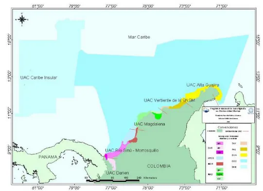
One of the main objectives in coastal delimitations has focused on the management of risk due to environmental hazards. Isolated studies all over the worlds addresses the natural conditions, evolution, and vulnerability of coastal zones to specific hazards, such as shore erosion, sea level rise, storm surge or pollution (Anfuso & Martínez-del-Pozo, 2009; Epifânio, Zêzere, & Neves, 2014; Fitton, Hansom, & Rennie, 2016; Gómez, Ondiviela, Fernández, & Juanes, 2017; Goodhue et al., 2012; Mahapatra, Ratheesh, & Rajawat, 2013; Mcfadden, 2010; Newton & Weichselgartner, 2014; Rangel-Buitrago & Anfuso, 2015; Satta, Snoussi, Puddu, Flayou, & Hout, 2016; Torresan, Critto, Rizzi, & Marcomini, 2012). However, these studies do not address the void of practical knowledge for supporting the environmental assessment of projects and leave aside the adverse effect generated by human interventions. Therefore, the environmental zoning of the coastal zone is a pertinent approach for addressing impact management issues. And this approach should recognize the particularities of the coastal landforms, which is given by the configuration of both emerged and submerged features.In Colombia, the coastal environmental zoning was first introduced by the environmental national policy for the sustainable development of oceanic areas and coastal and insular zones of Colombia (MMA, 2000). This policy establishes three regions subdivided into 12 environmental units, ten coastal and other two oceanic, regarding the jurisdictional waters beyond the isobaths of 200 meters (see Figures ii and iii). Thus, the Caribbean insular region comprehends one coastal unit, the Caribbean continental region comprises five coastal and one oceanic, and the Pacific region contains four coastal units and one oceanic.
31
Figure iii. Environmental units of the Colombian Pacific region. Taken from MMA (2000)
Based in this policy, the Decree 1120 of 2013 made official the environmental zoning of the ten coastal units to make progress toward their integrated management throughout structured plans, called POMIUAC by the Spanish acronym (integrated management and order plan of coastal environmental units). The delimitation is declared to be based on distinctive ecosystems with similar structural connectivity and functionality. In this regulation, the coastal zone boundaries are set at two kilometers inland from the shoreline, transition vegetation or lagoon flooding mark, and until the 200 meters isobaths in the sea. The boundaries along the shore are normally set by a physical pattern, such as rivers.
Justification
32
areas to natural threats of marine or terrestrial origin (Botero, Anfuso, Rangel-Buitrago, & Correa, 2013; Stancheva et al., 2011). Thus, unplanned territorial development represents a challenge for risk management and entails high costs of social and environmental protection for coastal populations and settlements (Cooper, Anfuso, & Rio, 2009; INVEMAR, 2003).There are several studies at local and regional scales about the natural conditions of the Colombian Caribbean coast, its evolution and its vulnerability to specific hazards, such as sea level rise (DIMAR-CIOH, 2009a, 2009b, 2013; IDEAM, 2001; INVEMAR, 2003). These studies have focused mainly on natural hazards, leaving aside the adverse effect generated by human interventions, or considering it only as one more element in the general vulnerability assessment. However, the holistic perspective of the XXI century imposes the need to study beyond merely one-way of the effects, which includes the interactions nature-mankind addressed by the Anthropocene epoch.
In terms of environmental impact, the concept of vulnerability has been used to describe the physical, biotic and social susceptibility of natural systems to damages or threats by the construction, operation or decommissioning of projects, built structures or activities (Toro, Duarte, Requena, & Zamorano, 2012). Therefore, it is pertinent to focus the analysis of physical-biotic susceptibility of littoral areas against the effects of coastal interventions, so that environmental licensing processes have a conceptual and methodological reference to reduce subjectivity in the environmental assessment regulated in Colombia. Thus, this research focuses on the approach of physical-biotic susceptibility, not on coastal vulnerability, because the socio-economic dimension is beyond the direct reach of Earth Sciences.
iii.
Study area, hypothesis, and objectives
33
The thesis is motivated by the situation in theColombian Caribbean, where different types of coastal projects and activities have derived in negative effects, associated with littoral instability and generalized degradation of physical-biotic conditions. The major geomorphological changes aforementioned suggest an inadequate environmental evaluation, monitoring, and control of human interventions. These functions are sorted through the environmental licensing procedure (ELP), which in Colombia is implemented by national and regional environmental authorities (Law 99 from 1993). Therefore, the following hypothesis arises: Colombian environmental regulatory framework is insufficient for managing the effect of human interventions in coastal environments from a geomorphological perspective.
This statement suggests the following research questions: What elements of environmental licensing in coastal environments can be improved from a geomorphological perspective? How the environmental regulatory system in Colombia has evolved regarding the human interventions influencing the coastal environment? What technical improvements can be made in the Colombian regulatory framework to guide the impact assessment, monitoring, and control of human interventions from a geomorphological susceptibility approach?
The general objective of this thesis is to propose adjustments to the Colombian environmental licensing procedure to guide the evaluation, monitoring, and control of human impacts from a coastal geomorphological approach of susceptibility. To reach this goal, the general methodology of the thesis relies on the holistic cycle of scientific research with a quantic process, according to Hurtado
34
(2010). Therefore, each chapter of the thesis contributes to the main goal through the exploratory, descriptive, analytical, comparative, explicative and proactive research stages (see Figure iv).The specific objective achieved by chapters I and III is to characterize the geomorphological settings and human interventions in the continental Caribbean coast of Colombia. The first chapter registers the results of exploratory and descriptive research stages, in which the historical-geomorphological changes of the Colombian coasts are analyzed. Similarly, the third chapter consolidates a baseline of the environmental impact of the continental Caribbean coast of Colombia through an inventory of human interventions, which correspond to a descriptive stage of the holistic research cycle.
The specific objective achieved by chapter II is to identify the geomorphological perspective in the Colombian ELP through the comparison with foreign environmental regulatory frameworks. This chapter represents the comparative research stage to assess the environmental regulatory framework of three countries (Italy, Spain, and Cuba) as opposed to the Colombian one.
The specific objective achieved by chapter IV is to assess the scope of the Colombian regulatory framework according to the environmental licensing of interventions affecting the coastal zone. As an analytical research stage, this chapter correlates the coastal policies and EIA regulations with the inventory of human interventions, to ascertain the limitations and weaknesses of the Colombian ELP.
Finally, the specific objective achieved by chapter V is to establish a conceptual and methodological approach to guide the Colombian environmental licensing procedure in coastal environments from a geomorphological perspective. This chapter relies on two stages of the holistic research cycle. On the one hand, the conceptual approach of susceptibility to the effect of human interventions for environmental licensing purposes results from an explanatory stage. On the other hand, the methodological approach of this conceptual model and its application to the ECU Mag-Dique represents the proactive research stage.
iv.
Critical analysis of the background
Geomorphology and environmental management
35
demand on geomorphological services in terms of tools for evaluating the effects of human activities on geomorphological features (Panizza, 1996b). Therefore, there is a close relationship between geomorphology and EIA despite the superficial interest that the Earth Sciences community has traditionally put on the general environment (Cendrero, Marchetti, Panizza, & Rivas, 2001).In a quick revision, the literature addressing the role of geomorphology in the EIA seems rather limited (Downs & Booth, 2011). A relevant conceptual referent in these regards dates back nearly two decades when Cendrero et al. (2001) differentiate landforms from processes among the geomorphological components that need to be identified in an EIA. According to this argument, the characterization of landforms leads to defining the direct impact of one human intervention in terms of environmental damage or economic loss of natural assets; meanwhile, the processes characterize the damage to a human development due to geological hazards. In other words, landforms play a passive role because they are being threatened by human activity, but the processes play an active role because they set risks to projects or activities. However, this traditional approach also states that processes produce landforms (Panizza, 1996b), which implies that processes play both passive and active roles regardless of the relationship direction between human activity and geomorphological features. Therefore, the natural processes are the backbone of the role geomorphology plays on environmental management issues.
In the main, the geomorphology discipline has played an important role in the general evolution of the EIA. For instance, one of the first process-based studies on the human role on land transformation is with Leopold (1956), which turned out to be one of the seminal referents about the management application of geomorphology in the 20th century (Downs & Booth, 2011). What is more interesting is
how the same author led a proposal from the U.S. Geological Service to homogenize the preparation of environmental impact statements (EIS) or reports required from the authority about the effects of a project (Leopold et al., 1971). This procedure was conceived to improve uniformity in the impact’s analysis between report generators and evaluators through a system of matrixes crossing natural factors and project’s activities. Even though this method is still being thought as a multidisciplinary approach in EIA guidelines, it is basically a contribution from the geomorphology discipline, born and raised in the core of a geological service.
Coastal Geomorphology and the natural processes