1
Strategies For The Recovery Of Threatened Natural Systems
And Their Role In The Mitigation Of Rapid Urban Growth In
Montes De Oca, Costa Rica
Laura Chaverri Flores
a,b, Luis Solano Monge
aaUniversity of Costa Rica, San Pedro, Montes de Oca, Costa Rica bTecnological Institute of Costa Rica, Barrio Amón, San José, Costa Rica
Abstract
Costa Rica is well known for its ecological and landscape diversity. Nevertheless, most of its cities have lost their natural richness due to uncontrolled growth in infrastructure. Urban development has caused surface waterproofing, air and water pollution, poorer landscape quality and a major loss of most native forests and the species living within them. This is the case of the county of Montes de Oca, birthplace of the most important university in the country.
The main campus of the University of Costa Rica comprises nearly 87 hectares and has
conditioned urban growth in the area. It represents one of the few “green lungs” of the
Metropolitan Region and is constantly being threatened by the construction of new buildings. This highlights the urgent need of an urban and landscape development plan. For this reason we made a proposal for its protection, focused on natural continuity, cushioning, ecological compensation and anticipation of future university expansion.
The landscape diagnosis analyzed water resources, slopes, runoff, flora and fauna. In 2017, the
effects of “El Niño”, caused prolonged droughts and heavy rainfall in short periods of time,
which resulted in flooding, high soil saturation and an increased risk of landslides. Green cover in the county is made up of patches of secondary forests linked to the University and
Torres River, urban parks and isolated gardens. At “Finca 3”, the forest fragments represent at
least 26% of the land. A detailed survey of its flora allowed us to characterize trees by shape, dimensions, color, as well as detecting the scarce, native, threatened species and the ones at risk of extinction to define the conservation criteria. We identified 209 tree species on 34 hectares, surpassing the records of larger nearby protected areas famous for their biodiversity, such as Cerros de La Carpintera (110 tree species in 2391 hectares).
At a regional level, we propose the integration of a green infrastructure network, through river corridors and landscape connectors associated with the rivers, linking natural spaces. Therefore, creating animal and plant crossings, nurturing ecosystem services such as carbon fixation and water quality improvement, and promoting outdoor recreation and the prevention of floods and landslides.
factors; the Border System, which analyzes the relationship with the context, adding defined accesses and cushioning fringes; the Functional Units System, which groups homogeneous elements with defined identities; and finally, the Conservation and Ecology System, which promotes ecological and landscape connectivity through two components: water and vegetation. Green infrastructure acts as a natural public health system, favoring physical activity, establishing a bridge that unites forest patches and boosts ecosystem services responsible for preventing climate change. In order to mitigate flooding, there is a chain of lagoons in which water moves by gravity, accompanied by canals and rain gardens that delay water speed, improve its quality and enriches the user experience.
3 1. Introduction
Costa Rica is internationally recognized for its extensive ecological biodiversity, as well for the beauty and variety of its natural and cultural landscapes. Its strategic location as a bridge between North and South America and its altitudinal fringes make it possible to combine landscapes from the humid tropical forest to dry tropical forest. In addition, since the end of the 20th century, the creation of the
National System of Conservation Areas (SINAC), has helped recover part of the
country’s forested area. According to SINAC [1], Costa Rica possesses 26.5% of the continental territory under state protection. However, parallel to the efforts of conservation of the natural patrimony, there has been uncontrolled urban growth in the Great Metropolitan Area (GAM) of the
Central Valley that embodies the
contradiction between an environmental discourse and a chaotic urban reality.
The county of Montes de Oca in the province of San José is one of the urban territories that has undergone a rapid transformation due to urban growth in recent decades. The county is considered the cradle of education in the country since it is home to a multitude of universities. The sparsely controlled growth and demand for buildable space have caused soils in aquifer recharge zones to become impermeable, increased pollution of streams and rivers; and have contributed to the loss of large quantities of forest.
The Rodrigo Facio headquarters of the University of Costa Rica (UCR) created in the
1940’s has also contributed heavily to the urban growth of the area due to its constant expansion with the acquisition of new land
(Fig.1). The campus, from its
conceptualization in the first overall design, was presented as an ECO-CAMPUS boasting
a high percentage of green areas and protected forests, which is why it represents one of the few urban lungs left east of the GAM, and which in turn has been threatened by the construction of new buildings surrounding university spaces. Users as well as university authorities have made known the urgent need for a territorial urban landscape plan for both the campus and adjacent districts. This is why the proposal for the protection of the
Rodrigo Facio headquarters was
developed, replicable in other areas of the city, emphasizing the importance of the
continuity of “green infrastructure” and of
various natural layers superimposed upon urban use. This article presents a diagnosis of the area and proposes strategies for the recovery of threatened natural systems and the mitigation of urban growth within the Campus and the surrounding extent of Montes de Oca.
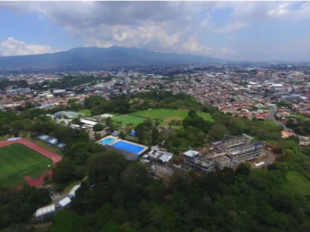
Fig. 1. Campus and Montes de Oca Context. Source: Paul Vega Salas (2017). LANAMME.
2. Methodology
citizen participation with tools including flowcharts or evaluation sheets, it was possible to make a perceptual social diagnosis. Additionally, mobility, spatiality, the landscape and its natural systems were diagnosed along with the new buildings that are intended to be built at the University. For each diagnosis, their current situation and problems were analyzed to produced recommendations and guidelines for planning.
In this article, we will focus on the analysis of landscape and natural systems. For this process it was necessary to conduct field work in transdisciplinary teams. A thorough survey
of the campus’ vegetation was conducted considering native and exotic species, deforested and newly sown trees, as well plant
habitats. Examining historical aerial
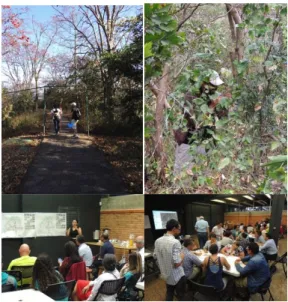
photographs and previous analyses made it possible to truly grasp the magnitude of the loss of forest cover and predominant urban expansion in the area. On the other hand, maps of the county were created emphasizing the area of the Torres River Biological Corridor according to maps of the Environmental Fragility Index of the National Electric Company (CNF). Finally, the information from the different diagnoses was cross-linked in order to generate mitigation guidelines and a landscape proposal. For this phase two participatory workshops were held: one with university personnel and another with surrounding neighbors and urban groups in the area (Fig. 2). We worked in a variety of scales framing the campus within its respective county, as well as the scale of the Rodrigo Facio headquarters in the University and other specific areas of the Campus.
Fig. 2. Field work and participatory workshops. Source: Own elaboration (2017).
3. Territorial framing
3.1.Montes de Oca
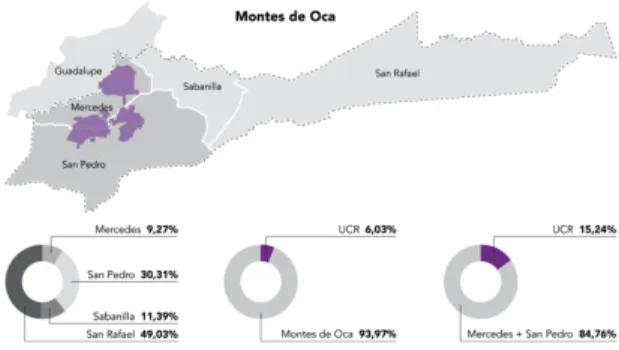
The county of Montes de Oca consists of 15,6 km2 and is composed of 4 districts,
San Pedro (4.82 km2), Sabanilla (1,79
km2), Mercedes (1,39 km2), and San
Rafael (7,16 km2). San Pedro occupies
30% of the territory and is the second most densely populated district following Sabanilla, with 52% of the population while San Rafael only has 15.3% of the population and a large part of the protected forest area [2]. The Rodrigo Facio Headquarters of UCR holds nearly 87 hectares, occupying 15.24% of the territory of two of the districts in the county of Montes de Oca (Fig. 3). This county adjoins the northwest with the county of Guadalupe, the Torres River becoming a
boundary or “back” instead of a blue
5 Fig. 3. Location of UCR in Montes de Oca + territorial extension relationship. Source: Own elaboration (2017).
3.2.Impact of the University of Costa Rica in the county the expansion of the campus has enhanced the creation of services, commercial areas, rental housing for university students and a series of universities and educational institutions that are established nearby, increasing the educational vocation. As result, this has generated increased land value, causing displacement of permanent housing areas, the disappearance of traditional neighborhoods, coffee plantations and the remnants of riparian forests, producing a deterioration in landscape quality.
3.3.The Interurban Biological Corridor
Given the growing demand for built space, the system of green areas in the county has been drastically affected, decreasing urban parks and recreational areas. This is why rivers have
reemerged, formerly invisible as an
opportunity to protect biodiversity; as a strategy for the articulation of their scope of protection with small green patches, parks or
forests scattered around the city,
generating connectors that support
continuity throughout the city and allow the transit of populations of flora and fauna established in these sites.
The Interurban Biological Corridor of the Torres River (Fig. 4) is an initiative led by the Hydrographic Basins and Biological Corridors Program of the municipality of San José with the support of other organized groups of neighbors and professionals. This project seeks to rehabilitate the protected areas, protect the urban environment and establish itself as the first urban ecological corridor in the county. Through the initiative, different ecosystem services would be obtained; defined as the benefits that humans obtain from natural ecosystems such as provisioning (obtaining water, food and natural resources); regulation (regulating floods and droughts); cultural (promoting spiritual values); and support [3].
The territory of UCR limits its northwest margin with part of this corridor along 745 m and restricts it to “Fincas” 3 and 4 with their margins of 33.667 m2 that must be
exclusively deemed riparian protection areas. This strip presents a great widening of the vegetal coverage in relation to the context for its vulnerability evidences even more the importance of protecting these tracks inside the university campus.
4. Diagnosis of Landscape and Natural Systems
As we have seen throughout this article, the Torres River Interurban Corridor, still protects an important segment of forest in contrast to the rest of the county and potentially allows the east-west articulation of strategic sites such as the Park of the East, the UCR, the Simon Bolivar Park and the Children's Museum. Within this dynamic UCR holds a relevant role in its consideration as a lung within the urban system for its density of plant cover, a condition that influences the surrounding natural landscape (Fig. 5).
Fig. 5. Location of Montes De Oca. Source: Own elaboration, based on Google Earth photo (2017).
The landscape analysis carried out considered a systemic approach, where the territory is understood as a complex relationship of articulated systems, for its study a superposition of variables combined with the cartography was proposed so that each component analyzed could be reflected in maps and identified within the system. In relation to this diagnosis, the following were analyzed: water resources and runoff, topography, as well as flora and fauna.
4.1.Slopes
At the topographic level, the county presents a very marked difference to the eastern sector, covering the San Rafael district. In this sector the slopes increase, becoming greater than 20% [4], due to the presence of mountains that are extensions to the faults of the Irazú Volcano, also generating the appearance of numerous rivers and streams (Fig. 6). On the other hand, towards the western sector the topography is more consistent except for some river basins that are forming mountains and occupy more depth in the area.
7
The central zone of the Sports Facilities and F4 has a more consistent topography with slopes ranging from 2.5 to 5% and up to 10%, where most buildings and infrastructure have been built. As one moves away from this central heart, the topography becomes more irregular responding to the different water channels that cross it, increasing the slopes from 10, 20 and up to 40% in the margins of the rivers. Through certain depressions, visual basins are also formed that allow observing the urban center in the distance (Fig. 6).
4.2.Hydric Resources
Fig. 7. Maps of the rivers in the county + Sports Facilities and F4, UCR. Source: Own elaboration (2017).
Within Costa Rica in 2017, the El Niño
phenomenon generated significant
variations in precipitation, causing
shortages of rain on the Pacific slope and excess in the Caribbean. Although the fluvial system of the county of Montes de Oca belongs to the Pacific slope, torrential rains occurred, generating serious flood problems. The topography of the county with mountains that descend towards the populated sectors (Fig. 7), added to the loss of vegetation cover, pollution, possible earthquakes and saturation of soils and riverbeds. These factors increase events such as floods and landslides in urban areas.
At the campus scale, a study of directionality of surface runoff from the topography and slopes defined that most of the runoff vents to the surrounding rivers and streams, contributing to considerable
water volumes. Some regulatory
withdrawals such as those required for rivers that vary from 10m to 50m or the 100m perimeters for the springs restrict the construction of buildings for the protection of these water bodies, however sometimes these containment strips are not enough.
4.3.Wildlife, vegetation and forest cover
As for the system of life zones, Montes de Oca is composed of the Very Humid Premontane Forest in the eastern regions and the Montane Low Humid Forest in the middle section. The districts of San Pedro, Mercedes and Sabanilla are mostly part of the Premontane Humid Forest (Fig. 8), which has been reduced to small representative patches within the city due to deforestation and urban growth.
and the Torres River (Fig. 8). In the high zones of San Rafael the intervened forests abound and throughout the county exist various urban parks, vacant lots and isolated gardens, with certain vegetative wealth.
Fig. 8. Life Zones + Forest and green areas Maps. Source: Own elaboration, based on maps of Fragility Index (2017).
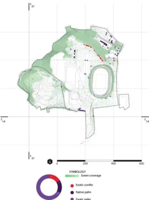
Fig. 9. Maps of native and exotic trees + confers and palms. Source: Own elaboration (2017).
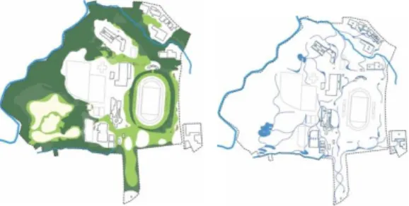
The Campus density study shows areas of high plant density correlate with bodies of water. The Campus has protected areas and
a botanical garden in Plot 1. In “Finca” 3,
for example, the forest patch represents 26% of the land. A detailed study of the flora of the site was made, categorizing the outstanding trees by form, monumental size, those possessing striking color, as well as native and exotic species. In addition, a meticulous survey of scarce and native trees, as well as threatened and
endangered trees, clarified the
conservation criteria of the species, detecting logging without planning in recent years. We identified 1,090 (59%) native trees and 510 (27%) exotic trees (Fig. 9). Of the native trees, 123 different
species were identified in “Finca” 3 and
9
and recognized for their biodiversity, such as La Carpintera (2.391 ha with 110 species). While the native trees predominate in the election of zingiberals, conifers and shrubs, exotic species prevail, a frequent phenomenon in the selection of urban species within the the Campus represents an important contribution in CO2 capture, emitting 4,538 tons and capturing 56,219 [5]. In addition, the high level of appreciation that the community has regarding its natural areas is evident with participatory tools.
4.4.Conclusions and Issue
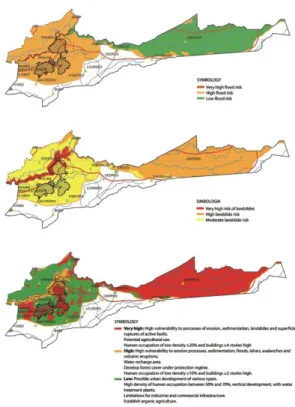
Fig. 10. Maps of flood risks + landslides. Below: Maps of integrated
IFA’s, zones of vulnerability. Source: Own elaboration, based on maps from the Environmental Fragility Index of CNFL (2017).
The irregular topographic condition of the county, with steeper slopes, produces numerous river channels that descend into urban areas. The pressure on its protection margins added to the loss of coverage, waterproofing and direct outflows increase risk conditions (Fig. 10). It was discovered that the different existing natural and water systems have degraded over time and continued urban expansion is generating natural dilemmas within the city. The need to produce new systems that are more strongly integrated with nature is imperative.
5. Results: Strategies for recovery
Biophilia is the deep-seated need of humans to connect with nature [6]. A biophilic city is at its heart a biodiverse city, a city full of nature, a place where in the normal course of work and play and life residents feel, see, and experience rich nature-plants, trees, animals [7].
At the regional scale, the protection of water resources and the incorporation of green infrastructure that connects urban parks and
the area’s most important green spaces are proposed. Emphasis is placed on the protection of aquifers located in elevated areas. Likewise, different green and landscape corridors are established along the two main rivers: the Torres and María Aguilar rivers, creating several linear parks, as well as regeneration parks that make up a large metropolitan river corridor. These corridors that act as pathways for animal and plant life, also provide ecological services such as carbon capture, water quality control, prevention of floods and landslides, recreation and sports areas, among others. The metropolitan park, La Sabana, and the University Campus function as excellent articulators between these two rivers (Fig. 11).
From the Campus scale, prototypes are proposed on a smaller scale that can serve as an example in the management and protection of corridors incorporating water sanitation, articulation of green patches and landscape and ecological integration within the urban context; schemes replicable in other potential sectors along the corridors.
Fig. 11. Macro proposal maps. Source: Own elaboration based on Google Earth, Torres River Biological Park Articulator (Laura Chaverri), Rutas Naturbanas and (2017).
5.1.Proposed systems
The proposal is based on four different systems vital to the Campus, which are interdependent, focused on achieving a balance between the current condition and the
future development of buildings
complemented by green areas to minimize their vulnerability.
The first, the Articulation System; resolves the connection of the Campus with its surroundings taking into account
the pedestrian, cyclist, public
transportation lines and private vehicles in a balanced system for each user. The Edge System studies the relationship of the
Campus with the environment,
incorporating well-defined access in some areas and incorporating a buffer layer in others. The system of Functional Units corresponds to the configuration of spaces with defined identities that group buildings and green areas producing small sets linked by the “articulator” system. Finally, the backbone of the proposal is formed by the Protection and Ecology System focused on facilitating ecological and
passive connectivity through the
reinforcement of the "green and blue infrastructure" (Fig. 12).
11
runoff caused by storms and the generation of increased biodiversity. Likewise, trees with high maintenance and conservation priority are defined, according to the diagnostic criteria.
To compensate for the serious problem of flooding both on the campus and in the surrounding areas, an interconnected water system consisting of channels, compensation and macrophyte ponds, and rain gardens is proposed, which delays the speed of water evacuation and thus the pollution of the rivers by means of oils and hydrocarbons that were not previously treated. A new evacuation system is proposed with a succession of ponds that circulate by gravity towards the river, thus improving water quality and the experience of visitors.
Fig. 12. Layers structure diagram. Source: Own elaboration (2017).
Fig. 13. Green and blue Infrastructure diagram. Source: Own elaboration (2017).
Fig.14. Proposed urban section showing F3 UCR and integration with Cartaga public street. Source: Own elaboration (2017).
Fig.15. Protection and Ecology System in the Campus. Source: Own elaboration (2017).
6. Conclusion
Throughout the article it was possible to observe the enormous landscape and ecological potential possessed by Montes de Oca, however we also detect many problems that must be solved. For the proposal, different design principles were used, where connectivity, education and diversity stand out, as well as biophilic design patterns as visual and non visual connections with nature and the presence of water. The proposal focused on ensuring a sense of identity by strengthening the ecological vision and demonstrating that it provides enormous benefits to the human population, such as offering an ideal environment for relaxation or providing water purification services. Biophilic design patterns have the potential to
re-position the environmental quality
conversation to give the individual’s needs
equal consideration alongside conventional parameters for building performance that have historically excluded health and well-being [6].
Although this work has been well accepted by university authorities and neighbors who were invited to both workshops and the presentation of results, it is essential to be able to execute some of these proposals in order to generate a real user impact. It is imperative to involve local governments and communities in order for concrete actions to be carried out in our cities.
Acknowledgments
It must be recognized that the extended research and design work was carried out by a multidisciplinary team consisting of: Arch. Laura Chaverri (project director), Arch. Guillermo Chaves, Arch. Luis Solano, Arch. Nancy Corrales, Arch. Fernanda Barquero,
Bio. Carlos Bolaños, Luis Fuentes, Sigrith Solera, Karen Badilla and Roberto Hidalgo.
We thank the Rector's Office and the Architecture School of the UCR, as well as the Architecture and Urbanism School of the Technological Institute of Costa Rica for the support provided to carry out this
[1] SINAC (Sistema Nacional de Áreas de Conservación), Plan Estratégico Sistema Nacional de Conservación SINAC, San José, Costa Rica, (2010) 64.
[2] Municipalidad de Montes de Oca. Información poblacional. http://montesdeoca.go.cr/index.php?option=com_content&
view=article&id=136:informacion-poblacional&catid=12:datos-generales&Itemid=254 (accessed March 20, 2018).
[3] M. Polo, Revista Investigación Ambiental Ciencia y Política. 6 (2014) 47.
[4] PRODUS (Programa de Investigación en Desarrollo Urbano Sostenible), Diagnóstico Uso del Suelo (2001) 15. [5] E. Muñoz, (Octubre 30, 2013). UCR aspira a carbono
neutralidad en 2020.
https://www.ucr.ac.cr/noticias/2013/10/30/ucr-aspira-a-carbono-neutralidad-en-2020.html (accessed March 19, 2018).
[6] C. O. Ryan, W. D. Browning, J. O. Clancy, S. L. Andrews, N. B. Kallianpurkar, Journal of Architectural Research. 8 (2014) 62-76.