Aspects of implicit and explicit human
interactions with ubiquitous geographic
information
Fabien Girardin
TESI DOCTORAL UPF / 2009
DIRECTOR DE LA TESI
Acknowledgments
This PhD thesis would not have been possible without the support and collaboration of many people.
Firstly, I would like to acknowledge my supervisor, Josep Blat, who throughout the course of this project provided me with constructive advices and timely guidance. I wholeheartedly thank him for his invaluable knowledge, and all the opportunities that made me gain academic experience.
This journey to a PhD led me to collaborate with different research laboratories besides the Interactive Technology Group (GTI). I am grateful to Prof. Carlo Ratti who hosted me in his SENSEable City Lab at the Massachusetts Institute of Technology and to Prof. Pierre Dillenbourg who gave me the confidence to reach higher when collaborating with him at CRAFT within the Swiss Federal Institute of Technology in Lausanne. I particularly owe many hours of hard work to my colleagues in these different research laboratories. Our interdisciplinary work enlarged my horizons with new skills and new languages.
My colleague and friend Nicolas Nova played a fundamental role in helping me reach my goals to the completion of this thesis through constant discussions and encouragements. A number of other people have generously let me pick their brains or commented the work reported. Thanks to Steve Benford, Barry Brown, Matthew Chalmers, Mauro Cherubini, Assaf Biderman, Julian Bleecker, Luc Girardin, Adam Greenfield, Liang Liu, Ayman Moghnieh, Toni Navarrete, Raquel Navarro, Tom Rodden, Jonathan Raper, Mirweis Sangin, Sergio Sayago, Daniel K. Schneider, Andrea Vaccari and the 7.5th Floor blog readers for the conversations about this work.
I am grateful to those who generously took time to participate in the studies reported here.
Abstract
Resumen
Preface
The digitization of our lives with technologies embedded into the streets and buildings and carried by people and vehicles has appended an informational membrane, hovering over the physical space. This situation is exemplified by novel human practices that involve replying to a text message to confirm the location of a meeting, briefly working on a laptop, being lost and using Google Maps, relying on real-time traffic information to select a route, or sharing photos of a recent trip on the Web. This ubiquitous presence of information is beginning to profondly affect the way people live and feel their environment.
These changes calls for an exploration of the implication of this recent widespread of mobile and location-sensing technologies and the geoinformation they generate and make available. The possibilities offered by them are enormous, from the new capabilities to index and communicate meaningful personal experiences, reveal urban dynamics to the suggestions of a driving itinerary in an unknown territory. However, there is still very little understanding on how human interact with this ubiquitous geographic information. This thesis starts filling this gap. It explores some important aspects of these interactions through five complementary case studies.
The articles selected for inclusion in this dissertation represent only a fraction of the publications produced for this thesis. The following is a partial list of the remaining first authored papers published.1 They are sorted in reverse-chronological order:
Girardin, F., Vaccari, A., Gerber, A., Biderman, A., and Ratti, C. (2009). Towards estimating the presence of visitors from the aggregate mobile phone network activity they generate. In 11th International Conference on Computers in Urban Planning and Urban Management.
1 Available for bulk download at:
Girardin, F., Vaccari, A., and Ratti, C. (2008). Uncovering the presence and movements of tourist from user-generated content. In 9th International Forum on Tourism Statistics, Paris, France. Girardin, F., Blat, J. (2008). Assessing pervasive user-generated
content to describe tourist dynamics. In First International Workshop on Trends in Pervasive and Ubiquitous Geotechnology and Geoinformation, Park City, USA, September 23, 2008
Girardin, F. and Blat, J. (2008). The co-evolution of taxi drivers and their in-car navigation systems. Situating Sat Nav session at the 2008 Association of American Geographers Annual Meeting, April 2008.
Girardin, F. (2007). Towards reducing the social-technical gap in location-aware computing. Master of Philosophy thesis, Universitat Pompeu Fabra.
Girardin, F., Fiore, F. D., Blat, J., and Ratti, C. (2007). Understanding of tourist dynamics from explicitly disclosed location information. In 4th International Symposium on LBS and Telecartography, Hong-Kong, China.
Girardin, F. and Blat, J. (2007). Place this photo on a map: A study of explicit disclosure of location information. Late Breaking Result at Ubicomp 2007.
Girardin, F. (2007). Bridging the social-technical gap in location-aware computing, Doctoral Colloquium at Pervasive 2007, Toronto, Canada.
Girardin, F. (2007). Bridging the social-technical gap in location-aware computing. In CHI ’07: CHI ’07 extended abstracts on Human factors in computing systems, pages 1653–1656, New York, NY, USA. ACM Press.
Girardin, F., Nova, N., Blat, J. (2006). Towards Design Strategies to Deal with Spatial Uncertainty in Location-Aware Systems, Poster at Ubicomp 2006, Orange County, CA. USA.
Development Infrastructures, Barcelona, Spain, June 21-22, 2007.
Girardin, F., Boursinou, E., Moghnieh, A. (2007). “Convince Woody”, a serious game on competence development in a distributed collaborative environment, 2nd TenCompetence Workshop on Service Oriented Approaches and Lifelong Competence Development Infrastructures, January 11-12, 2007, Manchester, UK.
Girardin, F., Blat, J., and Nova, N. (2007). Tracing the visitor’s eye: Using explicitly disclosed location information for urban analysis. IEEE Pervasive Computing, 6(3):55.
Organized workshops
In parallel, I co-organized venues and setup events for researchers and professionals of my domains of investigation to share and discuss their works and thoughts.
Girardin, F., Nova, N., Kaplan, D., (2009), The Design of the Hybrid City of the Near Future, Lift Conference, Geneva, Switzerland, February 25, 2009
Girardin, F. (2008) Real-time Cities, MIT Department of Urban Studies and Planning, Cambridge, MA, USA, April 14, 2008
Nova, N., Girardin, F., Bleecker, J. (2008) Ubiquitous computing: visions, failures and new interaction rituals, Lift Conference, Geneva, Switzerland, February 6, 2008
A blog as a research tool
From March 2003, before my PhD coursework, to April 2009 I published a personal research blog2. It started as an attempt to move my research notebook online to forge new connections and keep track of my thoughts. This blog has proven indispensable as a research method used to communicate my work through about 1400 posts and feedback from 400 comments. It became a research tool, part of general open science movement in which I not only
Contents
Page
Acknowledgments ... iii
Abstract...iv
Resumen ...v
Preface... vii
1. Introduction ...1
2. The generation and user perception of uncertainty in ubiquitous geoinformation ...9
2.1. Methods and participants ...10
2.2. Data collection and analysis ...11
2.3. Replay tool ...11
2.4. Underwhelming effect of automatic location-awareness ...12
2.5. Summary of the contributions ...14
3. The appropriation of ubiquitous geoinformation ...29
4. The human implicit interaction with wireless infrastructures as source of travel detection and survey...55
5. User-generated ubiquitous geoinformation as evidences of tourist dynamics ...77
6. Digital footprints as evidences of urban attractiveness ...117
7. Discussion and perspectives...143
7.1. People as sensors; people as actors ...143
7.2. Discussed summary of the contributions ...144
7.3. Implications for future research ...150
7.4. Concluding remarks ...156
1. Introduction
Current technology requires information to be served from somewhere and delivered to somewhere. Heisenberg’s uncertainty principle not withstanding, at geographic scales a bit always has an associated location in real geographic space. (Goodchild 1997)
The increasing use of mobile, digital and location-sensing technologies such as digital cameras, mobile phones, Global Positioning Systems (GPS), and web-based services in our personal and professional activities is changing our lives, not only in the way we communicate and interact with each other but also how we perceive our environment. We should add to this picture the webs of sensors, which monitor the environment, ourselves as part of this environment through our interactions with these novel infrastructures. Some of these interactions are explicit when a user knowingly operates a system to achieve a certain goal (e.g. use of a navigation system, georeference photos, disclose one’s location). In contrast, others are implicit when the user is not actually aware of them because he or she concentrates on more important activities (e.g. handovers on a wireless network when walking on the street, the log of the originating cellular antenna when making a phone call, driving with a navigation system in passive mode)
through five case studies, which have complementary approaches to the issue (see Figure 1 for an overview).
Figure 1. The articulation of this thesis through diverse case studies and their complementary contribution on human interaction with ubiquitous geoinformation,
One of the main contributions of this thesis is to provide evidences of what Bell and Dourish (2006) refer to as the “ubiquitous computing of the present”. The case studies are part of the paradigm change in the research field, in the form of proving that “ubicomp” is already here, but does not have the form that was envisioned. In consequence, we consider the imperfections of everyday life as a central theme of research in ubiquitous computing, arguing further on the warnings of Bell and Dourish: “The seamlessly interconnected world of future scenarios is at best a misleading vision and at worst a downright dangerous one”.
[image:14.499.89.409.128.301.2]collaboration, the technological boundaries of location-aware systems and the users strategies to overcome the limitations and shortcoming of technologies. The publications on these insights contributed to the “Are we there yet?” discourse that questioned whether ubicomp was something yet to be achieved. Furthermore, this work not only helped to recognize the current impossibility of a completely seamless, invisible, ubicomp infrastructure but also suggested that users adapt to the limitations these technologies. Indeed, the presence of ubiquitous technologies on the streets (Greenfield, 2006) encouraged us in confronting real people in real everyday environments and move beyond the “fake it” environments and missions of so many ubicomp studies. As suggested by Davis et al. (2005): “developing complex system is not a new problem. However, when looking at ubicomp systems, understanding the full complexity is often different and more difficult than in areas of more bounded scope”.
A first aspect of our results framed in a present ubicomp is the convenience of seamful interaction with location-aware devices rather than a seamless one, which is argued from the results of our case study number one (Chapter 2). Based on CatchBob!, the pervasive game we developed, we show that, despite location technologies having a degree of uncertainty, users develop intelligent strategies to cope with it. These strategies are based on understanding the way the technologies imperfectly work. A side, but important, result is that human communication on location can replace the machine sensed one, and this leads to a more immersive experience of the game (involving acts of communication carrying intentions). These findings were revealed with the development of a replay tool that visualizes the players movements and interactions from the logged data and digital messages. However, this experimental approach limited the understanding of the real life interactions, in a wider context, with a wider range of applications, devices and artefacts, common for ubiquitous systems. Our second case study specifically analyzed this aspect.
the uncertainty and different levels of location granularity of the geoinformation. For instance, the individuals with less knowledge of the environment are unable to assess the quality of the information delivered by their location-aware system. Furthermore, we reveal that the automation of the wayfinding process alters the social practices that were at the source of learning the unofficial and provisional city from the interactions with their customers. In reaction, the taxi drivers rely on an ecosystem of complementary sources of city information to support their practice. These findings support that poor geoinformation quality, lack of timeliness and completeness, and inaccuracies challenge users in their decision-making, who handle this with both frustrations and new strategies to manage these situations. These strategies are evidences that reveal the presence of a social-technical gap formed by the discrepancies between the users’ expected granularity of information and what the technology can deliver. In consequence, we interpret these findings to inform the design of location-aware systems. For instance, we suggest a seamful design approach that highlights the quality of the geoinformation instead of hiding it. Furthermore, we describe the implications of automating the disclosure of geoinformation on the user experience with the immersion, learning and social impacts. At a higher level of granularity, this work embraced a broad perspective that argues against the conception of technology as an autonomous, external force imposing societal change. Our focus on everyday practices, experiences, and interpretations of geoinformation gives evidences of a co-evolution in that these location-based systems alter individual’s practice and in return individuals appropriate them in unexpected ways.
behavioural patterns, captured in this case as digital footprints, constitute a powerful unobtrusive alternative to complex technological developments of longitudinal travel surveys. This approach introduces a novel methodology of providing informative indications on human spatial dynamics from processing data sources far more reliable than traditional subjective surveys. However, detecting mobility and travel at a larger scale is difficult due to the challenge of building informative, yet unobtrusive solutions that respect privacy.
Another major contribution of this thesis takes upon that challenge. It builds on our first case study (Chapter 2, visualize logs of digital footprints) and three (Chapter 4, detect mobility from digital footprints) to explore the explicit and implicit digital footprints generated by individuals and groups to reveal their behaviours in space. Our fourth case study (Chapter 5) is a precursory analysis of the massive amounts of information that are being recorded and stored daily about people’s behaviour, as they walk through the streets with their mobile phones, drive their cars and use the Web. This research went along the line of Bruno Latour who foresaw that the consequences of such information for Social Sciences will be enormous: they can finally have access to masses of data that are of the same order of magnitude as that of their older sisters, the natural sciences (Latour, 2007), adding:
I am sure that this accumulation of traces … is worth pointing out. The precise forces that mould our subjectivities and the precise characters that furnish our imaginations are all open to inquiries by the social sciences. It is as if the inner workings of private worlds have been pried open because their inputs and outputs have become thoroughly traceable.
expression of geoinformation in the context of improving interaction. But this explicit information offered even further human traces that could be analyzed to understand human in many ways. We developed new concepts and methods for retrieving, analysing and visualising this information, which offered both geographical and temporal traces of activity. The tools were used to map tourism and non-tourism related behaviour, again going far beyond what has been traditionally coming from surveys, with an unprecedented large scale and with publicly available data. This work shows that innovative developments in spatialization, information visualization, and geovisualization are altering the nature of maps which become more tools for exploring data than static representations for communicating results.
This explicit and voluntary information provides a wealth of results. However, the same explicit character indicates a potential bias that motivated further exploration. Therefore, we combined and compared implicit and explicit digital footprints that visitors leave behind them in Rome, ItalyThe results show that these data sources offer probably complementary aspects, complementary human behaviours, rather than confirming through another data source the initial results, which was our initial assumption.
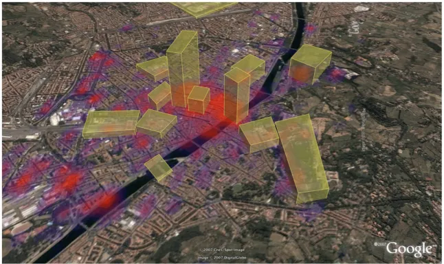
Nevertheless, this work showed that the analysis of these user-generated spatio-temporal data has the potential to supply high-level human behaviour information valuable to urban, travel and tourism studies. In an effort to demonstrate this potential, our fifth case study (Chapter 6) exploits these evidences as indicators of the evolution of the attractiveness of the urban space. The case study took place within a project to quantify the impact of the New York City Waterfalls exhibit on the attractiveness of the waterfront. It was made possible with the development of an interpolation model of network activity to map cellular network statistics. For that objective, we measured the relative density of digital footprints as evidences of the evolution of the attractiveness and popularity of points of interests.
human use and appropriation. It provides answers on the strategies to cope with spatial uncertainty and how this automation of geoinformation delivery alters the social dynamics, the learning process of the environment and human engagement with it. We also explore the massive amount of ubiquitous geoinformation generated through people explicit and implicit interactions with mobile devices and wireless infrastructures. In this context we develop new concepts, tools and techniques to extract the individuals and groups spatial dynamics, while respecting users’ privacy. As a result, we show the applicability of these methods in the domain of market research and urbanism. This thesis dissertation presents these contributions through a compilation of the following articles:
Chapter 2: First case study on “The generation and user perception of uncertainty in ubiquitous geoinformation”.
Girardin, F., Blackstock, M., Dillenbourg, P., Finke, M., Jeffrey, P., Nova, N. (2007). Issues from Deploying a Pervasive Game on Multiple Sites, Common Models and Patterns for Pervasive Computing Workshop, 5th International Conference on Pervasive Computing, May 13, Toronto, Ontario, Canada.
Girardin, F. and Nova, N. (2006). Getting real with ubiquitous computing: the impact of discrepancies on collaboration. e-Minds International Journal on Human-Computer Interaction, 1(1):60–64.
Chapter 3: Second case study on “The appropriation of ubiquitous geoinformation”
Girardin, F. and Blat, J. (Submitted to Pervasive and Mobile Computing Journal). The co-evolution of taxi drivers and their in-car navigation systems.
Chapter 4: Third case study on “The implicit interactions with wireless infrastructures as source of travel detection and survey”.
Girardin, F., Nova, N., and Dillenbourg, P. (Submitted to the
Chapter 5: Fourth case study on “User-generated ubiquitous geoinformation as evidences of tourist dynamics”
Girardin, F., Dal Fiore, F, Ratti, C., and Blat, J. (2008). Leveraging explicitly disclosed location information to understand tourist dynamics: A case study. Journal of Location-Based Services 2(1), 41–54.
Girardin, F., Calabrese, F., Dal Fiore, F. , Ratti, C., and Blat, J. (2008). Digital footprinting: Uncovering tourists with user-generated content. IEEE Pervasive Computing, 7(4):36–43.
Chapter 6: Fifth case study on “Digital footprints as evidences of urban attractiveness”
Girardin, F., Vaccari, A., Gerber, A., Biderman, A., and Ratti, C. (2009). Quantifying urban attractiveness from the distribution and density of digital footprints. International Journal of Spatial Data Infrastructure Research, 4.
2. The generation and user perception of
uncertainty in ubiquitous geoinformation
In this chapter, we report these valuable lessons from experiments based on a pervasive game called CatchBob!. This game was primarily developed as an artefact to explore social and cognitive implications of geolocalisation (see Nova (2007) for extended findings in that context). However, the availability of the CatchBob! platform also led us to investigate other issues, more related to the user experience of ubiquitous geoinformation and the inherent design issues of such platforms (for a discussion of the wide range of aspects, see Nova and Girardin, 2009). In the scope of this thesis, we particularly investigate the different roles played by the technological infrastructure (e.g. wireless access points, web servers, network modules on the mobile devices) as source of uncertainty in ubiquitous geoinformation perceived by the players. Indeed, building ubiquitous applications that exploit location requires integrating underlying infrastructure for linking sensors with high-level representation of the measured space to produce a pleasant user experience. However, the real-world constraints limit the efficiency of location technologies. An inherent spatial uncertainty embedded in mobile and location systems creates a social-technical gap that constantly challenges the coexistence of digital and physical spaces. In the context of CatchBob!, we were able to highlight that the quality of the ubiquitous geoinformation influences the user experience and the infrastructures must be consciously attended, as they are unevenly distributed, unevenly available.
This chapter includes papers that discuss the sources of spatial uncertainty, the perception of uncertainty and contextualize these findings within this research work in ubiquitous computing:
Girardin, F., Blackstock, M., Dillenbourg, P., Finke, M., Jeffrey, P., Nova, N. (2007). Issues from Deploying a Pervasive Game on Multiple Sites,
Girardin, F. and Nova, N. (2006). Getting real with ubiquitous computing: the impact of discrepancies on collaboration. e-Minds International Journal on Human-Computer Interaction, 1(1):60–64.
However, as these papers have been published at the early stage of this thesis, they do not report on some valuable elements with regard to the user experience of ubiquitous geoinformation. We believe it is particularly worthy describing more in depth the research method as well as the contributions on the underwhelming effect of automatic location awareness and the ability to replay the players path.
2.1. Methods and participants
Players were recruited in teams of three, which led to a total of 30 teams and 90 players. The games were set up so that no teams played at the same time. The participants were all between 19 and 28 with a mean age of 23.1. More male than female players signed up, so teams were generally made up of two males and one female. Most were students from different disciplines (biology, mechanical engineering, computer sciences, architecture). Participants spoke either French or English but they used the same language within a group.
2.2. Data collection and analysis
Data on the players’ activity was collected via system logging and semi-structured interviews. Data logging captured all movements in space as well as players’ communication through map annotations (content, moment of exchange). This logging allowed us to uncover the spatial strategies and review the discussion that led to their implementation. They were also compared to the discussion in the planning phase that we also recorded. The post-game semi-structured interviews were meant to elicit the players strategies, the implementation of the decided strategy (and how they reshaped it) and all the problems they had during the game.
The questions further probed the participants’ experience with the application (communication and location-awareness feature); what elements of the environment they relied on to play the game; and how they experienced the game setting (activity, exploration of space, coordination tactics). A replay tool displayed in real time the position of each group member, as well as their annotations. Those traces of the activity were presented to help players in giving an account of what happened, an interview technique known as self-confrontation.
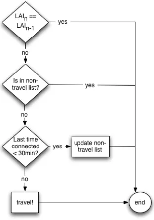
2.3. Replay tool
issues of the ubiquitous infrastructures. It typically requires one of the tool developers to be present during replay and analysis. This experience was at the source of the development of the algorithm that detects air travels from the mobile devices interactions with spotty wireless infrastructures, as presented in our third case study (Chapter 4).
Figure 2. Screenshot of the Replay tool that displays the path of the three players from their positions.
2.4. Underwhelming effect of automatic
location-awareness
The papers presented in this paper describe how the combination of both logging and interview data helped to give us a rich picture of how the spatial environment of the game was not uniform and homogeneous. However, as reported in Nova et al. (2006) another elements of the effect of automatic disclosure of location information (i.e. location-awareness) is worth reporting.
on the interface. NoMLA participants could only see the update of their own location. These two experimental setting conditions allowed us to test the influence of location-awareness on collaboration. This field experiments illustrate that the following:
• An underwhelming effect of mutual location-awareness on
players’ mutual representations: participants in the NoMLA groups better recalled their partner’s movement in space than participants in the MLA groups. The main reason is that participants in the NoMLA groups compensate for the lack of information about others’ location in space by sending map annotations. Since self-reported location information was only sent when it made sense to the participants, it seemed that the players more effectively internalized them (see Nova, 2007 for a complete description).
• An underwhelming effect of mutual location-awareness on players’ communication: the location-awareness feature not only lowered the exchange of messages about location (which is logical), it also diminished communication about strategy and direction issues.
• Players in the “NoMLA” groups took better advantage of the annotation capabilities, using annotation to express their location, their path and their strategy. The players with the awareness tool were able to annotate as well but did not use this capability.
2.5. Summary of the contributions
In summary, this case study contributes to bthese issues with:
• Guidelines from the lessons learned from the deployment of
a collaborative pervasive game on two different sites. We emphasize on the practical aspects of getting a pervasive system deployed without any extra special infrastructure;
• Users of ubiquitous technologies often react to spatial uncertainty due to systems’ limitations;
• Categories of reactions to spatial uncertainty;
• Design of a tool to replay players path from their logged
interactions with the wireless infrastructure;
• Automating location-awareness can be detrimental to group
Issues from Deploying and Maintaining a Pervasive
Game on Multiple Sites
Fabien Girardin1, Michael Blackstock2, Pierre Dillenbourg3, Matt Finke2,
Phillip Jeffrey2, Nicolas Nova3
1 Pompeu Fabra University, Passeig de Circumval·ació, 8,
08003 Barcelona, Spain [email protected]
2 Department of Computer Science, University of British Columbia,
201-2366 Main Mall, Vancouver, Canada [email protected]
3 Swiss Federal Institute of Technology Lausanne, CE 1 530
1015 Lausanne, Switzerland
{Pierre.Dillenbourg, Nicolas.Nova}@epfl.ch
Abstract. In this paper we present the lessons learned from the deployment of a collaborative pervasive game on two different sites. We emphasize on the practical aspects of getting a pervasive systems deployed without any extra special infrastructure. Based on our experience, we describe the issues providers and administrators must take into consideration to deploy and maintain pervasive environments. In this perspective, we highlight that ubiquitous technologies must be consciously attended, as they are unevenly distributed, unevenly available.
Keywords: ubiquitous computing, field study, seamful design.
1. Introduction
In the recent years, the research based on pervasive gaming have demonstrated principles and lessons that can be applied more generally in systems for mobile work in vast work settings [5]. Several studies reveal the diverse ways in which players experience the limitations of positioning and network technologies [3] and how to take advantage of the `seams' and heterogeneity inherent to pervasive systems [2]. Another investigation [4] discusses sketchy and slow mobile Internet access, variations in the quality of speech transmission, loss of connections or ambiguities in positioning as an everyday reality for mobile users.
availability of network connectivity and sensor data. However, the literature provides only sparse descriptions of the deployment and maintenance issues of providing pervasive games over multiple sites. In this paper, we describe CatchBob!, the pervasive game platform we designed and used on both the university campus of the Swiss Federal Institute of Technology Lausanne in Switzerland and the University of British Columbia in Vancouver, Canada. Then we present the main issues we experienced in deploying and maintaining the system. Finally, we conclude with open questions on the integration of the limitations of technologies as parts of large-scale ubiquitous environments.
2. The Platform: CatchBob!
Figure 1: The CatchBob! architecture: (1) Players use TabletPCs to view their and the other players’ position. They communicate by annotating the map with a stylus. (2) The data are synchronized over the campus 802.11 network using the SOAP protocol. (3) The positioning algorithm runs on each mobile device. It computes the player’s location based on the position of the access points and the signal strength of a radio wave received by the Tablet PCs.
3. Issues from the Real World
Based on our experience of deploying and running CatchBob! in both locations (50 games played in Lausanne, 6 in Vancouver) over different periods, we have been able to identify a set of recurrent issues described in the following subsections.
3.1. Wireless Networks are neither Open nor Pervasive, nor Stable
During the development of the platform, the Lausanne campus network security policies drastically changed in forcing the unique use of the TCP (Transmission Control Protocol) port dedicated to HTTP (Hypertext Transfer Protocol) communications. In consequence, we developed our high-level remote access protocol upon SOAP (Simple Object Access Protocol). In fact, the versatility SOAP facilitated the iterative process of rapid prototyping and user-centered design required for the development of pervasive software in research since we did not need to concern ourselves with lower level protocol and data marshalling issues.
people work, study or gather. In contrary, alleys, big corridors and parks outdoors frequently proved to be cold spots.
Finally, the transfer of packets to and from access points can show significant asymmetry, and high packet loss can occur despite apparent network access. The latency inherent to wireless networks disturbed some players who questioned if all the messages were actually broadcasted to their teammates.
3.2. The Balance Between Positioning Accuracy and Network Connectivity
The mixed indoor and outdoor settings of the campus in Lausanne prevented us from employing GPS (Global Positioning System) to position the players. Indeed, the campus buildings, corridors and hallways do not offer a sufficient line of sight to the sky to acquire reasonable signals to compute a position. We therefore chose to use another positioning technique based on radio beacons. In this solution, an algorithm computes the position based on the position of the access points and the signal strength of a radio wave received by the Tablet PCs. The mobile clients self-determine their position using the Place Lab [6] native libraries and a simple centroid algorithm. This approach performs a positioning accuracy of 10-40 meters, which consistently decreases when the user is in areas of low network connectivity. It proved to be a viable strategy for the scale of our game as we could take advantage of the approximately 300 WiFi access points deployed on the campus. In Vancouver, while the number of access points is much higher (approximately 3000) due to the predominance of the outdoor settings of the campus, and the extensive changes to the UBC wireless network over the testing period we integrated GPS functionalities. While this improved the accuracy of the positioning, wireless network connectivity was mainly available indoors. This limited the outdoor playground to the areas near buildings with line of sight to satellites.
accuracy a location-aware system must provide to support its users in certain activities.
3.3. Infrastructures are Inherently Messy
Early in the design process we were surprised that rain, humans, and leaves on trees strongly affect WiFi and GPS performance. The weather had a significant impact on game sessions. For instance we had to cancel several games to keep the rain and humidity from damaging our mobile devices. The outdoor setting used in Vancouver, forced us to improve the high contrast of colors on the screen for better use in sunny days and add audible queues for message and annotation delivery for the noisier outdoor environment.
Likewise, network infrastructures are living creatures regularly mutating into new standards and topologies. In consequence, the positioning system had to be maintained with the constant update of the position of the radio beacons. In that context, we concur with [1] in their general observation that infrastructures are inherently messy; uneven in their operation and their availability.
3.4 The Uniqueness of Devices
While running the experiments, we became aware of the strong “uniqueness of devices” that we were only vaguely aware of ourselves. Similar types of TabletPC, with similar hardware and software, in a similar context had different network or stylus sensitivity. Players became aware—and angry about—the fact that his WiFi antenna had a significantly lower sensitivity than his team–mates’, even though they were using the same device as was found in a similar work [2].
4. Conclusion and Open Questions
Furthermore, technological advances will hardly eliminate the constraints we dealt with in the near future. Therefore we question the paradigm of seamlessness in pervasive computing. In consequence, we would like to raise the following high-level questions:
• How can we make the limitations or "quality" of context like location more evident in infrastructures so that they can be used by designers, administrators and end users, either to allow them compensate for varying quality, or as part of the application?
• How can a general purpose platform for ubiquitous applications
make use of the seams in infrastructure - is this something that needs to be done on a case by case basis?
References
1. Bell, G. and Dourish, P. In press. Yesterday’s Tomorrows: Notes on Ubiquitous Computing’s Dominant Vision. Personal and Ubiquitous Computing.
2. Bell, M., Chalmers, M., Barkhuus, L., Hall, M., Sherwood, S., Tennent, P., Brown, B., Rowland, D., and Benford, S. Interweaving mobile games with everyday life. In CHI (2006), pp. 417–426.
3. Benford, S., Crabtree, A., Flintham, M., Drozd, A., Anastasi, R., Paxton, M., Tandavanitj, N., Adams, M., and Row-Farr, J. Can you see me now? ACM Trans. Comput.-Hum. Interact. 13, 1 (2006), 100–133. 4. Broll, G., and Benford, S. Seamful design for location-based mobile
games. In Lecture Notes in Computer Science (September 2005), vol. 3711, pp. 155–166.
5. Chalmers, M., and Juhlin, O. New uses for mobile pervasive games - lessons learned for cscw systems to support collaboration in vast work sites. In Paper presented at the workshop "Computer Games & CSCW" at ECSCW’05. (2005).
Getting real with ubiquitous computing: the impact of
discrepancies on collaboration
Fabien Girardin1, Nicolas Nova2
1Interactive Technology Group, Department of Technologies, University of
Pompeu Fabra, 08003 Barcelona, Spain [email protected]
2Center for Research and Support of Training and its Technologies, School of
Computer and Communication Sciences, Swiss Federal Institute of Technology Lausanne (EPFL), 1015 Lausanne, Switzerland
Abstract. Ubiquitous computing is still a maturing field of investigation. The vision of the seamless integration of computers to people’s life has yet to happen, if it ever has to become a reality. Nowadays, most mobile, distributed systems and sensor technologies have their faults and limitations. Users of ubiquitous technologies often learn to avoid or rectify the systems failures. However, there is still a lack of quantitative information concerning how they impact the collaboration. Therefore, we propose to use a ‘field of experiment’ approach based on a pervasive game platform. Our aim is to rely on a mix of qualitative and quantitative evaluations to find out how uncertainties modified the collaborative processes.
1. Introduction
Nowadays, a considerable amount of development is taking place in ubiquitous computing and a growing number of research labs are investigating this field. They work in the various research topics that form ubiquitous computing, including distributed computing, mobile computing, sensor networks, human-computer interaction, and artificial intelligence. The father of ubiquitous computing, Mark Weiser [1], defined it as forcing the computer to live out here in the world with people. Currently, the field is still not as mature as Weiser envisioned.
batteries, the limitations are plentiful and must be dealt with on a daily basis. Many times we learn strategies to adapt to avoid of rectify the systems failures. We are still a far reach of the strict definition of ubiquitous "existing or being everywhere at the same time: omnipresent".
In our case, we are interested in studying the impacts of technological limitations and users manipulations by terms of collaborative interactions. The platform we use to meet this end is the emerging field of ubiquitous computing games, which offers an interesting platform to study the aforementioned phenomenon. This approach is also the one described by [2] and [3].
In this paper, we first introduce the current studies in that field. Then we explain the pervasive game we developed and the outcomes of the first experiment we conducted. We conclude by describing our method of mixing collaborative and quantitative data to study the role uncertainty plays in collaborative ubiquitous systems.
2. Dealing with myths of ubiquitous computing
Previous user-centered studies have been done to understand how to design applications based on the lack of maturity, the underlying imperfections and inherent uncertainties of ubiquitous technologies. The most common methodology to do so is the use of ethnography and hence the collection of qualitative data about people's behavior towards technology and collaboration.
Likewise, Antifakos et al. [5] argue that perfect and reliable context information is hard if not impossible to obtain. They evaluated a feedback mechanism that displays the uncertainty inherent in the context information. Their study shows that human performance in a memory task is increased by explicitly displaying uncertainty information. However they claim that further studies must be performed on "the tradeoff between the cognitive load, which displaying uncertainty information causes, and the added value that it provides.
Finally, Chalmers et al [6] go a step further through the argumentation of seamful rather than seamless design to reveal the physical nature of the ubiquitous systems in, for example, the uncertainty in sensing and ambiguity in representations. Conversely, they emphasize that seamful design as just one potential way to “design for appropriation” and to support the more widespread acceptance of ubiquitous computing technologies.
3. CatchBob!
Figure 1. CatchBob! interface as used by a player
In addition, the tool also enables communication: players can synchronously annotate the map with the stylus. The annotations constantly fade out until they become completely invisible (after 4 minutes). Another meaningful piece of information given by the software is an individual proximity sensor that indicates whether the user is close or far from the object through the number of red bars displayed at the top of the interface.
All the players' interactions with the applications (positions, annotations, getting others' positions, connection loss) are logged. We also developed a replay tool that allows showing the paths of each player. This application allows us to confront the players to a replay of the path they took during the game, as well as the actions they performed. A lot of information can be gathered from this to make sense of what happen during the game.
4. Previous experiment
possibility to embed location cues with other kind of information like map annotations appeared to be a good solution to support collaborative processes like communication or strategy discussions. By extension, it is now fair to question the importance of positioning accuracy as well as the quality of the coverage and connectivity of ubiquitous system.
During post-game interviews, we also discovered mental model mismatches on how the players perceived the system would work and their actual experience. In talking about their experience of the game in general, some players said "I did not move physically, but I moved on the map" other "The proximity to Bob changed even though I did not move". Some players came with a pre-conception on the quality of indoor positioning systems. One stopped playing, because of the latency in the synchronization of the annotations. We now want to find out if the players overcome and adapt to the technological limitations or whether it impacted their overall performance in the game.
5. Conclusion
these variables and the frequency/quality of communication, the players' spatial behavior or the time they spent to complete the game. Eventually, we believe that the articulation of both kinds of data is relevant to make sense of users' behavior.
References
1. Weiser, M.: The world is not a desktop. Interactions. (1994) 7-8. 2. Barkhuus, L., Chalmers, M., Tennent, P., Hall, M., Bell, M., Sherwood,
S., Brown, B.: Picking Pockets on the Lawn: The Development of Tactics and Strategies in a Mobile Game. Ubicomp 2005: Tokyo, Japan (2005) 358-374
3. Benford, S., Crabtree, A., Flintham, M., Drozd, A., Anastasi, R., Paxton, M., Tandavanitj, N., Adams, M., Row-Farr, J.: Can You See Me Now? Transactions of CHI Dec 2005, In Press
4. Benford, S., Rowland, D., Flintham, M., Drozd, A., Hull, R., Reid, J., Morrison, J., and Facer, K. 2005. Life on the edge: supporting collaboration in location-based experiences. In Proceedings of the SIGCHI Conference on Human Factors in Computing Systems (Portland, Oregon, USA, April 02 - 07, 2005). CHI '05. ACM Press, New York, NY (2005) 721-730
5. Antifakos, S., Schwaninger, A., Schiele, S.: Evaluating the Effects of Displaying Uncertainty in Context-Aware Applications. In Ubicomp'04, 6th International Conference on Ubiquitous Computing, Nottingham, September 2004
6. Chalmers, M., Bell, M., Brown, B., Hall, M., Sherwood, S, Tennent, P.: Gaming on the Edge: Using Seams in Pervasive Games. Pervasive 2005 workshop on Pervasive Games (PerGames 2005)
7. Nova, N., Girardin, F. & Dillenbourg, P.: 'Location is not enough!': an Empirical Study of Location-Awareness in Mobile Collaboration Full paper for IEEE International Workshop on Wireless and Mobile Technologies in Education, Tokushima, Japan.
3. The appropriation of ubiquitous
geoinformation
Our previous case study showed that ubiquitous geoinformation brings an abstract representation of the physical environment, different from the spatial representation of the user. In addition, a fluctuant quality of the data impairs this information layer. These issues, within the widely distributed element of contemporary information technologies, do not connect with the seamless vision of “technology” becoming invisible and disappearing from our consciousness. In this case study, we exploit the market success of in-car navigation system (satnav) that creates the opportunity to learn from a real-world interaction with location-aware systems in conjunction and their geoinformation. Using an ethnographically-informed study with a community of early adopters, the taxi drivers in Barcelona, we explore questions related to the evolution of the practice of driving and navigating. The findings show that:
• The navigation system completes an arrangement of
artefacts providing layers of geoinformation to support the job. There are real-time information sources such as the satnav system, dispatched radio, electronic booking system, mobile phone and radio. In contrast, other artefacts provide asynchronous information to keep the knowledge of events and activities in the city up to the day (e.g. newspaper, scribbled list of “unofficial” points of interest and the street and map directory of Barcelona.
• The wayfinding practice takes place in phases. There is a “to go” phase in which the driver takes the proper direction and the “to arrive” phase that necessitates different geoinformation at a different granularity drop off location (the number of the street, a monument, a corner). There is a consensus that a satnav is an unbeatable tool when it comes to reaching a specific destination in a village and leaving it and it is a strong reason for purchase. The reason to purchase is to feel more serene in appropriately performing the job rather than being more productive.
digital representation of a physical space, but the knowledge acquisition evolves with people using systems in ways unanticipated.
Based on these finding, we identify design strategies to address significant issues in the mobile work environment, such as promoting the driver’s serenity as a design goal, or the need to develop methods to manage and communicate the quality of the geoinformation (seamful design). We also highlight areas where social interactions are relevant and connected them with learning the city and its environments.
These design implications echo very well with our first case study (Chapter 2), in the context of a pervasive game where players have different reactions towards uncertainty and the automatic disclosure of location information has an underwhelming effect on the immersion of the players with the game. These findings contract the notion that with location-aware system “we will never be lost or be more immersed in the physical world”.
We report this work in the paper:
The co-evolution of taxi drivers and their in-car
navigation systems
Fabien Girardin1,2,Josep Blat1
1Universitat Pompeu Fabra, Interactive Technologies Group
Roc Boronat 138, 08018 Barcelona, Spain {fabien.girardin,josep.blat}@upf.edu
2Barcelona Media
Diagonal 177, 08018 Barcelona, Spain
Abstract. The recent market success of in-car navigation systems creates the opportunity to investigate the appropriation of location-aware systems outside laboratory settings. Through ethnographical lenses, we study how this technology changed the practice of a massive community of early adopters, the taxi drivers of Barcelona (Spain) and how the practice influences their exploitation of pervasive geoinformation in return. The results show the co-evolution of the taxi drivers and their in-car navigation systems with evidences of an alteration of the learning process and the appropriation of the technology as a stress reducer rather than an efficiency enabler. We argue that these findings can inform the design of next-generation location-based services.
Keywords: Satellite navigation systems, human-computer interaction, co-evolution, qualitative field study
1. Introduction
[3]. This represents the first massive adoption of a location-aware system3 by the public. However, the market success also translates into documented poor integration of the technology into the practice of driving. For instance, as early as in the late nineties, some 5 years after their introduction, the Japanese transport ministry began to identify accidents caused by drivers distracted by their route guidance displays and the incidents due to inaccurate mapping information, ambiguous directions, limitations of the device language or flawed positioning have been widely experienced4. In a survey, only 15% of participants thought that routing instructions generated by their navigation systems were always completely reliable [4].
Much research on location-aware systems has dealt with reducing the impact of technical issues (see [5] for a review of the challenges) and on the delivery of location and navigation information [6], its proper visualization [7] within the constraints of mobile devices [8].
These technological and usability investigations reveal discrepancies between the technical mechanism and social requirements of location aware computing. Ackerman [9] describes such problems as a ‘social-technical gap’; a divide between what we know we must support socially and what we can support technically. Some signs of the gaps in the use of location-aware applications can take the form of an experience of uncertainty in the information, ambiguity in the interaction, confusion on the intention, or frustration due to time lost. These shortcomings pose new design challenges that are hard to solve in location-aware computing. Some of the idealization of the perfect system must be ignored to provide a working solution with new opportunities for engagement with the environment; this trade-off provides much of the tension in any given implementation between "technically working" and "organizationally workable" systems [9]. In fact,
3 We term “location-awareness system” a system that provides facilities for
orientation and localization.
4 A survey of 7380 members of the British Automobile Association (AA)
interface designers will increasingly have to wrestle with this tension to match physical form to the capabilities of sensors and the shifting requirements of applications [10].
However, as users still buy these devices in massive numbers despite their failings, it seems that drivers develop at ‘satnav literacy’ to respond to a certain 'spatial anxiety' [11]; that is an anxiety when finding the way through an unfamiliar environment. Indeed, it seems that users of satellite navigation systems overcome these types of issues by both adapting to their systems and adapting their systems to their needs. This co-evolution has been theorized and argued in multiple contexts of HCI [12, 13, 9], and this goes back to the past, the Mercator projection for maps simplifies navigation calculations, and its creation was an act of tool adoption and user creation [14].
Our work, based on qualitative observations and interpretations of a field study, shows aspects of how the co-evolution with in-car navigation systems takes place. Our results reveal that these systems alter driver’s practice through its integration within an ecosystem of artifacts, potentially reducing the social interaction in the car. In return drivers use them in unexpected manners to increase their serenity and learn the city and its environments.
In addition to this understanding of how people interact with location-aware technologies, we discuss how the results can be valuable to designers of next generation location-aware systems to help them strike a delicate balance between predicting how novel technologies will serve a real human need and observing authentic use and subsequent co-evolution of human activities and novel technologies. For instance, exploiting intelligent use to better fit the users’ need, if the system is capable of only partial satisfaction. In return, there is also a lot to learn from the effects of a location-aware system on the interaction of the user with her environment (social, physical, informational).
within the research on co-evolution mechanisms.
2. Context
Empirical evidences of co-evolution are difficult to collect because of the challenge to find subjects to observe. As the use of computers in taxis has been a common sight in some countries for many years [15] the study of taxi drivers is relevant. In the second part of 2007, we took the opportunity of the market success of satnav systems to observe how location-aware technologies integrate into already existing practice and how this practice affects the use of the technology. Our aim is to provide evidences of the importance of the context and the situations that determine the use of the system. We analyzed this co-evolution in three different phases:
1. Acquisition: why and how this new technology gets integrated with other artifacts and how, over time, it impacts their use; 2. Expectation gap: how the integration into the practice takes
place and reasons why it does not match with the expectations; 3. Evolution of the appropriation: despite the gaps, how the practice evolves in relation a) to the awareness of, and reactions to, the limitations and imperfections of the system; b) to the driver’s knowledge of the environment; c) to the access to geoinformation both from the system and other artifacts.
3. Method
Our research approach is based on ethnographic methods often used in ubiquitous computing [16, 17]. Other scholars have focused on the use of navigation systems, but they mainly relied on quantitative data collected from surveys [18], sensor data [19] or experimental settings [20]. These approaches would have fallen short of full appreciation of the scope and interlinkages of the practice as it evolves with the use of novel technology. We were inspired by Chrisman [21], who argues that the study of technology removed from its construction or its use neglects the active role users play in the co-evolution process. Our study was designed to provide an interpretation of user practices and situated activities without being exhaustive of taxi practice; but where the researcher does not try to impose his or her own previous understanding onto the situation. More precisely, we studied how taxi drivers use the systems, but did not examine how the systems work (e.g. interfaces, mobile antennas, software and hardware).
In our study, we collected empirical evidences from 12 taxi drivers (11 males, 1 female) with a working experience from 6 months to 20 years (2 with less than 1 year; 3 between 1 to 5 years; 4 between 5 and 10 years, 3 between 10 to 20 years). We stopped collecting data when no significant new information or evidences emerged with additional informants. Reaching 10 taxi drivers our categories were filled with data to the point of saturation [22]. Of course, more empirical data could provide further emerging ideas outside the scope and questions of this research.
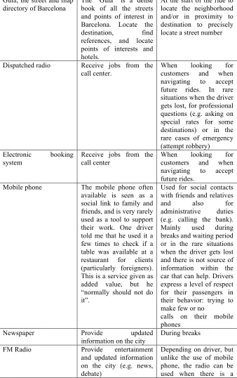
they describe or think is important to discuss. Therefore, we complemented them with additional situational insights from observation of driver work settings (e.g. artifacts used and their evolution, context of use in the wayfinding process) and behavior (e.g. engagement with different types of geoinformation such as streets numbers, instructions, points of interest) while driving. Acting as customers, we requested rides from and to a railway station, a major hotel and an address at one of the many very narrow streets of the Gracia neighborhood in Barcelona. Each informant took part in one session, lasting from 45 minutes to 1 hour, divided in two halves, situational insights and semi-structured interviews respectively.
Figure 1. Waiting area at the Barcelona airport. Usual activities include fixing or cleaning the taxi, sleeping, reading, eating and playing.
We collected rich data consisting of photos of work settings (e.g. to record the eco-system of artifacts), videos of taxi rides (e.g. to capture key moments of access to geoinformation) and written field notes from the interviews. We analyzed and compacted the data after each session. Our analysis consisted in a careful reading of the different materials and in highlighting parts that were related to the phases of the co-evolution we wanted to focus on. We organized the relevant parts into common themes, and coded the documents using the emerging themes. The sessions were conducted in Spanish; we translate some excerpts for this paper. We summarize the findings extracted from these themes in the following section.
4. Findings
support their practice, then how this context evolves during the navigation and its situated activities, and finally, how it impacts their knowledge of the city and in return how the knowledge impacts on the use of the navigation systems. This process led us to reveal a contradiction in the evolution between the serenity drivers expect from the presence of location-aware system and the need to interact with the customers to learn the city.
4.1. The satnav system as an addition to an existing ecosystem of artifacts
We developed an artifact model to start the observation framework, showing the physical things supporting the work, along with their usage, purpose and information content. We used it to define the types of necessary tools, how they relate to each other, then when and why drivers access their geoinformation (Table 1).
The navigation system completes an arrangement of artifacts providing layers of geoinformation to support the job (Figure 2). Based on our observations, we categorize some as detecting real-time information sources such as the satnav system, dispatched radio, electronic booking system, mobile phone and radio. Another category of artifacts provide more aysinchronous information of the city; the newspapers to keep the knowledge of events and activities in the city up the day, scribbled list of “unofficial” points of interests requested by customers such as strip clubs, and above all the street and map directory of Barcelona “Guia Urbana de Barcelona” (Guia) generally kept at reach on the passenger seat, above the dashboard or the interior storage compartment.
Artifacts Purpose Context and situation of
use
Satellite navigation system
Inform on the whereabouts, provide directions to destination (e.g. street number, hotel, place) Keep track of
At the start of the ride to locate the neighborhood and/or in proximity to destination to precisely locate a street number5
5 Satellite navigation systems have two main modes. In the passive mode the
radars. Guia, the street and map
directory of Barcelona
The “Guia” is a dense book of all the streets and points of interest in Barcelona. Locate the destination, find references, and locate points of interests and hotels.
At the start of the ride to locate the neighborhood and/or in proximity to destination to precisely locate a street number
Dispatched radio Receive jobs from the call center.
When looking for customers and when navigating to accept future rides. In rare situations when the driver gets lost, for professional questions (e.g. asking on special rates for some destinations) or in the rare cases of emergency (attempt robbery)
Electronic booking system
Receive jobs from the call center
When looking for customers and when navigating to accept future rides.
Mobile phone The mobile phone often available is seen as a social link to family and friends, and is very rarely used as a tool to support their work. One driver told me that he used it a few times to check if a table was available at a restaurant for clients (particularly foreigners). This is a service given as added value, but he “normally should not do it”.
Used for social contacts with friends and relatives and also for administrative duties (e.g. calling the bank). Mainly used during breaks and waiting period or in the rare situations when the driver gets lost and there is not source of information within the car that can help. Drivers express a level of respect for their passengers in their behavior: trying to make few or no
calls on their mobile phones
Newspaper Provide updated information on the city
During breaks
FM Radio Provide entertainment and updated information on the city (e.g. news, debate)
[image:50.499.81.419.89.627.2]passenger with some respect by keeping the radio volume low. Handwritten notes Store information on
informal destinations of the city that are not present in the Guia and in the navigation system
To keep track of specific destinations and opening hours. On customer request.
Table 1. The eco-system of artifacts that taxi drivers use for navigation, social interactions and to update their knowledge
Figure 2. Distribution of the ecosystem of artifacts for navigation and update the knowledge: Dispatched radio, computer-assisted dispatch, FM radio, satellite navigation system, newspaper, paper notes and the Guia. Mobile phones are kept in the pocket, in the compartments or with a specific hand-free car kit.
4.2. The phases of wayfinding
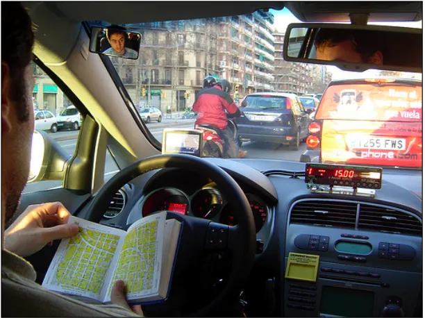
[image:51.499.153.355.214.506.2]There is a “to go” phase in which the driver takes the proper direction and the “to arrive” phase that necessitates different geoinformation at a different granularity drop off location (the number of the street, a monument, a corner). In rides to unknown destinations, drivers seem to access the geoinformation as in a “funnel”. First, there is a tendency to quickly retrieve in the paper-based street directory the area of the destination point. If the paper map does not provide enough information such as reference points to precisely arrive at the area, the drivers engage with the navigation system. No detailed information is needed at that moment of the ride. It is only when approaching the destination area, that the exact address in the navigation system is entered. Informant B explained that he engages with the system at that moment to avoid any misleading information on the direction to the destination (Figure 3). Indeed, a taxi driver applies several paths depending on the time of the day and circumstances (e.g. traffic, weather conditions, preference of passenger).
territory and be either very cautious in the path taken to enter the area (”I am a very good observer” said informant A) or use their satnav with destination Barcelona. That can be landmarks (e.g. a tall building), the topology (e.g. a mountain/hill). But getting a sense of orientation can easily become problematic (e.g. during nighttime or bad weather conditions when tall buildings and mountains are not clearly visible). This is when a satnav system comes in handy. Informant B mentioned that in that in these situations he entered “Plaza Espana”, a large roundabout in the center of Barcelona. Other access their satnav bookmark of saved destinations such as “home” or “Barcelona center”.
4.3. A modified learning process