© 2017 Universidad Nacional Autónoma de México, Centro de Ciencias de la Atmósfera.
This is an open access article under the CC BY-NC-ND License (http://creativecommons.org/licenses/by-nc-nd/4.0/).
Population and trends in the global mean temperature
RICHARD S.J. TOL1,2,3
1 Department of Economics, University of Sussex, BN1 9SL Falmer, United Kingdom
2 Institute for Environmental Studies and Department of Spatial Economics, Vrije Universiteit Amsterdam, The Netherlands
3 Tinbergen Institute, Amsterdam, The Netherlands; CESifo, Munich, Germany
E-mail: r.tol@sussex.ac.uk
Received: January 13, 2017; accepted: March 9, 2017
RESUMEN
El índice ideal de Fisher, que se desarrolló para medir la inflación en los precios, se utiliza para definir una tendencia de temperatura ponderada demográficamente. Este método tiene la ventaja de que la tendencia es representativa de la distribución poblacional a lo largo de toda la muestra pero sin mezclar la tendencia pobla-cional con la tendencia en la temperatura. Demuestro que la tendencia en la media global de temperatura del aire ponderada por área es diferente en detalles clave a la tendencia ponderada demográficamente. Amplío el índice para incluir los efectos de la urbanización y la isla de calor, lo que modifica nuevamente la tendencia de manera sustancial. Y amplío aún más el índice para incluir la migración internacional, pero esto tiene un impacto mínimo sobre la tendencia.
ABSTRACT
The Fisher ideal index, developed to measure price inflation, is applied to define a population-weighted tem-perature trend. This method has the advantages that the trend is representative for the population distribution throughout the sample but without conflating the trend in the population distribution and the trend in the temperature. I show that the trend in the global area-weighted average surface air temperature is different in key details from the population-weighted trend. I extend the index to include urbanization and the urban heat island effect. This substantially changes the trend again. I further extend the index to include international migration, but this has a minor impact on the trend.
Keywords: Population-weighted temperature trend, Fisher index, JEL Classification:Q54.
1. Introduction
The global annual mean surface air temperature is typically defined as an area-weighted average of local temperatures. This definition makes sense from a meteorological perspective, but the distribution of the human population over the surface of the planet is rather uneven. Hardly any humans live at sea, and desert, tundra and rainforest show low population densities. Climate change in such areas is much less relevant to the human condition than warming in cities. In this paper, I therefore discuss temperature
trends as experienced by humans. I do so in three steps, accounting for changes in population density, for urbanization, and for migration.
122 R.S.J. Tol
I am not the first to depart from area-weighted trends in climate variables. For instance, Lobell et al. (2011) and Auffhammer et al. (2013) compute cropping-area and growing-season trends in tempera-ture and precipitation. However, they assume that cropping-area and growing season do not change. This implies that the estimated trend is representative only for part of the sample, and discrepancies grow with the distance to the base year. Dell et al. (2014) nonetheless recommend this method.
Studies of energy demand commonly use pop-ulation-weighted temperatures, or rather popula-tion-weighted heating and cooling degree days. Quayle and Diaz (1980), Taylor (1981), Guttman (1983) and NOAA (http://www.cpc.ncep.noaa.gov/ products/analysis_monitoring/cdus/degree_days/) compute population-weighted degree-days, but with constant population-weights. These studies suffer the same problem as the Lobell et al. paper cited above. On the other hand, Downton et al. (1988), EIA (2012) and Shi et al. (2016) compute population- weighted degree-days, with current population-weights. The resulting trend does not suffer from lack of repre-sentativeness but—as made rigorous below—it does conflate the trend in temperature with the trend in the spatial distribution of the population. Michaels and Knappenberger (2014) fall into the same trap when computing the ’’experiential temperature” trend for the USA.
This paper presents a compromise between un-representative and conflated trends. The methods used are taken from price inflation. Price inflation measures the increase in average prices, say of consumer goods. This is a weighted average, as items more commonly bought should be more important. The common basket of goods changes over time and so the weights should be adjusted. Etienne Laspeyres and Hermann Paasche proposed methods to measure price inflation, later refined by Irving Fisher. These methods have in common that the weights used ensure that the weighted average remains representative, and ensure that no spurious trend is introduced.
Obviously, the measurement of price inflation has moved on since the late 19th century (Diewert, 1998; Nordhaus, 1998; Hausman, 2003; Schultze, 2003;
Broda and Weinstein, 2006; Handbury and Weinstein, 2015). Most of the later refinements are in response to the peculiarities of consumer prices and expenditures, rather than about the general principles of trends in weighted averages. There are two issues particular to population-weighted temperature averages, viz. urbanization and migration. As a third contribution, I propose and apply methods to correct the tempera-ture record for the urban heat island effect, and for international movement of people.
The paper proceeds as follows. Section 2 presents the data and their sources. Section 3 discusses the methods for computing the population-weighted temperature trend in the presence of changes in population patterns (3.1), urbanization (3.2), and international migration (3.3). Section 4 shows the results. Section 5 concludes.
2. Data
Population data are taken from Klein-Goldewijk et al. (2010). Data are population counts on a 0.5’ × 0.5’ grid. The Matlab code to convert the data to a 0.5º × 0.5º grid is given in the appendix. I use the data from 1900 to 2000, in 10-yr time steps. Unfortunately, the gridded population for 2010 has yet to be released. The data serve to illustrate the methods outlined below.
Temperature data are from CRU TS v3.24 (Harris et al., 2014). Data are monthly temperature average on a 0.5º × 0.5º grid. I use the data from 1900 to 2010, and compute the 21-yr average centered on 1910, 1920,..., 2000. The code is given in the Appendix.
Data on urbanization are from the World Urban-ization Prospects project of the UN Population Di-vision.1 Specifically, the data are population counts, per pentade, from 1950 to 2015, for the 1692 urban agglomerations that had 300 000 inhabitants or more in 2014. Reba et al. (2016) have data that go back further in time, but coverage is not comprehensive.
The urban heat island effect is not consistently observed over space and time. Instead, I impute the warming due to urbanization by
Uc,t= αPc,tβ (1)
where Uc,t is the warming due to the urban heat
island effect in city c at time t; Pc,t is the number
of inhabitants of city c at time t; and α and β are parameters.
Following Karl et al. (1988), I set α = 0.00174 and β = 0.45. These values are appropriate for annual temperatures for cities of over 100 000 people.
Data on international migration is taken from the UN Population Division (see International mi-grant stock by destination and origin on http://www. un.org/en/development/desa/population/migration/ data/estimates2/estimates15.shtml),which draws on Parsons et al. (2007). This database has estimates of the total stock of migrants by origin and destination, per pentade, from 1990 to 2015. I am not aware of a global database that goes back further in time.
3. Methods
3.1 Population density
As a first step, I compute the increase in the global annual mean surface air temperature weighted by the population per grid cell. Starting from the gridded tem-perature data, the global mean temtem-perature is dened as
TA
t : =
∑
G1∑
g=1 AgG g=1
Tg,tAg (2)
where
TtA is the area-weighted global annual mean surface
air temperature in year t;
Tg,t is the annual mean surface air temperate in grid
cell g in year t;
Ag is the surface area of grid cell g; and
G is the number of grid cells.
Because the grid cell area is constant over time, the change in the global mean temperature is dened as
∆TA
t : =TtA+1−TtA (3)
The population-weighted temperature could be defined as in (2), with population weights P replacing area-weights A. However, as population is not con-stant over time and population growth not uniform over space, the equivalent of (3) would conflate population and temperature change. Define
TP
t : =
∑
G 1 g=1 Pg,tG
∑
g=1Tg,tPg,t (4)
where Pg,t is the human population in grid cell g in
year t. Let Pt be the total population at time t. Then
∆TP
t : = TtP+1 − TtP
= P1
t+1 G
∑
∑
g=1
Tg,t+1 Pg,t+1 − P1
t G g=1
Tg,tPg,t
≈
G g=1
∆Tg,t PPg,t
t + Tg,t∆
Pg,t
Pt
∑
(5)
That is, (4) does not measure the temperature trend, but rather the temperature trend and the trend in the regional composition of the population.
The temperature change as experienced by the av-erage person can be defined using the additive version of the chained Laspeyres Index (Laspeyres, 1871)
∆TtP,L: = 1
∑
G∑
∑
g=1Pg,t(
G g=1
Tg,t+1Pg,t−
G g=1
Tg,tPg,t
)
(6)where
TtP,L is the Laspeyres population-weighted global
annual mean surface air temperature in year t; and other variables are as above.
In (6) population-weights for the start year are used. These weights are appropriate for that year, but less so for the end year.
Note that the Laspeyres index in (6) defines the change in the average temperature. The tempera-ture level is found by starting from an arbitrary base (set at naught below) and adding subsequent changes.
Instead of the Laspeyres index, we can use the chained Paasche Index (Paasche, 1877)
∆TtP,P: = 1
∑
∑
∑
G
g=1Pg,t+1 G g=1
Tg,t+1Pg,t+1
−
G g=1
Tg,tPg,t+1
(
)
(7) or the Fisher Ideal Index (Fisher, 1892)∆TtP,F : = 0.5
(
TtP,L+TtP,P)
(8)124 R.S.J. Tol
the arithmetic average of the two. Laspeyres is representative for the past, Paasche for the present, and Fisher is a compromise between the two.
Equations (6) and (7) show the chained indices, in which the weights are updated every time step, but we can of course also use the population weights in the first (Laspeyres) and final period (Paasche).
The code to compute the various trends is given in the appendix.
3.2 Urbanization
Temperature records are homogenized, that is, tem-perature trends induced by changes in the equipment or the immediate environment of the weather station are removed—including the impact of urbanization. This makes perfect sense if the aim is to measure changes in the global environment, but not at all if the aim is to measure the warming experienced by humans. As a second step, therefore, I will reintro-duce the urban heat island effect.
Let us redefine the population weighted global mean surface air temperature as
TP*
t : = 1
∑
∑
∑
G g=1 Pg,t
G g=1
(Tg,t+Ug,t)Pg,tνg,t + G
g=1
Tg,tPg,t (1 − νg,t)
(9)
where
Ug,t is the warming due to the urban heat island effect
in grid cell g at time t;
vg,t is the fraction of people living in urban centres
in grid cell g at time t; and
other variables are defined as above. The Laspeyres index is then defined as
∆TP*,L t := 1
∑
∑
∑
∑
∑
∑
∑
∑
∑
∑
G g=1Pg,tG g=1
(Tg,t+1+Ug,t+1)Pg,tνg,t
+
G g=1
Tg,t+1 Pg,t (1 − νg,t)
−
G g=1
(Tg,t + Ug,t)Pg,tνg,t
−
G g=1
Tg,tPg,t (1 − νg,t)
= ∆TtP,L+ 1
(
)
G g=1 Pg,t
G g=1
Ug,t+1Pg,tνg,t
− G
g=1
Ug,tPg,tνg,t
= : ∆TP,L
t +
G
g=1 Pg,tνg,t G
g=1 Pg,t
∆UP,L t
∆TtP*,L
:= 1
∑
∑
∑
∑
∑
∑
∑
∑
∑
∑
G g=1Pg,tG g=1
(Tg,t+1+Ug,t+1)Pg,tνg,t
+ G
g=1
Tg,t+1Pg,t (1 − νg,t)
− G
g=1
(Tg,t + Ug,t)Pg,tνg,t
− G
g=1
Tg,tPg,t (1 − νg,t)
= ∆TtP,L+ 1
(
)
G g=1 Pg,t
G g=1
Ug,t+1Pg,tνg,t
−
G g=1
Ug,tPg,tνg,t
= : ∆TtP,L + G
g=1 Pg,tνg,t G
g=1 Pg,t
∆UtP,L
In other words, the Laspeyres index of global warming plus urban heat island is the Laspeyres index of global warming plus the Laspeyres index of urban heat island times the rate of urbanization. The same result carries over to the Paasche and Fisher indices.
3.3 Internal migration
People experience climate change not only in the place where they live, but also when they move. This may matter for population-weighted global warming because, although only relatively few people are affected, they experience relatively large climate change. This can be included as
∆
T
Mt
=
∑
1
∑ ∑
∑
O
o=1 Dd=1
M
o,d,t,t+1 Oo=1 D
d=1
(
T
d,t+1−
T
o,t)
M
o,d,t,t+1(11)
where Mo,d,t,t+1 denotes the number of people who migrated from o to d between time t and t + 1. This expression should be added to the population-weight-ed temperature after multiplication by the share of people migrating.
4. Results
4.1 Population density
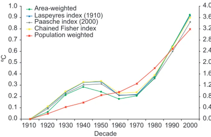
faster than the area-weighted record until 1950, and slower afterwards. The difference between the ar-ea-weighted temperature and the chained Fisher index is 0.1º C in 1950; and this gap closes again by 2000. These differences matter, say, if you would regress economic growth on climate change, because the slope of the Fisher index is 40% steeper in the first half of the century, and 18% shallower in the second half.
The differences between the population-weighted temperature records are less pronounced. If we follow Laspeyres and use the 1910 population as weights, overall warming is 0.06º C higher than if we follow Paasche and use the 2000 population. The Fisher index lies in between. The pattern of warming until 1940, cooling until 1970, and warming after 1970 is the same in all three records, but the slopes differ. For instance, mid-century cooling and late-century warm-ing are most pronounced in the Laspeyres index.
For comparison, Figure 1 also shows the popula-tion-weighted temperature trend if current population weights are used, as in (4) and (5). The difference is large. Warming is now 3.2º C over the century. As argued above, this approach conflates the trend in the temperature with the trend in the distribution of the population, and the latter clearly dominates.
4.2 Urbanization
Figure 2 shows the impact of urbanization and the urban heat island effect on the population-weighted average temperature. In 1950, the average urban heat island effect is 0.98 ºC, that is, the urban environment
was on average one degree warmer than it would have been had it been countryside. This rises to 1.64º C in the year 2000. In 1950, 16% of the world population lived in the cities for which we have data, rising to 26% in 2000. Urbanization thus adds 0.16 × 0.98º C = 16º C to the temperature in 1950 and 0.26 × 1.64º C = 0.42º C in 2000. As the Fisher index rose by 0.54º C between 1950 and 2000, the extra warming of 0.26º C due to urbanization is relatively large.
4.3 Internal migration
The first estimate of the stock of international mi-grants by country of origin and destination is for the year 1990. In that year, 154 million migrants lived in countries 1.60º C colder, on average, than their coun-try of origin. By the year 2000, there were 175 mil-lion migrants living in countries on average 2.85º C colder than where they came from. That is, in the last decade of the 20th century, 20 million migrants experienced a cooling of 12.3º C. This is large relative to the observed warming, but additional migrants are only some 0.4% of the world population, so the overall experience of warming does not change much: We need to subtract 0.04º C from the temperatures shown in Figure 2.
Figure 3 shows the range of temperature change as experienced by those who moved country in 2000 or before. These changes are large. A quarter of migrants experienced warming or cooling of 2º C or less, but 42% experienced an absolute temperature change of 10º C or more. 60% of migrants moved from warmer Fig. 1. The global mean surface air temperature over land
in degrees Celsius, weighted by area and by population size, using the Laspeyres Index, the Paasche index, and the chained Fisher index (left axis) and weighted by current population (right axis).
1.0 0.9 0.8 0.7 0.6 0.5 0.4 0.3 0.2 0.1 0.0
1910 1920 1930 1940 1950 1960 1970 1980 1990 2000 4.0 Area-weighted
Laspeyres index (1910) Paasche index (2000) Chained Fisher index Population weighted 3.6 3.2 2.8 2.4 2.0 1.6 1.2 0.8 0.4 0.0 Decade ºC 1.4 1.2 1.0 0.8 0.6 0.4 0.2 0.0
1910 1920 1930 1940 1950 1960 1970 1980 1990 2000 Area-weighted
Chained Fisher index
Chained Fisher index including urbanization Difference due to urbanization
Decade
ºC
126 R.S.J. Tol
to colder countries. The 40% who experienced warming, and particularly the 28% who experienced warming of more than 2º C could be used as case studies of the impacts of future climate change.
5. Discussion and conclusion
Previous studies applying population-weighted average temperatures used either constant weights, so that the average is not representative for part of the sample, or current weights, so that the trend conflates trends in the temperature with trends in the distribution of the population. I propose to use the methods used to estimate price inflation, particularly the Fisher ideal index, to derive population-weight-ed trends in temperature as this maintains repre-sentativeness without conflation. I extend these methods to include urbanization and the urban heat island effect, and to reflect international migration. An application to the temperature trends in the 20th century shows (1) that the population- weighted temperature trend differs in key details from the area-weighted temperature trend; (2) that conflation is a bigger problem than non-representativeness; (3) that the urban heat island effect substantially adds to warming; and (4) that international migration lead to a minor drop in the temperature experienced by the average person.
The methods proposed here can be used for any climate variable and for any weight. Temperature and population are just one of many possible applications. Rainfall and cropping area would be an obvious next application. I use a simple equation to reintroduce the urban heat island effect into the temperature record in
a partial heterogenization. In future work, the urban heat island effect should not be removed from the temperature records – that is, homogenization should be partial.
Empirical papers that relate changes in climate to changes in economic activity (Dell et al., 2012; Lemoine and Kapnick, 2015), crop yields (Lobell and Asner, 2003; Chen et al., 2004; Lin and Huybers, 2012), species abundance (Root et al., 2003; Parmesan and Yohe, 2003; Atkins and Travis, 2010; Eglington and Pearce-Higgins, 2012) or some other variable of inter-est should take care in constructing the climate variable of interest. As shown above, the slope differs between area- and population-weighted temperature trends. This could well lead to spurious inference. Recall that the area- and population-weighted temperatures diverge in the first half of the 20th century and converge in the second. An impact indicator that co-trends with either can therefore not co-trend with the other.
There is thus a rich vein of future research follow-ing on from the methods proposed here. The paper also identifies the experience of migration as a laboratory for the impact of climate change.
Acknowledgments
John Kennedy had excellent comments on an earlier version.
References
Atkins K.E. and Travis J.M.J., 2010. Local adaptation and the evolution of species’ ranges under climate change. J. Theor. Biol. 266, 449-457, 2010.
doi: 10.1016/j.jtbi.2010.07.014
Auffhammer M., Hsiang S.M., Schlenker W. and Sobel A., 2013. Using weather data and climate model output in economic analyses of climate change. Rev. Env. Econ. Policy 7, 181-198.
doi: 10.1093/reep/ret016
Broda C. and Weinstein D.E., 2006. Globalization and the gains from variety. Q. J. Econ. 121, 541-585.
doi: 10.1162/qjec.2006.121.2.541
Chen C.C., McCarl B.A. and Schimmelpfennig D.E., 2004. Yield variability as influenced by climate: A statistical investigation. Climatic Change, 66, 239-261.
doi: 10.1023/B:CLIM.0000043159.33816.e5
Dell M., Jones B.F. and Olken B.A., 2012. Temperature shocks and economic growth: Evidence from the last half century. Am. Econ. J.-Macroecon. 4, 66-95. doi: 10.1257/mac.4.3.66
Fig. 3: Histogram of the warming or cooling experienced by the migrant population in the year 2000.
0.07
0.06
0.05
0.04
0.03
0.02
0.01
0
–35 –30 –25 –20 –15 –10 –5 0 5 10 15 20 25 30 35 Temperature difference between
origin and destination country (ºC)
Dell M., Jones B.F. and Olken B.A., 2014. What do we learn from the weather? The new climate-economy literature. J. Econ. Lit. 52, 740-98.
doi: 10.1257/jel.52.3.740
Diewert W.E., 1998. Index number issues in the consumer price index. J. Econ. Perspect. 12, 47-58.
Downton M.W., Stewart T.R. and Miller K.A., 1988. Esti-mating historical heating and cooling needs. Per capita degree days. J. Appl. Meteorol. 27, 84-90.
doi: 10.1175/1520-0450(1988)027(0084:EH-HACN)2.0.C0;2
Eglington S.M. and Pearce-Higgins J.W., 2012. Disen-tangling the relative importance of changes in climate and land-use intensity in driving recent bird population trends. PLoS ONE 7.
doi: 10.1371/journal.pone.0030407
EIA, 2012. Short-term energy outlook supplement: Change in regional and u.s. degree- day calculations. Technical report, US Energy Information Agency, Washington, DC. Available at: https://www.eia.gov/outlooks/steo/ special/pdf/2012_sp_04.pdf
Fisher I., 1892. Mathematical investigations in the theory of value and prices. Augustus M. Kelley, New York.
Guttman N.B., 1983. Variability of population-weighted seasonal heating degree days. J. Clim. Appl. Meteorol. 22, 495-501
doi: 10.1175/1520-0450(1983)022(0495:V0PW-SH)2.0.C0;2
Handbury J. and Weinstein D.E., 2015. Goods prices and availability in cities. Rev. Econ. Stud. 82, 258-296. doi: 10.1093/restud/rdu033
Hausman J., 2003. Sources of bias and solutions to bias in the consumer price index. J. Econ. Perspect. 17, 23-44. doi: 10.1257/089533003321164930
Harris I., Jones P.D., Osborn T.J. and Lister D.H., 2014. Up-dated high-resolution grids of monthly climatic observa-tions the cru ts3.10 dataset. Int. J. Climatol. 34, 623-642. doi: 10.1002/ joc.3711
Karl T. R., Diaz H. F. and Kukla G., 1988. Urbanization: Its detection and effect in the United States climate record. J. Climate 1, 1099-1123.
doi: 10.1175/1520-0442(1988)001(1099:UI-DAEI)2.0.C0;2
Klein-Goldewijk K., Beusen A. and Janssen P., 2010. Long-term dynamic modeling of global population and built-up area in a spatially explicit way: Hyde 3.1. Holocene 20, 565-573.
Laspeyres E., 1871. Die berechnung einer mittleren
waren-preissteigerung. Jahrbuecher fuer Nationaloekonomie und Statistik 16, 296-314.
Lemoine D. and Kapnick S., 2015. A top-down approach to projecting market impacts of climate change. Nat. Clim. Change 6, 51-55.
doi: 10.1038/nclimate2759
Lin M. and Huybers P., 2012. Reckoning wheat yield trends. Environ. Res. Lett. 7.
doi: 10.1088/1748-9326/7/2/024016
Lobell D.B. and Asner G.P., 2003. Climate and manage-ment contributions to recent trends in U.S. agricultural yields. Science 299, 1032.
Lobell D.B., Schlenker W. and Costa-Roberts J., 2011. Climate trends and global crop production since 1980. Science 333, 616-620. doi: 10.1126/science.1204531 Michaels P.J. and Knappenberger P.C., 2014. Some like it hot. Cato Institute. Available at: https: //www.cato. org/blog/some-it-hot.
Paasche H., 1877. Ueber die Entwicklung der Preise und der Rente des Immo- biUarbesitzes zu Halle. A. S. Ploetz, Halle an der Saale.
Nordhaus W. D., 1998. Quality change in price indexes. J. Econ. Perspect. 12, 59-68.
Parmesan C. and Yohe G. W., 2003. A globally coherent fingerprint of climate change impacts across natural systems. Nature 421, 37-41. doi:10.1038/nature01286 Parsons C.R., Skeldon R., Walmsley T.L. and Winters
L.A., 2007. Quantifying international migration: A database of bilateral migrant stocks. Working paper. Available at: https://openknowledge.worldbank.org/ handle/10986/7244.
Quayle R.G. and Diaz H.F., 1980. Heating degree day data applied to residential heating energy consumption. J. Appl. Meteorol. 19, 241-246.
doi: 10.1175/1520-0450(1980)019(0241:HDDDAT) 2.0.C0;2
Reba M., Reitsma F. and Seto K.C., 2016. Spatializing 6,000 years of global urbanization from 3700 BC to AD 2000. Scientific Data 3, 160034.
doi: 10.1038/sdata.2016.34
Root T.L., Price J.T., Hall K.R., Schneider S.H., Rosenz-weig C. and Pounds J.A., 2003. Fingerprints of global warming on wild animals and plants. Nature 421, 57-60.
doi:10.1038/nature01333
Schultze C.L., 2003. The consumer price index: Concep-tual issues and practical suggestions. J. Econ. Perspect. 17, 3-22.
128 R.S.J. Tol
Shi Y., Gao X., Xu Y., Giorgi F. and Chen D., 2016. Effects of climate change on heating and cooling degree days and potential energy demand in the household sector of china. Clim. Res. 67, 135-149.
doi: 10.3354/cr01360
Appendix: Matlab codes
1. processarea.m
load gridarea.txt
%area for 5’x5’ grid
gridarea(gridarea==-9999)=0;
area = zeros(NLat, NLong);
%aggregate 5’x5’ grid to 30’x30’ grid for i = 1:NLat
for j = 1:NLong for k=1:6 for l=1:6
area(i,j) = area(i,j) + gridarea(k+(i-1)*6,l+(j-1)*6); end
end end end
2. processHYDE.m
clear all
processarea
130 R.S.J. Tol
popc1900AD(popc1900AD= = –9999)=0; popc1910AD(popc1910AD= = –9999)=0; popc1920AD(popc1920AD= = –9999)=0; popc1930AD(popc1930AD= = –9999)=0; popc1940AD(popc1940AD= = –9999)=0; popc1950AD(popc1950AD= = –9999)=0; popc1960AD(popc1960AD= = –9999)=0; popc1970AD(popc1970AD= = –9999)=0; popc1980AD(popc1980AD= = –9999)=0; popc1990AD(popc1990AD= = –9999)=0; popc2000AD(popc2000AD= = –9999)=0;
NLong = 720; NLat = 360;
P1900 = zeros(NLat, NLong); P1910 = zeros(NLat, NLong); P1920 = zeros(NLat, NLong); P1930 = zeros(NLat, NLong); P1940 = zeros(NLat, NLong); P1950 = zeros(NLat, NLong); P1960 = zeros(NLat, NLong); P1970 = zeros(NLat, NLong); P1980 = zeros(NLat, NLong); P1990 = zeros(NLat, NLong); P2000 = zeros(NLat, NLong);
%aggregate 5’x5’ grid to 30’x30’ grid for i = 1:NLat
for j = 1:NLong for k=1:6 for l=1:6
P1900(i,j) = P1900(i,j) + popc1900AD(k+(i-1)*6,l+(j-1)*6); P1910(i,j) = P1910(i,j) + popc1910AD(k+(i-1)*6,l+(j-1)*6); P1920(i,j) = P1920(i,j) + popc1920AD(k+(i-1)*6,l+(j-1)*6); P1930(i,j) = P1930(i,j) + popc1930AD(k+(i-1)*6,l+(j-1)*6); P1940(i,j) = P1940(i,j) + popc1940AD(k+(i-1)*6,l+(j-1)*6); P1950(i,j) = P1950(i,j) + popc1950AD(k+(i-1)*6,l+(j-1)*6); P1960(i,j) = P1960(i,j) + popc1960AD(k+(i-1)*6,l+(j-1)*6); P1970(i,j) = P1970(i,j) + popc1970AD(k+(i-1)*6,l+(j-1)*6); P1980(i,j) = P1980(i,j) + popc1980AD(k+(i-1)*6,l+(j-1)*6); P1990(i,j) = P1990(i,j) + popc1990AD(k+(i-1)*6,l+(j-1)*6); P2000(i,j) = P2000(i,j) + popc2000AD(k+(i-1)*6,l+(j-1)*6);
end
end end end
3. processCRU.m
clear all
NLong = 720; NLat = 360; NMonth = 12; NYear =113;
NLines = NLat*NMonth*NYear;
load cru_ ts3.22.1901.2013.tmp.dat A=cru_ ts3_ 22_ 1901_ 2013_ tmp; clear cru*
A(A==-999)=NaN;
B = zeros(NLat*NYear, NLong);
%compute annual average temperature for y = 1:NYear
for m = 1:NMonth for l = 1:NLat
Aind = l+(m-1)*NLat+(y-1)*NLat*NMonth; Bind = l+(y-1)*NLat;
B(Bind,:) =B(Bind,:) + A(Aind,:)/12; end
end end
T1910 = zeros(NLat,NLong); T1920 = zeros(NLat,NLong); T1930 = zeros(NLat,NLong); T1940 = zeros(NLat,NLong); T1950 = zeros(NLat,NLong); T1960 = zeros(NLat,NLong); T1970 = zeros(NLat,NLong); T1980 = zeros(NLat,NLong); T1990 = zeros(NLat,NLong); T2000 = zeros(NLat,NLong);
NAve = 21;
%compute 21-year average temperature and store it in a grid for y = 1:NAve
for l = 1:NLat
132 R.S.J. Tol
T1970(l,:) = T1970(l,:) + B(l + (y+60-1)*NLat,:)/NAve; T1980(l,:) = T1980(l,:) + B(l + (y+70-1)*NLat,:)/NAve; T1990(l,:) = T1990(l,:) + B(l + (y+80-1)*NLat,:)/NAve; T2000(l,:) = T2000(l,:) + B(l + (y+90-1)*NLat,:)/NAve; end
end
save temperature
4. processall.m
clear all
load temperature load population
totarea = sum(sum(area));
%divide by ten to convert from milligrade to centigrade, add 273 to convert from Celsius to Kelvin T1910 = T1910/10 + 273.15; T1920 = T1920/10 + 273.15;
T1930 = T1930/10 + 273.15; T1940 = T1940/10 + 273.15; T1950 = T1950/10 + 273.15; T1960 = T1960/10 + 273.15; T1970 = T1970/10 + 273.15; T1980 = T1980/10 + 273.15; T1990 = T1990/10 + 273.15; T2000 = T2000/10 + 273.15;
gTemp = (T2000-T1910)./T1910; gTemp(isnan(gTemp)) = 0;
area = flipud(area);
%area-weighted temperature GMT(1) = sum(sum(T1910.*area))/totarea; GMT(2) = sum(sum(T1920.*area))/totarea;
GMT(3) = sum(sum(T1930.*area))/totarea; GMT(4) = sum(sum(T1940.*area))/totarea; GMT(5) = sum(sum(T1950.*area))/totarea; GMT(6) = sum(sum(T1960.*area))/totarea; GMT(7) = sum(sum(T1970.*area))/totarea; GMT(8) = sum(sum(T1980.*area))/totarea; GMT(9) = sum(sum(T1990.*area))/totarea; GMT(10) = sum(sum(T2000.*area))/totarea;
P1910 = flipud(P1910); P1920 = flipud(P1920); P1930 = flipud(P1930); P1940 = flipud(P1940); P1950 = flipud(P1950); P1960 = flipud(P1960); P1970 = flipud(P1970); P1980 = flipud(P1980); P1990 = flipud(P1990); P2000 = flipud(P2000);
gPop = (P2000-P1910)./P1910; gPop(isnan(gPop)) = 0;
º/oLaspeyres
GMTL(1) = sum(sum(T1910.*P1910))/sum(sum(P1910)); GMTL(2) = sum(sum(T1920.*P1910))/sum(sum(P1910)); GMTL(3) = sum(sum(T1930.*P1910))/sum(sum(P1910)); GMTL(4) = sum(sum(T1940.*P1910))/sum(sum(P1910)); GMTL(5) = sum(sum(T1950.*P1910))/sum(sum(P1910)); GMTL(6) = sum(sum(T1960.*P1910))/sum(sum(P1910)); GMTL(7) = sum(sum(T1970.*P1910))/sum(sum(P1910)); GMTL(8) = sum(sum(T1980.*P1910))/sum(sum(P1910)); GMTL(9) = sum(sum(T1990.*P1910))/sum(sum(P1910)); GMTL(10) = sum(sum(T2000.*P1910))/sum(sum(P1910));
%Paasche
134 R.S.J. Tol
%population
GMTp(1) = sum(sum(T1910.*P1910))/sum(sum(P1910)); GMTp(2) = sum(sum(T1920.*P1920))/sum(sum(P1920)); GMTp(3) = sum(sum(T1930.*P1930))/sum(sum(P1930)); GMTp(4) = sum(sum(T1940.*P1940))/sum(sum(P1940)); GMTp(5) = sum(sum(T1950.*P1950))/sum(sum(P1950)); GMTp(6) = sum(sum(T1960.*P1960))/sum(sum(P1960)); GMTp(7) = sum(sum(T1970.*P1970))/sum(sum(P1970)); GMTp(8) = sum(sum(T1980.*P1980))/sum(sum(P1980)); GMTp(9) = sum(sum(T1990.*P1990))/sum(sum(P1990)); GMTp(10) = sum(sum(T2000.*P2000))/sum(sum(P2000));
%chained Laspeyres CL(1) = 0;
CL(2) = sum(sum(T1920.*P1910))/sum(sum(P1910)) - sum(sum(T1910.*P1910))/sum(sum(P1910)); CL(3) = sum(sum(T1930.*P1920))/sum(sum(P1920)) - sum(sum(T1920.*P1920))/sum(sum(P1920)); CL(4) = sum(sum(T1940.*P1930))/sum(sum(P1930)) - sum(sum(T1930.*P1930))/sum(sum(P1930)); CL(5) = sum(sum(T1950.*P1940))/sum(sum(P1940)) - sum(sum(T1940.*P1940))/sum(sum(P1940)); CL(6) = sum(sum(T1960.*P1950))/sum(sum(P1950)) - sum(sum(T1950.*P1950))/sum(sum(P1950)); CL(7) = sum(sum(T1970.*P1960))/sum(sum(P1960)) - sum(sum(T1960.*P1960))/sum(sum(P1960)); CL(8) = sum(sum(T1980.*P1970))/sum(sum(P1970)) - sum(sum(T1970.*P1970))/sum(sum(P1970)); CL(9) = sum(sum(T1990.*P1980))/sum(sum(P1980)) - sum(sum(T1980.*P1980))/sum(sum(P1980)); CL(10) = sum(sum(T2000.*P1990))/sum(sum(P1990)) - sum(sum(T1990.*P1990))/sum(sum(P1990));
%chained Paasche CP(1) = 0;
CP(2) = sum(sum(T1920.*P1920))/sum(sum(P1920)) - sum(sum(T1910.*P1920))/sum(sum(P1920)); CP(3) = sum(sum(T1930.*P1930))/sum(sum(P1930)) - sum(sum(T1920.*P1930))/sum(sum(P1930)); CP(4) = sum(sum(T1940.*P1940))/sum(sum(P1940)) - sum(sum(T1930.*P1940))/sum(sum(P1940)); CP(5) = sum(sum(T1950.*P1950))/sum(sum(P1950)) - sum(sum(T1940.*P1950))/sum(sum(P1950)); CP(6) = sum(sum(T1960.*P1960))/sum(sum(P1960)) - sum(sum(T1950.*P1960))/sum(sum(P1960)); CP(7) = sum(sum(T1970.*P1970))/sum(sum(P1970)) - sum(sum(T1960.*P1970))/sum(sum(P1970)); CP(8) = sum(sum(T1980.*P1980))/sum(sum(P1980)) - sum(sum(T1970.*P1980))/sum(sum(P1980)); CP(9) = sum(sum(T1990.*P1990))/sum(sum(P1990)) - sum(sum(T1980.*P1990))/sum(sum(P1990)); CP(10) = sum(sum(T2000.*P2000))/sum(sum(P2000)) - sum(sum(T1990.*P2000))/sum(sum(P2000));
%chained Fisher CF = 0.5*(CL + CP);
GMTCL(1) = GMTL(1); GMTCP(1) = GMTL(1); GMTCF(1) = GMTL(1);
GMTCL(i) = GMTCL(i-1) + CL(i); GMTCP(i) = GMTCP(i-1) + CP(i); GMTCF(i) = GMTCF(i-1) + CF(i); end
GMT = GMT - GMT(1); GMTL = GMTL - GMTL(1); GMTP = GMTP - GMTP(1); GMTp = GMTp - GMTp(1); GMTCL = GMTCL - GMTCL(1); GMTCP = GMTCP - GMTCP(1); GMTCF = GMTCF - GMTCF(1);
dec = [1910 1920 1930 1940 1950 1960 1970 1980 1990 2000];