Recent landscape evolution at the "Barranco del Río Dulce Natural Park" (Spain) Landscape units and mapping
18
0
0
Texto completo
(2) 108. LANDSCAPE EVOLUTION AT THE RÍO DULCE NATURAL PARK. amplias superficies de arrasamiento en la Cordillera, aunque quedaron relieves menores aislados. El descenso del nivel de base que ocurre desde el Plioceno, provocado por la transición de endorreica a exorreica en la Cuenca del Tajo, da lugar al comienzo de la incisión fluvial y el descenso del nivel freático, con el desarrollo de los primeros valles fluviales y la captura de depresiones kársticas. Dos fases posteriores, en el Pleistoceno, de incisión fluvial renovada, producen el abandono de algunos valles pliocenos así como capturas fluviales, y el desarrollo y reincision de algunos afluentes. Palabras clave: unidades y cartografía del paisaje, evolución del paisaje, Neógeno, Cuaternario, Parque Natural del Barranco del Río Dulce.. García-Hidalgo, J.F., García Quintana, A., Giménez, R. y Aguilar Larrucea, M. (2016): Recent landscape evolution at the "Barranco del Río Dulce Natural Park" (Spain). Landscape units and mapping. Revista de la Sociedad Geológica de España, 29(1): 107-124.. Landscape information and mapping have many potential applications in environmental sciences and applied geomorphology. Landscape classification and evaluation are necessary, for example, for suitability studies, regional planning or land system inventories, which might be made on the basis of landscape mapping. In this case, planners are usually involved in projects related to sustainable development and social acceptance of land use changes, which is a main issue in various fields within Natural Protected Areas (NPAs). Besides, landscape is a feature usually considered part of our Geological Heritage; and related with this point, it is worthy to mention that there is a strong increase in tourism linked to the aesthetic values and historical quality of nature in general, and the elements of geodiversity in particular. Thus, tourism related to rural landscapes is increasingly offered and demanded in NPAs and Geoparks. These NPAs and Geoparks use the geological heritage in order to, among others, illustrate the processes of landscape evolution, and for training and education (Eder and Patzak 2004). Landscapes and their evolution are originated through different geomorphic processes overlapped along extensive periods of time. The classification and identification of elementary landscape units are then important to understand these processes in the past and their responses (the present landscapes). Landscape mapping, thus, might provide useful information on: 1) the interaction among landscapes and soil, vegetation or climate; 2) the understanding of the recent landscape evolution; and, as a result 3) the future feedback of landscapes to natural and anthropogenic changes, since landscapes units are sensitive to changes due to natural- or human-induced variations in land uses (Giles and Franklin 1998). The shared conditions in these approaches are the visual quality and the spatial structure of the land surface. The visual quality emphasizes features that have to do with its visual assessment or perception by people; thus, the European Landscape Convention (2000) defines the landscape as "an area, as perceived by people". The perceived landscape, however, results on the superposition of relief and landforms, textures and colours; reflecting usually natural features (or, in the case of developed countries, moderately modified natural features, such as agricultural areas) of the territory. Relief, landforms, Revista de la Sociedad Geológica de España, 29(1), 2016. colours and textures depend mainly on geological and geomorphological features of the territory and the vegetation cover. Surprisingly, there have been very few attempts to systematize landscape from earth sciences, in spite of the strong dependence between visual landscape and geological and geomorphological features (Cendrero et al., 1986). This paper presents the first detailed, integrated model for landscape study and mapping in an NPA in the centre of Spain, the “Barranco del Río Dulce” Natural Park (BRDNP). The catchment area of the Dulce River, which forms mainly the BRDNP, shows a sensitive reaction to shifts in climate and vegetation; central Spain also has a long record of human impact on landscapes, though not as intense as in Central Europe. Our primary objective was to obtain results that were useful both for the management of the BRDNP by non-scientific technicians and politicians (classification, valuation, conservation, reclamation, etc.); and also for scientific and non-scientific use by the general public (visits, educational activities, etc.). We also discuss the different types of boundaries for landscape units. Finally, as landscapes are the result of past geomorphic and geologic processes, which also control the present-day geomorphic processes (Dehn et al., 2001), the recognised landscape units have then been integrated with other geological data in order to demonstrate the landscape development during late Neogene-Quaternary times, with the aim of further knowing these geomorphic and geological conditions for landscape origin and to establish the recent history of the landscape based on the relative age of its landforms. Materials and methods. A classical approach is followed in this paper. An integrated model for landscape mapping and classification was achieved first by visual identification of landscape units, and second with their compilation and classification in relation to the geological substratum. Landscape and geomorphic data were gathered by aerial photo interpretation and field survey techniques. The entire area was mapped from aerial photographs at a 1:30,000 scale; then landscape units were plotted on 1:25,000 topographic and geological maps..
(3) 109. José. F. García-Hidalgo, Álvaro García Quintana, Rocío Giménez, Miguel Aguilar Larrucea. The entire studied area has been mapped into smaller units that successively incorporated the criteria for grouping in broader units (Godfrey 1977; Guzzetti and Reichenbach 1994). Three kinds of landscape units based on the visual features of the relief have been distinguished: Landscapes, landscape types and landscape systems (Table 1). Landscapes are individual geomorphic landforms composed of several elementary forms (not described in this paper). They are characterized by a visual internal homogeneity, and contrast with other landscapes in their geometry, reflecting their genesis. Landscapes are represented by fifteen visual sceneries (Table 1), and their names are intended to be descriptive. This classification is the basis for landscape mapping and was erected simultaneously with it. The Landscape Systems. Landscape types I.a Main reliefs. I.b Flat terrains I. High plains I.cDissected flat terrains. II.a, Tributaries. Landscapes. I.a.1 Residual reliefs. Ph. 4. Pm. I.b.3 Plateaus. 2. Pc. I.c.4 Dissected upland plains. 7. Rr. I.c.5 Upland plains remnants. 6. Rd. II.a.6 Large gullies. 21. Fg. II.a.8 Rolling areas. 24. Fr. 2. Fc. II.a.7 Small ravines. II.b.10 Asymmetric valleys II.b.11 Symmetric valleys. II.b Main fluvial valleys. 5. Ml. I.b.2 Upland plains. II.a.9 Hanged valleys II. Valleys and gorges. Mp. II.b.12 Terraced valleys. 1. Fv. 3. Va. 7. Vs. 1. Vt. II.b.13 Flat valleys. 2. Vf. II.b.14 Open valleys. 4. Vo. II.b.15 Major valleys. 1. Vm. classification implies and involves a visual and compositional sectorization of the territory and it is a tool for the assessment, management and interpretation of the territory of the BRDNP. Thus, the process of landscape mapping presented here arises from the theoretical concept of landscape units as closed homogeneous areas. The internal properties of these units have a crucial role in their definition, being the central objective of landscape mapping to maximize internal homogeneity while minimizing external homogeneities of landscape units. Relatively internal homogeneity and external contrasts of landscape units in terms of their visual properties, orography and geology should reflect the genesis and recent dynamics.. Origin and Geological interpretation units Jurassic, Remnants of higher Cretaceous planation surfaces Jurassic, Planation surfaces Cretaceous. Visual characteristics Use and management. Sedimentary surfaces, corrosion surfaces. Small forests. Cereal Wider views. Flat crops. Highways, landscape (85-95% some villages flat) of crops, small forests and open spaces Poor forests and Mainly flat (50-75% open steppes. flat) irregular plains Grazing with small hills and valleys in visual continuity with upland plains. Narrow views. Miocene Jurassic. Jurassic, Cretaceous. Slightly eroded Upland plains. Eroded Upland plains. Large tributaries of the current fluvial network All units Small tributaries of fluvial networks Miocene Quaternary erosion on non-resistant rocks. Intense human action. Mesozoic Abandoned Pliocene fluvial valley All units. Quaternaryfluvial valley. Hills. Focal points. Wider views. Flat landscape (75-85% flat) with forests and open spaces. Small, isolated flat reliefs (25-50% flat). Wide views.. Forests; commonly telecom aerials Poor forests and open steppes. Grazing. Highways. Poor forests and open steppes. Grazing. Minor cereal crops No use or small forests. Concave profile with steep slopes. Narrow views No use or small Convex profile. forests Narrow views. Intensive cereal Smoothed hills and crops. Agricultural valleys. Highest landscape. drainage density. Wide views Open areas of smoothed and rugged hills and valleys. Wide views. Cereal crops. Villages and roads. Figures 7a. 5; 7b 5; 7c. 7d. 7e 7f; 8-5. 6g; 8-4, 8-6 7h 9a; 8-3. No use, small Main valley with asymmetric slopes (one orchards. Riparian forests steeped-slope) No use, small Jurassic, Quaternary fluvial Main V-shape valleys valley orchards. Riparian or canyon-like main Cretaceous forests valleys Jurassic Quaternary fluvial Main valleys, V-shape, No use, small valley orchards. Riparian terraced slopes forests Cereal crops. Most Triassic, Quaternary fluvial Main valleys, flat valley of the villages and Jurassic bottoms roads located here Jurassic, Quaternary fluvial No use. Riparian Wide main valleys valley Cretaceous, forests. Villages with slopes of, Miocene concave, rugged terrains Miocene Quaternary fluvial Cereal crops. Wide main valleys valley with, large, open and Villages and roads composite slopes Jurassic. 9b 9c, d 9e 9f 9g 9h. Table 1.- Main landscape units described in this paper showing number of map polygons (Mp) and legend (Ml) in Fig. 3. Origin and interpretation of landscapes; their visual features and, use and management. Ortophoto images of all landscape units shown in this paper can be viewed in the Internet (provided coordinates in figure captions) using Iberpix (http://www.ign.es/iberpix/visoriberpix/visorign.html) developed by the Instituto Geográfico Nacional (IGN). Maps and local names used in this paper were from the 1:25,000 topographic maps of IGN. Revista de la Sociedad Geológica de España, 29(1), 2016.
(4) 110. LANDSCAPE EVOLUTION AT THE RÍO DULCE NATURAL PARK. Landscape units, as rock units, however, bear some subjectivity both in their definition and in their boundaries location. At a given scale, geological differences and lineations often produce landscape discontinuities and boundaries; besides, the land surface may exhibit topographic discontinuities, which can also be recognised as natural boundaries of landscape units. The more recent discontinuities and other characteristics of the land surface result from morphogenetic processes, most of which are originated by erosion acting on distinct rocks with different resistance and cohesiveness. Although successive erosive periods may overlap in space, the overlapping is not usually complete (if it were, the older periods would be completely erased), and thus in the overlapping area, landscape boundaries may be problematic to recognize and place precisely, but this does not make the objective existence of such units and their boundaries problematic, being as objective as other geological, cartographic units. This is a common problem in geological mapping when the boundary between two lithostratigraphic units is transitional (e.g. the lateral and vertical facies change between coastal sandstones and shelf mudstones through an alternation of sand and muddy beds); depending on the research objectives those alternations may be included within a mainly sandy unit or within a mainly muddy unit, and if they were mapped, the precise location of the boundary depends on the subjective location of an imprecise, transitional boundary. Thus we recognize that, as in many geological maps, landscape type definition and landscape map construction bears some subjectivity in establishing some of the boundaries of the landscape units; however, this does not hinder the recognition of territories with different visual properties. To cope with that intrinsic subjectivity, in the landscape map presented in this paper, three types of boundaries have been distinguished based both on the identification of natural landscape boundaries, with maximal change of genetic, geometric and process character and depending on the visual perception of the entire landscape unit and its composition.. 1) Visual boundaries, the most obvious case of this kind of boundary is the line that separates a plain from a valley that is entrenched in it. The composition of the landscapes of the plain and the valley may be different (e.g., a forest landscape and an agricultural one) or similar (e.g., forest both), but the structure and geomorphic processes of both landscapes remains different. Whatever the composition of both landscapes (different or similar) an observer located on the plain or in the valley perceives a very different landscape. An observer located on the boundary between the valley and the plain clearly perceives that he is on the boundary between two different landscapes. It must be noted, however, that in most cases, the visibility alone cannot be considered neither to distinguish nor characterize a landscape. Moreover, visibility is a factor of great variability as considering the status of observer, a rolling plain with its components regularly dis-. Revista de la Sociedad Geológica de España, 29(1), 2016. tributed or isotropy is a good example to illustrate these situations. Therefore two other kinds of boundaries are necessary for a complete description of landscape units. 2) Compositional boundaries. They separate areas with different landscape composition, which in both vertical and scenic views are perceived as clearly different. These boundaries, however, in most of the views do not mark a clear definite landscape border or a visual border line, usually due to the overlapping of past geomorphic processes. They also usually bound areas with different land uses, which provide a contrast of textures and colours that in a panoramic view prevail on moderate differences in the relief. In many cases these boundaries coincide with geologic contacts between areas with different lithology and/or tectonic structure, and whose different mechanical and/or hydrological properties condition the different land uses. 3) Conventional boundaries. In some, minor, cases between two contiguous landscape areas there is not a definite, clear, visual or compositional boundary. There may be a mixed type of situation: a gradual transit of landscapes, the confluence of visual spaces, and so on. In such cases, and due to the need in the entire map to maintain the closed polygons structure, conventional limits are established, trying to draw the more valid boundary from a visual point of view. Conventional boundaries are not non-existent or theoretical boundaries, but boundaries with a more imprecise position than the two previous cases; boundaries where the location of the observer or the scale of observation might change the precise boundary location, making thus “conventional” its specific location, but not its real existence. Geological framework. The BRDNP is located between ca. 42ºN latitude and ca. 02ºE longitude in the central part of Spain, in the boundary of the Iberian Ranges with the Tagus Basin (Fig. 1), and covers some 3,500 km2. The Iberian Ranges is an intracratonic mountainous area, up to 2,300 m above sea level (masl). Mesozoic evolution of the Iberian Ranges was related to the opening of the Atlantic and Tethys oceans, and comprises two stages of rifting (Álvaro et al., 1979) (Triassic and early Cretaceous), followed by two episodes of thermal subsidence (Jurassic and late Cretaceous). In the studied area (Fig. 1) Mesozoic sediments are mainly composed of inconsistent clays and evaporites of the Late Triassic age; Early Jurassic is a relatively homogeneous and more consistent sequence of marine limestones, dolostones and marls; the basal part of the Late Cretaceous is again composed of inconsistent sands, clays and marls; finally, the upper part of the Late Cretaceous is a very thick and consistent pile of marine limestones and dolostones, with minor marls. The orogenic stage began in the Late Cretaceous, and lasted until the Oligocene; the consequent shortening caused the tectonic inversion of the Mesozoic basins, and the development of the Tagus basin as a foreland postAlpine basin. Paleogene rocks were contemporary with.
(5) José. F. García-Hidalgo, Álvaro García Quintana, Rocío Giménez, Miguel Aguilar Larrucea. compression in the Iberian Ranges, and they are composed of a heterolithic sequence of conglomerates, sandstones, clays, limestones and gypsums. Neogene sediments are composed of two Miocene units (the Aragonian-Vallesian “Intermediate” unit and the Vallesian-Turolian “Upper” unit) (Calvo et al., 1996; Alonso-Zarza et al., 2004); both units are composed of a sequence of alluvial sediments (conglomerates at the basin border and sandstones and clays at the basin centre), grading laterally and vertically to lacustrine limestones (“Paramos” limestones); both the Intermediate and Upper units bear a top limestone unit (the lower and upper “Paramos” respectively). The Tagus basin was internally drained (endorheic) from the Late Eocene until the Late Miocene (Anadón. 111. and Moissenet 1996). This implies that Miocene base levels for the erosive processes at the Ranges and sedimentation at the Basin were not controlled by fluctuations of sea level but by local (tectonic and erosive) changes in the height of the Ranges, the sedimentation level and the filling of the Basin. The present-day fluvial network flows from the Iberian Ranges to the Tagus Basin, and in the studied area comprise the Henares River and its tributary the Dulce River. The structure of the studied area is defined by thrusts and folds on the boundary of the Iberian Ranges and the Tagus Basin (Figs. 1 and 2b), with a nearly N-S trend, subparallel to the main direction of the Iberian Ranges (NW-SE); these folds are interpreted as the response of. Fig. 1.- Geological map showing the location of the Barranco del Río Dulce Natural Park and the location of cross-section for figures 2, 4 and 10, based and modified from the sheets 460, 461, 462, 486, 487 and 488 of the 1:50,000 geological map of Spain (Source: IGME).. Revista de la Sociedad Geológica de España, 29(1), 2016.
(6) 112. LANDSCAPE EVOLUTION AT THE RÍO DULCE NATURAL PARK. the Alpine cover units to a deeper large thrust basement fault (De Vicente et al., 2004). In a W-E cross section (Fig. 2b), the unfolded, horizontal Neogene sediments of the Tagus Basin are followed by subvertical Paleogene to Jurassic sediments of a folded area of the Iberian Ranges, and finally Jurassic sediments are only gently folded and faulted in a subtabular (subhorizontal) area (Fig. 2b). The majority of the BRDNP lie on this subtabular area. In detail, however, the tectonic structure is more complex, with several Alpine folding and faulting phases, which also originates large transcurrent displacements parallel to the Iberian Ranges (NW-SE). Hence the large monoclinal fold is in detail a bunch of folds that become a major thrust in depth. Secondary tectonic structures are ENE-WSW folds, perpendicular to the main structure. They are related to transcurrent movements in the Iberian Ranges and the uplift of the Central System (De Vicente et al., 2004). The highest zones of the studied area show an average elevation of about 1,200 masl. Regardless of this elevation, relief contrasts and slopes are not pronounced, and the whole area appears as a high plateau (High plains of Neogene age landscape system, Table 1) with incisions due to the entrenchment of the recent fluvial network (valleys and gorges of Quaternary age landscape system, Table 1) and some scarce outstanding reliefs (Fig. 2a). Much of the morphology of the studied area corresponds then to an ancient landscape inherited from Tertiary times when the Tagus Basin was an endorheic basin and the Iberian Ranges was an area subject to erosion by a Neogene fluvial network with a changing base level as the basin was progressively filled with sediments. One of the main questions lies on whether there is mainly a single, particularly extensive,. planation surface, the Main Planation Surface that records a period of relative tectonic quiescence (Peña et al., 1984; Simón 1984; Gutiérrez Elorza and Gracia 1997), of mainly Pliocene age, although this surface is not considered to represent an isochron (Gutiérrez et al., 1996). Other authors, however, have proposed the presence of several planation surfaces that could have been developed successively during the orogenic uplift of the Iberian Ranges (Gracia-Prieto et al., 1988; Casas-Sainz and Cortés-Gracia 2002). The transition to an exorheic drainage (mainly driven in the studied area by the Henares and Dulce Rivers, and regionally by the Tagus River) brought about relief rejuvenation; the Quaternary fluvial network has been entrenched up to 200 m (Fig. 2). Nevertheless, many parts of the Iberian Ranges are scarcely or not even incised by the tributaries of the main rivers. The main Dulce River enters in the SW part of the BRDNP at an altitude of 800 masl, and over a distance of 50 km it runs up to 1,300 masl in the NE part of the BRDNP (Fig. 2a). Types of landscapes: Neogene and Quaternary landscape evolution. In the BRDNP a wide range of different erosive and sedimentary processes operated along the Neogene and Quaternary controlling landscape development, and their further modification leading to landscapes of higher complexity. In the BRDNP plains and valleys with minor isolated reliefs are the characteristic landscape features (Fig. 2a). They therefore represent the key to solving the problem of landscape evolution in the area, as their morphology reflects geomorphic processes caused by tectonic or climatic changes over time. Although these landscapes. Fig. 2.- Cross-sections along studied area (see Fig. 1 for location). a, NE-SW topographic cross-section and present profile of the Dulce River. b, NESW geologic cross-section showing inferred structure of studied area (Pz, Palaeozoic; Tb, Buntsandstein; Tm, Muschelkalk; Tk, Keuper; J, Jurassic; K, Cretaceous; eP, early Paleogene; lP, late Paleogene; eN, early Neogene; lN, late Neogene); based and modified from the 1:50,000 geological map of Spain (Source: IGME). Revista de la Sociedad Geológica de España, 29(1), 2016.
(7) José. F. García-Hidalgo, Álvaro García Quintana, Rocío Giménez, Miguel Aguilar Larrucea. 113. Fig. 3.- Landscape map of the BRDNP and surrounding areas (see also Table 1).. are probably of polygenetic origin, only one geomorphic process often dominates; and therefore a genetic classification (Table 1) and mapping of landscapes (Fig. 3) is possible. Two major landscape systems have been recognized within the studied area: the High plains, of Neogene age (Table 1; Figs. 4, 5, 6 and 7), and the Valleys and gorges, of the Pliocene and Quaternary fluvial network (Table 1; Figs. 7, 8 and 9), entrenched in the plains. Each landscape system can be further subdivided into two or three landscape types depending on the degree of erosion (Table 1). The High plains are divided into: main reliefs (I.a), flat terrains (I.b) and dissected flat terrains (I.c) (Table 1). On the other hand, the Valleys and gorges are divided into tributaries (II.a) corresponding to secondary tributaries, and the valleys of the main fluvial network (Main fluvial valleys, II.b) (Table 1); the former have complex topographies of rough terrains in which the original High plains are almost or entirely absent, meanwhile the latter are valleys with a concave or canyon morphology. These units reflect changes in the base levels over time, firstly during the endorheic infill of the Tagus Basin and. later during the endorheic to exorheic transition of the Basin. Miocene landscape evolution was a balance between tectonic uplift and erosion of the Iberian Ranges, and correlative sedimentation in the Tagus Basin. The analysis of topography, main structures and landscape elements indicates that the development of High plains surfaces was contemporary with Iberian Ranges uplift and sedimentation in the Tagus Basin (Figs. 10 and 11). High plains of Neogene age. Plain surfaces are one of the most outstanding geomorphologic features of the studied area, having long been recognised in the central–western part of the Iberian Ranges (Schwenzner 1937; Gladfelter 1971; Gutiérrez Elorza and Gracia 1997). They can be divided according to their geological nature: planation surfaces developed mainly on Palaeozoic and Mesozoic rocks and sedimentary surfaces on Neogene correlative units. Both correspond to large flat areas with small or scarce relief, and include larger parts of the Iberian Ranges and the Tagus Basin at different heights. Planation surfaces have been mapped by detailed analysis of contour maps, closely spaced profiles and Revista de la Sociedad Geológica de España, 29(1), 2016.
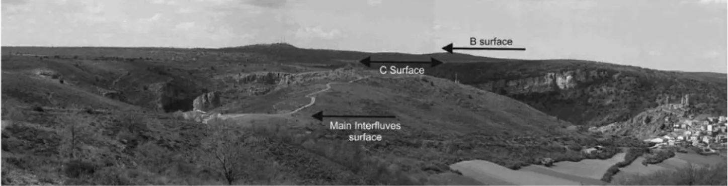
(8) 114. LANDSCAPE EVOLUTION AT THE RÍO DULCE NATURAL PARK. Fig. 4.- Location of the main planation and correlative sedimentary surfaces, and lines for topographic profiles of the surfaces shown in Fig. 5 (arrowed lines. and stars). BS, B surface; CS, C surface; MiS, Main interfluves surface. Numbers (1 to 6) refer to ravines and gullies shown in Fig. 8. Letters (A and B) refers to main capture events in the evolution of the Dulce River (see discussion section for details). For village names refer to Fig. 3.. aerial photographs to ascertain their continuity (Figs. 4 and 5); if correctly mapped, they can be used for conclusions on warping, tilting and faulting (De Brum Ferreira 1991; Lidmar-Bergström 1996; Bonow et al., 2006). Three major surfaces (Figs. 4, 5 and 6), and remains of a fourth one have been recognized and. mapped. Gladfelter (1971) nomenclature for the three upper surfaces is followed in this paper: A surface, the higher and oldest surface, but since in studied and adjacent areas there are only two control points, its presence is only tentative and in any case it can be considered dismantled in the studied area, being repre-. Fig. 5.- Topographic profiles of the planation and correlative sedimentary surfaces, and control points for each surface (stars in Fig. 4). Profiles extend from the Tagus-Ebro divide (right) to the Tagus Basin (left), both extremes are located several km outside studied area for a complete description of these surfaces (for a general trend of the entire profiles see Fig. 1); the precise location of the profiles in the studied area is shown in Fig. 4. Local names and heights (meters above sea level, masl) are from the 1:25,000 topographic map of Spain (IGN). Revista de la Sociedad Geológica de España, 29(1), 2016.
(9) José. F. García-Hidalgo, Álvaro García Quintana, Rocío Giménez, Miguel Aguilar Larrucea. sented by residual reliefs; B surface; and C surface the lower (Figs. 4, 5 and 6). Both B and C surfaces show a similar concave profile in the headward part of the Ranges and a more or less constant dip towards the basin (Fig. 5); being separated by scarp slopes and rolling areas with drops of 12 to 30 m. Finally, the lowermost surface is named here “Main interfluves surface” (Figs. 4, 5 and 6), being located at heights 15 to 35 m below C surface, with a smaller dip towards the Tagus Basin (Fig. 5), it corresponds to the older interfluves of the main regional rivers (Henares-Cañamares divide, 1,050 masl; Dulce-Henares divide, 1,030-1,045 masl; and Henares-Salado divide, 1,025-1,044 masl). Although now it is generally accepted that planation surfaces of regional extent are inevitably diachronous and might be influenced by changes in climate, among other causes (Veldkamp 1996; Coltorti et al., 2007), surfaces in the studied area really are not very extensive; maximum length is about 25 km from the Tagus-Ebro divide to the Tagus basin, suggesting that diachrony could be short and that they can be reconstructed from their remnants, considering them as surfaces with basinwards small slope (as really they are, Fig. 5) and assuming a non-eroded topography (Ollier 1981). The presence of erosional scarps separating the remnants also favours the correlation on the basis of the surface height (Fig. 6). Correlation of these surfaces with their most probably sedimentary correlative surfaces in the Tagus Basin show a crossing in the profiles (Fig. 5), which suggests that older erosion surfaces (B and C surfaces) have been faulted or dislocated by tectonic thrust structures. The presence of thrust and folds (probably representing blind thrusts) at the Iberian Ranges-Tagus Basin boundary, tilted Neogene sediments, and the local unconformities of the different Tertiary sedimentary cycles (Calvo et al., 1996; Alonso et al., 2004) support such interpretation. Since much of the tectonic activity could be related to the active thrusts in the Alpine front of the Iberian Ranges, an erosion surface could develop over a period of time and later be tectonically elevated during short orogenic pulses. Then, when the next erosion surface, at a lower height in the Iberian Ranges, starts to form, the erosion of the older surface takes place, mainly due the incision of a rejuvenated fluvial system (as suggested by the presence of a concave profile in the headward areas of the surfaces; see Fig. 5).. 115. Correlatively, the Tagus Basin acted as a foreland, closed endorheic basin, where the stacking of sedimentary units took place whereas erosion surface developed at the Iberian Ranges. Closed endorheic basins usually show a drainage network consisting of alluvial fan or fluvial systems at the basin border that feed lakes and fluvial systems located along the centre of the basin (Leeder and Jackson 1993). Erosion surfaces in the Ranges should grade laterally to sediments in the Basin, but these sediments will be consequently covered by the next sedimentary stage originated by the next tectonic activity in the Ranges. This positive feedback will be maintained whereas the Basin remained as a closed system. Once the Basin is captured, the local base-level lowering produced by the capture, stimulates development of an aggressive drainage network that tends to excavate the endorheic infill of the basin by headward erosion (Harvey and Wells 1987). This change should be marked by the presence of an erosive surface that grades laterally to the younger flat-lying sediments in the Basin, with its age usually being correlative with the beds located at the same height. Thus, the Tertiary sedimentary record and the landscape units of the BRDNP allow us to establish the succession of erosive and sedimentary events that shaped the landscape of this area during late Neogene times. The older remains of a suggested previous erosion surface in this region (A surface) are located about 1,2001,290 masl. This surface is recorded as isolated reliefs that break the otherwise flat upland plains, being preserved most prominently along the Ebro-Tajo-Duero drainage divide (such as Sierra Ministra, 1,312 masl) and as small fragments across the Iberian Ranges. This older surface can be a polygenic surface, preserving parts of more than one surface on resistant units of early Jurassic or late Cretaceous age. It corresponds to the “Dachfläche” (Schwenzner 1937),”A” (Gladfelter 1971), and “S1” (Gutiérrez Elorza and Gracia 1997) erosion surface; following these authors it has mid Miocene to late Miocene age and its correlation with the sedimentary record of the Tagus Basin is not fully understood. It is probably related with sedimentation of detrital facies in the lower sequence of the “Intermediate Unit” (Calvo et al., 1996). In the BRDNP a small remain of this surface is located in the “Cerro San Cristóbal” (Fig. 7a) on Cretaceous rocks at 1,214 masl, being mapped as Residual relief (I.a.1) unit (Fig. 3).. Fig. 6.- Field view of the three main erosive surfaces in the studied area, near Pelegrina village (right). Revista de la Sociedad Geológica de España, 29(1), 2016.
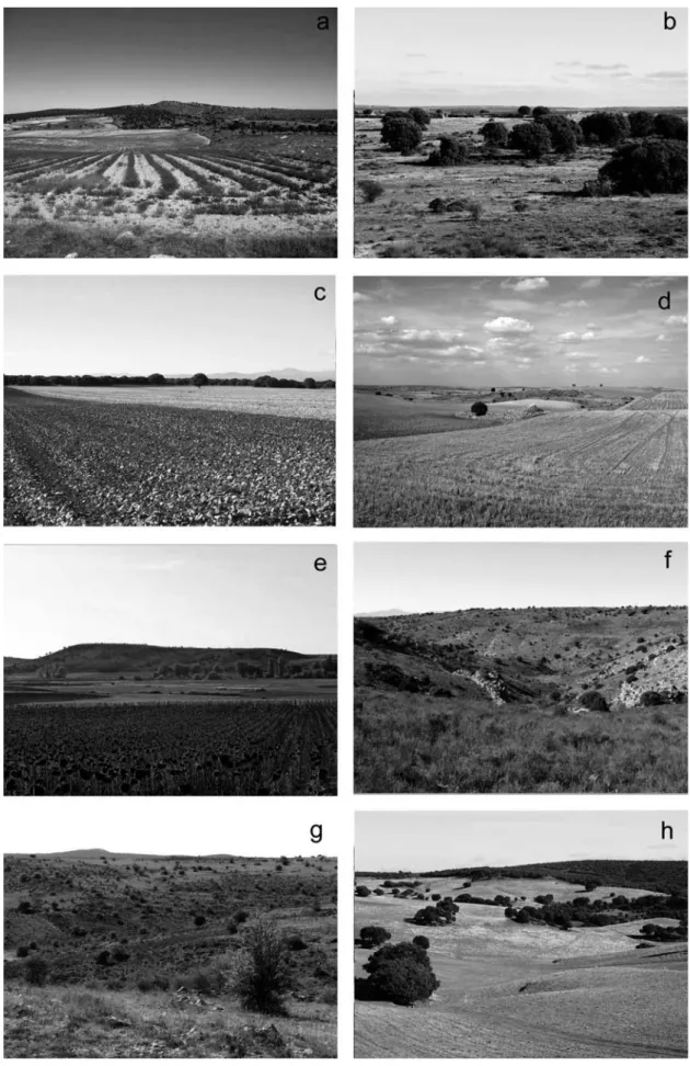
(10) 116. LANDSCAPE EVOLUTION AT THE RÍO DULCE NATURAL PARK. Fig. 7.- Visual sceneries of the High plains (a to e), and Tributaries (f to h) of the Valleys and gorges landscape systems. a, residual hill (San Cristobal hill, 40º57’49’’N-02º40’45’’W, view to N; see Fig. 2); b, Upland plain (Las Angeruelas plain, 41º01’32’’N-02º33’03’’W, view to N; see Fig. 2); c, Plateaus (Mirabueno plateau, 40º56’14’’N-02º43’26’’W, view to W; see Fig. 2); d, dissected upland plains (campiña de San Pelayo, 40º59’14’’N-02º38’19’’W, view to NE); e, upland plain remnants (La Huelga hill, 41º02’50’’N-02º31’38’’W, view to WNW); f, large gullies (Arroyo del Ceño, 41º01'51''N-02º40'07''W, view to NW); g, small ravines (Arroyo Valdeperutun, 41º10’26’’N-02º36’41’’W, view to SW); h, rolling areas (El Cerrillar; 40º58’51’’N-02º43’58’’W, view NE). Revista de la Sociedad Geológica de España, 29(1), 2016.
(11) José. F. García-Hidalgo, Álvaro García Quintana, Rocío Giménez, Miguel Aguilar Larrucea. The second (B) surface in this region is located about 1,270-1,155 masl (Figs. 4, 5 and 6), on resistant units of early Jurassic and late Cretaceous age. This surface is the largest and most visible erosive surface across the Iberian Ranges, being considered the “Main erosive surface” of the Iberian Ranges (Peña et al., 1984) (1 in Fig. 10 and 11). In the studied area it is partially preserved as irregular fragments of 5 to 30 km 2 (Figs. 7b and 7c), which allow its reconstruction. It was not an entirely flat surface; and there was a connection with the older A surface through glacis surfaces. It can be related to the “M3” (Schwenzner 1937), “B” (Gladfelter 1971), and “S2” (Gutiérrez Elorza and Gracia 1997) erosion surfaces. The age and correlation with the sedimentary record of the Tagus Basin is different depending on the authors; in the vicinity (east) of Algora (Fig. 4) conglomerates attributed to the “Upper Unit” by Rios et al. (1988) are clearly tilted and, by height and location regarding the different surfaces in that area, they should really be considered older (“Intermediate” unit) and thus related to B surface development. If B surface is related to the top of the “Intermediate” unit (as shown in Fig. 5), it has a mid Vallesian age (Alonso Zarza et al., 2004), and it probably has a slight tectonic deformation being slightly tilted to the SW. The crossing with the C surface (Fig. 5) suggests the presence of an active tectonic in the thrust faults at the boundary of the Iberian Ranges and the Tagus Basin (Figs. 10 and 11). The Dissected upland plains (I.c.4; Table 1) landscape in this area (Rd unit, east of Algora; Figs. 3 and 7d) can be partially considered as a pre-B surface exhumed palaeorelief, which was covered by coarse sediments (conglomerates) being part of the apex of the common alluvial fans of the upper sequence of the “Intermediate unit” (Calvo et al., 1996), deposited in this part of the Basin during late Miocene times (AragonianVallesian). Its age, thus, appears to be Vallesian and correlative to the top of the lower Paramos limestone sedimentation in the Tagus Basin (1 in Fig. 10). In the BRDNP B surface is also located in the eastern area forming part of the Upland plains (I.b.2; Table 1) unit (Figs. 3, 6 and 7b). Transition from B to C surfaces is irregular with a rolling plain transition area rather than exhibiting marked rises or scarps (Rd unit in Torremocha area; Fig. 3). The dissected upland plains (I.c.4; Table 1) are then a polygenetic landscape unit originated by erosion and incision on these upland surfaces along different times of landscape development. The third (C) erosive surface is located at 1,2001,060 masl (Fig. 4), being preserved both at the top of the resistant sediments of Neogene carbonates (upper Paramo Fm) as a landscape Plateau unit (Fig. 7c); and on the resistant sediments of Early Jurassic or Late Cretaceous age, along larger parts of the studied area as a High plain landscape unit (Figs. 4, 6 and 10b). This is the largest and most visible surface along the Tagus Basin, extending more than 115 km south-westwards to. 117. the region called the “Alcarria”. It is usually interpreted as a complex polygenic surface of erosion and corrosion. It corresponds to the “M2” (Schwenzner 1937), “C” (Gladfelter 1971), and “S2-S3” (Gutiérrez Elorza and Gracia 1997) erosive surfaces. In the BRDNP this surface is located in the extreme SW as part of the Plateaus unit (I.b.3, Table 1; Fig. 7c). It can also be located in the central areas forming part of the upland plains landscape type (I.b.2, Table 1) and as part of the dissected upland plains (I.c.4, Table 1) (Figs. 10b and 11b; see also Fig. 6); the inclusion of this surface together with other older surfaces to form a mainly flat landscape area has also been mentioned by Gladfelter (1971). Its correlative sediments in the Tagus Basin have an uppermost Turolian age (latest Miocene; according to Fig. 6.23 in Alonso-Zarza et al., 2004). It has been also slightly uplifted due to tectonic movements in the thrust faults at the Iberian Ranges-Tagus Basin boundary (Fig. 5). On the other hand, C surface is entrenched on the B surface between 17 and 52 m in the apparently undeformed areas of the Iberian Ranges (Fig. 5), and the compacted thickness of the Upper Unit in the Tagus Basin is about 35-36 m. At the end of the Miocene and during the endorheic– exorheic transition of the Tagus Basin, paleo-karstification processes occurred in Mesozoic limestones exposed both in B and C surfaces, and also in the upper Paramo limestones (Cañaveras et al., 1996). The onset of the karstic system in many places of the study and surrounding areas took place with the development of polje-like valleys on B surface (Fig. 11b). The lowering of the table water caused doline and polje development, not related to any fluvial system (Fig. 11b). Later, during the cooler and moister phases of the Pliocene and Quaternary, karst development and enlargement of karstic features (such as polje-like valleys) have been active processes in landscape development. Valleys and gorges of Pliocene and Quaternary age. They correspond to the front of the different Pliocene and Quaternary erosive fluvial processes on the Neogene High plains. Incompetent beds, such as the late Triassic clays or the early Cretaceous sands, are very prone to erosion by fluvial processes, and thus older erosive surfaces are barely preserved upon these units. Tertiary deposits are also less resistant rocks and easy to erode although there are occasionally flat surfaces well preserved on Tertiary sandstones and conglomerates. Quaternary valleys and gorges are the areas with the most active soil erosion and thus are sensitive areas for BRDNP conservation. They can be subdivided into complex areas composed of the tributaries of the current fluvial network (II.a), and the main valleys of the fluvial network (II.b) (Table 1, Figs. 8 and 9). Prolonged dissection and modelling through fluvial network tributaries has produced the relief of the Tributaries landscape (II.a, Table 1), which occupy a large Revista de la Sociedad Geológica de España, 29(1), 2016.
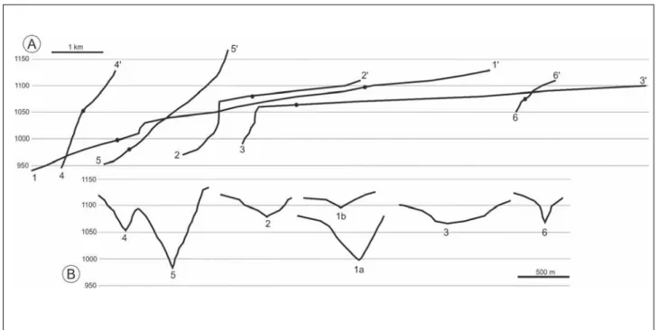
(12) 118. LANDSCAPE EVOLUTION AT THE RÍO DULCE NATURAL PARK. Fig. 8.- Topographic profiles (A) and cross-sections (B) of selected tributaries of the studied area (for location see Fig. 4). 3-3’, correspond to the Torremocha valley, an Hanged valley interpreted as originated in relation to the Main interfluves surface (see Fig. 4); 1-1’ and 2-2’ correspond to tributaries of the Henares (1) and Dulce (2) Rivers with prominent waterfalls and upper reaches with similar slope but steeper than the Torremocha valley, suggesting a subsequent entrenchment phase with a lower base level than the Torremocha valley. 4-4’ and 6-6’ correspond to small ravines with a convex profile and cross section (6-6’), suggesting the presence of two entrenchment phases (the older correlative with the upper reaches of 1 and 2); 5-5’, a large gully with a concave profile representing the younger entrenchment phase in studied area. 1, Arroyo del Ceño; 2, Arroyo de la Veranosa; 3, Torremocha valley (hanged valley; see Figs. 2 and 9a); 4, Arroyo de la Torre (large gully, see Fig. 8f); 5, Arroyo de Valdequemado (small ravine, see Fig. 8g); 6, Barranco del Águila (small ravine). Local names and heights (meters above sea level, masl) are from the 1:25,000 topographic map of Spain (IGN).. part of the BRDNP. They are spatially located between the High Plains and the Main fluvial Valleys, although there are some local areas located within the High Plains. Four landscapes can be recognized in this landscape type (Table 1): a) Large gullies (II.a.6, Table 1) (Fig. 7f; 5 in Fig. 8a and b), b) Small ravines (II.a.7, Table 1) (Fig. 7g; 4 and 6 in Fig. 8a and b), c) Rolling plains (II.a.8, Table 1) (Fig. 7h), and d) Hanged valleys (II.a.9, Table 1) (Fig. 9a; 3 in Fig. 8a and b). There are three prominent differences between the gully and ravine types: i) the degree of incision is higher in the case of the large gullies, this is clearly seen when they are close to each other (4 and 5 in Fig. 8b; see also Fig. 4 for location of these tributaries); ii) large gullies have a concave profile (5 in Fig. 8a), meanwhile small ravines have a convex profile (4 and 6 in Fig. 8a); and iii) in some cases small ravines also have a convex cross-section (6 in Fig. 8b) with a prominent break in slope, suggesting the existence of two incision periods for this tributaries. Erosion of Neogene High plains by a fluvial network with a lower base level along Pliocene and Quaternary times, has allowed a more aggressive dissection and denudation of the underlying materials, resulting in the increased local relief and the steeper slope forms of the fluvial valleys (II.b, Table 1). These valleys are the most valued landscape types in the Iberian Ranges and thus several gorges and canyons are currently protected as PNAs, the BRDNP being one of them. They Revista de la Sociedad Geológica de España, 29(1), 2016. bear a high social value and a high attention to their management (Table 1). All of them are broadly similar but quite different in detail; the methods developed in this study can be applied directly to them. Fluvial network (exorheic) entrenchment started in the Pliocene. This is clearly shown in the studied area by the presence of entrenched plains and valleys on the latest Miocene sediments (Figs. 10c and 11c). Thus, a third erosive surface is recorded as Main interfluves surface located at 1,075-1,040 m (partially corresponding to the D surface of Gladfelter 1971)(Fig. 11c). Its location and height point out to a fluvial origin, although lacking alluvial sediments in the studied area. It also has a different origin than B and C surfaces (as it has also been mentioned by Gladfelter 1971, for his D surface). There probably was only a single river flowing from the Ranges to the Basin in this area (Fig. 11c) because the two main fluvial valleys that drain the studied area (the Dulce and the Henares Rivers) are very close with almost tangential courses. In fact, in the surroundings of La Cabrera, both are aligned, the Henares from Baides to La Cabrera and the Dulce from La Cabrera to Pelegrina (A in Fig. 4). At La Cabrera both are separated by a flat interfluve at about 1,046 masl corresponding to the height of the Main interfluves surface in that area (Fig. 5). Thus, the lower reaches of the Dulce River (at Mandayona, Fig. 4), if they existed, probably were not connected to the upper reaches from La Cabrera..
(13) José. F. García-Hidalgo, Álvaro García Quintana, Rocío Giménez, Miguel Aguilar Larrucea. 119. Fig. 9.- Landscape sceneries of the Hanged valley (II.a Tributaries) and, the Main fluvial valleys (II.b) of the Valleys and gorges landscape systems. a, hanged valley (Torremocha valley, 41º00'15N-02º37'04''W, view to E; see Figs. 2 and 3); b, asymmetric valley (Dulce River near to Jodra, 41º02’49’’N-02º34’10’’W view to SW; see Fig 2); c, symmetric valley (Dulce River in Valcabril, 41º01’31’’N-02º36’16’’W view to NE; see Fig. 3); d, symmetric canyon-like valley (Dulce River east of Pelegrina, El Corrompido, 41º00'32''N-02º37'59''W, view to NE; see Fig. 3); e, terraced valley (Dulce River near Enmedio Hill, 41º01’25’’N-02º36’17’’W, view to SW; see Fig. 3); f, flat-bottomed valley (Dulce River west of Pelegrina, 41º01’08’’N-02º37’20’’W view to E; see Fig. 3); g, open valley (Dulce River near La Cabrera, 41º00'40''N-02º40'58''W, view to SSE; see Fig. 3); h, major valley (Dulce River near Mandayona, 40º57’59’’N-02º44’12’’W, view to SW; see Fig. 3). Revista de la Sociedad Geológica de España, 29(1), 2016.
(14) 120. LANDSCAPE EVOLUTION AT THE RÍO DULCE NATURAL PARK. Fig. 10.- Landscapes evolution of studied area (cross-section view) from Neogene to Holocene (present) based in landscape units (Fig. 3) and topographic profiles (Figs. 5 and 8). a) Late Neogene, B surface development after a compressive stage in the Iberian Ranges, correlative with Intermediate unit sedimentation (lower Paramos limestone unit, dark grey) in the Tagus Basin. b) latest Neogene, C surface development at lower heights than B surface after renewed tectonic activity in the Iberian Ranges, correlative with Upper unit sedimentation (upper Paramos limestone unit, light grey) in the Tagus basin. c) Pliocene, onset of the exorheic transition of Tagus Basin and Main interfluves surface development. d) Early-Mid? Pleistocene, first phase of fluvial entrenchment by the present fluvial network, the Pliocene Torremocha valley is abandoned, development of new tributaries (1 and 2 in Fig. 8) and small ravines (4 and 6 in Fig. 8). e) Mid-Late?Pleistocene, second phase of fluvial entrenchment, small ravines (6 in Fig. 8) and many tributaries (1 and 2 in Fig. 8) are reincised; the Dulce River takes its present profile. See also Figs. 2 and 11.. The origin of the Torremocha valley (Figs. 3 and 9a) is also related to this entrenchment. This is a large and wide valley, which is presently recognized as a hanged valley landscape (II.a.9, Table 1; Fig. 9a; 3 in Fig. 8a and b), only slightly entrenched in the dissected upland plains and disconnected from the present fluvial drainage, being occasionally connected through a large waterfall of about 80 m in height (3 in Fig. 8). The height of the mouth of this valley corresponds to the height of the Main interfluve surface (1,075 masl). So it is postulated here that this valley is the last remaining on the Ranges of a Pliocene fluvial network. These processes are also correlated outside the studied area with the lower and younger “Rañas” (siliceous gravels and sandy muds), which are also entrenched on the latest Miocene sediments (Pérez-González and Gallardo, 1987), having the same age (Middle Villafranchian according to Pérez-González and Gallardo, 1987). Thus, the Main interfluves surface probably has an age of about 1.6 to 1.8 Myr, Revista de la Sociedad Geológica de España, 29(1), 2016. and since it is entrenched around 20 to 37 m below C surface (Figs. 5 and 6) Furthermore, the capture of the polje-like valleys (Pelegrina and Jodra valleys, Fig. 3) originating the flat-bottomed valleys (II.b.12, Table 1; Fig. 9f) and other complex valleys developed on non-resistant units of Keuper and early Jurassic age also started with the entrenchment of the fluvial network (Figs. 10c and 11c). All these valleys have an ellipsoidal shape and are wider than the downstream reaches of the same river (García-Quintana et al., 2005). The capture of the Jodra polje-like valley took place later than the other valleys, because north of the village of Jodra there is an abandoned, meandering valley, which is in continuity with the main trend of the Dulce River (B in Fig. 4), and this abandoned valley was probably an early Pleistocene course of the Dulce River. The lowering of the base level by fluvial entrenchment reactivates karst and fluvial captures; similar erosive structures are recognized elsewhere in the Iberian Ranges..
(15) José. F. García-Hidalgo, Álvaro García Quintana, Rocío Giménez, Miguel Aguilar Larrucea. Pleistocene fluvial development in this area was also a complex process with several shifts in fluvial courses, meandering and karstic development due to the continuing water table lowering (including doline formation) (Figs 10d and e, and Fig. 11d and e). This was a major pulse of rapid entrenchment, which caused a 40-50 m lowering of the Dulce and Henares courses, originating the abandonment of the Torremocha valley, and producing the waterfalls located at 1,030-1,065 masl (2 and 3 in Fig. 8). The development of small ravines (II.a.7, Table 1), and the upper reaches of many tributaries located in the dissected upland plains are interpreted to be originated during this phase (Figs 10d and 11d). They are only partially related to the current headward erosion of the Quaternary Dulce and Henares fluvial systems (1 and 2 in Fig. 4); being connected with these fluvial systems through large waterfalls when resistant rocks are close to the junction (2 in Fig. 8), or with prominent knick points with high slopes when not (1 in Fig. 8), suggesting that these upper reaches represent parts of a fluvial network originated when the base level of regional rivers was higher than the current one. The gradient of these valleys, however, are slightly higher than in the “hanged valleys” (compare 1 and 2, with 3 in Fig. 8), which suggests that their mouths were located at lower heights and point out that they were younger than the hanged Torremocha valley. Related also with this second pulse of entrenchment is the capture, by headward erosion, of the upper reaches of the Dulce River by its present lower reaches (La Cabrera capture) (Fig. 11d). A third phase of rapid entrenchment at the late Pleistocene caused a succeeding 20-30 m lowering of the fluvial courses and the fluvial drainage took its present form. The incised channels of many tributaries are, actually, the result of the timing and intensity of erosive forces, which acted at different base levels (compare cross-section of 4 and 5 in Fig. 8b, being both adjacent tributaries of the Henares river). With a lowered base level, new tributaries were consequently originated (large gullies, II.a.6, Table 1), or they were completely imposed on older ones, completely erasing their trace. Meanwhile renewed erosion from a lower base level started in the small ravines (Fig. 10e and 11e); originating thus the convex profile and break in slopes of these tributaries, which have not yet reached a full equilibrium along their longitudinal profile. The erosion leading to Rolling areas development (II.a.8, Table 1) in the Cainozoic sediments near Mandayona is also related to this phase (Fig. 11e). The entrenchment of the fluvial drainage is also clearly shown in the surroundings of Pelegrina. East of Pelegrina there is an interfluve that separates two different reaches of the Dulce River: the valley of the northern reach is wide, straight, and flat-bottomed, while the valley of the southern reach is narrow, winding and V-shaped. The Pelegrina interfluve has two erosive fluvial stretches located at 1,065 masl and at 1,015 masl. The current connection between these two reaches is at about 980 masl. All of them are interpreted as 3 successive connections between the two reaches, the oldest (1,065 masl) is at the same height as the. 121. Torremocha valley, and consequently its presumable age is Pliocene. The intermediate (1,015 masl) probably has an early Pleistocene age; and finally, the currently active one is considered of a late Pleistocene age. The recent (late Pleistocene-Holocene) fluvial dynamic of the Dulce river is clearly shown both by the presence of an abandoned meander at La Cabrera and by the presence of eroded dolines, developed only in Jurassic units and on the Upland plains, upstream of Pelegrina. Pleistocene-Holocene rates of fluvial entrenchment can be obtained from the difference between D surface (1,046 masl) and the present height of the Dulce River (which is about 915 masl NW Aragosa). Conclusions. An integrated model for landscape and landscape development in the “Barranco del Río Dulce Natural Park” (central Spain) was carried out first by the identification of landscapes and landscape units, and second with their compilation and classification in relation to the geological substratum (Table 1). Two major landscape systems were developed in the studied area: the “High plains” of Neogene age, and the “Valleys and gorges” of the Quaternary fluvial network, entrenched in the plains. Each system can be further subdivided into two or three landscape types depending on the degree of erosion: Main reliefs (I.a), flat terrains (I.b) and dissected flat terrains (I.c) in the High plains; and tributaries(II.a) and the valleys of this fluvial network (II.b) in the Quaternary valleys and gorges. Plain surfaces that include larger parts of the Iberian Ranges and the Tagus Basin at different heights are one of the most outstanding geomorphologic features of the studied area (Fig. 6); these surfaces can be divided according to their geological nature: planation surfaces developed mainly on Palaeozoic and Mesozoic rocks and sedimentation surfaces on Neogene rocks. Three major surfaces have been recognized and mapped (B, C and main interfluves surfaces from the highest to the lowest), each show a concave profile in the headward part and a more or less constant dip towards the Tagus Basin; being separated by scarp slopes and rolling areas with drops of 10 up to 50 m. The Valleys and gorges of Quaternary age correspond to the front of the different Quaternary erosive fluvial processes on the Neogene High plains by a fluvial network with a lower base level, which has originated a more aggressive dissection and denudation of the underlying materials, resulting in increased local relief and steeper slope forms. Quaternary Valleys and gorges are the areas with the most active soil erosion and thus are sensitive areas for BRDNP conservation. Prolonged dissection and modelling through fluvial network tributaries has produced the relief of the Tributaries, which are spatially located between the High Plains and the Main fluvial Valleys. These valleys are the most valued landscape types in the Iberian Ranges and thus several gorges and canyons are currently protected as PNAs, the BRDNP being one of them. They bear a high social value and high attention to their management (Table 1). Thus, for the management of the BRDNP by non-scientific technicians and politiRevista de la Sociedad Geológica de España, 29(1), 2016.
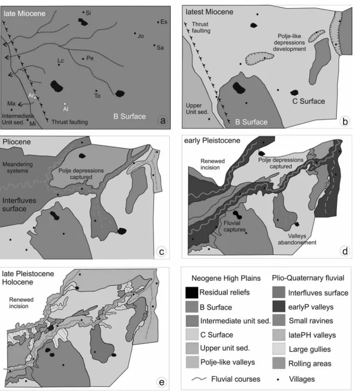
(16) 122. LANDSCAPE EVOLUTION AT THE RÍO DULCE NATURAL PARK. cians (classification, valuation, conservation, reclamation, etc.), and also for scientific and non-scientific use by the general public (visits, educational activities, etc.), fieldbased landscape units have been developed and mapped. These units have then been integrated with other geological data in order to demonstrate the landscape develop-. ment during late Neogene-Quaternary times and to establish the recent history of the landscape based on the relative age of its landscapes. The internal properties of landscape units have a crucial role in their definition and mapping. Landscape units, like rock units, however, bear some subjectivity both in. Fig. 11.- Landscape evolution of studied area (map view) from Neogene to present based in landscape units (Fig. 3), planation surfaces (Figs. 4, 5 and 6) and fluvial entrenchment. a) late Miocene, B surface development, only some residual reliefs stand on this surface. b) latest Miocene, C surface development. The lowering of base level (and water tables) triggered the development of karstic processes (polje-depressions, dolines, etc.) on the Jurassic and Cretaceous calcareous areas. c) Pliocene, the studied area becomes exorheic; development of the Main interfluves surface, the Dulce and Henares Rivers are connected (A in Fig. 4); development of the Torremocha valley; some polje-depressions are captured and become valleys of the fluvial network. d) early-mid? Pleistocene (earlyP), fluvial entrenchment and renewed incision, the Pliocene Torremocha valley is abandoned, small ravines and tributaries development. The lower Dulce captures the upper Dulce with development of the present fluvial network. Jodra polje captured and abandonment of the older upper reaches of the Dulce River (B in Fig. 4). e) mid?-late Pleistocene and Holocene (latePH), renewed incision and large gullies development; rolling areas development (probably started in D). For village names (only shown in a for simplicity) see Fig. 3. Revista de la Sociedad Geológica de España, 29(1), 2016.
(17) José. F. García-Hidalgo, Álvaro García Quintana, Rocío Giménez, Miguel Aguilar Larrucea. their definition and in their boundaries location. At a given scale, the use of geological differences and lineations, on the one hand, often produces landscape discontinuities and boundaries; and, on the other hand, the land surface may also exhibit topographic discontinuities, which can be recognised as natural boundaries of landscape units. In any place on the Earth’s surface, the overlapping of geomorphic processes over time may originate some fuzzy landscape boundaries, which might be problematic to recognize. We recognize that, as in many geological maps, landscape type definition and landscape map construction bears some subjectivity in establishing some of the boundaries of the landscape units. Thus, three types of landscape boundaries have been distinguished based both on the identification of natural boundaries, with maximal change of genetic, geometric and process character and depending on the visual perception of the entire landscape unit and its composition. 1) Visual boundaries are clear and obvious landscape boundaries, like the line that separates a plain from an entrenched valley; an observer located either on the plain, on the boundary or in the valley perceives a very different landscape. 2) Compositional boundaries separate areas with different landscape composition, which in both vertical and scenic views are perceived as clearly different; but lacking a clear definite landscape border or a visual border line. They limit areas with different land uses (due to different lithology and/or tectonic structure, and whose different mechanical and/or hydrological properties are different), which provide a contrast of textures and colours that in a panoramic view prevail on moderate differences in landscapes. 3) Conventional boundaries are the most unclear and fuzzy boundaries, when there is not a definite, clear, visual or geological boundary between two contiguous landscape areas; they are boundaries with a more imprecise position and where the location of the observer, or the scale of observation might change the precise boundary location, making thus “conventional” its specific location, but not its real existence and, thus, for mapping purposes conventional limits should be established, trying to draw the most valid boundary from a visual point of view. The results of the landscape mapping and geomorphic analyses reveal the landscape evolution in the studied area during the late Neogene and Quaternary. Miocene landscape evolution occurred mainly through the development of planation surfaces (B and C surfaces), forming the Neogene High plains, which were contemporary with tectonic uplift and erosion of the Iberian Ranges, and sedimentation in the Tagus Basin. Fluvial network (exorheic) entrenchment started in the Pliocene, a third erosive surface is recorded as Main interfluves surface. There was probably only one main river flowing from the Ranges to the Basin in this area; because the two main fluvial valleys draining the studied area (Dulce and Henares Rivers), are aligned with a tangential course. The lowering of the base level by fluvial entrenchment reactivates karst and fluvial processes in the Ranges with the development of fluvial courses (the hanged valley of Torremocha), and the capture of the polje-like flat-bottomed valleys.. 123. Pleistocene fluvial development was a complex process with several shifts in fluvial courses, meandering and karstic development due to the continued water table lowering (including doline formation). A second pulse of fluvial entrenchment caused a base level lowering of Dulce and Henares Rivers. Related to this phase are the abandonment of the Torremocha valley, the development of new tributaries (small ravines) and the capture of the upper reaches of the Dulce River by its present lower reaches. A third phase of rapid entrenchment (late Pleistocene) caused a renewed lowering of base level and fluvial drainage took its present form. New tributaries were consequently originated (large gullies), and renewed erosion from a lower base level started in the small ravines. The presence of an abandoned meander at La Cabrera and minor karstic features show the recent (late Pleistocene-Holocene) fluvial dynamic of the Dulce River. Acknowledgements. This work includes some of the results obtained in Project PR3/04-12421 of the Universidad Complutense de Madrid, and Project CGL2004-02179BTF of the Dirección General de Investigación (Ministerio de Educación y Ciencia). The authors would like to thank Prof. José F Martín Duque (Universidad Complutense de Madrid) and an anonymous reviewer for their valuable suggestions and comments to improve the manuscript, and to the FITISPos translation service of the Universidad de Alcalá for revision of the English manuscript. References. Álvaro, M., Capote, R. and Vegas, R. (1979): Un modelo de evolución geotectónica para la Cadena Celtibérica. Acta Geológica Hispánica, 14: 172-177. Alonso-Zarza, A.M., Calvo, J.P., Silva, P.G. and Torres, T. (2004): Cuenca del Tajo. In: Geología de España (J.A. Vera, Ed). Madrid, SGE-IGME, 556-561. Anadón, P. and Moissenet, E. (1996): Neogene basins in the Eastern Iberian Range. In: Tertiary Basins of Spain: The Stratigraphic Record of Crustal Kinematics (P.F. Friend, and C.J. Dabrio, Eds). Cambridge University Press, Cambridge, 68-76. Bonow, J.M., Lidmar-Bergström, K. and Japsen, P. (2006): Palaeosurfaces in central West Greenland as reference for identification of tectonic movements and estimation of erosion. Global and Planetary Change, 50: 161-183. Calvo, J.P., Alonso Zarza, A.M., García del Cura, M.A., Rodríguez Aranda, J.P. and Sanz, M.E. (1996): Sedimentary evolution of lake systems through the Miocene of the Madrid Basin: paleoclimatic and paleohydrological constraints. In: Tertiary Basins of Spain: The Stratigraphic Record of Crustal Kinematics (P.F. Friend and C.J. Dabrio, Eds). Cambridge University Press, Cambridge, 272-277. Cañaveras, J.C., Calvo, J.P., Hoyos, M. and Ordoñez, S. (1996): Paleomorphologic features of an intra-vallesian paleokarst, Tertiary Madrid Basin: significance of paleokarstic surface in continental basin analysis. In: Tertiary Basin of Spain: The Stratigraphic Record of Crustal Kinematics (P.F. Friend and C.J. Dabrio, Eds). Cambridge University Press, Cambridge, 278-284. Revista de la Sociedad Geológica de España, 29(1), 2016.
(18) 124. LANDSCAPE EVOLUTION AT THE RÍO DULCE NATURAL PARK. Casas-Sainz, A.M. and Cortés-Gracia, A.L. (2002): Cenozoic landscape development within the Central Iberian Chain, Spain. Geomorphology, 44: 19-46. Cendrero, A., Nieto, M., Robles, F., Sánchez, J., Díaz de Terán, J.R., Francés, E., González Lastra, J.R., Boluda, R., Garay, P., Gutiérrez, G., Jiménez, J., Martínez, V., Molina M.J., Obartí, J., Pérez, A, Pons, V., Santoyo, A. and Stubing, G. (1986): Mapa Geocientífico de la provincia de Valencia. Diputación Provincial de Valencia, Valencia, 71 p. Coltorti, M., Dramis, F. and Ollier, C.D. (2007): Planation surfaces in Northern Ethiopia. Geomorphology, 89: 287-296. De Brum Ferreira, A. (1991): Neotectonics in Northern Portugal. A geomorphological approach. Zeitschrift fuer Geomorphologie, Supplementbaende, 82: 73-85. Dehn, M., Gärtner, H. and Dikau, R. (2001): Principles of semantic modeling of landform structures. Computers & Geosciences, 27: 1005-1010. De Vicente, G., Vegas, R., Muñoz Martín, A., González-Casado, J.M., Carbó, A., Álvarez, J., Cloetingh, S., Andriessen, P., Elorza, F.J. and Olaiz, A. (2004): El Sistema Central. In: Geología de España (J.A. Vera, Ed). SGE-IGME, 621-625. Eder, W. and Patzak, M. (2004): Geoparks -geological attractions: A tool for public education, recreation and sustainable economic development. Episodes, 27: 162-164. García-Quintana, A., Martín-Duque, J.F., González-Martín, J.A., García-Hidalgo, J.F., Pedraza, J., Herranz, P., Rincón, R. and Estévez, H. (2005): Geology and rural landscapes in Central Spain (Guadalajara, Castilla-La Mancha). Environmental Geology, 47: 782-794. Giles, P.T. and Franklin, S.E. (1998): An automated approach to the classification of slope units using digital data. Geomorphology, 21: 251-264. Gladfelter, B.G. (1971): Meseta and campina landforms in central Spain; a geomorphology of the Alto Henares Basin. Research Paper, University of Chicago, Department of Geography, 130: 204 p. Godfrey, A.E. (1977): A physiographic approach to land use planning. Environmental Geology, 2: 43-50. Gracia-Prieto, F.J., Gutiérrez-Elorza, M. and Leránoz-Istúriz, B. (1988): Las superficies de erosión neógenas en el sector central de la Cordillera Ibérica. Revista de la Sociedad Geológica de España, 1: 135-142. Gutiérrez Elorza, M. and Gracia, F.J. (1997): Environmental interpretation and evolution of the Tertiary erosion surfaces in the Iberian Range (Spain). In: Palaeosurfaces: Recognition, Reconstruction and Palaeoenvironmental Interpretation (M.. Revista de la Sociedad Geológica de España, 29(1), 2016. Widdowson, Ed). Geological Society Special Publication, 120: 147-158. Gutiérrez, F., Gracia, J. and Gutiérrez, M. (1996): Consideraciones sobre el final del relleno endorreico de las fosas de Calatayud y Teruel y su paso al exorreísmo: implicaciones morfo-estratigráficas y estructurales. In: IV Reunión Nacional de Geomorfología, Sociedad Española de Geomorfología, 2343. Guzzetti, F. and Reichenbach, P. (1994): Towards a definition of topographic divisions for Italy. Geomorphology, 11: 57-74. Harvey, A.M. and Wells, S.G. (1987): Response of Quaternary fluvial systems to differential epeirogenic uplift: Aguas and Feos River systems, southeast Spain. Geology, 15: 689-693. Leeder, M.R. and Jackson, J.A. (1993): The interaction between normal faulting and drainage in active extensional basins, with examples from the western United States and central Greece. Basin Research, 10: 7-18. Lidmar-Bergström, K. (1996): Long-term morphotectonic evolution in Sweden. Geomorphology, 16: 33-59. Ollier, C. (1981): Tectonics and Landforms. Longman, London, 324 p. Peña, J.L., Gutiérrez, M., Ibáñez, M.J., Lozano, M.V., Rodríguez, J., Sánchez, M., Simón, J.L., Soriano, M.A. and Yetano, L.M. (1984): Geomorfología de la Provincia de Teruel. Publicaciones del Instituto de Estudios Turolenses, Teruel, 149 p. Pérez-González, A. and Gallardo, J. (1987): La Raña al sur de la Somosierra y Sierra de Ayllón: un piedemonte escalonado del Villafranquiense medio. Geogaceta, 2: 29-32. Rios, L.M., Barettino, D., Racero, A. and Galera, J.M. (1988): Mapa Geológico de España 1:50.000, hoja nº 487 (Ledanca). IGME, Madrid. Schwenzner, J.E. (1937): Zur Morfologie des Zentralspanischen Hochlandes. Geogr. Abhandl., 3a Sr. Engelhorn, Stuttgart, 128 p. Simón, J.L. (1984): Compresión y distensión alpinas en la Cadena Ibérica oriental. Instituto de Estudios Turolenses, Teruel, 269 p. Veldkamp, A. (1996): Late Cenozoic landform development in East Africa: the role of near base level planation within the dynamic etchplanation concept. Zeitschrift fuer Geomorphologie, Supplementbaende, 106: 25-40.. MANUSCRITO RECIBIDO EL 14-01-2016 RECIBIDA LA REVISIÓN EL 3-03-2016 ACEPTADO EL MANUSCRITO REVISADO EL 13-03-2016.
(19)
Figure


+6


Documento similar
Over sixty billion euros of damages, six hundred and fifty victims and a great amount of structures with a significant value as to the architectural, historical, artistic and
Representation of the positive relationship among fruit abundance and frugivore activity (resource tracking) at local and landscape spatial scales, showing also the concordance
Encara que celebrem el món dels nous mitjans de comunicació com a proveïdors d’infor- mació científi ca i per tant d’una major democratització de la política científi
(C) lncRNAs can represent a bridge between the many layers of epigenetic gene regulation, interacting with, for example, histone modifiers or serving as ceRNAs for miRNAs; (D)
The synthesis and analysis of these properties were then featured by (i) the composition, geometry, and electronic and mag- netic structure of the exposed surfaces at the
In the previous sections we have shown how astronomical alignments and solar hierophanies – with a common interest in the solstices − were substantiated in the
The aims of this study were to use single-cell RNA sequencing (scRNA-seq) to map the transcriptional landscape and cellular dynamics of directed differentiation of human embryonic
In this paper, we analyzed raptors ’ foraging habitat selection in response to conventional roads and high ca- pacity motorways at the landscape scale, and compared their effects
