The problem of heterogeneous data fusion in a Smartland: Proposal for an ontological platform for integrating data
12
0
0
Texto completo
(2) ATICA2017. Obras Colectivas de Tecnología 24. Tecnología. Accesibilidad. Educar en la sociedad red. Luis Bengochea Martinez Nilber Javier Mosquera Perea Elena Campo Montalvo José Ramón Hilera González (Editores).
(3) ATICA2017: Tecnología. Accesibilidad. Educar en la sociedad red. Libro de Actas VIII Congreso Internacional sobre Aplicación de Tecnologías de la Información y Comunicaciones Avanzadas V Conferencia Internacional sobre Aplicación de Tecnologías de la Información y Comunicaciones para mejorar la Accesibilidad I Congreso Internacional Educar en la Sociedad Red: Realidad, Retos y Perspectivas. Católica del Norte Fundación Universitaria Medellín (Colombia) 25 al 27 de octubre de 2017.
(4) El libro “ATICA2017: Tecnología. Accesibilidad. Educar en la sociedad red” en el que se recogen las Actas del VIII Congreso Internacional sobre Aplicación de Tecnologías de la Información y Comunicaciones Avanzadas, de la V Conferencia Internacional sobre Aplicación de Tecnologías de la Información y Comunicaciones para mejorar la Accesibilidad y del I Congreso Internacional Educar en la Sociedad Red: Realidad, Retos y Perspectivas, editado por Luis Bengochea Martínez, Nilber Javier Mosquera Perea, Elena Campo Montalvo y José Ramón Hilera González, se publica bajo licencia Creative Commons 3.0 de reconocimiento – no comercial – compartir bajo la misma licencia. Se permite su copia, distribución y comunicación pública, siempre que se mantenga el reconocimiento de la obra y no se haga uso comercial de ella. Si se transforma o genera una obra derivada, sólo se puede distribuir con licencia idéntica a ésta. Alguna de estas condiciones puede no aplicarse, si se obtiene el permiso de los titulares de los derechos de autor.. Universidad de Alcalá Servicio de Publicaciones Plaza de San Diego, s/n 28801 Alcalá de Henares www.uah.es ISBN: 978-84-16599-50-9. Edición digital Fotografía de la portada: The International Space Station ISS is seen in this 30 second exposure as it flies over Elkton, VA early in the morning, Saturday, August 1, 2015. Photo Credit: (NASA/Bill Ingalls). Los contenidos de esta obra son responsabilidad exclusiva de sus autores y no reflejan necesariamente la opinión oficial de la Católica del Norte Fundación Universitaria, la Universidad de Alcalá ni de ninguna de las instituciones que han colaborado en la organización del congreso..
(5) ATICA2017: Tecnología. Accesibilidad. Educar en la sociedad red.. The problem of heterogeneous data fusion in a Smartland: Proposal for an ontological platform for integrating data José Antonio Gutiérrez de Mesa1, Donghui Shi2, José Aguilar3 and Nancy Cruz1,. Dpto. de Ciencias de La Computación, Universidad de Alcalá, Edificio Politécnico, 28801 Alcalá de Henares, España 2School of Electronics and Inf. Engineering Anhui Jianzhu University. Hefei, China. 3Universidad de Los Andes CEMISID. Mérida, Venezuela jantonio.gutierrez@uah.es; sdonghui@gmail.com; aguilar@uve.ve; nancy.cruz@edu.uah.es 1. Abstract. This paper presents a proposal for the intelligent territory platform based on ontologies. The platform can connect different types of agents which consist of sensors and devices acting as producers or consumers of information, and provide the real information for intelligent application. Ontology technologies can insure automatic information communication between agents and the systems. In our proposal, the intelligent platform can obtain data from these agents, and users can easily interact with the intelligent territory platform. The information of each agent is semantically represented as the standardized knowledge of the intelligent platform. Keywords: Intelligent Infrastructure; Ambient intelligence; Sensitivity to context; Smart City; ontology; SmartLand; Smart Objects.. 1. Introduction. The earth is a natural resource for sustaining human and other natural species. Territories play an important role in the agricultural, residential and environmental progresses in a country. With the growth of population, the changes of cultivated and industrial areas, it is more important to improve territory management. Information and communication technologies (ICT) give us the possibility. SmartLand extends the concept of "Smart Cities", which focuses on the cities. Its target is establishing an intelligent territory. An intelligent system can provide us with maximum accuracy, accessibility and portability for the management in a given territory. In the system, Geographical Information System (GIS) and Global Positioning System (GPS) are used to store the events that occurred in different areas in the land. They can help us make decisions in a reasonable manner. From the beginning of the century the number of applications related to the Internet of Things (IoT) and smart spaces sharply increase. These applications are based on the idea that Internet-based services and communication can be obtained anywhere, and AI techniques can bring new types of services to users.. - 797 -.
(6) ATICA2017: Tecnología. Accesibilidad. Educar en la sociedad red.. Such applications applied to environment management and sustainable development are being supported by not only research community, but also corporate divisions and government levels. SmartLand integrating ICTs can provide citizens common services, such as pollution or waste management [1], and some new services to build a more humane and intelligent land. This intelligent system uses many advanced technologies including data storage, information retrieval, big data analysis, sensor networks, GPS, information visualization, Semantic Web technologies etc. Several steps must be taken in order to construct the intelligent territory platform. Firstly, deploy adequate infrastructure, including different types of sensors, smart devices etc., then construct the networks that allow communication between different devices and systems. Secondly, on top of this infrastructure different applications are developed. These applications rely on the data collected from the networks. Typically the data related to some actions in the environment are stored in the platform. Ambient Intelligence (AmI) can be directly applied in the intelligent territory platform, since AmI is a new and innovative technology in the interaction between people and ICT [2]. AmI can use context-sensitive technologies, such as "spimes" which as defined Bruce Sterling [3] "are physical objects as informationally meanings reporting on the timeline of your life products (materials, its authors, their current and past owners, its origins, its design and its environment)". The context is regarded as any available information to characterize the situation of the entity, since the entity can be a person, place or object [4]. An intelligent territory can be seen as a distributed system based on AmI where many agents obtain data from their contexts (produced by users, other devices and environment) through various sensors. The system can convert these data into useful information by merging and processing properly and allow appropriate user to interact with agents. In the system smart information is obtained continuously by the various sensor networks in a wide area. Some problems should be solved. On the one hand, the amount of data is huge, especially in the area where public and private infrastructure networks coexist. On the other hand, different architectures of sensors are difficult to cooperate with each other. Many studies have been done in this area [5]. Some methods do not focus on integrating information directly but on transferring the information from sensors to a superior protocol layer. Others [6] are using semantic ontologies to describe the devices and the services. UTPL [8] are currently developing a project, SmartLand [7], which is building an intelligent territory system in Chinchipe area. More than three hundred researchers are involved in the project. Its aim is constructing an innovative and intelligent territory management system by collecting social, biological, environmental, cultural data etc. After comprehensively analysing and widely studying [9] existing tools, we proposed that SOFIA framework model (Smart Objects for Intelligent Applications) [10] can be used as the platform of SmartLand. SOFIA is a project of the European Union, which is developed by nineteen companies (including Nokia, Philips, Indra etc.) and research organizations from four European countries. It took 39 million euros and three years.. - 798 -.
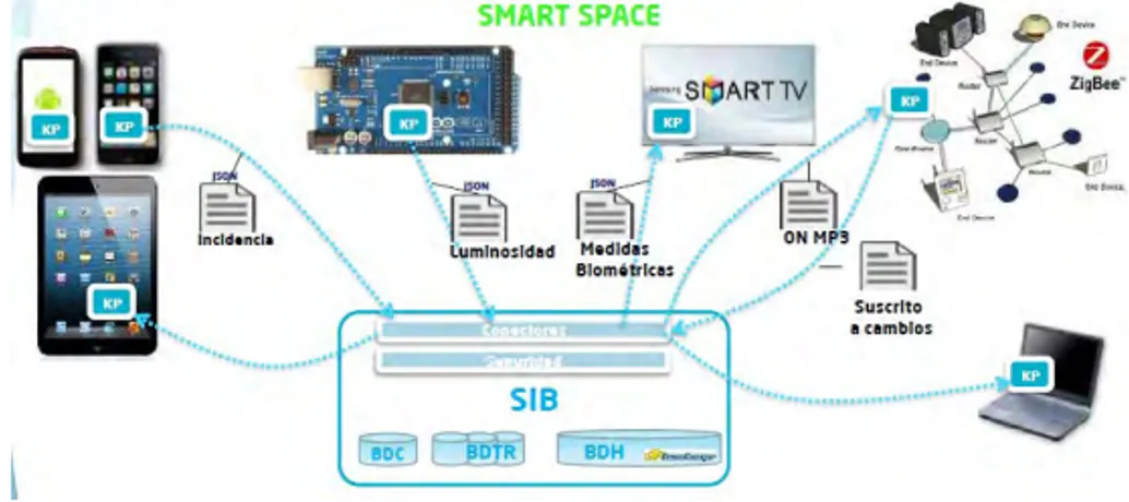
(7) ATICA2017: Tecnología. Accesibilidad. Educar en la sociedad red.. 2. Using de tool. SOFIA is a middleware that provides an interoperable semantic platform by intelligent internet of things, and builds composite services with an open source approach to realize multi-language and agnostic smart device communications. It is a semantic interoperability platform and its efficiency has been tested in seven pilot projects associated with varying contexts, including Smart Cities. After the project Sofia was completed, Indra company upgraded it into Sofia2 [11]. Sofia can be freely available in the scientific community, and can be fully installed with source code. Sofia2, an enterprise version, is defined as "Integration and collaboration platform without coupling between things (IoT)". Its architecture consists of four basic components: the Smart Space, the Knowledge Processor (KP), the Smart Space Access Protocol (SSAP) and Semantic Information Block (SIB SIBB). The Smart Space is the virtual environment where different applications offer functionality platform and there is a single SIB (that may be a cluster of SIBs) in each Smart Space. In specific cases, however, a Smart Space may have a federation of SIBs. The KP is a producer/consumer for information. KP is any user, device, application or system that produces or consumes any kind of information. The SSAP is the standard messaging language to communicate between the SIBs. This language is autonomous from the underlying network (GPRS, 3G, WIFI, Bluetooth, HFC, ZigBee). The SIB represents the core of Smart Space acting as an integrator of semantic information. It receives, processes and stores all the information of applications connected to the SOFIA Platform. A general scheme is shown in the graph of Fig.1.. Fig. 1. View of the components of ontology of SOFIA. The operations performed between SIB and respective KPs are as follows: The mechanisms of authentication, authorization and instantiation of the site (JOIN), the disconnection of a KP SIB (LEAVE), normal procedures insertion, updating and deleting information by the SIB (INSERT, DELETE, UPDATE) and all query operations (QUERY), a KP to subscribe to the running of a query every X seconds, or to an event triggered on the SIB. (SUSCRIBE), sending a result from the SIB to one or more KPs to solve a subscription (INDICATION), unsubscribing from a. - 799 -.
(8) ATICA2017: Tecnología. Accesibilidad. Educar en la sociedad red.. subscription made (UNSUBSCRIBE), requesting the settings associated with an instance by the KP (CONFIG). It is noteworthy that the platform has a strong semantic view that the information in all domains of intelligent area is standardized and connected through ontologies. The information of any agent can be available to the platform. Of course, it is designed to support storing large volumes of data in compliance with the rule of the four Vs (4V's) (Velocity, Volume, Variety and Veracity). The SSAP protocol is responsible for the communications between SIBs and KPs, therefore, the system can communicate with sensor networks, mobile devices and web browsers. In Sofia2 there are two methods to implement it. One is based on XML called SSAP-XML, and the other is JSON schemas, called SSAP-JSON. In each method there are three types of messages: REQUEST, which is the request sent from the KP to SIB, RESPONSE, which is to response to the messages of the above type, and INDICATION, a notification sent by the SIB to the KP on an event that the KP subscribed to.. 3. The information described in Ontologies. Ontologies are semantic descriptions of a set of classes. It can easily exchange information using specific instances of those common classes. SOFIA2 represents ontologies in JSON format. Using ontologies to describe knowledge in smart cities has been applied in SCRIBE (Smarter Cities Model Reusable Information and Business Events) [12], which is a semantic model for smart cities designed to collect data from various cities. As the authors said, this model is not closed and may undergo continual changes in the future. In this context the benefit of using ontologies in smart cities is twofold. Firstly, ontologies can facilitate the activity of information fusion [13] and integrate the data collected by different agents to build an intelligent territory. Secondly, ontologies can provide us a clear way to understand what is included from different information sources, such as different sensors. In Sofia2 ontologies are represented in JSON-Schema format, for example, the KP of a temperature illumination sensor could be represented as: "SensorIllumination":{ "coordínate Gps": {"altitud":0,"latitud":43.623374,"longitud":8.425680}, "identificator":"SIlluminacion_00123", "mesure":31, "timestamp":1373887443001, “unit”:”L”}}. These ontologies described in the platform make you to validate whether the semantic information sent by the KP meets the grammar rules defined in the ontology. JSON scheme satisfying the SensorIllumination ontology from the previous example is: {"$schema": "http://json-schema.org/draft-03/schema#", "title": "SensorIllumination Schema", "type": "object", "properties": { {"id": {"type": "object","$ref": "#/identification"}, "SensorIllumination": {"type": "string","$ref": "#/datos"}. - 800 -.
(9) ATICA2017: Tecnología. Accesibilidad. Educar en la sociedad red.. }. }, "identification": {“title”: “id”, “description”: ”Id incrusted of Illumination” "type": "object", “properties”: {"$oid": {"type": "string", "required": false}, } }, "datos": { "title": "datos", "description": "Info SensorIllumination", "type": "object", "properties": { "identification": { "type": "string", "required": true }, "timestamp": { "type": "integer", "minimum": 0, "required": true }, "measure": { "type": "number", "required": true }, "unity": { "type": "string", "required": true }, "coordinateGps": { "required": true, "$ref": "#/gps } }, "gps": { "title": "gps", "description": "Gps SensorIllumination", "type": "object", "properties": { "altitude": { "type": "number", "required": false }, "latitude": { "type": "number", "required": true }, "longitude": { "type": "number", "required": true } } }, “additionalItems”:”false”,. When an ontology is stored in the Real-Time Data Base, meta-information is added to the data base. We can see the information highlighted in the following example shown in previous paragraph.. - 801 -.
(10) ATICA2017: Tecnología. Accesibilidad. Educar en la sociedad red.. {. }. "id": {"$oid":"53e7abc445301ea8b0cf23423"}, "contextData":{ "session_key":"08bf50c8-6ea6-41dc-99ac-5d12a6f517a3", "userid":1, "kpid":9, "kpidentificador":"gatewaysensores", "timestamp":"1373887444356" }, "SensorIllumination":{ "coordínateGps":{ "altitude":0, "latitude":43.623374, "longitude":-8.425680 }, "identification":"S_Iluminacion_00123", "measure":19, "timestamp":1373887443001, "unity":"L". Various components are connected to the platform as KPs with no coupling. New applications will be compatible with earlier ones because they share the same data structures.. 4. Specifying the recommended data model. Described in the previous section when we can use the platform to construct our project, some resources and information services should be added transparently for improving the scalability. We propose the following data model in the definition of ontologies, JSON format is used as the template (currently following JSON Schema 0.4 http://json-schema.org/draft-04/schema#). Data type as follows: UUIDs: Text sgtring. Standard Universally Unique Identifier. Integer numbers 64 bits long integer. Example: {'counter' : 10} Float numbers: Simple notation. Decimal point. 64 bits Example: {'value' : 10.5} Text strings: Text strings. UTF-8. Special characters escaped. Example: {'comment' : 'next point'} URLs y URIs: Text strings. Coded following standard RFC-1738 Example: {'url' : 'http%3A%2F%2Fwww.coruna.es%2Fmedioambiente%2F'} Timestamps: Date. Text strings following ISO-8601 format. RFC 3339.. - 802 -.
(11) ATICA2017: Tecnología. Accesibilidad. Educar en la sociedad red.. Object containing attribute “$date” Example: {"timestamp":{"$date":"2017-01-27T11:14:00Z"}} Dates and date ranges: Text strings following ISO-8601 format. RFC 3339. Object containing attribute "$date" Date example: {"created":{"$date":"2017-01-27T11:14:00Z"}} Sample interval between dates: {“period”:{“$date”: 2T11:44:09Z/2010-07-02T11:47:00Z”}}. “2010-07-. Address: Notification simplified for ease integration. {address:{ }. “location”:”text string”, “number”:”text string” }. Unityes of measures: Text string following JScience library notation [15]. (http://jscience.org/api/javax/measure/unit/SI.html) (http://jscience.org/api/javax/measure/unit/NonSI.html) Example {'unit': 'A'} # Amps. Geographical Coordinates: Following the definition OGC GeoJson. Scheme WGS84 coordinates. No Z coordinate. Order [longitude, latitude] Points: GeoJson Point Example:. {geometry:{ “type”:”Point”, “coordinates”:[-8.6658883838376, 43.797987897899] } }. Lines: GeoJson LineString Example:. geometry:{ “type”:”LineString”, “coordinates”: [[-8.6658883838376,43.797987897899], [3.77979778878878,-7.8987987878988]] }. 5. Conclusions and future work. The data model proposed above can guarantee to manage all data from existing sensors in the market today, and new APIs in the selected platform are updated. - 803 -.
(12) ATICA2017: Tecnología. Accesibilidad. Educar en la sociedad red.. constantly. A set of ontologies deployed by the Sofia2 are sufficient to implement the SmartLand in Chinchipe. While the data models of the intelligent platform change, the ontologies must be changed accordingly. Therefore, matching techniques for ontologies can be used for solving the problem. On the other hand, we can manually adapt to the changes, for example, a supervisor can check the ontologies, inspect how they affect existing services and then update ontologies. These changes are possibly for a certain entity or a hierarchical structure in ontologies. Some deeper research can be done in the area.. References 1. Ordoñez, G.A.; Salud ambiental: conceptos y actividades. Pan American Journal of Public Health, Am J Public Health 7(3), 2000. SciELO Public Health. 2. Tapia, D.I.; Abraham, A.; Corchado, J.M.; Alonso, R.S. Agents and ambient intelligence: Case studies. J. Ambient Intell. Humaniz. Comput. 2010, 1, 85–93. 3. B Sterling, L Wild, P Lunenfeld; Shaping Things. Mediaworks Pamphlets. September 2005. 4. Abowd, G.D.; Dey, A.K.; Brown, P.J.; Davies, N.; Smith, M.; Steggles, P. Towards a Better Understanding of Context and Context-Awareness. In Proceedings of the 1st International Symposium on Handheld and Ubiquitous Computing, Karlsruhe, Germany, 27–29 September 1999; pp. 304–307. 5. Fazio, M.; Paone, M.; Puliafito, A.; Villari, M. Heterogeneous Sensors Become Homogeneous Things in Smart Cities. In Proceedings of the Sixth International Conference on Innovative Mobile and Internet Services in Ubiquitous Computing (IMIS), Palermo, Italy, 4–6 July 2012; pp. 775–780. 6. Chin, J.S.Y.; Callaghan, V.; Clarke, G.; Hagras, H.; Colley, M. End-User Programming in Pervasive Computing Environments. In Proceedings of the 2005 International Conference on Pervasive Systems and Computing (PSC), Las Vegas, NV, USA, 27–30 June 2005. 7. SmartLand; Gestión inteligente del terreno. Available online: http://smartland.utpl.edu.ec/ . 8. UTPL: Universidad Técnica Particular de Loja. Available online: http://www.utpl.edu.ec/ 9. Otero-Cerdeira, L., Rodríguez-Martínez, F.J. and Gómez-Rodríguez, A.; Definition of an Ontology Matching Algorithm for Context Integration in Smart Cities. Sensors 2014, 4. 10. SOFIA:http://www.indracompany.com/sostenibilidad-e-innovacion/proyectosinnovacion/sofia-objetos-inteligentes-para-aplicaciones-inteli (accessed on April, 2017). 11. SOFIA2. Available online: http://scfront.cloudapp.net/ (accessed on April, 2015). 12. Uceda-Sosa, R.; Srivastava, B.; Schloss, R.J. Building a Highly Consumable Semantic Model for Smarter Cities. In Proceedings of the AI for an Intelligent Planet (AIIP), Barcelona, Spain, 18 July 2011; pp. 3:1–3:8. 13. Nowak, C. On Ontologies for High-Level Information Fusion. In Proceedings of the Sixth International Conference of Information Fusion, Queensland, Australia, 8–11 July 2003; Volume 1, pp. 657–664. 14. Conceptos Sofia2. Available online: http://sofia2.com/docs/SOFIA2Conceptos%20SOFIA2.pdf (accessed on February, 2015). 15. JScience library notation. Available online: http://jscience.org/api/javax/measure/unit/SI.html (accessed on Febraury, 2017).. - 804 -.
(13)
Figure
Documento similar
In the context of smart cities, dimensionality reduction of data stream or stream transformations obtained through shifted (overlapping) windows can results in a data rate,
For the assessment of the direct damages to properties three different types of data were required: Flood maps (hazard), types of properties across the municipality (detailed
It is generally believed the recitation of the seven or the ten reciters of the first, second and third century of Islam are valid and the Muslims are allowed to adopt either of
Reflect and imagine that in the same way computers receive data through the different input devices, you receive information through your senses; after that,
Different quantities were compared between data and Monte Carlo to test the validity of the Monte Carlo description of the data for events with large E / after the pre-selection cuts
For this reason, firstly, the different processing tasks involved in the automatic people detection in video sequences have been defined, then a proper classification of the state
Therefore, the developed cryptoprocessor allows securing heterogeneous local Wireless Sensor Networks composed of IoT devices, independently of the protocols used in
Different aspects of data transmission and propagation times required for sending a case specification and the associated microservices for the composition of the monitoring system,
