Application of research findings in earthquake disaster : Preparedness planning and management International Research and Training Seminar on Regional Development Planning for Disaster Prevention (1987 Oct 13 23:Tokyo)
26
0
0
Texto completo
(2) NOTE Opinions expressed in signed papers are those of the author(s) and do not necessarily reflect those of the Secretariat of the United Nations, the United Nations Centre for Regional Development, or of the organiza tions concerned with the International Seminar. The designations employed and presentation of material in this publica·· tion do not imply the expression of any opinion whatsoever on the part of the Secretariat of the United Nations, United Nations Centre for Regional Development, or of the organizations concerned with the Inter nationdl Semlnar, concerning the legal status of any country or territo ry, city or area or of its authorities, or concerning the delimitation of its frontiers, No part of this publication may be reproduced in any form or by any means without permission in writing from the United Nations Centre for Regional Development..
(3) APPLICATION OF RESEARCH FINDINGS IN EARTHQUAKE DISASTER PREPAREDNESS PLANNING ANO MANAGEMENT 1. Dr. A.S. Arya , Prof. L.S. Srivastava 2 INTRODUCTION There is no region in the world where earthquake problem can be comp letely neglected. But differness are recognised both in the intens1ty of ground shaking as well the frequency with which earthquakes recur in different areas of the world. Commonly speaking, earthquakes are included in the list of 'natural disasters' alongw1th cyclones, floods, drought, landslides etc. Studies on the 'causes' and 'effects' of the so called natural disasters have led to the mcreasmg awareness that they are in fact natural events which are converted mto disasters due mainly to the acts of man either through ignorance or neglect. The report "Prevention Better Than Cure" of Swedish Red Cross, 1984, rightly states that "The term natural disaster is misleadmg". The ground motion during earthquakes is rarely directly responsible to cause deaths or injuries to people. It is the collapse of unsatisfactory constructions which leads to disaster. Besides the · forces of nature released during these natural events, such as earthquakes, the majar factors leading to disastrous consequences are poor land use, the structural weaknesses in the handiworks of man such as houses, buildings, brid ges, lifelines etc., and neglect about the secondary chains of disastrous events which can result due to the failure of a major structure like a dam, a chemical or industrial plant or an A tomic Power Station. Fire can resul t due to short circuiting of electric wires, rupture of gas pipes or falling objects getting burned in kitchen fires due to earthquake shakmg. In the developing countries the d1sastrous effects are further pronounced by lack of. awareness and education, concentration of population m seism1cally very weak houses, lack of communica tion and transportation facilities, def1cient financial resources, etc. In fact, the poorer the population, the more vulnerable 1t is to the natural disasters. Hence the earthquake disaster mitigative measures must be the most economical and cost effective so that they could be afforded and accepted. This calls for research not only in sc1entific and technological aspects of the earthquake problem which may be more of global nature but also m socio-economic and management situations which are usua!Jy of local character. l . Professor and Head, Deptt. of Earthquake Engg. University of Roorkee, Roorkee, U.P. India. 247667. 2. Professor, Deptt. of Earthquake Engg. University of Roorkee, Roorke, U.P,. -1-.
(4) 'Hazard mitigation' usually means taking those actions befare an event which will m1n1mise the 1mpact of that event on the soe1ety. The losses to the society will be in the form of loss of lives, Joss of property, loss of produc tion, reduction in income of the people and their assets, increase in liabilities and expenses, etc. For an earthquake, mitigation would mean, such act1ons that would protect the existrng structures, !1felines, etc., and build new ones in such a way that they should suffer llttle darnage and remarn functional durrng ' the earthquake. This ideal is, however, far too h1gh to achieve due to serious constraints in rnost countries as statecl abovc. Hence 'preparedness' for a11t1c1pated effects and after-effects of the hazard becomes one of the strateg1es for reducing the impact on the affected community. Here also a number of questions have to be answered: where and for whom to prepare, what to prepare, best way to prepare, and so on ? Sorne time, because d1fferent types of professional and management persons are involved in mitigation and preparedness phases, the two rneasures are artificia!Jy separated by drawing a sharp line. This is detrimental to the cause of ·the society wh1ch both the rneasures rntend to serve, since as stated earlier, Prevention is Better Than Cure. Therefore the preparedness measures must include guidelines for 1mplementation of m1tigation measures by the people themselves as weJJ as sorne mrn1mum measures as part of Preparedness for it to become effective in reducing the misery of the affected people. Research has helped in answering the questions related to effective mitigat,on and prepa redness measures at minimum cost. PREPAREDNESS ACTIVITY Preparedness phase 1s directly related w1th the anticipated emergency situation that may arise just after the earthquake which wiJJ include the foJlo wing: n;iaintenance of law and order, preventing loot and theft; evacuation of people; recovery of dead bodies and their disposal by 1:;remation c:,f buríal; -2-.
(5) medica! care for the injured; supply of food and water and restoration of water supply 1ines; providing temporary shelters; restormg Unes of communication :and information, controlling rumours; restoring transport routes; quick assessment of damage and demarcation of damage areas accordmg to grades of damage; cordoning off severely damaged structures Hable to coilapse during after shocks; temporary shoring of precariously standing buildings to avoid coilapse and damage to adjoining buildmgs; and immed1ate action to prevent certain cham reactions which could develop during a severe earthquake e.g. controlled release of water from the reservoir of a dam wh1ch may get damaged and found ·dangerous, control on 1eaking toxic gases, treatment of environment to prevent spread of disease, etc. Opportunity should be utilized to learn lessons from the event for the future benefits by damage survey in a scientific manner, collecting instrumental and other field data from the effects of the earthquake like after-shock records, effects on well and spring water, changes of levels and distances, rockfalls and slips, fault ruptures, etc. It is useful to mention that much of present scienti fic learning about earthquakes owes 1t to the keen observations made by profes sionals as well as the public on what happened during the damaging earthquakes. There has always been something new to learn from each such happening. As a result of such observations through the ages, human ingenuity deveioped, based on locally available materials, such construct1on techniques which made the buildings adequately earthquake resistant. Examples can be cited of braced and brick-nogged wood frames in Jam TlU and Kashmir, Dhajji wall construction in Himachal Pradesh and Assam type Ikra construction in north-eastern regwn of India. Even sun-dried brick, adobe and rarnmed earth constructions had been so well strengthened by use of buttresses and wood elements m H1machal Pra desh in India and regions m Yemen Arab Republ1c that they have !asted for centuries under s eism1c environment. These techniques with further improve ments brought about by modern research efforts(l) can effectively be used. -3-.
(6) to build safe small tenements in the rural and semi urban areas in various se1s. mic intensity zones. COMPONENTS OF OISASTER PREPAREONESS. For cost effect1ve preparedness against a natural hazard the followmg are visualised as the important components of preparedness: i) Seismic Zoning and Microzoning of the country or the regían 1s essen tia1 so that the need and 1evel of se1smic safety required can be establ1shed. Basically for seismic zoning, data wiJJ be needed an earthquake occurrences and the geologic framework and tectonic set up of the region. For m1crozoning, addit10nal data on topography, local geological and soil conditions, Jevel of w�ter table, strong ground motion records etc., are required. Study of precursory phenomena helps in predicting an impending earthquake in terms of probable loc ation, magnitude and time of occurrence. Whereas seismic zoning wiJJ help in establishing long term needs of mitigation and preparedness in various zones in a graded manner, micro-zoning and prediction will indicate where more concentrated and urgent preparedness is necessary. ii) Soc1etaJ data in the identified se1smic regions is necessary in terms. of population density, prevalent building types, presence of vulnerable structures, and Jife-lines, socio-economic cond1tions, etc., so as to determine not only the vulnerability of the man-made structures under the probable earthquake but also the capability of the cornmunity to respond and absorb the eff ects of the shock. This will also help in fixing the targets of protection in a priority -w1se manner for cost effectiveness of the resource inputs. iii) The data from the above steps can be combined to carryout vulnera bility studies of the regions, subreg1ons or urban conglomerates. These will greatly help in planning and management of the. IT' higation. and preparedness. act1vities according to the realistic needs and not in a haphazard manner. It should also provide the basic inputs to the promulgation of governmental decrees and municipal bylaws and guidelines for land-use planning of settlements, spec1al construction features, ratrng of existing buildings for earthquake resistance and protective requ1rements, etc.. -4-.
(7) RESEARCH FINDINGS Study of seismological observations, strong ground motion records and eff ects of earthquakes on ground and structures has provided insight regarding earthquake sources, spacial and temporal variation of earthquake occurrence in such sources, severity and variation of ground motion at various distances from such a source during earthquakes, behav1our of ground, performance of man-made structures and facilities located on different soil and rock condit1ons in different situations of geomorphology and hydrology at various distances from the earthquake source; and other natural phenomena such as surface faul ting, regional uplifts and subsidences, f1res, and inundations from tsunami and floods resulting from failure of valley fills from landsllde and a valanch debr1s, embankments. and. Jevees during earthquakes.. The research findings related. to components of disaster mitigation and preparedness are briefly summarised in the following paragraphs.. EARTHQUAKESOURCE Majar earthquakes which result 1n damage on the ground occur due to ruptures and fractures in the lithosphere (say withm 70 km depth below ground) in regions where crustal deformations are actively taking place m the present tectonic regime and ev1dences of Neotectonism are observed. Boundar1es of llthospheric plates, m1d-ocean1c r1dges, the circum-Pacific 1sland ares and sub duct1on zone, and Alpine - Himalayan mobile belt constitute the majar earth quake belts on a global scale. Boundary of crustal blocks on a regional scale, and areas lying within the lithospheric plates show reduced arder in terms of size (magnitude as well as intensity) and frequency of earthquake occurrence. Great earthquakes (say magnitude M 1, 7.8) occur along and clase to the l1thosphe ric boundaries an::f other majar seismotectonic belts. Identification and demarca tion of seismotectonic features and characterising the activity as 'line-source' or 'planar source' along their various segme nts will provide the basic information on location of probable earthquake sources m future for evaluatio:i of earthquake hazards. Use of geologic data prov1de a long term assessment of potential of earthquake occurrence in future and defines the character of earthquake sources,. as in many s1tuations data ch;1racterismg contemporary earthquake. occurrence may appear to be unrelated with known or mferred capable faults.. -5-.
(8) A region with similar earthquake hazard at all places is defined as 'seismotectonic province'. Earthquake occurrence unrelated with seismotectonic structure, that is, the capable faults and other active tectonic lineaments, are classified as 'floating sources' in a seismotectonic province. Remote sensing can be usefully employed in demarcation of active tectonic lineaments in a region wherein evidences of Neotectonism and Recent movements have been observed on the ground. EARTHQUAKE SIZE The amplitude of seismic waves (e.g. body waves and surface waves, recorded at a place), the parameters of the earthquake source (viz., stress drop and seismic moment), and the area affected by shaking felt by people, indicate the size of rupture zone at the earthquake source. The size of earthquake referred as Richter's magnitude is computed from near field ground motion records. Body wave, surface wave and moment magnitudes are also utilised to indicate size of earthquake. Magnitude is expressed by Indo-Arabic numerals such as 7.8. The longer is the length of fault rupture at the earthquake source the higher will be the magnitude. Though originally defined as an open ended parameter, the magnitudes determined from recorded amplitudes of seismic waves of various periods of vibration show saturation indicative of an upper limiting value, probably controlled by deformation and rupture strength of the lithospheric rocks. Earthquakes of larger size beyond such a limiting value may indeed result in longer duration of rnotion due to larger size of the earthquake source. Higher the magnitude of the earthquake, longer will be the duration of strong ground motion and larger will be area affected by the earthquake. The rating of the effects of an earthquake at a place or an area is done in terms of Intensity scale, the more common ones now are Modified Mercalli Intensity scale and the MKS Intensity scale. STRONG GROUND MOTION Free field strong ground motion depends on the mechanism and size of rupture at the earthquake source, seismic wave attenuation characteristics of the interveníng medium from the source to the place of observation and. -6-.
(9) the local inf luences of topography, depth of soil and other deposits overlyrng base rock, and ground water conditíons. Soíl - foundauon - structure ínteract1on effects rnf Ju,�n.-::e the recorded ground motion dose to and at the fodndat10n level of structures. Strong ground mot1on _in earthquakes w1th Richter's magni. tude ·�. j. is restricted within a small area and has relatively. short.·· duration. hence in gen,eral has little damage potentíal. The severity of motíon increases with higher magnitudes. In the m:1gnitude range 5 to 7, it attains a high value clase to the earthquake source and attenuates away from the source with dist ance. But the severity clase to the earthquake sou1-ce does not show a significant increase for earthquakes with magnitude greater than 7 although the area .:1ffec ted goes on increasing. The extensi ve damage dudng such earthquakes affecting large areas is the result of longer rupture length and duration of strong ground rnotion. The time history of strong ground motion around an earthquake source is characterised by the rupture mechanism and size of rupture that is the earth quake magnitude. More or less similar motion occurs on the two sides of the rupture in a 'strike slip' mechanisrn. Significant dífferences in the ground motion are observed in the hanging and footwall sides in 1 d1p-slip: and 'thrust' mecha nisms. lsolated peaks of small duration, larger than the effect1ve average ampli tude of strong ground motion result from rebound in thrust mechanism or high stress drop in ruptures of s1gnificant asperities along the failure surface. Surface shear waves and Rayle1gh waves constitute the bulk of the strong ground motion which adversely affect the stability of the ground and the man-made structures, and the severíty is seen to reduce w1th depth. At an approximate depth of 30 m or more, the severity reduces to half of that at the ground leve!. The long period surface waves attenua.te with distance less rapidly than the short period body and Rayleigh waves. This understanding regarding nature and severity of strong ground motion is a significant advancement in the engineenng applica tions for safe design of various structures and systems. EAR THQUAKE HAZARD Earthquake hazard at a place or an area, within a given time interval, expresses the probability of occurrence of a visible adverse effect such as damage to buildings and structures, ground failures (fissures, landslides, avalan-7-.
(10) ches,. lurchmg,. dífferentíal. settlements,. líquefaction,. etc.),. surface. faultíng,. uplifts and subsidences, inundation and tires. The severity and durat10n of strong ground motion g overn the damage potential based on the dynamic characteristics of the buildings and structures, earth slopes :tnd dams, etc. DispJacements aJong the rupture surface at the earthquake source spreading upwards towards the ground cause surface faulting, uplifts and subsídence, and íf such ruptures cut a cross structures, very severe damage can take place. lt will not be feasibJe to restraín dísplacements along active taults. Therefore seísmícally active faults extendíng to the ground surface should be avoided while locating structures. But avoiding may not always be possible, as in case of long tunnels and other lifeline structures. In such casses measures should be adopted in des1gn for localisíng and minimismg damage without loss of function and load carryíng capacity.. Alternat1vely,. adequate flexibil1ty to. absorb. the dísplacement. (or. self healing material as in earth and rock f1ll dams) should be adopted. Tsunamíes are generated by exc1tat10n of Jarge water masses of oceans by majar earthquakes often resulting in inundation of coastaJ areas, and as their deveJopment can not be prevented, construction at appropriate elevatíons in coastal regions and network of observation and warning system are the rnain mítigation measures for safety against such sea waves.. Floods could be caused due to failure of dams retainmg large reservoirs. Rupture of electrícaJ wiring, gas pípelines and contramers of inflammable líquids and gases can Jead to fires, whích under certaín condition can develop in confla grations.. GROUND F AILURES Slopes. with. critícal. stabílity. can. undergo. irreversible. displacements. when subjected to strong ground motion, resulting in Jandslides and slips. Stress waves impinging on ground surface m mountainous terrain result m scabbmg of rocks on steep slopes and hiJI tops, and sliding and over turnmg of rock fragments and boulders initiate movements of surf1c1al material cascadmg down wards. forming surface runs, debris fall and avalanches, carrymg with them. buddmgs, roads and other structures down to the valley base. Local sl1des and rock fall in such terrain block transportation routes and retammg and breast -8-.
(11) walls on roadsides are damaged. Rock mass volurnes, when excited through interaction with predominent periods of ground vibrations in the epicentral tract, will develop fissures and dislocations along the weaker planes and zones. Unconsolidated strata in river valleys and alluvial plains, on similar excitation, produce fissures, mole tracks and lurching, that is, sliding and overturning of soil blocks converting an alluvial plain finto a hammocky ground. Dynamic pore water pressure is caused due to seismic vibration in saturated loose cohesionless soils in alluvial plains and coastal regions and similar loose cohesionless material inter-bedded with cohesive material which results in loss of shear strength of the soil and with significant duration of strong ground motion, causes its liquefaction. The liquefied soil flows in underground openings, and where the fluid pressure exceeds the overburden loads, the liquefied soil ejects out on the surface, rupturing through fractures and fissures in the soils cover aboye ground water table, forming sand fountains and flows on the surface. Craters of sand fountains and layers of sand flowing from fissures cover the ground resulting in soil polution. Settlernent of soil takes places in the process, which in the coastal regions of ten results in inundation by water from the sea. Buildíngs, structures and objects located on liquefied soil undergo subsidence and tilting, and under-ground pipelines, septic and storage tanks and other structures suf ler ruptures, distorsions and uplift. Ground breaks resulting from displacements along the rupture surface follow well defined tectonic lineaments. The trend length of area covered by fractures, and the horizontal and vertical offsets on the two sides of such ground breaks provide data for confirmation of earthquake source mechanism and fault plane solutions obtained from analysis of seismological records. However such ruptures should be discriminated from fissures resulting from ground failures.. Researches in soil dynamics and rock dynamics have brought out significant results regarding the aboye phenomena and the properties of soils and rocks affecting the obser ved behaviour in relatíon to the intensity and frequency contents in strong ground motion. Thus potential land slide areas can be mapped and analysed and the liquefaction potential of soil deposits can be worked out by laboratory testing and analysis. IVIethods have also been developed for improvement of site conditions for preventing land slides and slope failures and appropriate compaction of soils to avoid their liquefaction. -9-.
(12) BEHAVIOUR OF MAN-MADE STRUCTURES. The behaviour of buildings and structures is controlled by their strength, the dynamic characteristics, interaction with the predominant periods of ground motion and the behaviour of the soil on which they stand. The greatest deformation and stresses which the structures standing aboye ground undergo are governed by the dynamic amplification of ground motion over the range of their structural frequencies and the inherent darnping. Underground structures surrounded by soil or rock mass follow closely the displacement of the ground. Darnage and failure of structures during an earthquake result from development of strain beyond yield, excessive displacements and rotations along joints and supports and development of plastic deformations and hinges in the structural framework. Failure and falling of non-structural elements in buildings such as glass panes, false ceilings, ornamentations, clading and partition walls, etc, cause injuries to people and account for very large portion of the economic losses. The degree of earthquake resistance that the different structures should have, depends on their importance and permissible damage, which is to be based on their desired performance during the maximum credible earthquake. Various levels of earthquake force can be specified for different structures for design within working stresses utilising ductility and energy absorption capacity of the structures so as to have adequate safety to remain functional after the earthquake. Well designed and appropriately constructed structures are less susceptible to damage than poorly designed and deteriorated structures. Earthquake resistant design and construction methods of different types of residential and industrial buildings attempt to optimize the cost-benefit ratio and at the same time avert the collapse of structure and loss of life, taking into consideration available construction materials and quality of construction as limited by the economic resources of the individuals and the country. Community buildings such as schools, cinema halls, thedtres, multistoreyed ()Ince and commercial complexes, and other structures for large gatherings and occupation of people, service buildings including hospitals, police and fire stations, telephone exchanges, radio and television stations, etc. and lifeline structures, that is structures for electricity, water supply, and transportation systems demand higher earthquake resistance in relation to ordinary residential buildings to reduce largér loss of life, provide rescue and relief to the affected people and prevent díslocation of essential supplies and services for the people. If dams impounding large. - 10-.
(13) quantities of water, water and gas pipelines, structures for transport routes like bridges and tunnels, structures for storage of infla mmable or poisonous fluids and explosive materials, and nuclear reactors and facilities suffer serious damage or failure during earthquake, they will accentuate the disaster. Such structure require detailed and judicious study for evaluation of earthquake hazards, analysis and design to have safe or fail-safe construction. Research has led to methods and techniques of analysis and design to achieve the desired safety levels of various types of structures for stipulated earthquake ground motions and resulting forces. HUMAN RESPONSE In general there is lack of awareness in most communities about earthquake hazards and mitigation rneasures to reduce earthquake risks. The earthquake events are considered by the common people as insurmountable natural phenomena, as fated events or an act of God or gods. The fact that earthquakes, can neither be prevented nor reliably predicted, has inhibited to develop a safety consciousness against earthquake hazards in the society, specially in developing and under-developed countries. Due to ignorance about mitigation and preparedness measures, any forecast or prediction for an earthquake results in fear and panic in the people leading to social problems and turmoil in the region. On the other hand, in the prevailing socio-economic conditions in most cases, individual owners prefer not to have earthquake resistance incorporated in the construction of their own buildings, as in their belief the chances of the dwelling being destroyed by earthquake during their own lifetime is not large. The individual is also not motivated to adopt earthquake resistant provisions as his neighbours have not done so nor do the local authorities so specif y. Such provisions are also not made even in many public buildings for want of suitable bye-laws or guidelines. Information on good construction practices, reduction of earthquake damage where such practices have been adopted, vulnerability of existing structures, seismically safe construction methods on hazardous ground conditions etc. needs to be disseminated to the people in severe seismic regions so that a safety culture is developed..
(14) APPLICA TIONS OF RESEARCH FINDINGS Where As stated earlier, the first question to be answered is which are the regions, areas, or locations in a country where mitigation and preparedness measures should be taken in order of priority ? Earthquake occurrences in the past, systematícaUy catalogued for as long a historica1 period as feasible provide , the first indicators. PaleoseismicJty research helps in extending the evidence backwords in history. But in view of the Jimitations of such records, a good statistical average frequency or return periods of particular magnitudes of earthquakes is not reliable.. Hence this information is further supplemented. with identification of probable earthquake sources, that is, active or causati ve faults and use computationaJ algorithms fo arrive at probable. future seismic. activity. Another area of research is establishment of attenuation 1aws which will reliably determine peak ground accelerations ín the region of interest. Results show that local geological, topographical and soil conditions play crucial role and make them regíon/locatíon specific. Based on the research studies as stated here above, the earthquake hazard can be evaluated with adequate confídence and seísmic zoning with respect to expected lntensities on MM/MSK scales, and peak ground acceleratíons with corresponding probable return periods can be developed. For specific loca tions of certain major projects and critica! facilities or urban conglometrates situated ín these zones, detailed mícrozonation can be worked out. For whom The second question is. 'for whom is the dísaster preparedness requi. red ?" The answer is provided by seismic risk evaluation. The seismic risk is a function of the earthquake hazard in the tectonic province, the locat1on of the place relative to the earthquake source, the vulnerability of the construc tions at the place and the prevailing socio-econornic conditions. Larger the hazard, nearer the source, weaker the constructíons and poorer the popula tion, larger wi11 be the seismic risk to Hfe, limb and 1ive1ihood. Based on the relevant seismic and socíetaJ data and the available resuJts of researches regar-. -12-.
(15) ding levels of earthquake resistance and vulnerability of man-made structures and systems, appropriate seismic risk models can be developed which w1l1 dif fe rentiate between the high risk to low risk locations, structures and system, thus bringing out not only the needs of mitigation and/or preparedness measures but also the order of priorities in such actions. Needless to mention that vulnera bility of natural slopes to slides and slips, that of soils deposits to partía! or total liquefaction must be inc!uded in the vulnerabi!ity and risk analysis. It must be realized that it is almost impossible to rmtigate against all impacts of earthquake on the society. Hence not only the poorer communities but even those which are economicaHy better off need to be selective in choo sing the targets for protection. There seems to be a consensus now on the fo!lowing priority list: i) Hazardous Structures Those structures whose failure can lead to extensi ve loss of life and property to population at large, such as dams posing danger to areas downstream of the reservoir, nuclear power plants posing radiation hazard, containers of toxic gases, and the 1ike, wi11 require safety under the max1mum credible earth quake which is 1ike1y to impinge on them. New ones must now be adequately designed and existing ones need to be strengthened where required. Preparedness should inc!ude these protective actions besides other actions like f!ood zoning of the downstream of vulnerable dams and areas surrounding the other hazardous structures, and warning and evacuation of populations 1ike1y to be affected in good time. ii) Lifeline Resources These would inc!ude essential services (water, power, sanitation, telep hones and telegraphs), aH emergency medica! services, police and revenue offi ces, planning off ices deaJing with the disaster, etc, and transportation links viz., railway, important link roads and airports. iii) Key Economic Activities. -13-.
(16) This refers to those industries or markets which if destroyed during an earthquake will result in great economic hardship to population due to loss of meaos of livelihood over a considerable length of time. iv) Places of Public Assembly These should naturally take precedence over individual houses in view of possible concentrated loss of Hfe (as it happened due to the collapse of a mosque and madrassa in the earthquake of Dec. 1982 in Yemen Arab Republic) and wiH include schools as the first choice, cinemas, places of worship, commu nity halls, etc. They are important since they also serve the emergency purpose of providing shelters to the people in distress after the disaster. v) Cultural Monuments Those buildings or structures to which the communities attach a high value need to be protected by prior action. vi) Individuals Whereas the above five categories wil1 usually require action by public authorities, the individuals have usually to fend for themselves.. Awareness. and educationa1 programs through mass media and extension services will help create the culture of self-help and cooperative action for mitigation as well as preparedness, and their involvement in preparedness for emergency action wi11 be the most crucial factor in the implementation and success of the plan. Nature and Extent of Preparedness The next question relates to the nature and extent of preparedness. These will naturally depend on the scenario that emerges from the seismic risk studies and the resources available in terms of funds, man power, technolo gical knowhow and sk1Jls, relative importance of disaster mitigation with respect to other social-economic needs of the people, the awareness of the risk, and the political will to plan and implement the mitigation and preparedness measu res. If one looks at the situation in rnost seismic countries and regions of the world, it will be found varying from no preparedness at aU as in most developing. -14-.
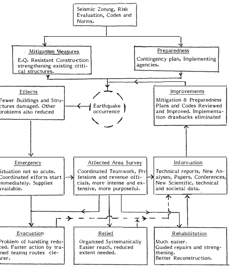
(17) countries to very high Level of mitigation activities as part of preparedness for receiving a m agnitude 8.0 earthquake as in Japan, where effective measures have been conceived and implemented against spread of fire as well as tsunami inundation. These states of affairs can be visualised as shown in Figs. 1,2 & 3. Figure 1 shows the general situation after a damaging earthquake occurrence where no preparedness existed. There will be many differences in details in various countries. But in general the situation becomes rather chaotic, the response of the people is random-mostly of despair and rarely of hope, mostly negative and seldom positive. Rumours abound and criticism of the administration builds up into a cry even as evacuation, relief and rehabilitation proceed through the Government and voluntary agencies. Then as time passes, and the aftershocks die down, life limps back to normal, the earthquake event is forgotten, the disastrous act of nature or the gods is over. All remains peaceful until the next one comes after a few decades or a century, and history repeats itself. Figure 2 shows a more enlightened situation where the lessons learnt in the earlier events created enough recognition of the problem resulting into actions regarding seismic zoning and preparedness for the emergency situation. Here the various activities become systematic, actions become swift and coordinated, the population feels involved resulting in a positive attitude and mutually cooperative, voluntary agencies perform tasks as visualised and assigned, and wastage of precious resources is minimised. Also valuable information of scientific, engineering and socio-economic interests is generated by professional teams for future planning and implementation. Figure 3 presents a mix of disaster mitigation and preparedness measures taken for implernentation in the earthquake prone area likely to get the next damaging event. Due to effective mitigation measures undertaken, the disastrous impact of the earthquake is very much reduced hence all emergency operations should become easier leading to the community life fast returning to normal. The results of research which are already, available as stated earlier in the paper find obvious applications in the different activities brought out in these figures. Hence knowledgable institutions and sceintific and professional -15-.
(18) personnel should be fully involved in planning and implementation of the mitiga tion and preparedness measures should not be 1eft to the generalist administra tors and revenue officials alone. A TYPICAL OUTLINE OF PREPAREDNESS MANAGEMENT As stated earlier earthquakes cause havoc, as they occur without any warning and create widespread damage in a very short time. As a consequence people panic, which aggravates the situation. It is therefore nec�ssary to evolve well thought out measures in a planned manner, so that the local population becomes alive to the problem and is prepared to meet the hazard with coo1 courage, discipline and determina tion. The object of the contingency plan should be to organize disaster relief measures covering both the urban and rural affected areas. A 4-tier preparedness management setup needs to be worked out at the following levels: i) ViUage Counci1 It is the lowest functional unit. Each village counci1 should have an Advisory Committee to coordinate and implernent different functions. ii) Sub-Divisional Unit This has its nucleus in the subdivisional headquarters to help, coordinate and implernent the programs undertaken by the vi11age councils and also look after the work in affected sub-division towns. It could have sub-units at Block levels where area to be covered is large as in India. iii) District or Province level unit This is the highest unit in a State or Province and is required to keep a clase liaison with the Central Governrnent. Th1s unit will help review and coordinate the activites of the lower formations in the state and also formu late and disserninate the policy dicisions. Action is required to be taken on the following at three different stages: -16-.
(19) i) Before Disaster Enrollment of volunteers and their training, assessment of magnitude of problem likely to arise, demarcation of responsibilities of official and non-official agencies, resources evaluation-manpower, equipment, transport, shelter, hospitals etc. ii) During Disaster Visit to place of occurrence, ascertaining damages, prompt operational decisions, report to higher authorities, assessment needs, arrangement of proper services to victims. iii) Af ter the Disaster Procurement of transport, setting up of centres for information, shelter, field hospitals, restoration of essential services-equipment and stores, repair/replacement of damaged equipment, returning of materials procured on loan and release of volunteers. Coordination and control of the work to be carried out by the various services during a calamity is essential and hence the measures undertaken could be grouped under the following heads of services: Relief Operations: i) Technical services Fire fighting, rescue of casualties, salvage of property, debris clearance, emergency demolition and repairs, restoration of essential services, maintenance of law and arder. ii) Medical and Health Services First aid parties, first aid posts, innoculation and vaccination veterinary -17-.
(20) services. iii) Welfare Evaluation,. emergency. feeding,. sheltering and clothing,. information. centres, publicity, psychological first aid, and prevention of panic. Head Quarters Services. The Administrative officer in the area will act as Ex-officio Assistant Controller, Civil Defence in his Block area and shall be located at Block head quaters and the same will be used as the Disaster Relief Control Centre for the Block. Communication Service. All available means of Communication Services besides telephones, such as Police wireless/runners/trained messengers, etc., shall be used in the Disaster Relief Control Centres. Warden Service. During disaster, the services of persons of influence, media-coverage and personality with sound knowledge of the locality will be necessary to advise and help the affected people, and to serve as a link between the public and the authorities To provide this, the Warden's service is organized, whose duties shall be to enlist volunteers and relief parties, to assess damage and report to the control centre, assist and guide relief services, prevent and control panic and counteract rumours, render shelter to homeless people, arrange tempo rary pyres or morgues, inform people. Veterinary Service. The extension officer (vcterinary) will be in charge of this service in the concerned block who will assess the requirement of veterinary services to be undertaken in the affected areas. During and after disaster, the following -18-.
(21) are required: Alerting of subordinate and field staff, arrangement of personnel, stores, equipment and vehicles and the program of relief work. Assistance to public in taking preventive measures against any epidemic among livestock, vaccination, distribution of feed and fodder, taking steps for repair of damaged veterinary buildings and restoration of equipment and stores, etc. Rescue Service The primary object of the rescue services will be the rescue of the living p ersons entrapped in the debris, and recovery of the dead bodies at a slightly later stage. The junior engineer possessing a sound technical knowledge will be in charge of the rescue service in a Block and his duties will include: enrollment, training and demonstration of the services and maintenance of records. Preferably, personnel for rescue work should be from Home Guards, and they should be trained in first aid. Medium and heavy rescue work will be done by the Public Works Department and Assistance from Army units and other security forces may be taken. Welfare Service In the event of a severe disaster, many become homeless, and a large population need food and clothing. The problems resulting from death, injury, loss of home, etc., would be handled by the welfare service. The victirns will have to be supplied with essential items immediately, but should also be encouraged in self-help. The availability of such facilities can play a decisive role in not only raising public morale, but also in rehabilitating the population. The functions of the welfare service in general, are supply of information, tare for homeless and evacuation. The plan broadly indicates different services with organizations responsible for implementing it in the field. These services will be organized by the different Departments in a coordinated manner at the District as follows: 1.. Casuality Service (Health and Family Welfare Department). 2.. Comunication Services (State Police/Radio Organization). 3.. Fire Fighting Service (Fire Service Organization) -19-.
(22) 4.. Welfare Service (Education & Social Welfare Dept./ Public. Works. Dept./. Public Health Engineer) 5.. Wardens Service/Local Leaders Service (Local Administration). 6.. Corpse Dísposal Service (Local Administration). 7,. Veterinary Services (Animal Husbandry & Veterinary Dept.). 8.. Rescue Service/Medium Rescue/Flood Relief Service / Salvation Army/ Home Guards Organization/Public Works Dept.). 9,. Salvage Service (same as number 8). l O.. Training Service (same as number 8),. 11.. Supply Service (same as number 8). 12.. Depot and Transport Service (Community Development Dept.) The breakdown of the financia! requirements in the matter of organizing. the services on the basis of the overall contingency plan will depend on the earthquake affected area of the State and prevaili11g-cost structure, and must be worked out in each case after the seismic risk studies. It may also be men tioned that much local level research will be needed to make the services truly effective. Sorne of the research areas can be mentioned ,. e.g., ascertaining �amages, shelters, disaster medicim, and corpse disposal, rescue oper�tions, fire f ighting etc. CONCLUSIONS. In order to be able to take appropriate preparedness measures for meeting the emergency situation created by a damaging earthquake effectively, there are no short cuts to the sustained research ef forts which must be made to identify and delinea te the seismically active regions, to determine the potential of seismogenic features to generate major earthquake, to understand the beha viour of local constructions under strong ground motion, to learn how to build new ones which wiU be safe and how to protect and existing ones by retrofitting, and so on. Preventive action is not only safer than cure but also very rnuch cost effective. Preparedness devoid of mitigation measures will be much less ef ficient than when they are included. For successful implementation oí any preparedness plans, a management systern going down to the village level and involving the local volunteers rnust be established, otherwise it will be reduced to a pious wish on paper. -20-.
(23) REFERENCES l.. "Basic Concepts of Seismic Codes - Non-Engineered Construction, Vol.111 , Committee II of Internationa1 Association for Earthquake Engineering, Tokyo.. 2.. "Earthquake Resistant Regulations-A World List" Pub. by International Associatioh for Earthquake Engineering, Tokyo.. -21-.
(24) Problem not recognised No Preparedness. /. Disaster Buildings Collapsed, Bridges dislocated, Roads blocked comm unication disrupted, Fires. No electric or water supply, Hospital ruined.. '. j. --. Rehabilitation. ( Earthquak; \ occurence. ,_. ( ,...::. /. Subsidy and loans for repair, reconstruction New settlements.. '""'. Damage �urvey For Evacuation, Relief ,.... and Rehabilitation. i-. ,1. Emergency Situation Intense Political activity, Adhoc organization of of administrative struc ture, Voluntary Agencies, International Assistance. Evacuation. H. Injured, dead, emergeRcy medical aid, burial and cremation, road cleara nce; Community response random.. Relief Shelter, food, water utencils, blankets, clothing. Relieí un equal. Wastag.. Fig. l Sequence of Events in an Unprepared Situation (Disastrous and Costly). !.
(25) Problem recognised Seismic Zoning. Preparedness for Emergency at State/District levels. Seismic Code.. Improvements. Disaster Buildings Collapsed, Bridges dislocated. Roads blocked, communication disrupted. Fires. No electric and water supply. Hospitais ruined.. Emergency Situation Machinery start working, fast, Co-ordinated. effort. Supplies and spares available.. I Earthquake \ I Recurrence "...... ......". Damage Survey For Evacuation, Relief Rehabilitation and scientific lessons.. NI. Information Reports, papers, Seminars, Scientific, Engineering, and Societal data. •1. Evacuation Alternative rbutes available, Faster action, Many Lives saved. Smooth Working.. Preparedness reviewed and improved. Mitigation activitíes within region. Codes revised.. Relief Organised Systematically. > Population effectively. covered. Wastage Minimi-. sed.. Rehabilitation Subsidy/Materials for Repairs and reconstruction according to plan. EQ Resistance enforced.. Fig. 2 Improvements where Preparedness for emergency through Contingency Plan Implementation Agency exists. (Better Relief to Populationt but are Costly)..
(26) Seismic Zonmg, Risk Evaluation, Codes and Norms.. r·. 1. l. PreP.aredness. Mitiga t,itm I\Aeasures. Contingency plan, lmplementing agencies.. E.Q. Resistant Constru-ction strengthening existing critical structures. ... 't'. 1. / .i. '\. Effects Fewer Buildings and Structures damaged, Other problems also reduced. 'f'... .J. f Earthquake. '. (. occurrence. .__,,,. ). ImQrovements. &. Mitigation Preparedness P 1ans and Codes Reviewed and Jmproved. Implementation drawbacks eliminated. ). /. ,¡o,... ,11 Information. Aíf ected Area Survey. Emergency. Coordinated Teamwork, Pre Situation not so acute. Coordinated efforts start � fessions and revenue offi- � cials, more intense and eximmediately. Supplies tensive, more purposeful. available.. .. ". Evacuation. r-. Problem of handling reduced. Faster action by trained teams; routes elearer,. Technical reports, New Analyses, Papers, Conferences, New Scientific, technica1 and societal data. ,. "''. �. .... +. .J --- __J. :'\--.. "il. -. ...... ,.. -¡: � -. 1 L _(. 1. Relief Organised Systematicatly Easier reach, reduced extent needed.. .... ,. Rehabilitation Much easier. Gu1ded repairs and strengthening. Better Reconstruction.. -. Fig. 3 Mitigation and Preparedness Acti v1ties Combined (R erluced Disastrous Impact, Cost Effective)..
(27)
Figure


Documento similar
The common policy in the field of science and technology can only be of practical use if there is efficient management of results of research and development. For
1) The implementation of a planning and seismic strategy with fast action protocols is necessary. These protocols should incorporate damage assessment forms, which
In this contribution, the planning and management of ante-earthquake emergency scenarios have been approached by proposing an improved method for the assessment of
Journal of Applied Research and Technology 17 (2019)
Findings in the present research allow the following analysis and discussion axis proposal: a negative logic in the development of the use of information on reputation to
Journal of Applied Research and Technology 16 (2018) 276-286. Angela Jennifa Sujana
Delvis Garcia-Garcia*, Yunier Valeriano-Medina, Luis Hernández, Alain Martínez,
Journal of Applied Research and Technology 17 (2019) 195-202.. coli
