TítuloPlayas of inland Australia
27
0
0
Texto completo
(2) 72 Bourne and Twidale. INTRODUCTION As LAMPLUGH (1917, p. 434) pointed out, anyone not knowing better could be misled by a physical map of Australia, for ‘lakes’, large and small, appear to be widely distributed over the interior of the continent. ‘Lakes’ imply water and a humid climate. FOREL (1892), for example, defined a lake as a body of water with no connection with the sea; except, presumably, for a possible overflow stream that reaches the coast. He also took no account of swamps, marshes and lagoons. But on the one hand, if the volume of water entering the lake depression is greater than the capacity of the topographic basin, the waters overflow and drain away, breaching the barrier that contains them as they do so. Alternatively, if water supply is less than losses resulting from evaporation and seepage either into the subsurface or via underflows, the erstwhile lakes become dry depressions. Also, lakes may gradually become filled with sediment and organic debris. Such changes in time account for the relationship of lakes, marshes, swamps, lagoons, and other types of ‘water body’. PLAYAS The ‘lakes’ of inland Australia rarely hold water. They are playas or dry, bare vegetation-free areas standing in the lowest points of desert basins and are underlain by stratified sediments and commonly by soluble salts (BATES and JACKSON, 1987, p. 511). They carry water either rarely, spasmodically, and unpredictably; or they are intermittently wet, filling seasonally, in northern Australia during the summer monsoon, in the south during winter, when they are fed by rains associated with midlatitude lows. Some are floored. CAD. LAB. XEOL. LAXE 35 (2010). by clastic sediments (hence ‘claypan’, even though the fill may consist mostly of sand) but all the muds are saline and many carry a crust of salts of various compositions. These playas are known as saltpans or salinas. In Australia, the central and western interiors are the driest parts of the continent, yet are replete with so-called lakes (figure 1). Lack of regular runoff inhibits the development of a coordinated exogenetic stream system that penetrates deep into the interior of the continent. This is particularly true of a compact land mass such as Australia. But no desert is rainless, and though such falls are no more intense than are experienced elsewhere, they fall on surfaces that are unprotected by vegetation and in many areas carry a sun-baked crust that induces short-lived but high runoff rates, so that even small amounts of precipitation can cause local flooding. They also transform the arid wastes for a few days or weeks, when the desert plants bloom as dormant seeds burst into life and aestivating animals awaken (see, e.g., various chapters in TYLER et al., 1990; also CLOUDSLEYTHOMPSON, 1965). But such events are infrequent and the temporary lakes soon revert to their arid status and again become playas. Thus playa basins are a prominent feature of the Australian deserts (e.g. BOWLER, 1981, p. 432), but names like ‘Lake Disappointment’ signal a warning and suggest that despite the apparent abundance of water bodies, there are no lush meadows, but rather a wasteland. Lake Eyre is the best known, as well as the largest, of the Australian ‘lakes’. Its periods of flood are well documented. It received the early attention of South Australian scientists. Yet, and ironically, it is situated in a hyperarid zone, so confirming the anomaly of ‘lakes’ existing in extreme aridity..
(3) CAD. LAB. XEOL. LAXE 35 (2010). Playas of inland Australia 73. Fig. 1. Map of Australia showing the larger inland ‘lakes’ in relation to the semi-arid and hyperarid zones (after BOWLER, 1981; DE DECKKER, 1983).. Playas and exploration Salinas and associated forms have influenced the exploration of the interior of Australia. For instance, during his inland travels of 1839 E.J. Eyre observed parts of the several salinas that encircle the northern Flinders Ranges – what are now known to be lakes Torrens, Eyre, and Frome (figure 2). In his mind’s eye, however, and his judgement possibly affected by mirages, he con-. nected the areas of white and thus came to believe that the uplands were enclosed by a single horseshoe-shaped lake (EYRE, 1845), an idea that was dispelled by G.W. Goyder some twelve years later when he surveyed part of the area in what was a very wet year. Even so, later explorers (e.g. H. Freeling) took boats to the interior in order better to breach the barrier and reach what they hoped were the green pastures beyond (see e.g. MINCHAM, 1964)..
(4) 74 Bourne and Twidale. CAD. LAB. XEOL. LAXE 35 (2010). SIMPSON. Birdsvillee. L. N. Okm I. Fig. 2. Map of playas in relation to major fracture zones in central and northern South Australia.. 150 I.
(5) CAD. LAB. XEOL. LAXE 35 (2010). Playas of inland Australia 75. Origins and classifications. Deflation. Lakes and playas in general and Australian occurrences in particular have been classified in various ways and using various criteria (see e.g. HOLMES, 1965, pp. 672675; DE DECKKER, 1983; for review, see TIMMS, 1993, pp. 2-10). De Deckker, for instance, distinguished inland playas according to catchment size. In this overview they are defined on the basis of their geological and geomorphological settings. All are located at low points in the regional or local relief and many owe their origin to a combination of factors. For this reason, possible playa origins are considered under a few simple headings that indicate the primary factor involved and apply to a number of examples. By contrast, Lake Acraman (WILLIAMS, 1994) occupies all that remains of the depression formed by a bolide impact of some 600 m.y. ago and as far as is known, is unique in Australia.. In a desert setting, deflation, or the scouring and transport by the wind of clays, sands and other weak, unconsolidated materials unprotected by vegetation, readily comes to mind as a possible formative process for topographic lows that become depocentres and then playas. This led TIMMS (1993, p. 127 et seq.) to claim that deflation hollows “... are usually the commonest type of lake basin in deserts”, a conclusion that finds support in the field evidence. The vast majority of the small playas located in interdune corridors in the Australian dunefields are deflation hollows (figure 3), the depth of which is limited by the local water table. Thus, Charles Sturt, exploring in what is now known as Sturts Stony Desert in 1845, noted that: “…the space between the ridges” [was] “occupied by the white and dry beds of salt lagoons” (STURT, 1849, II, p. 33). Lengthy periods between rains may allow vegetation to colonise the playa bed and thus inhibit further erosion, but most remain active.. (a).
(6) 76 Bourne and Twidale. (b). CAD. LAB. XEOL. LAXE 35 (2010). Fig. 3 (a) View from linear dune crest looking SSW, of interdune corridor occupied by salinas and source-bordering and transverse dunes, 95 km north of Innamincka, South Australia. (b) Vertical air photograph of area near Roxby Downs showing linear sand dunes and corridors, the latter with playas where water occasionally accumulates facilitating growth of vegetation (Mapland, DEH, 1980: Survey 2545, Photograph 132).. Because of the absence or scarcity of the vegetation cover, and apart from coastal areas, wind has its maximum impact in desert regions, resulting most notably in the formation of the dunefields that occupy some 70% of desert areas world-wide. Yet, the power of wind abrasion has been overestimated at times in the past. Thus, regional planation briefly was attributed to deflation and abrasion by saltating sand grains propelled by the wind (PASSARGE, e.g. 1904; KEYES, 1912; JUTSON, 1914), but weathering and fluvial corrosion are now considered more likely to be responsible. Weak unconsolidated sediments certainly have been eroded by turbulent vortices to produce yardangs, or smooth, elongate, streamlined ridges separated by wind-eroded corridors (e.g. BLACKWELDER, 1934; BOBECK, 1969). But the shaping of hard rocks, though spectacular, is limited to minor features such as Dreikanter (threesided stones) and flutings (e.g. HUME,. 1925), particularly where local conditions have caused airflow to be confined. Thus in the San Gorgiono Pass, near Palm Springs in southern California, wind is funneled along a graben floored with sand derived from the weathering and erosion of the bordering uplands. It is further restricted, and its velocity increased, as it passes over a col, resulting in an assemblage of minor but spectacular pitting of wooden posts carrying powerlines, and fluting in gneiss (RUSSELL, 1932). Notwithstanding the limitations inherent in the deflative process, BREED et al. (1989) presented sound evidence and argument to suggest that large playas in the north of Iran are shallow hollows scoured in unconsolidated fine sediments down to the local water table. In addition, exposures of recently deposited fine alluvia unprotected by vegetation are undoubtedly susceptible to airflows armed with sand or salt (cf. DERRUAU, 1956; see also KING, 1956; NICHOLS,.
(7) CAD. LAB. XEOL. LAXE 35 (2010). 1969). Sand-sized particles form a surface that is rough in detail. Wind passing over such a surface becomes turbulent and erosive, and as COFFEY (1909) pointed out, the dried mud that underlies the floors of some playas tends to form platelets the edges of which curl upwards, again creating a rough surface. Salts are a common component of the clays exposed in the floors of many playas and their crystallisation causes micro-scale disturbances of the surface, so that instead of a smooth packed surface, the wind acts on one that is rough and induces turbulence and erosion (TRICART, 1954a). Lengthy periods between rains, however, may allow vegetation to colonise the playa bed and inhibit further erosion. Deflation is of major significance in the formation of playas and in the evacuation of dust, millions of tonnes of which are set in motion every year with central Australian dust exported not only to the eastern states but to New Zealand, that from the Sahara to the Antilles and to the United Kingdom, and so on (see e.g. EGAN, 2006). Deflation also has been an important issue in the debate concerning the origin of lunettes and the assemblage of landforms of which they are part, i.e. the sebkha (sabkha) complex. Lunettes and the sebkha complex Early explorers and scientists referred to mounds, banks or ridges bordering salinas, pans, lagoons and marshes (e.g. MITCHELL, 1839; EYRE, 1845, p. 58; JACK, 1921, 1931, p. 8) but these terms are general and vague. The ‘clay dunes’ described by COFFEY (1909) from Texas are similar to the ‘loam ridges’ (HARRIS, 1939; HILLS, 1939) or ‘lunettes’ studied and so named by HILLS (1940) in northwestern Victoria. Terms such. Playas of inland Australia 77. as lee-side mounds, and source-bordering dunes also have been used to denote these fixed dunes. Later it became clear that the compositional range of these dunes is greater than was indicated by the examples chanced upon and reported by these early investigators (see e.g. JACK, 1921; STEPHENS and CROCKER, 1946). Moreover, the dunes were recognised as part of the pan-dune, or sebkha, assemblage (BOULAINE, 1954; TRICART, 1954b). Lunettes are crescentic stationary dunes located adjacent to playas (figure 4), some small and unnamed, as well as some of moderate size, such as lakes Fowler and Bumbunga and Bool Lagoon, and yet others of considerable extent. Thus such features are found bordering, for example, the northern margins of Goyders Lagoon, and Lake Eyre, and the eastern shores of lakes Torrens and Gairdner. They are found also in the lee of deeper sections of river channels, like the dry billabong depressions in the bed of Goyders Lagoon. Some lunettes are several kilometres long, others just a few tens of metres. Similarly they vary in height, from a few metres to those located on the northern margin of Lake Eyre that are 50-60 m high (DULHUNTY, 1983). Some are built of silt or clay, and others of sand, but many consist of seed or flour gypsum, colloquially known as ‘kopi’. Thus in South Australia, JACK (1921) and CRAWFORD (1965) provided accounts of the kopi dune bordering Lake Fowler in southern Yorke Peninsula, JOHNS (1968) described such forms bordering Lake Torrens, and BLISSETT (1985) cited gypsiferous dunes in the lee of lakes Acraman, Harris, and Everard further to the west, as did COWLEY and MARTIN (1991) from the Kingoonya area, and MAJOR (1993) and BENBOW (1982, 1993) from areas to the north..
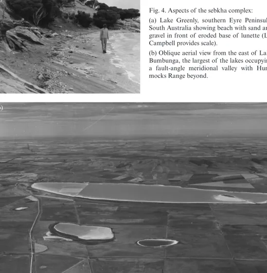
(8) 78 Bourne and Twidale. CAD. LAB. XEOL. LAXE 35 (2010). (a) Fig. 4. Aspects of the sebkha complex: (a) Lake Greenly, southern Eyre Peninsula, South Australia showing beach with sand and gravel in front of eroded base of lunette (Liz Campbell provides scale). (b) Oblique aerial view from the east of Lake Bumbunga, the largest of the lakes occupying a fault-angle meridional valley with Hummocks Range beyond.. (b). In southern Australia lunettes typically are located on the eastern margins of depressions (e.g. BOWLER, 1968; CAMPBELL, 1968; PAGE et al., 1993), though there are exceptions. For instance, the lunette bordering Kappakoola Swamp on northern Eyre Peninsula stands adjacent to the southern shore (SMITH et al., 1975). As mentioned, a major lunette stands adjacent to the northern shore of Lake Eyre North. (DULHUNTY, 1983), but elsewhere in central Australia, for instance around Lake Amadeus they are located on the southern sides of the playas or river channels (CHEN et al., 1991). In the far north, as for instance at Lake Woods, lunettes border the western shore. Similarly they stand on the western side of playas in the Lake Gregory complex of northern Western Australia (BOWLER, 1990, p. 6) but north of Esperance, on the.
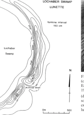
(9) CAD. LAB. XEOL. LAXE 35 (2010). (c). Playas of inland Australia 79. (d). Fig. 4. Aspects of the sebkha complex: (c) Form-line plan of lunette at Lochaber, in South East district, South Australia (after CAMPBELL, 1968). (d) Unnamed playa, Simpson Desert from the south, with Lake Eyre, extreme top left. Note dunes extending o n to southern shoreline of salina and lunette bordering northern margin (RAAF).. south coast of Western Australia, lunettes occur on the eastern side of depressions. COFFEY (1909) attributed the dunes to the deflation of lake beds located immediately upwind, but HILLS (1940) envisaged that lunettes formed when the lake depressions carried water. All the lunettes he studied were fine-grained (silty) and he suggested that air passing over the lake picked up moisture. Dust in suspension coagulated as a result of contact with moisture and halite, and was deposited on the lee shore (see also HILLS, 1939). This explanation became known as the ‘wet’ hypothesis because it involved a true lake, with water. Like Coffey, Hills offered no explanation for the lake depressions. Also the ‘wet’ hypothesis could not account for the many lunettes composed of sand or seed gypsum. Considering these mounds composed of coarser sediments,. STEPHENS and CROCKER (1946) returned to Coffey’s deflation hypothesis, arguing that silt and clay particles coagulated on the dry lake bed to form pellets subject to wind transport by saltation as well as deflation. The deflation or erosional hypothesis has the great advantage of simultaneously accounting for the lake depressions and the lunette. As would be expected if deflation had occurred, the composition of the lunette closely matches that of whatever sediments are found in the particular lake bed, with the exception of some fines lost to winnowing and preferential wind transport. But difficulties remained. First, comparison of the position of lunettes adjacent to playas in southern South Australia with local seasonal wind regimes, suggests that the mounds were deposited by winter winds (cf..
(10) 80 Bourne and Twidale. KILLIGREW and GILKES, 1974), when the playas of southern Australia, for example, most likely were covered by water, and not summer winds, as might be anticipated if airborne dust or the lake bed were the immediate source of the lunette deposits (CAMPBELL, 1968). That many playas carry an encrustation of salt (gypsum, halite) also poses problems, for it was difficult to understand how sand or silt (or of whatever sediment the local lunette is built) could have been deflated from beneath such a cover. A solution was suggested by CAMPBELL (1968) and BOWLER (1968) and, it transpired, and incidentally, by WOODS (1862, pp. 27-28). Working in the South East District of South Australia, Woods noted that flotsam was carried by wind-driven waves to the lee shores of lakes. Campbell made similar observations in the region around her childhood home, near Naracoorte, also in the South East. When the playa carried water the salt crust was dissolved. Thus the underlying sediment could be drifted by waves to the lee shore. Bowler’s discovery of gravel in lunettes also pointed to wave transport. The sediments deposited on the lee shore formed beaches from which the wind winnowed material of suitable size and carried it a short distance into vegetated areas where it was trapped and built up into immobile dunes or lunettes. Thus lunettes were interpreted as analogous to coastal foredunes. In this respect it is salutary to recall that when approaching the salina in July 1840, Eyre “found Lake Torrens completely girded by a steep sandy ridge, exactly like the sandy ridges bounding the sea shore…” (EYRE, 1845, I, p. 58)! Sebkha complexes like that at Lake Greenly (figure 4) on southern Eyre Peninsula fully conform to this hypothesis for a. CAD. LAB. XEOL. LAXE 35 (2010). beach rich in sand and gravel stands as the source from which the sandy lunette is derived. The multiple lunettes formed on some lee shores mark stages in the shrinkage of the particular lakes. The Campbell–Bowler hypothesis comparing lunettes to coastal foredunes explains the major characteristics of lunettes, but anomalies remain. For instance, not all playas in a given locality are bordered by lunettes. Some are, but others are not. It might be expected that a large lunette would be associated with a large playa but it is not necessarily so, for some small playas are bordered by large lunettes, and vice versa. But the coastal foredune comparison explains many of the field characteristics. Lunettes are widely represented in Australia and though best known from southern regions they occur in abundance also in the arid lands of the centre where they are associated with dry river channels as well as with playas. They play an important role in the generation of the linear sand dunes characteristic of the region (WOPFNER and TWIDALE, 1967, 1988; TWIDALE, 1972, 1981). Lunettes interfere with airflow causing deflection and turbulence, leading to the deposition in the lee of the topographic obstacle of ribbons of sand which coalesce downwind to form the linear sand ridges or dunes that dominate the Australian, and indeed the world’s, deserts. Working in the arid interior of Western Australia, JUTSON (1914, 1917) attributed ‘billiard table’ bedrock surfaces associated with salinas to the work of wind, waves and salt. He thought that salt from the salinas ate into and disrupted the rocks exposed at the western margin of the deflation hollows. The wind not only removed the debris but also caused the westerly migration of the.
(11) CAD. LAB. XEOL. LAXE 35 (2010). playas. In addition to such deflational features, Jutson recognised that some playas occupied deformational hollows – salinas caused by minor, local faulting or warping, by structural effects. The structural factor JENNINGS and MABBUTT (1977, p. 39) claimed that the larger playas of the Australian interior owe their origins to geologically-young faulting. Active faulting (tectonism) can form depressions such as rift valleys, graben or sunklands, fault angle valleys or half-graben and sag ponds, all of which are potential sites for playas. Faults can be passive, first, because they can be zones of weakness exploited by weathering and erosion, and second, by bringing into juxtaposition rocks of contrasted susceptibility to weathering and erosion, again causing the development of topographic depressions that become playas. Faults influence the formation of river patterns some of which again have become the sites of playa development. Thus, the relationship between faults and playas is widespread but varied, frequently indirect, and commonly difficult to ascertain with certainty. But whatever their origin, the playas are depocentres and areas of salt accumulation and precipitation. At one end of the scale a small sag pond is occupied by a dry marsh on the Ash Reef Fault, on northeastern Eyre Peninsula (MILES, 1952; HUTTON et al., 1994). At the other extreme is Lake Eyre (JOHNS, 1963), a salina some 3600 km2 in extent and underlain by some 80 metres of Cenozoic. Playas of inland Australia 81. beds overlying a thick sequence of Cretaceous strata. TIMMS (1993, pp. 45-46) cites Lake Eyre North as of tectonic origin, but attributes it to warping in the crust. This is incorrect. It is downfaulted and has resulted in the bed of Lake Eyre South being some 15-16 m below sea level (DULHUNTY, 1987). The precise location and value of the lowest point varies according to the most recent cycle of flooding, solution, desiccation, and salt precipitation and crystallisation. Whether the downfaulted block is a graben or half-graben (fault-angle depression) remains unclear, but certain it is that the salina is delimited on its western side by a fault scarp (figures 2 and 5). The evidence is varied (JOHNS, 1963; WOPFNER and TWIDALE, 1967; TWIDALE 1972). Though intricately dissected the scarp is linear. The scarp is capped by a 2 m-thick bed of coarsely crystalline gypsum underlain by friable gypsiferous silts, a sequence that is intersected at shallow depth beneath the adjacent salt bed. The mound springs that emerge on the bed are not randomly distributed but occur in rows. The so-called Warburton Groove is not winding, as depicted on some early maps (presumably because the Warburton River there debouches on the lake bed and as rivers are winding, so must the channel also be sinuous!) but straight and in parallel not only with the western scarp (figure 5b), but also with known faults to the west (REYNER, 1955; WOPFNER, 1968; AMBROSE et al., 1993). The area is seismically active (e.g. YOUNGS and WOPFNER, 1972; GREENHALGH et al., 1994)..
(12) 82 Bourne and Twidale. (a). CAD. LAB. XEOL. LAXE 35 (2010). Fig. 5 (a) Warburton Groove in the northwest corner of Lake Eyre, South Australia (RAAF). Note this is a linear feature, probably fault-controlled. (b) Cliffs of gypsiferous silts capped by gypcrete, western shore of Lake Eyre (photograph courtesy The Advertiser, Advertiser Newspapers). (b).
(13) CAD. LAB. XEOL. LAXE 35 (2010). The nature of the eastern edge of the salina is uncertain. In an immediate sense it is depositional with the detritus of several large rivers deposited to form a flat and irregular shore. Whether these rivers have partly eroded and partly blanketed a cliffline comparable to that exposed to the west is not known. Lake Eyre occupies a depocentre and is the focus of a drainage system that occupies about 1.4 million km2 of central and northern Australia. The catchment includes such rivers as the Georgina and Diamantina that rise in the monsoonal north. Evidently the lake fills in whole or in part if the rivers run in two or more successive years, and this occurs three or four times a century (see e.g. LAKE EYRE COMMITTEE, 1955; BONYTHON and MASON, 1953; KOTWICKI, 1986). The first rains and flood clears the channels of rivers flowing to the Lake, and bring soils to field capacity. The second spate may reach the bed of the Lake. Taking a longer temporal perspective, a chronology of full and dry phases has been recorded extending over the past 150,000 years (MAGEE et al., 2004). Lake Frome, some 2330 km2 and occurring some 20 m above sea level, is a downfaulted embayment developed along a fault zone that coincides with its eastern shore. It is underlain by some 160 m of Cenozoic beds. Lake Torrens, some 5830 km2 and about 34 m above sea level, occupies a depression that was initiated by subsidence along the Torrens Fault or Lineament in the Early Eocene or Late Cretaceous. Originally occupied by lake sediments, it was later a depocentre for alluvium from the Arcoona Plateau and the Flinders Ranges. Recent aridity has produced a crust of gypsum and halite, but some 16 m below the. Playas of inland Australia 83. surface and 5 km from the eastern shoreline there is a bed of gypsum some 12 m thick (JOHNS, 1968). The salina is bordered on its western side by a major fault zone known as the Torrens Lineament, which is gently arcuate and abruptly defines the Arcoona Plateau which is a dissected region developed on a sequence of very gently-dipping Neoproterozoic quartzites and siltstones. A series of springs occur in a line on the bed of the salina running southeast of Andamooka Island. The abrupt and rocky western shore of the gypseous salina stands in marked contrast with the depositional eastern shore, which is bordered by a kopi dune and a number of deltaic deposits associated with several episodic streams draining the Flinders Ranges. Silcrete is preserved in valleys draining to the salina from the Arcoona Plateau (TWIDALE et al., 1970). More moderate in extent but significant for the area east of The Hummocks Ranges, Lake Bumbunga, some 25–35 km NNE of the head of Gulf St Vincent, and a series of associated unnamed small salinas are of similar origin for they are developed in a half graben. The Lake is bordered on its western shore by an Eocene fault zone characterised by springs as well as linearity, and on the east by a kopi dune. On the other hand, the salina carries a crust of halite which is commercially harvested from evaporation fields or pans at the southern end of the playa. Flat-topped islands stand some 4–5m above the present lake bed and indicate the minimum amount of detritus that has been eroded and reworked into the lunette (see below). Lakes Frome and Gilles also are partly defined by linear shorelines which may be coincident with and underlain by fault zones..
(14) 84 Bourne and Twidale. CAD. LAB. XEOL. LAXE 35 (2010). Playa Present day drainage Palaeodrainage. ">.... Palaeodrainage on Bunda Plateau. ................ Present day divide; Cowan drainage basin. Major drainage divide. Meckering Limit 01 south ceast rejuvenation Eocene shoreline scarp. Miocene shoreline Eocene marine sediment. N. Okm. 250. Fig. 6. Map of Western Australia, showing palaeochannels of Eocene age and major playas (after VAN DE GRAAFF et al., 1977)..
(15) CAD. LAB. XEOL. LAXE 35 (2010). Several large salinas such as Lake MacFarlane, Pernatty Lagoon, and Island Lagoon are suspected of having developed along faults because each has one shoreline that is linear or gently arcuate and aligned in concordance with known regional fractures, in this instance the Torrens Lineament (figure 2). The eastern shoreline of Lake Gairdner also falls into this category (but it also provides an example of another aspect of faulting that is considered later). But whether they occupy half grabens or are simply depressions caused by preferential weathering and erosion along fault zones is not known. In addition to a depression forming during dislocation, however, the accumulation of water must cause weathering of the strata, possibly resulting in volume decrease, compaction and surface subsidence (TRENDALL, 1962), so that the initial depression is enhanced. Earth movements have also caused blocked drainage and playa development. In the southwest of Western Australia, uplift of the southern coastal zone consequent on the separation of Australia and Antarctica in the later Mesozoic and earliest Cenozoic caused rivers that had flowed southwards to be diverted to the north. Later, aridity caused their courses to be blocked and dismembered with many salinas, large and small, forming in the previous channels and valleys. Examples include the Lefroy palaeoriver and the Johnston Lakes systems, and lakes Monger, Moore and Barlee from the arid interior (figures 1 and 6). The major river channels of the Yilgarn Block or Craton are of earliest Cenozoic age, for sediments of Eocene age are preserved in some (VAN DE GRAAFF et al., 1977; CLARKE, 1994; see also SALAMA, 1997). Many of these and other river pat-. Playas of inland Australia 85. terns are structurally controlled. Some like the arms of the zigzag Percival lakes system are linear and are associated with essentially straight fractures (figure 6). Others, however, are arcuate and are thought to be related to arcuate or circular (ring) structures in the crust (O’DRISCOLL and CAMPBELL, 1997; WOODALL, 1994; also KAMININE and RICHTER, 1956). Thus in the southwest of Western Australia the Lefroy, Yindarlgooda and Raeside palaeorivers describe a concentric pattern. In South Australia, the string of ‘paternoster’ lakes between lakes Labyrinth and Younghusband, to the north of Kingoonya is another example, and lakes Frome, Callabonna, Blanche and Gregory can be construed as occurring on an arcuate structure. Mound springs mark the upwelling of artesian waters along fault zones and some sinkholes or dolines developed in lateritic terrains on the Sturt Plateau, south of Katherine in the north of the Northern Territory, are developed in valley floors and along minor fractures: hence the aligned pattern of many of the circular depressions. Many, like Frews Water Hole located some 300 km southeast of Katherine (STUART, 1863, p. 25), carry water during and following the summer monsoon season but some are converted to claypans during the winter dry season. Blocked and dismembered drainage depressions Lake Gairdner is a salina about 160 km long that occupies an area of almost 9000 km2 in an old fracture-controlled valley in the Mesoproterozoic silicic volcanic rocks of the Gawler Ranges massif (JOHNS, 1968; figure 2). There was a major uplift of the.
(16) 86 Bourne and Twidale. linear southern and southwestern margin of the massif during the Cretaceous when Australia separated from Antarctica. The orientation of the tributary valleys suggest the Gairdner palaeoriver first drained north but it was blocked by faulting (WNW-ESE trend), indicated by linear structures and dislocations near its northern extremity, and the river was diverted southwards and ran via the Thurlga palaeochannel to the Corrobinnie Depression. They have been reactivated when minor uplift, as evidenced by an observed dislocation (TURNER, 1975) and exposed platforms and flared slopes, some 3-4 m above present piedmont plain level, caused blockage and the formation of the salina with a halite crust (figure 7a; see also frontispiece) underlain by up to 20 m of gypsiferous silts. Silcrete, which is commonly found in and adjacent to lake basins (OPIK, 1954), occurs on the western shore. Sandy lunettes have been constructed on the eastern shore and the lake bed and shores provide fine examples of haloclastic forms and particularly etched and bevelled cobbles and blocks (figures 7b and 7c).. Fig. 7. Lake Gairdner, northern Eyre Peninsula, South Australia: (a) pressure ridges in halite on bed of salina, (b) part of eastern shoreline showing salt-encrusted beach in embayment between rocky promontories, and undercut blocks of Gawler Range Volcanics, and (c) boulder transported to the lake bed, presumably by stream in flood, showing marked undercutting by haloclasty, or salt crystal precipitation and expansion (E.M. Campbell).. CAD. LAB. XEOL. LAXE 35 (2010).
(17) CAD. LAB. XEOL. LAXE 35 (2010). Playas associated with dismembered drainage systems are common in the Australian interior. River systems developed during past humid climatic periods were revived during the infrequent and brief but effective periods of rainfall and runoff of arid climatic regimes. With the onset of aridity, however, the rivers ceased to flow at the surface. The rivers broke down into a series of pools and shoals, and with the cessation of surface flow pools became isolated and eventually came to be bordered by lunettes.. Playas of inland Australia 87. The pools also filled during rains and shortlived phases of runoff. Many fine examples of salinas derived from the dismemberment of former rivers are found in the Yilgarn Block of southwestern Western Australia, and in the Menindee and Willandra systems of southwestern New South Wales. The latter includes Lake Mungo and its associated lunette (figure 8), which is well-known for its ancient human remains (see e.g. BOWLER et al., 2003).. Fig. 8. (a) Map of Willandra and Menindee palaeodrainage..
(18) 88 Bourne and Twidale. CAD. LAB. XEOL. LAXE 35 (2010). Fig. 8. (b) Oblique air photograph of portion of The Wall of China, the lunette, bordering Lake Mungo on the east (J.M. Bowler).. Many dismembered river channels and valleys were blocked as sebkha complexes formed but blockages also arose in other ways. For instance, the Corrobinnie Fault Zone that delimits the Gawler Ranges massif on its southern side, was exploited by weathering and erosion forming the Corrobinnie Depression (BOURNE et al., 1974). It was drained by the Narlaby stream system during the Eocene and Pliocene (BINKS and HOOPER, 1984). The Narlaby palaeoriver reached the southern ocean via what is now Smoky Bay, on the northwest coast of Eyre Peninsula. A channel is still discernible in the floor of the Bay. But during glacial phases of low sea level in the Middle and Late Pleistocene (WILSON, 1991),. a thick and extensive sequence of calcareous coastal foredunes was deposited along the west coast of Eyre Peninsula. This blocked the Narlaby drainage, which however continued to receive runoff and sediments from the Gawler Ranges to the north and the granitic terrains of northern Eyre Peninsula to the south. With the onset of aridity the streams were dismembered and the remnants now form the many salinas found in the Depression while the sands of the broad flood plain were blown into complex parabolic dunes. The west coast field of coastal foredunes also blocked drainage further south on Eyre Peninsula to produce lakes Wangary, Greenly and Malata as well as numerous smaller salinas (e.g. DUTKIEWICZ.
(19) CAD. LAB. XEOL. LAXE 35 (2010). and VON DER BORCH, 1995; DUTKIEWICZ et al., 2002). As many stream patterns are determined by local structure, and especially fracture patterns, many of the playas derived from the break-up of stream systems also are structurally determined. Thus Lake Amadeus stands in a former valley that ran NWSE from the Lake MacDonald and Lake Neale area to the Lake Eyre Basin (CHEN et al., 1991). It may be fault–controlled. Lakes Everard and Harris also appear to occupy former valley systems. In the north of Western Australia, Lake Gregory appears to be a relic of another complex fracture-controlled drainage system (e.g. ALLEN, 1990), whereas lakes Carnegie and Wells are remnants of what were rivers following or underprinted from arcuate fractures. HUMAN ASPECTS Obviously what salts precipitate out of solution depends on what were in solution, and this varies to some extent with local and regional geology, and the products of rock weathering released into groundwaters. Beds of halite and gypsum are obvious sources but many soluble salts are released by the alteration of lithified materials. At a regional scale the lakes and salinas of southwestern United States and the African Rift Valley, for example, contain salts of great and unusual variety as a result of recent and active volcanicity. Moreover, salts originating in sea spray or scoured from existing salt pans and recycled are carried long distances on the wind – cyclic salt (e.g. JACK, 1921; HUTTON, 1976). Artesian waters also vary in composition. In particular, those of the western Great Australian or Artesian Basin are relatively rich in sulphate (HABER-. Playas of inland Australia 89. MEHL, 1980) so that the waters of mound springs that originate in this source may also be expected to be rich in sulphate and emit ‘bad egg’ odours (see BOYD, 1990). But superimposed on and overriding such considerations, most salts originate in the oceans and are carried inland on the wind, though gypsum is highly soluble and sulphites are found in commonly-occurring minerals such as pyrite (FeSi) to react with carbonates to form gypsum. Thus, the nature of salts in solution in seawater is crucial to any consideration of terrestrial salts and salinas. In enclosed basins (either natural or man-made) subject to evaporation the order of precipitation and crystallisation is well known, and is in reverse order of solubility. Carbonates of iron and calcium are first precipitated followed by calcium sulphate (when 20% of the brine remains), and sodium chloride (10%), with salts of magnesium and potassium remaining as an extremely alkaline solution known as bittern. Given that both gypsum and halite are widely distributed over the landscape, that both are soluble, and that groundwaters gravitate to low points in the topography resulting in gypsum precipitating out first. The less dense halite (SG 2.2; as compared to gypsum, 2.3) remains as brine, which after further evaporation precipitates to form a crust of halite. But there is a wide window (between 20% and 10% of original solute volume) in which gypsum precipitates. Hence the wide distribution of the sulphate for it forms at the margins even of playas dominated by halite. It is weathered and the crystalline form is reduced to seed and flour gypsum by attrition of the corners and edges of the crystals (JACK, 1921, p. 90)..
(20) 90 Bourne and Twidale. Salinas are also of considerable economic importance. DE DECKKER (1983, p. 235) stated that by contrast with the salinas of other continents Australian salt lakes are uniformly sodium-chloride-rich. Certainly most carry a crust dominated by, and even overwhelmingly composed of, sodium chloride or common salt (e.g. SALAMA et al., 1992), but these surficial deposits are underlain by gypsum. In some, like the playas that are strewn along the axis of what might be called the Amadeus corridor of central Australia (JACOBSON and LAU, 1987), gypsum and carbonate (gypcrete and calcrete) occur at the surface, and many other salinas, such as Lake Gilles on northern Eyre Peninsula, also are noted for their gypsum crystals. Many halite flats such as Lake Bumbunga (Mid North of South Australia) and Lake Fowler (southern Yorke Peninsula) are bordered by lunettes or kopi dunes composed of flour or seed gypsum. The kopi dunes worked at Cooke Plains are associated with past stands of Lake Alexandrina. Thus, though halite is a commonplace, gypsum is quantitatively dominant. For instance, BONYTHON (1956) estimated that in and beneath the bed of Lake Eyre there is ten times as much gypsum as there is halite - 4000 million tons [3800 tonnes] as compared with 400 million tons (plus some 7 million tons of magnesium and potassium salts). Similarly, JOHNS (1968) was of the opinion that South Australian playas are predominantly gypsiferous with only small areas of halite crust. For humans, common salt, sodium chloride, is one of the most important of all minerals. It is an essential ingredient of human diet and for this reason has throughout recorded history and earlier been transported long distances to regions lacking a local supply. So valuable was it that it has taken its place in. CAD. LAB. XEOL. LAXE 35 (2010). our language, as in the word ‘salary’, and ‘He is the salt of the Earth’ (Matthew 5:13), an expression used if a person is favoured, but ‘not worth his salt’ if not. Common salt was widely used as a preservative until the widespread availability of refrigeration and is still utilised where modern technology is not accessible. It is used in the manufacture of a wide variety of products from glass to plastics. But salts other than halite also are useful. Gypsum, in particular, is used for the manufacture of Plaster of Paris, and Portland cement, but also and widely in agriculture and gardening, for it flocculates clays and thus improves soil texture. The sea is the main source of both halite and gypsum, with many coastal sites either exploited, adapted or constructed for the trapping of sea water and allowing evaporation to bring the salts out of solution. South Australia is responsible for some 80% of Australia’s salt production, and most of it is obtained from coastal pans at sites like Dry Creek (near Adelaide) and Price on northern Yorke Peninsula. Lake MacDonnell, west of Ceduna on western Eyre Peninsula, is the main source of gypsum for that area, as is the locally exploited Lake Gilles for northeastern Eyre Peninsula. Gypsum in commercial quantities is excavated from Cooke Plains near the Lakes at the mouth of the River Murray. Many small salinas have been exploited in the interior semiarid regions of the southern States of Australia. The Merredin area of Western Australia, the Griffith area of N.S.W., Mildura in Victoria, and lakes Fowler and Bumbunga in South Australia are examples of sources with accessible supplies close enough to users for harvesting to be economically viable, but there are numerous small deposits that are farmed to satisfy local needs. There are huge reserves in major.
(21) CAD. LAB. XEOL. LAXE 35 (2010). Playas of inland Australia 91. interior salinas though they are located at sites too remote to warrant exploitation at present. Again, at the local level, lunettes bordering salinas in the South East district of South Australia are dry sites in a winter wetland, so that pastoral homesteads frequently are sited on such slight but significant topographic rises.. Regattas were held during the 1974 flooding of Lake Eyre. On the other hand, in 1964 an attempt was made to set the world land speed record using the flat, dry surface of Lake Eyre, and Lake Gairdner is similarly utilised annually since 1990 for motor cycle speed races and record attempts.. PLAYAS IN FLOOD. All lakes are ephemeral but these Australian playas are more ephemeral than most. Surely rather than call the various playas ‘lakes’, as is the present cartographic practice, it would be would be more realistic to call them all playas. Attempts to differentiate salinas and claypans might at this stage of our knowledge be too late and hence too difficult. But however they are labelled Australian playas clearly vary in origin and multiple causations can be cited for many. Such an analysis is highly appropriate to this memorial volume. Not only was Liz Campbell’s family home at Binnum near Naracoorte, in the South East district of South Australia, located on a lunette, as part of a sebkha complex, but playas in general, and the Lake Gairdner salina in particular, were her principal research interests over the last 15-20 years of her life.. On many maps these Australian ‘lakes’ are coloured not blue for water but, and appropriately, white, for salt; for most of the ‘lakes’ are playas and most of these are salinas. But from time to time even in the present arid climatic regime the rivers run and the lakes fill and live up to their name. It is true that the ‘lakes’ are water bodies only for a few days, weeks or months after heavy rains in the locality of the playa or within the catchment of which the playa is the focus. Lacustrine plants and animals miraculously come to life and for a short time the lakes bloom. Even more astonishing are the coastal changes, for as was shown during the well documented 1974 filling of the Lake (KOTWICKI, 1986), depositional features such as beaches, spits, and bars, develop and change markedly and with surprising rapidity. This observation is germane to the interpretation of landscape and climatic chronology. For instance, DULHUNTY (1975, 1990) has recorded the presence of shingle beaches standing 280, 160 and 70 cm above the maximum level of the 1974 filling, but they may attest brief lake fillings following heavy rains somewhere in the catchment (which includes monsoonal northern Australia) rather than a secular or long-term humid climatic phase.. CONCLUSION. ACKNOWLEDGEMENT The authors thank Keith Johns for reading an early draft of this paper and giving us the benefit of the extensive field knowledge gained when working for the Geological Survey of South Australia, and Debbie Hagger for drafting the figures with her usual expertise and discerning eye from our very rough hand-drawn versions..
(22) 92 Bourne and Twidale. REFERENCES ALLEN, A. D. (1990). The inferred hydrogeology of Lake Gregory. In: The Natural Features of Lake Gregory: a Preliminary Review. S.A. Halse (Ed.). Department of Conservation and Land Management, Perth, Occasional Paper 2/90, p. 1-4. AMBROSE, J. W., FLINT, R. B. and WEBB, A. W. (1981). Precambrian and Palaeozoic Geology of the Peake and Denison Ranges. Geological Survey of South Australia Bulletin 50. BATES, R. L. and JACKSON, J. A. (1987). Glossary of Geology. Third edition, American Geological Institute, Alexandria, VA. BAYLY, I.A.E. and WILLIAMS, W.D. (1973). Inland Waters and their Ecology. Longmans, Melbourne. BENBOW, M. C. (1982). Coober Pedy, South Australia, sheet SH 53-6. 1:250,000 Geological Series, Explanatory Notes. Geological Survey of South Australia, Adelaide. BENBOW, M. C. (1993). Tallaringa, South Australia, sheet SH 53-5. 1:250,000 Geological Series, Explanatory Notes. Geological Survey of South Australia, Adelaide. BINKS, P. J. and HOOPER, G. J. (1984). Uranium in Tertiary palaeochannels, ‘West Coast Area’, South Australia. Proceedings of the Australasian Institute of Mining and Metallurgy, 289: 271-275. BLACKWELDER, E. (1934). Yardangs. Geological Society of America Bulletin, 24: 159-166. BLISSETT, A. H. (1985). Gairdner, South Australia Explanatory Notes, 1:250,000 Geological Series, Sheet SH/53-15 International Index. Department of Mines. CAD. LAB. XEOL. LAXE 35 (2010). and Energy, South Australia. BOBECK, H. (1969). Zur Kenntnis der Sudlichen Lut. Ergebnisse einer Luftbildanalyse. Mitteilungen der Österreichischen Geographischen Gesellschahft, 111: 155-192 BONYTHON, C. W. (1956). The salt of Lake Eyre - its occurrence in Madigan Gulf and its possible origin. Transactions of the Royal Society of South Australia, 79: 66-92. BONYTHON, C. W. and MASON, B. (1953). The filling and drying of Lake Eyre. Geographical Journal, 119: 321330. BOULAINE, J. (1954). La sebkha de Ben Ziane et sa “lunette” ou bourrelet. Revue Géomorphologie Dynamique, 5: 102-123. BOURNE, J. A., TWIDALE, C. R. and SMITH, D. M. (1974). The Corrobinnie Depression, Eyre Peninsula, South Australia. Transactions of the Royal Society of South Australia, 98: 139-152. BOWLER, J. M. (1968). Australian Landform Example No. 11. Lunette. Australian Geographer, 10: 402-404. BOWLER, J. M. (1981). Australian salt lakes. Hydrobiologia, 82: 431-444. BOWLER, J. M. (1990). Lake Gregory - geomoprphology and paleohydrology. In: The Natural Features of Lake Gregory: a Preliminary Review. S.A. Halse (Ed.). Department of Conservation and Land Management, Perth, Occasional Paper 2/90, p. 5-10. BOWLER, J. M., JOHNSTON, H., OLLEY, J. M., PRESCOTT, J. R., ROBERTS, R. G., SHAWCROSS, W. and SPOONER, N. A. 2003. New ages fo human occupation and climatic change at Lake Mungo, Austalia. Nature, 421: 837-840. BOYD, W. E. (1990). Mound springs. In:.
(23) CAD. LAB. XEOL. LAXE 35 (2010). Natural History of the North East Deserts. M.J. Tyler, C.R. Twidale, M. Davies and C.B. Wells (Eds). Royal Society of South Australia, Adelaide, p. 107-118. BREED, C. S., McCAULEY, J. F. and WHITNEY, M. I. (1989). Wind erosion forms. In: Arid Zone Geomorphology. D.S.G. Thomas (Ed.). Belhaven, London, p. 284-307. CAMPBELL, E. M. (1968). Lunettes in southern South Australia. Transactions of the Royal Society of South Australia, 92: 85-109. CHEN, X. Y., BOWLER, J. M. and MAGEE, J. W. (1991). Aeolian landscapes in central Australia: gypsiferous and quartz dune environments from Lake Amadeus. Sedimentology, 38: 519-538. CLARKE, J. D. A. (1994). Lake Lefroy, a palaeodrainage playa in Western Australia. Australian Journal of Earth Sciences, 41: 417-427. CLOUDSLEY-THOMPSON, J. L. (1965). Desert Life. Pergamon Press, Oxford. COFFEY, G. N. (1909). Clay dunes. Journal of Geology, 17: 754-755. COWLEY, W. M. and MARTIN, A. R. (1991). Explanatory Notes Kingoonya South Australia, 1:250,000 Geological Series, Sheet SH53-11 International Index. Department of Mines and Energy, South Australia. CRAWFORD, A. R. (1965). The Geology of Yorke Peninsula. Geological Survey of South Australia Bulletin, 39. DE DECKKER, P. (1983). Australian salt lakes: their history, chemistry, and biota – a review. Hydrobiologia, 105: 231-244. DERRUAU, M. (1956). Les formes périglaciaires du Labrador-Ungava centrale comparées a celles de l’Islande centrale. Revue de Géomorphologie Dynamique, 5: 11-16.. Playas of inland Australia 93. DULHUNTY, J. A. (1975). Shoreline shingle terraces and prehistoric fillings of Lake Eyre. Transactions of the Royal Society of South Australia, 99: 183-188. DULHUNTY, J. A., (1983). Lunettes of Lake Eyre North, South Australia. Transactions of the Royal Society of South Australia, 107: 219-222. DULHUNTY, J. A. (1987). Salina bed instability and geodetic studies at Lake Eyre, South Australia. Transactions of the Royal Society of South Australia, 111: 183-188. DULHUNTY, J. A. (1990). Lake Eyre. In: Natural History of the North-Eastern Deserts. M.J. Tyler, C.R. Twidale, M. Davies and C.B. Wells, (Eds). Royal Society of South Australia, Adelaide, p. 101-106. DUTKIEWICZ, A. and VON DER BORCH, C. C. (1995). Lake Greenly, Eyre Peninsula, South Australia: sedimentology, palaeoclimatic and palaeohydrologic cycles. Palaeogeography, Palaeoclimatology, Palaeoecology, 113: 43-56. DUTKIEWICZ, A., VON DER BORCH, C. C. and PRESCOTT, J. R. (2002). Geomorphology of the Lake Malata-Lake Greenly complex, South Australia, and its implications for Late Quaternary palaeoclimate. Transactions of the Royal Society of South Australia, 126: 103-115. EGAN, T. (2006). The Worst Hard Time. The Untold Story of Those Who Survived the Great American Dust Bowl. Houghton Mifflin, Boston..
(24) 94 Bourne and Twidale. EYRE, E. J. (1845). Journals of Expeditions of Discovery into Central Australia and Overland from Adelaide to King George’s Sound, in the years 1840-41. T. and W. Boone, London, 2 volumes. FOREL, F. A. (1892). Le Leman: Monographie Limnologie. Tome 1. Geographie, Hydrographie, Geologie, Climatologie, Hydrologie. F. Rouge, Lausanne. GILBERT, G. K. (1904). Domes and dome structures of the High Sierra. Geological Society of America Bulletin, 15: 29-36. GREENHALGH, S. A., LOVE, D., MALPAS, K. and McDOUGALL, R. (1994). South Australian earthquakes 1980-92. Australian Journal of Earth Sciences, 41: 483-495. HABERMEHL, M. A. (1980). The Great Artesian Basin, Australia. Bureau of Mineral Resources Journal of Australian Geology and Geophysics, 5 (1): 8-38. HARRIS, W. J. (1939). Physiography of the Echuca district. Proceedings of the Royal Society of Victoria, 51: 45-60. HILLS, E. S. (1939). The physiography of north-western Victoria. Proceedings of the Royal Society of Victoria, 51: 297323. HILLS, E. S. (1940). The lunette, a new landform of aeolian origin. Australian Geographer, 3: 15—21. HOLMES, A. (1965). Principles of Physical Geology. Nelson, London. HUME, W. F. (1925). Geology of Egypt. Volume I. Government Printer, Cairo. HUTTON, J. T. (1976). Chloride in rainfall in relation to distance from the ocean. Search, 7: 207-208. HUTTON, J. T., PRESCOTT, J. R., BOWMAN, J. R., DUNHAM, M. N. E., CRONE, A. J., MACHETTE, M. N. and TWIDALE, C. R. (1994). Thermolumi-. CAD. LAB. XEOL. LAXE 35 (2010). nescence dating of Australian palaeoearthquakes. Quaternary Geochronology (Quaternary Science Reviews), 13: 143147. JACK, R. L. (1921). The salt and gypsum resources of South Australia. Geological Survey of South Australia Bulletin, 8. JACK, R. L. (1931). Report on the geology of the region to the north and north-west of Tarcoola. Geological Survey of South Australia Bulletin, 15. JACOBSON, G. and LAU, J. E. (compilers) (1987). Hydrology of Australia. Scale 1:5,000,000. Bureau of Mineral Resources, Canberra. JENNINGS, J. N. and MABBUTT, J. A. (1977). Physiographic outlines and regions. In: Australia: A Geography. D.N. Jeans (Ed.). Sydney University Press, Sydney, p. 38-52. JOHNS, R. K. (1963). Investigation of Lake Eyre. Part 1. The sediments of the Lake Eyre basin, evaporites and brines, their constitution and age. Geological Survey of South Australia Report of Investigations, 24. JOHNS, R. K. (1968). Investigation of lakes Torrens and Gairdner. Geological Survey of South Australia Report of Investigations, 31. JUTSON, J. T. (1914). An outline of the physiographical geology (physiography) of Western Australia: Geological Survey of Western Australia Bulletin, 61. JUTSON, J. T. (1917). Erosion and the resulting land forms in sub-arid Western Australia, including the origin and growth of the dry lakes. Geographical Journal, 50: 418-434. KAMININE, G. D. and RICHTER, L. G. (1956). Caractéristique comparative morphologique des boucliers de la par-.
(25) CAD. LAB. XEOL. LAXE 35 (2010). tie Européenne del URSS. In: Essais de Géographie. Academie des Sciences de l’URSS, Moscow, p. 82-92. KEYES, C. R. (1912). Deflative systems of the geographical cycle in an arid climate. Geological Society of America Bulletin, 23: 537-562. KILLIGREW, L. P. and GILKES, R. J. (1974). Development of playa lakes in south Western Australia. Nature 247, February: 454-455. KING, C. A. M. (1956). The coast of southeast Iceland near Ingolfshofdi. Geographical Journal, 122: 241-246. KOTWICKI, V. (1986). Floods of Lake Eyre. Engineering and Water Supply Department, Adelaide. LAKE EYRE COMMITTEE, 1950 (1955). Lake Eyre, South Australia. The Great Flooding of 1949-50. The Royal Geographical Society of Australasia, South Australian Branch, Adelaide. LAMPLUGH, G. W. (1917). Discussion: J. T. Jutson (1917) Erosion and the resulting land forms in semi-arid Western Australia, including the origin and growth of the dry lakes. Geographical Journal, 50: 434-435. MAGEE, J. W., MILLER, G. H., SPOONER, N. A. and QUESTIAUX, D. (2004). Continuous 150 ky monsoon record from Lake Eyre, Australia: insolation forcing implications and unexpected Holocene failure. Geology, 32: 885—888. MAJOR, R. B. (1993). Woodroffe South Australia. Explanatory Notes 1:250,000 Geological Series, Sheet SG52-12 International Index. Department of Mines Geological Survey of South Australia, Adelaide. MILES, K. R. (1952). Tertiary faulting on northeastern Eyre Peninsula, South Aus-. Playas of inland Australia 95. tralia. Transactions of the Royal Society of South Australia, 75: 89-96. MINCHAM, H. (1964). The Story of the Flinders Ranges. Rigby, Adelaide. MITCHELL, T. L. (1839). Three expeditions into the interior of eastern Australia: with descriptions of the recently explored region of Australia Felix, and of the present colony of New South Wales. Volume 2, Boone, London. NICHOLS, R. L. (1969). Geomorphology of Inglefield land, north Greenland. Meddelelser om Grønland, 188. O’DRISCOLL, E. S. T. and CAMPBELL, I. B. (1997). Mineral deposits related to Australian continental ring and rift structures with some terrestrial and planetary analogies. Global Tectonics and Metallogeny, 6: 83-101. OPIK, A. A. (1954). Mesozoic plant-bearing sandstones of the Camooweal region and the origin of freshwater quartzite. Bureau of Mineral Resources Technical Report. PAGE, K., DARE-EDWARDS, A., NANSON, G. and PRICE, D. (1993). Late Quaternary evolution of Lake Urana, New South Wales, Australia. Journal of Quaternary Science, 9: 47-57. PASSARGE, S. (1904). Die Kalahari. Reimer, Berlin, 2 volumes. REYNER, M. L. (1955) The geology of the Peake and Denison region. Geological Survey of South Australia Report of Investigations, 6. RUSSELL, R. J. (1932). Landforms of San Gorgiono Pass, southern California. University of California (Berkeley) Publications in Geography, 6: 37-44. SALAMA, R., BARBER, C., HOSKING, J. and BRIEGEL, D. (1992). Geochemical evolution of Lake Deborah East,.
(26) 96 Bourne and Twidale. prototype salt lake in the relict drainage of the Yilgarn River of Western Australia. Australian Journal of Earth Sciences, 39: 577-590. SALAMA, R. B. (1997). Geomorphology, geology and palaeohydrology of the broad alluvial valleys of the Salt River System, Western Australia. Australian Journal of Earth Sciences, 44: 751-765. SMITH, D. M., TWIDALE, C. R. and BOURNE, J. A. (1975). Kappakoola dunes – aeolian landforms induced by man. Australian Geographer, 13: 90-96. STEPHENS, C. G. and CROCKER, R. L. (1946). Composition and genesis of lunettes. Transactions of the Royal Society of South Australia, 70: 302-312. STUART, J. M. (1863). J. McDouall Stuart’s Explorations across the Continent of Australia 1861-62. (Stuart’s diary of the exploration), F.F. Bailliere, Melbourne. STURT, C. (1849). Narrative of an Expedition into Central Australia performed under the Authority of Her Majesty’s Government during the years 1844, 5, and 6, 2 volumes, T. & W. Boone, London. TIMMS, B. V. (1993). Lake Geomorphology. Gleneagles Publishing, Adelaide. TRENDALL, A. F. (1962). The formation of ‘apparent peneplains’ by a process of combined lateritisation and surface wash. Zeitschrift für Geomorphologie, 6 (2): 183-197. TRICART, J. (1954a). Influence des sols salés sur la deflation éolienne en Basse Mauritannie et dans le delta du Senegal. Revue de Geomorphologie Dynamique, 5: 124-132. TRICART, J. (1954b). Une forme de relief climatique: les sebkhas. Revue de Geomorphologie Dynamique, 5: 97-101.. CAD. LAB. XEOL. LAXE 35 (2010). TURNER, A. R. (1975). The petrology of the eastern Gawler Ranges volcanic complex. Geological Survey of South Australia Bulletin, 45. TWIDALE, C. R. (1972). Landform development in the Lake Eyre region, Australia. Geographical Review, 62 (1): 40-70. TWIDALE, C. R. (1981). Age and origin of longitudinal dunes in the Simpson and other sand ridge deserts. Die Erde, 112 (3-4): 231-247. TWIDALE, C. R. (1987). Sinkholes (dolines) in lateritised sediments, western Sturt Plateau, Northern Territory, Australia. Geomorphology, 1: 33-52. TWIDALE, C. R., SHEPHERD, J. A. and THOMSON, R. M. (1970). Geomorphology of the southern part of the Arcoona Plateau and the Tent Hill region, west and north of Port Augusta, South Australia. Transactions of the Royal Society of South Australia, 94: 55-67. TYLER, M. J., TWIDALE, C. R., DAVIES, M. and WELLS, C. B. (1990). Natural History of the North East Deserts. Royal Society of South Australia, Adelaide. VAN DE GRAAFF, W. J. E., CROWE, R. W. A., BUNTING, J. A. and JACKSON, M. J. (1977). Relict Early Cainozoic drainages in arid Western Australia. Zeitschrift für Geomorphologie, 21: 379-400. WILLIAMS, G. E. (1994). Acraman, South Australia: Australia’s largest meteorite impact structure. Proceedings of the Royal Society of Victoria, 106: 105-127. WILSON, C. C. (1991). Geology of the Quaternary Bridgewater Formation of southwest and central South Australia. Unpublished Ph.D. Thesis, Flinders University of South Australia, Adelaide. WOODALL, R. W. (1994). Empiricism and.
(27) CAD. LAB. XEOL. LAXE 35 (2010). concept in successful mineral exploration. Australian Journal of Earth Sciences, 41: 1-10. WOODS, J. E. T. (1862). Geological Observations in South Australia, principally in the District Southeast of Adelaide. Longmans, Green, London. WOPFNER, H. (1968). Cretaceous sediments on the Mt Margaret Plateau and evidence for neo-tectonism. Geological Survey of South Australia Quarterly Geological Notes, 28: 7-11. WOPFNER, H. and TWIDALE, C. R. (1967). Geomorphological History of the Lake Eyre Basin. In: Landform Stud-. Playas of inland Australia 97. ies from Australia and New Guinea. J.N. Jennings and J.A. Mabbutt (Eds). Australian National University Press, Canberra, p. 117-143. WOPFNER, H. and TWIDALE, C. R. (1988). Formation and age of desert dunes in the Lake Eyre depocentres in central Australia. Geologische Rundschau, 77 (3): 815-834. YOUNGS, B. C. and WOPFNER, H. (1972). Subsurface faults and recent earthquakes in the Simpson Desert. Geological Survey of South Australia Quarterly Geological Notes, 43: 8-11..
(28)
Figure


+3


Documento similar
muscle of two sympatric forms of whitefish that inhabit Teletskoye
in Southern California, severe grapefruit stem pitting CTV found in South Africa, recent forms of CTV responsible for decline of sweet orange on sour orange rootstock in Florida
The Dwellers in the Garden of Allah 109... The Dwellers in the Garden of Allah
Perhaps the greatest influence of European immigrants has been on the Aboriginal peoples of Australia and this is also reflected in crime and detective fiction,
We begin by briefly describing the trends in the effective rate of protection, imports and exports in Australia over the last 30 years and then investigate the existence of
In the preparation of this report, the Venice Commission has relied on the comments of its rapporteurs; its recently adopted Report on Respect for Democracy, Human Rights and the Rule
Thus, among the most prestigious destinations, prerogative of the nomenklatura, was the western shore of Lake Sevan, chosen by the Soviet government for the construction of
PHREEQC simulation of evaporation and mineral precipitation from Lake Magadi brine at 25 ◦ C (a–b), Lake Nasikie Engida brine (c–d), Nasikie Engida hot spring (e–f), and Lake
