A Bayesian strategy to enhance the performance of
indoor localization systems
Josué Iglesias, Ana M. Bernardos, José R. Casar
Telecommunications Engineering School, Technical University of Madrid (UPM), Spain {josue, abernardos, jrcasar}@grpss.ssr.upm.es
Abstract. This work describes the probabilistic modelling of a Bayesian-based mechanism to improve location estimates of an already deployed location system by fusing its outputs with low-cost binary sensors. This mechanism takes advantage of the localization capabilities of different technologies usually present in smart environments deployments. The performance of the proposed algorithm over a real sensor deployment is evaluated using simulated and real experimental data.
Keywords: location management; sensor data fusion; Bayesian inference; pervasive computing; Wireless Sensor Networks.
1 Introduction
The localization problem has received considerable attention in the areas of Ambient Intelligence (AmI) and context-aware services, as many applications need to know where certain objects (or people) are located. Many technologies, such as infrared, ultrasounds and video cameras, may enable solutions (with their own limitation and constraints). In recent years, with the development of Wireless Sensor Networks (WSNs) and wireless communication protocols (WiFi, Bluetooth, ZigBee, UWB, etc.), Radio Frequency-based localization approaches provide another interesting perspective to be considered. Achieving accurate localization using these technologies is a very difficult and often costly operation, being still an open challenge. In these kinds of technological scenarios, one possible alternative is to calculate symbolic locations instead of geographic coordinates; examples of such symbolic locations are room numbers in a building or street addresses in a city.
WSN and non-expensive binary sensors opens up new application fields, introducing a new paradigm of sensing where, instead of having a few set of expensive sensors with advanced functions and high performance, many sensors with diverse functions and performance can be distributed in order to collaborate to enhance location estimation. Data fusion techniques can combine data gathered from multiple sensing sources. These techniques include e.g. Bayesian and Dempster-Shafer inference, aggregation functions, interval combination functions or classification methods [2].
In particular, Bayesian techniques are used to manage data coming from unreliable sources, as they cope with uncertainty and sensor errors. Bayesian methods offer a formal way to update existing knowledge from new evidences, providing an adaptive learning tool that offers more accurate estimates as the number of processed measurements increases. Bayesian techniques can be used to develop adaptive systems that respond to real-time data input and improve their performance over time.
This paper proposes to apply a Bayesian algorithm to fuse information from a symbolic localization system working over a ZigBee WSN with data from binary sensors (short-range motes and RFID sensors), in order to enhance the accuracy and stability of the location estimates. Simulated results, built on different distributions of sensors offering variable sensing quality, show the feasibility of the proposed approach.
Next section surveys relevant related work concerning localization estimation improvement with probabilistic fusion techniques. Section 3 exemplifies the type of technologies and infrastructure on top of which the algorithm works with the deployment that has been built in our lab for testing purposes. The Bayesian algorithm used is detailed in Section 4; simulated experiments and results are gathered in Section 5. Finally, Section 6 discusses on the obtained data and presents our ongoing works.
2 Related works
is connected [9, 10]. In [8, 11], the unknown location is estimated using connectivity information to several nodes. The strength of ‗cell-ID‘ techniques is their fairly simple implementation and modest HW requirements. Nevertheless, only a very coarse-grained location can be estimated, requiring a very dense grid of fixed nodes in order to reach small granularities [12].
These indoor location systems are usually providing a horizontal functionality enabling different types of vertical services. These services may have different needs for location accuracy and granularity [3], then being also service-dependant the decision about which localization system to use. Apart from traditional RF technologies (such as WiFi or Bluetooth), RFID may be used to support localization. For example, inexpensive passive RFID sensors may work as ‗proximity‘ sensors, delivering information about whether the user is close to a certain position or not (due to the short-range –cms.– of the technology). A review of active and passive RFID-based location algorithms can be found in [13] (including multilateration, Bayesian inference, nearest neighbour, proximity and kernel-based learning methods). From a general perspective, ideal, real (imperfect) and directive binary proximity sensors are deeply modelled in [14, 15, 16], respectively. Although in these cases binary sensors are used for target detection to offer tracking services, these models could be applied when proposing strategies to improve localization estimation.
Data fusion techniques may be used to integrate the information obtained from different sensor sources ([1, 2, 17] for information fusion surveys in WSNs). Fox et al. survey Bayesian filtering techniques for multi sensor fusion [1], arguing that probabilistic fusion methods are heavy in terms of computational load, requiring a centralized infrastructure to run the algorithms. A symbolic wireless localization device using a Bayesian network to infer the location of objects covered by IEEE 802.11 wireless network is developed in [18], where RSS signal-to-noise ratios received from different access points are quantified (also modelling a variable ‗noise‘ that could affect the measures). Simple binary sensors in a Bayesian framework are also used in [19] to provide room-level location estimation and rudimentary activity recognition. In [20] a HMM (Hidden Markov Model) is used to stabilize a Bayesian-based location inference output in a WiFi-Bayesian-based localization system. In the domain of mobile robotics, RFID and Bayesian inference is used to perform obstacle detection, mitigating multipath effects [21, 22]. A recursive Bayesian estimator, integrating WSN-based location data and kinematic information, is presented in [23].
Most of the proposals above employ Bayesian inference concepts in the design stage of the localization system and infrastructure. Moreover, they work on a single technology, not combining different ones. Our approach makes possible to improve a previously existing localization system by adding low-cost sensors, and takes advantage of the localization capabilities of different technologies usually present in smart environments.
3 Problem statement
3.1 Description of the technological scenario
The Bayesian algorithm described in this paper is thought to work on a previously deployed localization system providing symbolic (zone-based) localization. This system is characterized by its accuracy, modelled as the error rate that determines the percentage of successful estimates it provides in every potential localization scenario. In practice, in our laboratory we have deployed a WSN (ZigBee) localization infrastructure composed by twelve anchor nodes (MicaZ motes), two for each of the rooms available in our particular deployment (Figure 1). A simple proximity-based location algorithm is used to estimate the zone in which a mobile node is at a time:
( ) * +. In brief, the mobile node is assumed to be in the zone where the anchor node emitting the strongest detected RSS is located [9, 10].
As previously stated, indoor environments such as the one described here are electromagnetically unstable due to the continuous ‗reconfiguration‘ of obstacles causing multipath and fading (people randomly moving around, periodic refurbishment and re-collocation of objects, people‘s clustering, etc.) and also due to humidity and temperature variability. This situation provokes adverse effects in RSS-based localization systems‘ accuracy. For example, our simple localization system is capable of locating a mobile target with an average error of 28.79%; this error varies between 3.4% and 75.62% depending on the area of work.
In these circumstances, the performance of the localization system may be modelled as the probability for the mobile target of being detected in ( ) when actually being in ( ); that‘s to say: ( ( ) ( )), being ( ) * + a variable representing the actual mobile target‘s location over time.
Then, our objective is to enhance the localization system‘s accuracy with a fusion strategy that will integrate: 1) additional information about the deployment facilities (i.e., possible and impossible transitions between zones), 2) proximity detection to reference points and 3) transition detections between zones. Both proximity and transitions will be detected by using binary sensors, as explained in the next subsection.
Fig. 1. Technological scenario in our laboratory (adapted from [24]).
can be easily identified, our approach could support multiusers without being redesigned.
3.2 A probabilistic model for proximity binary sensors
Proximity binary sensors are those that output a ‘1’ when the target of interest is within its sensing range and ‘0’ otherwise. Three types of proximity binary sensors have been selected to be deployed in the above deployment: passive RFID sensors, pressure mats and Zigbee motes (which emitting power has been tuned to reduce their coverage area). Pressure mats and passive RFID provide information about the user’s proximity with high accuracy, due to their very short range, while low-coverage motes will serve to accurately detect presence around established points of interest. Of course, other type of sensors (even logical ones – those detecting computers or appliances’ connectivity) and technologies may be additionally considered as binary detectors of proximity in smart environments.
In practice, in our lab deployment, the basic proximity binary sensor infrastructure is composed of two motes: an anchor node, to be settled in the zone where proximity needs to be detected, and a mobile node configured to work at minimum power (-25dBm.) in order to restrict its coverage area to, approximately, 1.5 meters. The mobile node is constantly sending proximity beacons that are received by those in the infrastructure when in their coverage area.
Pressure mats are placed on chairs, sofas, carpets, waypoints, etc., in order to detect users sitting or standing on them. Each pressure mat has a mote attached, being able to transmit the sensed data through the WSN.
With respect to RFID, on one hand several passive tags (Mifare Ultralight tags and Mifare Classic passive cards) are attached to objects (access doors, printers and scanners, screens, tables, etc.). The tags may be read using a RFID reader (SDiD 1010 NFC) suitable to be inserted in the user‘s PDA. On the other hand, several RFID readers (ACR122U NFC readers) have been connected to some touch interfaces and mini-computers; this approach enables reading tagged objects from fixed locations without having a PDA, being useful for example to support content access services. To identify who is performing a reading event, each RFID reader has a proximity mote in its vicinity. Figure 2 represents all these devices.
Fig. 2. Binary proximity sensors used in our lab deployment: A), B) passive RFID tags, C) RFID reader with USB interface, D) embedded RFID reader and E) MicaZ mote.
Probabilistically, the set of proximity binary sensors estimations are defined by
( )
̅̅̅̅̅̅ [ ̅̅̅̅̅̅̅̅ ( )̅̅̅̅̅̅̅̅ ( )̅̅̅̅̅̅̅̅]( ), using M index for power-tuned motes, P for pressure mats and R for RFID-based sensors. Being the total number of proximity sensors of type * +, then ̅̅̅̅̅̅̅̅ * ( ) ( ) ( ) ( )+ and ( )
Proximity binary sensors‘ detection events are modelled as ( ( )| ( )), being
( ) * + the variable that states if the mobile target (the user) is actually within the sensor range.
3.3 A probabilistic model for transition binary sensors
Transition binary sensors detect user’s transfer between adjacent zones (returning ‘0’ when no transition occurs and ‘1’ otherwise). Although other practical approaches are possible, in our deployment the transition binary sensor is a virtual sensor which process data coming from a pair of pressure mats, each of them placed on both sides of selected waypoints (not every waypoint has a transition sensor installed). Transition sensors estimate the direction of the movement depending on the sequence of activation of the pressure mats. Each pair of pressure mats has a mote attached for communication purposes.
The set of transition binary sensors estimations are defined by ( )̅̅̅̅̅
[ ( ) ( ) ( )], being the number of transition sensors deployed and
( ) * + .
Transition binary events are probabilistically modelled as ( ( ) ( )), being ( ) * + the variable that states if the mobile target (the user) actually transits or not between the areas where sensor is deployed (i.e., between areas p and q).
Future extensions of the deployment may consider using contact sensors (monitoring the use of doors, cabinets, etc.) and/or sets of motes configured as transition binary sensors.
4 A Bayesian strategy to enhance an indoor RSS zone-based
localization system
Once modelled our system inputs (location system and binary sensors), this section formalizes the probabilistic relationships between them (4.1) and describes the inference algorithm used to exploit them (4.2).
4.1 Stage 1: formulating the problem through a dynamic Bayesian network
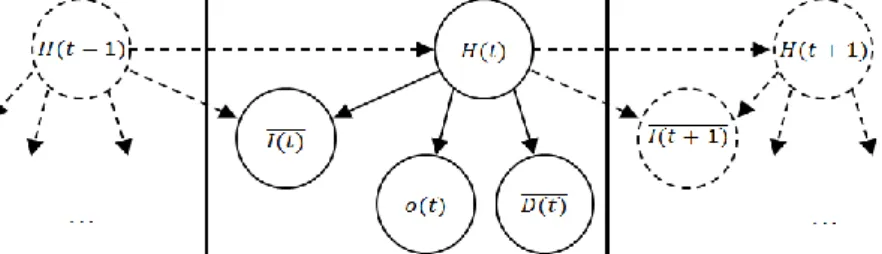
It has to be reminded that random variable ( ) ( * +) is defined to represent the real user location over time.
Fig. 3. Dynamic Bayesian network structure
4.2 Stage 2: applying Bayesian estimation to enhance localization estimates
Sensors estimations are fused using a recursive Bayesian filter (RBF). The RBF is a general probabilistic technique to recursively estimate an unknown state using incoming measurements [25]. In our particular problem, ( ) is the unknown state and
( ) ( )̅̅̅̅̅̅̅ and ( )̅̅̅̅̅ are the incoming measurements.
Being ( )̅̅̅̅̅ [ ( ) ( )̅̅̅̅̅̅ ( )̅̅̅̅̅] and ( )̅̅̅̅̅̅ [ ( )̅̅̅̅̅ ( )̅̅̅̅̅̅̅̅̅̅̅ ( )̅̅̅̅̅̅] respectively the whole set of measurements in t and the whole set of measurements since the system is started, the improved location estimation ( ( )̂) can be determined by calculating the area (argument k) that maximizes the probability of being there when taking into account the sensing history:
( )̂ [ ( ( ) ( )̅̅̅̅̅̅)] (1)
In order to be able to develop (1), it is necessary to consider that: temporal transitions between states follows a Markovian evolution;
for localization and proximity events, the measurements observed at a time are independent from previous states (see causal relations in Figure 3‘s DBN); for transition sensors, the measurements observed at a time depend on the state
in that particular instant but on the previous instant too (see causal relations in Figure 3‘s DBN).
Then, having into account that:
( ( ) ( )̅̅̅̅̅̅) ( ( ) ( )̅̅̅̅̅̅̅̅̅̅̅ ( )̅̅̅̅̅) (2) and applying Bayes theorem to (2):
( ( ) ( )̅̅̅̅̅̅) ( ( )̅̅̅̅̅ ( )̅̅̅̅̅̅̅̅̅̅̅ ( )) ( ( ) ( )̅̅̅̅̅̅̅̅̅̅̅)
( ( )̅̅̅̅̅ ( )̅̅̅̅̅̅̅̅̅̅̅) (3)
The first term in the numerator of equation (3) corresponds to the sensors‘ event models, existing some differences between proximity and transition sensors:
for proximity binary sensors, as they are independent over time:
( ( )̅̅̅̅̅| ( )̅̅̅̅̅̅̅̅̅̅̅ ( )) ∑ * ( ( )̅̅̅̅̅| ( ) ( )) ( ( )| ( )̅̅̅̅̅̅̅̅̅̅̅)+
(3.1b)
According to the DBN structure, the second term in equation (3) can be also developed as:
( ( )| ( )̅̅̅̅̅̅̅̅̅̅̅) ∑[ ( ( ) ( )) ( ( )| ( )̅̅̅̅̅̅̅̅̅̅̅)]
(3.2)
Summarizing, the RBF algorithm requires defining 1) a probabilistic model for every kind of sensor and 2) a probabilistic user transition model representing possible movements between zones. Following, the implications of this need are explained.
4.3 Sensor model
RBF algorithm requires having the sensors modelled as stated in equations (3.1). Regarding proximity sensors, equation (3.1a) probabilistically relates the sensor estimation ( ( ) ( ) * +) to the real area where the user is placed ( ( )). However, the proximity binary sensors are modelled as defined in Section 3.2. These two expressions can be related as follows:
( ( )| ( )) ∑ [ ( ( ) ( ) ) ( ( ) | ( ))]
* +
(4)
So it is necessary to model ( ( ) ( )) in order to be able to apply RBF algorithm. That means that we need to know certain a priori user behaviours patterns (i.e., how often is the user in the coverage of each sensor, knowing that he/she is in a particular area). In this very first implementation, this issue is approached having into account the sensors‘ coverage, so ( ( ) ( ))
. Each sensor is also supposed to just have coverage in only one area. For the localization system and the transition sensors the same reasoning may be applied. In these cases quality models presented in Sections 3.1 and 3.3 perfectly fits in the RBF algorithm, not requiring extra information about user behavioural patterns.
4.4 Transition model
RBF algorithm also requires having a transition model (determined by
( ( ) ( )). As a simple approach to model the transition, our transition model now only states impossible transitions, depending on the physical map of the environment, and equidistributes the possible ones (i.e., the probability of staying in a particular area is the same as transiting to any of the areas with direct access).
5 Simulation results
real detection error rates both for proximity sensors (only those based on motes) and for the localization system. However, transition sensors‘ quality has not been empirically estimated yet, so its influence over the algorithm output has been evaluated for different ranges of qualities.
5.1 Analysing the effects of the sensor deployment strategies
In order to roughly determine the overall capabilities of the improvement algorithm some preliminary simulation tests have been run. Table 1 shows the simulation parameters and Figure 4 the results. Areas distribution, location system and proximity sensors characteristic have been modelled according real laboratory conditions and measurements; however, for these simulations, location of each proximity and transition sensors is randomly settled. This process is repeated several times in order to obtain average results.
These preliminary tests will help in evaluating how the number of proximity and transition sensors and the features (quality) of the transition sensors may affect the location improvement algorithm output.
Table 1. Preliminary simulation tests parameters
Transition model { ( ( ) ( ))
Location system quality Real data from a WSN-based location system (proximity-based) Experimental average hit rate = 71.21%
# proximity sensors From 1 to 46 (1 sensor Randomly allocated (in each scenario) → only 1 area of coverage)
Proximity sensors quality
Every sensor modelled as low powered motes proximity sensors
Experimental sensor quality: { ( ( ( ) ( ) ( ) ) ( ) )
# transition sensors From 1 to 12 (maximum according real area distribution, Figure 1) Randomly allocated (in each scenario)
Transition sensors quality Ranging from 90 to 100% in positive hit rate [100% in negative hit rate]
# random scenarios = 1,000 # trajectories per scenario = 1,000 # transitions per trajectory = 1,000
Figure 4.a depicts the hit rate depending on the number of proximity sensors, showing also the introduced improvement with respect to the location system quality. The improvement introduced by the Bayesian algorithm reaches 99.0, 99.5 and 99.9 hit rate % with 48, 58 and 87 proximity sensors respectively. Considering the real scenario presented in Figure 1, using 11 proximity sensors would lead to 89.96% of hit rate and an improvement of +18.75% with respect to the original location system quality.
It can be noticed that with no sensors the improvement algorithm obtains around 78.35% of hits; this improvement (~ +7%) is due to the transition model effects that corrects impossible transitions estimated by the location system.
transition sensors of lower quality than around 85%. This issue must be taken into account when developing real binary transition sensors.
Fig. 4. a) Proximity and b) transition sensors influence over location estimation
5.2 Evaluation of the Bayesian location improvement algorithm in a real scenario
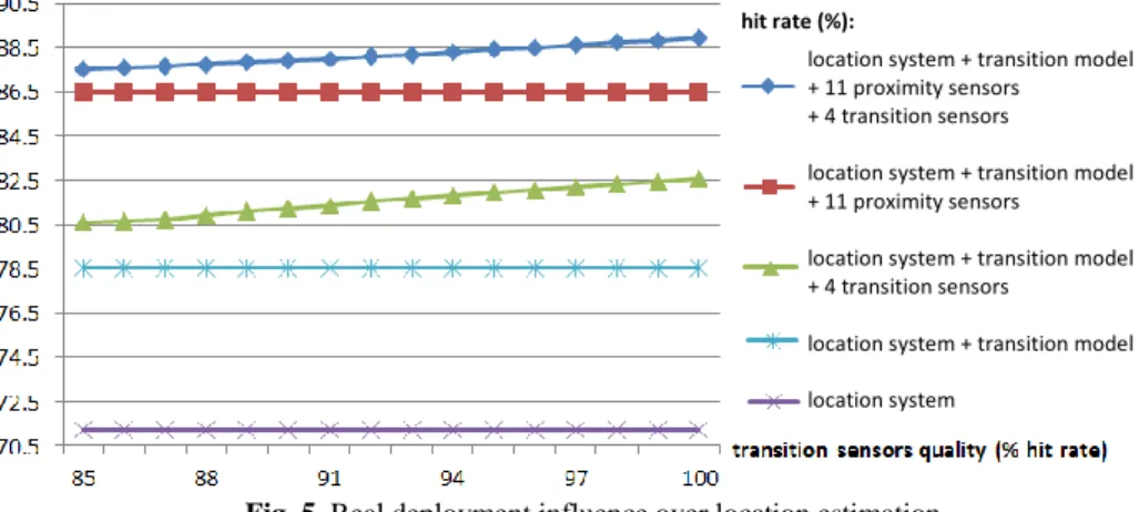
Finally, in Figure 5 the results of a simulation employing together both proximity and transition sensors are presented. This test has been set to be run using our real deployment configuration (Figure 1). The number of proximity sensors has been set to 11 for this simulation (matching the number of sensors nowadays available for our real deployment). Only 4 transition sensors have been employed, placed in the ‘crossroads’ of areas 3, 4, 5 and 6. These four areas share a common transition zone, so it was decided to place there several transition sensors, trying to reduce location system errors. As we are still working in the configuration of the transition sensors, the obtained improvement is shown over several transition sensors qualities.
Fig. 5. Real deployment influence over location estimation
When only using 11 proximity sensors to enhance the location system (no transition sensors), an improvement of +15.29% is obtained (86.5% of global hit rate) being these results slightly lower than in the previous test (Figure 4.a). The fact that in the tests of previous subsection sensors are randomly placed over any of the areas may have influenced these results. It has to be noticed that in Figure 5 results, all the 11 proximity sensors are placed in only four of the total seven areas available. The same effect applies to the transition sensors.
location system + transition model + 11 proximity sensors
+ 4 transition sensors
location system + transition model + 11 proximity sensors
location system + transition model + 4 transition sensors
location system + transition model
6 Discussion and further work
In this paper we have proposed a probabilistic Bayesian-based model to be applied to an already deployed location system in order to enhance its quality by means of adding new information coming from low-cost binary sensors, thus taking advantage of the localization capabilities of different technologies usually present in smart environments (programmable mote-based WSN nodes, RFID tags and readers, etc.). The set of sensors used (location system and proximity / transition binary sensors) and its relations are also probabilistically modelled. The performance of the proposed algorithm over a real sensor deployment is evaluated simulating the enhancement mechanism using real experimental data (specifically regarding location system and proximity sensors events model).
Several simulations have been performed, taking into account random binary sensors deployment but also a fixed one based on the particular resources available in our laboratory. For the fixed deployment, these simulations offer improvements in location hit rate ranging from around +16.3% and +17.7% (depending on specific sensors qualities), increasing location system quality from a 71.21% of hit rate to around 88%. These simulations are also a good starting point for quantifying and qualifying future real implementations of this improvement mechanism. In this sense, simulations performed in a fixed deployment should be extended in order to further analyse the influence of particular placements of binary sensors. The results regarding transition sensors have also to be taken into account when actually configuring these kinds of sensors.
The improvement mechanism also can be further enhanced. For example, currently it is assumed that the location system generates a deterministic estimate but it may be generalized to allow the use of a probability distribution.
We are working on a real implementation of this mechanism, which would require 1) to actually configure a set of transition binary sensors, 2) to probabilistically model different transition and proximity sensors (i.e., RFID-based) and 3) to design the infrastructure processing the data coming from the different sensors.
Having all these issues in mind, a real implementation of these improvement mechanisms appears to be quite promising.
Acknowledgments. This work has been supported by the Government of Madrid under grant S2009/TIC-1485 (CONTEXTS) and by the Spanish Ministry of Science and Innovation under grant TIN2008-06742-C02-01.
References
1. T. Teixeira, G. Dublon, A. Savvides, ―A Survey of Human Sensing: Methods for Detecting Presence, Count, Location, Track and Identity,‖ ACM Computing Surveys, 2010.
2. E.F. Nakamura, A.A.F. Loureiro, A.C. Frery, ―Information fusion for wireless sensor networks,‖ ACM Computing Surveys, vol. 39, nº. 3, pp. 9-es, 2007.
3. X. Li, ―RSS-based location estimation with unknown pathloss model,‖ IEEE Transactions on Wireless Communications, vol. 5, issue 12, pp 3626-3633, Dec. 2006.
5. P. Bahl, V.N. Padmanabhan, ―RADAR: an in-building RF-based user location and tracking system,‖ in Proc. IEEE Infocom, pp. 775-784, March 2000.
6. K. Lorincz, M. Welsh, ―Motetrack: a robust, decentralized approach to RF-based location tracking,‖ Int. Workshop on Location and Context-Awareness at Pervasive, May 2005. 7. H. Martín, P. Tarrío, A.M. Bernardos, J.R. Casar, ―Experimental Evaluation of Channel
Modelling and Fingerprinting Localization Techniques for Sensor Networks,‖ in International Symposium on Distributed Computing and Artificial Intelligence 2008 (DCAI 2008), vol. 50, Springer Berlin / Heidelberg, 2009, pp 748-756.
8. P. Bahl, V.N. Padmanabhan, ―Radar: An in-building rf-based user location and tracking system,‖ In INFOCOM, 2000.
9. G. Giorgetti, S. K. Gupta, G. Manes, ―Wireless localization using self-organising maps,‖ In IPSN, 2007.
10.T. He, C. Huang, B.M. Bium, J.A. Stankovic, T. Abdelzaher, ―Range-free localization schemes for large scale sensor networks,‖ In ACM MobiCom‘03, 2003.
11.T.Wark, C. Crossman, W. Hu, Y. Guo, P. Valencia, P. Sikka, P. Corke, C. Lee, J. Henshall, J. O‘Grady, M. Reed, A. Fisher, ―The design and evaluation of a mobile sensor actuator network for autonomous animal control,‖ In IPSN, pages 206–215, 2007.
12.V.A. Kaseva, M. Kohvakka, M. Kuorilehto, M. Hännikäinen, T.D. Hämäläinen, ―A Wireless Sensor Network for RF-Based Indoor Localization,‖ EURASIP Journal on Advances in Signal Processing, vol. 2008, Article ID 731835, 27 pp, 2008. doi:10.1155/2008/731835 13.J. Zhou y J. Shi, ―RFID localization algorithms and applications—a review,‖ Journal of
Intelligent Manufacturing, vol. 20, nº. 6, pp 695-707, 2008.
14.Z. Wang, E. Bulut, B.K. Szymanski, ―A distributed cooperative target tracking with binary sensor networks,‖ Proc. IEEE International Conference on Communication (ICC) Workshops, May 2008, Beijing, China, pp. 306-310.
15.Z. Wang, E. Bulut, B.K. Szymanski, ―Distributed Target Tracking with Imperfect Binary Sensor Networks,‖ Proc. IEEE Global Communications Conference (Globecom), December, 2008, New Orleans, USA, pp. 1-5.
16.Z. Wang, E. Bulut, B. Szymanski, ―Distributed Target Tracking with Directional Binary Sensor Networks,‖ in Global Telecommunications Conferece. GLOBECOM. 2009.
17.H. Wymeersch, J. Lien, M. Win, ―Cooperative Localization in Wireless Networks,‖ Proceedings of the IEEE, vol. 97, nº. 2, pp 427-450, 2009.
18.P. Castro, P. Chiu, T. Kremenek, R. Muntz, ―A probabilistic room location service for wireless networked environments,‖ In Proceedings of Ubicomp‘01, October 2001.
19.D.H. Wilson. ―People Tracking Using Anonymous, Binary Sensors,‖ M.S. Thesis, CMU Center for Automated Learning & Discovery, 2003.
20.A. Ladd, K. Bekris, A. Rudys, D. Wallach, L. Kavraki, ―On the feasibility of using wireless ethernet for indoor localization,‖ Robotics and Automation, IEEE Transactions on, vol. 20, nº. 3, pp 555-559, 2004.
21.D. Joho, C. Plagemann, W. Burgard, ―Modeling RFID signal strength and tag detection for localization and mapping,‖ in Robotics and Automation, 2009. ICRA '09. IEEE International Conference on, pp 3160-3165, 2009.
22.S. Jia, J. Sheng, K. Takase, ―Improvement of performance of localization ID tag using multi-antenna RFID system,‖ in SICE Annual Conference, 2008, pp 1715-1718, 2008.
23.L. Klingbeil y T. Wark, ―A Wireless Sensor Network for Real-Time Indoor Localisation and Motion Monitoring,‖ in 2008 International Conference on Information Processing in Sensor Networks (IPSN 2008), pp 39-50, 2008.
24.H. Martin, E. Metola, L. Bergesio, A.M. Bernardos, J. Iglesias, J.R. Casar, ―An RFID-enabled framework to support Ambient Home Care Services,‖ Third International EURASIP Workshop on RFID Technology, 2010. Cartagena, Spain.
![Fig. 1. Technological scenario in our laboratory (adapted from [24]).](https://thumb-us.123doks.com/thumbv2/123dok_es/6749625.828664/4.892.188.709.730.976/fig-technological-scenario-laboratory-adapted.webp)