Relation between structure and morphology in the
development of the granite cave of "O Folón"
(Vigo, Galicia-Spain)
Relación entre estructura y morfología en el desarrollo de
la cueva granítica de "O Folón" (Vigo, Galicia-España)
VAQUEIRO RODRÍGUEZ, M.1, BARREIRO BEN, B 1, COSTAS VÁZQUEZ, R.1, SUÁREZ PÉREZ, R.1and GROBA GONZÁLEZ, X.1
Abstract
O Folón is a subterranean pseudokarstic system developed in granites. The cavity has been develo-ped in several stages dynamised by the active eustatic changes of the end of the Caenozoic in the wes-tern coast of Galicia, NW Spain. The system evolution starts with the subedaphic weathering of the rock through the discontinuities. The water circulation by the fissural system produces the emptying of alterite that infilled it. This process firstly begins in the superficial zone of the massif while the weathering continues in the lower levels. The appearance of voids among blocks allows its resetting. Outside this produces exo pseudokarstic forms (doline type) and inside collapse forms (chaos de bou-les) infilling the voids. The charge concentration on the contact points among blocks generates sca-llops, pressure scales or onglets. At first, the water flow at low velocities allows the generation of rills or the deposit of speleothems, essentially flowstone, bell canopy and varved deposits. As water flow increases its speed, there appear forms of mechanical erosion (pot-holes). The relative unevenness of the subterranean system, 34 m, is close the one of the change in the base level of the zone, 60 m. The difference is due to the scarce capacity of the waterflow that drains by the O Folón system to erode the rock. 905 m of galleries and passages, mainly fossil conduits, were mapped including 235 m of active subterranean flow. The development of the cavity is adapted to the massif fracture systems with two main orientations: subvertical diaclases and subhorizontal shear planes. The morphology of the conduits is of phreatic and vadose type with transition forms among them, very similar to the ones described for carbonate rocks. The use of complex projections, plant detail, longitudinal profiles and cross-sections allows the reconstruction of the cavity evolution during the network incision. The cross-sections have been elongated vertically up to the external geomorphologic surfaces close to O Folón, thus enabling to associate the evolution of the cave with the regional geomorphologic history.
Key words:pseudokarst, granites, mechanical erosion, edaphic weathering, speleothems, vadose and phreatic circulation, base level.
INTRODUCTION
O Folón Cave, located in the village of Fragoselo-Coruxo, council of Vigo (Galicia, Spain) (Fig.1a) [UTM: 519939E, 4670444N], is a pseudokarstic granite system boulder cave related to Late-Hercynian fracture. Tubes and pipes appear to be formed by ero-sion carried out by water of the materials derived from the rock weathering (VAQUEI-RO, 2003). Table 1 summarizes the main topographic data for this cave.
The cave system was developed by the continued incision of the da Rega River from the surface +100/+120 m.a.s.l of Plio-Pleistocene geomorphologic age (VIDAL ROMANÍ, 2002) (Fig. 1b).
Like in karstic systems s.s. (VENI, 2005), in the granitic massifs the pseudokarstic systems are developed according to factures and diaclased planes where permeability is gre-ater. These planes and fractures guide the deve-lopment and evolution of the conduit network of O Folón as the base level is modified. The
Fig. 1a
Fig.1. Location maps for the area that are being studied. To the right canyon detail and fracture sets which have determined the O Folon System Cave structure and the pattern of passages. The system is being deve-loped by the recursive cutdawn of the river Río da Rega which had started from the paleo-surface of +100 m.a.s.l. / +120 m.a.s.l.
Fig. 1b
enlargement of the fracture network allows the opening of voids each time greater and at grea-ter depth in the rocky massif. The big mechani-cal resistance of the granites (> 1500 kg/cm2) enables the development of big vaults though with smaller heights than in limestone. With certain dimensions, depending on the rock resistance, the collapse of the conduits is pro-duced with accumulation of blocks generated in the lower spaces. In surface the movement of blocks will give rise to subsidence doline.
In the granites the dissolution does not control the process like in karstic zones s.s., and the lateral migration of the subterraneous rivers in the regolith free conduits is essen-tially produced by physical erosion. The capa-city of these processes is less than in the karst of soluble rocks due to the greater resistance of the rock and its insolubility. But it is also pos-sible to establish a geomorphologic sequence to reconstruct the process with certain detail.
As indicated above, weathering in granitic rocky massifs only developed when a varia-tion in the base level is produced. In O Folón, its closeness to the general base level (coastli-ne) enables to relate its evolution with the one of the Vigo Ría during the same time stage. The process develops at about the beginning of the Cainozoic, though especially during the Quaternary, due to the eustatic changes related to the glacial and interglacial stages of the Pleistocene. The incision associated to the changes of the base level, however, is closely adapted to the massif structure (essentially formed by a system of horizontal and vertical or subvertical planes). Therefore, the longitu-dinal profile of the O Folón pseudokarstic
system is represented by a succession of rocky steps over which the present network flows (VIDAL ROMANI, 2002).
In O Folón there are distinguished four big granitic steps which are, from top to wall, the following: The Absorption-Central Doline area, the Central Dolinearea, the Cascade Pit -X.Xebas Sump area, and the X.Xebas Sump-Springarea.
The circulation of the da Rega River, which drains through O Folón in its present subterra-nean section, presents very variable features. In the present channel the abandoned inactive sec-tions alternate with other partially infilled by moved blocks and with still active sections. In case of the fossil or abandoned sections it would be difficult to reconstruct the original outline if there were not preserved forms like pot-holes and fossil micro-channels, or varved deposit infillings and other sedimentary forms typical of endokarstic environments.
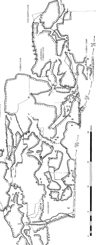
In this work there are described the featu-res of the pfeatu-resent flow and of the paleo-chan-nels located between the Central Doline and the sump of X.Xebas (Fig. 1c).
This section has been selected due to two reasons:
- The cave conduits are narrow and verti-cal, preferably enlarged along the sub-vertical pseudo-foliation developed after the shear band.
- The accessible conduits of this sector have been relatively preserved intact in an wide zone located between the surfa-ce and the local sump (from -10 to -23/-25 m with respect to the Absorption area).
SYMBOLOGY AND REFERENCES
There is not an adequate legend that repre-sents the granitic forms and even less in the case of subterranean environments. To solve this, an adaptation of the existing nomenclatu-re is proposed in this work and, when neces-sary, there was made a proposal of new symbols. The nomenclature used herein is based on four types of legends:
- Cave symbols, edition 1999, from the official UIS Symbol List, by Survey and Mapping Working Group, UIS Informatics Commission at the International Union of Speleology. (They can be found in one of these web pages: http://www.uisic.uis-speleo.org/wgsurmap.html#symbols or http://www.carto.net/neumann/caving/ cave-symbols/ ).
- Cave symbols list, edition 1992, from the official FEE Symbol List. (MARTÍNEZ I RIUS, 1992)
- Geomorphologic symbols for the "Mapa geomorfológico de España" (MARTIN-SERRANO et al., 2004).
- New symbols designed for this work: some "official" symbols have been used, extending their meaning. In these cases the new meaning for the symbol was detailed in italics.
Table 2 contains the list of used symbols. In the topographic works of cavities, the symbols of plan and profile could vary but in general the geomorphologic symbols are the same in both cases.
The height of the steps and the depth of the pits are indicated in centimetres, avoiding decimals.
The topographic data given by the Clube Expeleolóxico Maúxo have been compiled between 1992 and 2006 and they were: First version 1992-1997 (CEM, 1997, 1998); second version, reviewed and redesigned (GROBA et al., 2002 a and b); third version that includes the second doline and the sump-spring area (VAQUEIRO, 2004); and the final
geomorphologic topography including com-plete cross-sections, surface channels and spe-cial profiles (VAQUEIRO, 2006).
The cartography presented herein enables to correlate present and fossil forms and gra-phically represent the genesis and evolution of the subterranean system of O Folón in a sim-ple manner.
Archaeological levels have been used as chronological reference and also to indicate accessibility to the cave during prehistoric times. Nevertheless, the exact location of archaeological sites is not indicated to protect them from sacking.
CHARACTERISTICS OF THE CON-DUITS
boul-ders among them or against the conduit walls. In some cases several superposed sections of galleries may appear confirming the network incision caused by changes in the base level.
Figures 2a and 2b represent a series of cross-sections of conduits of the studied zone. There the morphologic features aforementio-ned are indicated: lateral notches, paleo-chan-nels, pot-holes and other forms of mechanical erosion and formation of speleothems.
The only waterfall existing in O Folón is developed in the intersection of two fractures with directions N30ºE and N160ºE (VAQUEI-RO, 2003). The lateral vadose conduits in the
upper part of the "Cascade Pit"may be inter-preted as an abandoned anastomased channel when the water enlarged the pit after cutting down the surface of the upper conduit. Water has excavated there a subvertical incise gutter in the surface over which it flows. It is a plane with orientation 75º N 270E.
In this zone the erosion forms are located between -10 and -15 m below the Absorption area. Paleo-levels have been mainly identified based on the lateral notches at the bottom of the channel and pot-holes tilted by the block movement where they developed or simply by remains of pot-hole.
Fig. 2a
Fig. 2b
The vadose conduits have notches on their bottom that use the existence of horizontal discontinuities. Its profile is asymmetric which may be due to structural reasons (diffe-rent orientations of the discontinuities). These notches have rough surface which may be due to either a short water circulation along them
or a later weathering. They have been repre-sented in figures 3a and 3b.
Figures 3c and 3d correspond to complex profiles formed by the coalescence of diffe-rent undercutting fronts transversal to the channel development. They are located bet-ween levels L2 and L3.
Fig. 3b
Fig. 3c Fig. 3d
Fig. 3. Many different notches and their relation to structural fractures. They have been located in paleo-levels. Note that subhorizontal notches are not symmetrical.
Fig. 4b Fig. 4c
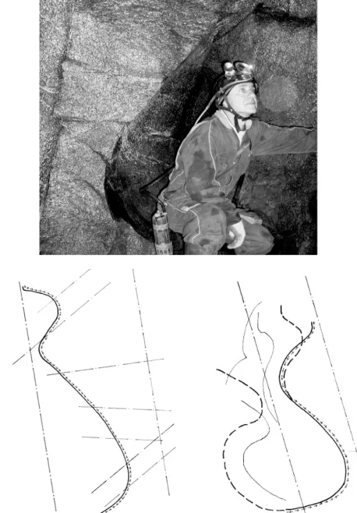
Fig. 4. A cross section of an incised passage developed under phreatic conditions. At present passage is par-tially collapsed and removed. It permits us the measure of diagonal and dipping fractures. The conduct have been reconstructed from disarticulated fragments.
In the picture, a part of this phreatic-incised conduct can be seen beyond the caver.
Fig. 5a
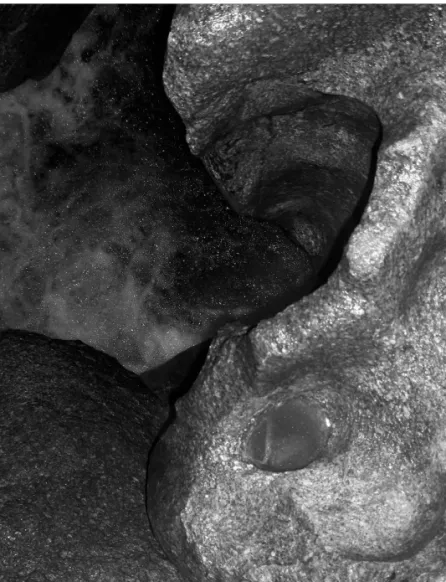
Fig. 5. To the left, many onglets have been developed along the subhorizontal limit between corestones in the transition from the L2/L3 paleo-levels to L4. These forms appear to be like scallops (pure erosional form in vadose passages), but they derive from local structu-ral overloads which produce rock weathering.
When vadose or phreatic passa-ge is developed, the weathered rock is removed by water flow. The form is pulished during vadose evolution of the passage. Below, many vadose conducts including potholes and other erosional forms from level L4. The picture at the center is the rockslide which collapsed the stepped transititon between L3 and L4 levels. The collapse have developed the ending sump area in this cave.
Fig. 6b
Fig. 6c
In the transition from paleo-level L2/l3 to level L4, some onglets or pressure scales (fig. 5a) have been developed on the border of the big blocks that form the walls of the main flow. These onglets or pressure scales are con-vex forms developed by charge concentration on the contact points between moved blocks and the cavity walls or even in other blocks.
Some conduits present elliptical or circu-lar sections (fig. 4a). Generally, the ellipses are of oblique axis with elongation according to the subvertical shear plane 75º N270ºE (Y-plane), though they may be influenced by other subhorizontal discontinuities (0, +/-10, +/-20º) (fig. 4b). The walls of these conduits are polished and in some cases are symmetric with respect to the fault plane. One of these conduits is represented in figure 4c.
These conduits have complex sections for-med by interference of several elliptical tubes of different dimensions. The resulting forms do not coincide with the "keyhole" sections (incised phreatic conduits) typical of the karst, but the existence of elliptical sections seems to indicate that each level in these conduits has been initially developed under phreatic conditions.
Figures 6a, 6b and 6c correspond to three complex sections. The first shows the present structure of the system below the Central Doline (collapsed structure). Its upper line highlights the limits of the doline and is used as reference for the other two. The second sec-tion (fig. 6b) corresponds to the waterfall drai-nage divide. The maximum water level at pre-sent is reprepre-sented by the dotted line with the flow symbol. There are indicated the dipping of planes and factures where the lateral not-ches and the waterfall channel incision start from. The third section (fig. 6c) has been cons-tructed by superposition of several individual sections where the blocks have gone back to their theoretical original position trying to so reconstruct the disposition of the rocky wall at that moment. In the old conduits it is marked the lateral notch that limits the vadose and
incise channel. The pressure scales, complete pot-holes or their fragments are marked in their corresponding position and at their real elevation.
DISCUSSION
The da Rega River is a secondary course of the network that drains through the Vigo Ría.
As the sea level changed during the Plio-Pleistocene, the phreatic level goes down to lower levels and increases the hydraulic gra-dient. This produced the change in the water cir-culation regime through the system of conduits from phreatic to vadose and finally the incision of the channel bottom.
This incision process successively left hanging the older levels of the system genera-ting new ones and modifying the hydraulic gradient and, therefore, the erosion capacity of the water.
As the walls of the conduits were eroded and lateral notches were produced, the new surfaces interfered with other fractures of the system. One consequence of this erosive pro-cess is the release of the block system through which the system of conduits flows, fragmen-ting or even destroying them completely making it lose its capacity of water flow which had to look for another way. In some cases the blocks even moved hid the original morphology of the conduit (fig 5b).
Fig. 7. Cave profile from the studied area.
This profile is not a planar plot of cave passages. Passages have been projected ov
er the Riedel planes which
deter-mine the cave pattern. It can be observed the present structure of this system between the Central Doline and the X.Xebas Sump.
The water carry at the
pre-sent is remarked with flow marks.
They are indicated lateral notches, potholes and disarticulated potholes, weathering forms an
d speleothemes in their real
Fig. 9. A detail of a pothole developed between L3 and L4 flow levels. The three-dimensional perspective of the
zone (fig. 8) shows the relative disposition of the phreatic and vadose conduits and allows the reconstruction of the evolution of the sub-terranean incision.
The phreatic conduits are located in section S3 hanging over the main vadose conduit. They are very close to the intersection between the upper subhorizontal levels (L1-L2) and the intermediate paleo-levels with incision (L2-L3). They may be interpreted as the result of
the flow capture that drained through the pseu-do-phreatic conduits. This would indicate that the paleo-levels were not static but dynamic without simple transition among them.
This view has been made from different cross-sections from which the blocks have been eliminated virtually to show the continuous rock walls only. The paleo-flows (paleo-levels), erosion forms, speleothems and rocks-lides have been indicated with their real levels. Note that in this projection the relation among the horizontal, oblique and vertical axes is (1, fi, 1). The equidistance used to form the surfa-ces has been of 1 m.
CONCLUSIONS
The development patterns of the conduits in the granitic caves are directly related to the local structure system. The distribution and the geometry of the conduits inside the system depend on the lithology, structure and regime of the water flow through the systems of cavities.
Generally, these conduits present a cross-section of incise channel with development
related to the subvertical fracture planes and the subhorizontal shear bands. The fracturing den-sity of the massif determines the development and evolution of the conduits and facilitates the collapse of the conduits and the related accu-mulation of smaller blocks and fragments in the available space.
The structures of phreatic-incise and vado-se origin, their evolution by continuous inci-sion, as well as the capture processes (flow piracy) are quite similar to the equivalents in the karstic systems s.s..
ACKNOWLEDGEMENTS
We thank Ana Martelli for reviewing the paper English version and Juan Ramón Vidal for his criticism of the ideas expressed in this paper which helped to improve it. The work and surveys would not have been done without the help of friends in the "Clube Espeleolóxico Maúxo" - Speleological Association.
BIBLIOGRAPHY
CLUBE ESPELEOLÓXICO MAÚXO (1997). Campaña topográfica de O Folón (1992-1997). Memoria y Cartografía. Archivos CEM. Clube Espelelóxico Maúxo. Vigo, Pontevedra.
CLUBE ESPELEOLÓXICO MAÚXO (1998). Cartografía Arqueológica de O Folón. Archivos CEM. Clube Espelelóxico Maúxo. Vigo, Pontevedra.
GROBA GONZÁLEZ, X. and VAQUEI-RO VAQUEI-RODRÍGUEZ, M. (2002). Catálogo de Cavidades Gallegas del No-Karst y PseudoKarst clasificadas genéticamente. 1992-2002. Archivos CEM. Diciembre 2002 . Clube Espelelóxico Maúxo. Vigo, Pontevedra.
GROBA GONZÁLEZ, X. and VAQUEI-RO VAQUEI-RODRÍGUEZ, M. (2002). El sistema gra-nítico de O Folón. Memoria de investigación y topografía 1992-2002. Archivos CEM. Diciembre 2002. Clube Espelelóxico Maúxo. Vigo, Pontevedra.
HILL C. and FORTI P. (2005). Cave mine-rals of the world. National Speleological Society, Huntsville, AL.
LUNDBERG, J. (2005). Karren. Encyclopedia of Caves (David C.Culver & William B. White): Elsevier, pp: 315-321.
MARTÍN-SERRANO, A.; SALAZAR, A.; NOZAL, F. and SUÁREZ, A. (2004). Mapa Geomorfológico de España a Escala 1:50.000. Guía para su elaboración. Instituto Geológico y Minero de España. Madrid.
MARTÍNEZ I RIUS (1992). Topografía Espeleológica. Federación Española de Espeleología. Badalona.
PALMER, A.N. (2005). Passage growth and development. Encyclopedia of Caves
(David C.Culver & William B. White): Elsevier, pp: 440-444.
TWIDALE C. R. and VIDAL ROMANÍ J. R. (2005) - Landforms and geology of granite terrains. A.A. Balkema Publishers Leiden. Great Britain.
URBANI, F. (2002). Venezuelan Cave Minerals: A review. Universidad Central de Venezuela, Escuela de Geología, Minas y Geofísica, Caracas 1053 & Sociedad Venezolana de Espeleología, Caracas 1041ª, Venezuela.
VAQUEIRO RODRÍGUEZ, M. (2003). Caracterización de cavidades de bloques graní-ticos y cuevas estructurales de Vigo-Tui, (Galicia, España). Análisis morfoestructural del sistema de O Folón. Cadernos Laboratorio Xeolóxico de Laxe. Vol. 28, pp. 231-262.
VAQUEIRO RODRÍGUEZ, M. (2004). Cartografía del sistema granítico de O Folón 1992-2002, 2002-2004. Archivos CEM. Agosto 2004. Clube Espelelóxico Maúxo. Vigo, Pontevedra.
VAQUEIRO RODRÍGUEZ, M. (2006). Cartografía geomorfológica del sistema graní-tico de O Folón 1992-2006. Archivos CEM. Mayo 2006. Clube Espelelóxico Maúxo. Vigo, Pontevedra.
VENI, G. (2005). Passages. Encyclopedia of Caves (David C. Culver & William B. White): Elsevier, pp:436-440.
VIDAL ROMANÍ, J. R. (2002). El relieve actual de Galicia in Historia Natural: Geologia, Tomo 36, pp. 304-341. Hercules de Ediciones S.A. A Coruña.