Management and Innovation for a Sustainable Built Environment ISBN: 9789052693958 20 – 23 June 2011, Amsterdam, The Netherlands
SUSTAINABLE PLANNING AND LAND VALUATION. NEW FORMS OF SUBURBAN GROWTH IN AREAS OF THE SPANISH MEDITERRANEAN COAST
GEMA RAMIREZ PACHECO Universidad Alicante, Espana [email protected] FEDERICO GARCIA ERVITI Universidad Politecnica Madrid, Espana [email protected]
Abstract
The present study analyzes residential models in coastal areas with large influxes of tourism, the sustainability of their planning and its repercussion on urban values. The project seeks to establish a methodology for territorial valuation through the analysis of externalities that have influenced urban growth and its impact on the formation of residential real estate values.
This will make it possible to create a map for qualitative land valuation, resulting from a combination of environmental, landscape, social and productive valuations. This in turn will establish a reference value for each of the areas in question, as well as their spatial interrelations. These values become guidelines for the study of different territorial scenarios, which help improve the sustainable territorial planning process.
This is a rating scale for urban planning. The results allow us to establish how the specific characteristics of the coast are valued and how they can be incorporated into sustainable development policies.
Keywords: territorial valuation; sustainable planning; suburban growth
INTRODUCTION. CURRENT SITUATION
The urban territorial structure of developed countries has changed significantly over the past several decades, due to service sector expansion, transportation improvements (Leinfelder,2007) and population growth, prompting the regeneration and planning of suburbia, which goes beyond a territorial transformation as it also involves social, political and economic changes. These transformations have made the regeneration and planning of ample suburban fabrics necessary, and have provoked a profound territorial, social, political and economic transformation.
The discourse about the meaning of city and countryside is not unique for all the countries. The European RURBAN-project conclusions (Overbeek, 2006) indicate a dominant planning discourse. This sets that city and countryside are two separate entities that need a complementary and simultaneously opposite policy: new developments are concentrated in urban areas, while the open space is safeguarded against new developments.
On a territorial level, these changes have caused the classic appraisal models for urban value to lose validity. In this context, how are the countryside and the city valued?
highly valued as a space for production and consumption and the city and urbanisation are perceived in a more negative way. In contrast, the Mediterranean rural tradition approaches the countryside negatively and perceives city and urbanisation quite positively because it stimulates economic development.
However the traditional political dichotomy in simple categories ‘city’ and ‘countryside’ is being questioned increasingly. It ignores the complexity and stratification of society (Halfacree, 2004). The relations between places and activities have become very complex in network society and concern different spatial scales at the same time (Leinfelder, 2007).
Most of development possibilities are in open space where there are now areas of environmental interest. This stance has led to the devaluation of the environmental potential of many areas of the Spain’s Mediterranean coast due to the intense pressure of the tourism industry. In these locations, the significant increase in residential land has contributed to a gradual loss of the territory’s environmental values. The main problem is that the economy of these areas is based on tourism linked to environmental values. The primary purpose of encouraging the preservation of environmental values may not be financial, but financial justification for these actions is nearly always required (Crompton, 2007)Therefore there is a contradictory situation and it is remarkable how planning has not taken clear role for open space in ‘network urbanity’ (Leinfelder, 2007).
Currently, land value responds to more than just accessibility factors and urban hierarchical structuring. It is also defined by its capacity to support marketable real estate products and the market value of said goods. This market value is determined by a set of qualities or attributes that cannot be traded independently, but rather only as an integrated market unit. The group of variables that affects each choice has a direct impact on the property appraisal process (Kauko, 2008). Its analysis is fundamental to understanding the complex system of urban development and growth.
Given this scenario, it seems particularly relevant to develop innovative methodologies that specify tools and techniques capable of meeting developmental and land management requirements on a regional and local scale. The offer has a spatial location, which must be considered for the market analysis (Gutiérrez and Gould, 1994).
The main goal of this study is to rehearse new techniques for sustainable development planning using technological applications. The analysis of externalities that have had an influence on urban growth and the appraisal of residential real estate products will help establish a methodology for land valuation.
The work creates different outlines for urban valuation. The result is approximate to an economic valuation on a territorial scale. It analyzes the impact of the urban and natural attributes that make a city attractive. This analysis is supported by economic, social, environmental and urban planning concepts, and is used to explain the variability of urban land values.
In order to determine whether the planning previsions will adequately meet the requirements of the demand, we must explore to what extent the differential characteristics of these products adapt to the level of significance or valuation of their territorial location. This differentiation of municipalities allows us to study the integral characteristics of a location’s real estate market.
is of particular interest due to the dynamic development of this area over the past several years, its marked suburban character destined for second homes and the significant influence of tourism on its expansion.
OBJECTIVES
The purpose of classifying urban development models is to identify their fundamental characteristics by establishing the requirements for competitiveness and sustainability that must be met in order to guarantee territorial progress in the economic, social and spatial sphere.
To this effect, the investigation is linked to fields of study related to urban planning, management and valuation; and proposes a global study with different objectives.
x To identify and analyze the different factors used to formulate the obtained real estate values.
x To systematize a process for land valuation through the analysis of externalities that have had an influence on urban growth.
x To determine the interaction between urban value and land value, assessing the sustainability of real estate activities.
SCOPE OF ANALYSIS
Traditional settlements and New forms of suburban growth
The scope of the study is the Spanish Mediterranean coast, and more specifically the area known as Vega Baja del Segura, which is made up of 27 municipalities. This area boasts a large diversity of landscapes and ecological factors, and has historically maintained a clear distinction between urban and rural spaces. This dichotomy has drastically changed over the past decades. The tourism industry has created a large demographic and economic growth, which has provided the incentive for an extremely dynamic land market.
This growth has caused a marked transformation in the traditional settlement criteria, implanting a new and more complex system that has caused the rural environment to gradually take on a quasi-urban morphology from urbanization processes and facilities. The clear distinction that has traditionally existed between the settlement patterns of the agrarian and urban populations has disappeared. People don’t perceive rural areas as a mosaic of independent zones on an urban planning. These are perceived in a qualitative and integral way as an attractive setting for living and recreational activities (Leinfelder,2007). The implementation of new uses, activities and lifestyles that are typically urban in nature, has led to a growing homogenization of the suburban space and a progressive mixing of the urban meshwork with rural structures.
The residential model that responds to this phenomenon is one of low-density housing developments, which penetrate inland towards a town’s interior from the coast. This new model results in a significant scattering of the population, giving the area the lowest population density in the province.
According to this approach, the old system of traditional settlements with their marked rural character and center in Orihuela can be distinguished from a new model that has developed from the coast towards the interior, organized hierarchically from the center of Torrevieja. The dialectic process between both systems has produced the current distribution model whose principal characteristic is homogenization. This has led to the development of typically urban lifestyles in very small nuclei in the interior, and typically rural values in urban structures.
In conclusion, the settlement system in the Vega Baja del Segura should be analyzed from a territorial point of view, due to the complications that arise in trying to establish a border between rural and urban settlements. The rural sphere cannot be considered as independent of the urban sphere, given that it is a functional, hierarchical space that has intense interaction with the entire network of cities in the Vega Baja.
Population system and economic model
This process has occurred in conjunction with a clear modification of the population structure and the area’s production sectors, creating an economic model in the Vega Baja that reflects the strong impact of the large-scale establishment of the tourist sector on an area with strong agricultural roots and a marginal industrial sector. Tourism has become a strategic industry for generating wealth, with extremely significant effects on the area’s economy.
The economy of the Vega Baja del Segura is traditionally rooted in agriculture. This impeded the formation of a social structure during the nineteenth and beginning of the twentieth centuries, and has prevented a true industrialization of the area. The agrarian economy experienced a crisis in the sixties, due to the aging and lack of alternatives for a largely uneducated population. However, the Vega Baja has traditionally boasted natural conditions favorable to the strong development of the tourism industry. Factors such as climate, the coast and the landscape resulted in a massive influx of tourists since the 1960s, reaching a spectacular level in the mid 1980s. This was especially true in the town of Torrevieja. This development of the tourism industry provoked an extremely significant increase in population, both on and near the coast, turning the town into a well-known destination for sun and beach within the Community of Valencia and the rest of Spain.
The clear consequence of this development was an increase in local incomes, sparking a significant expansion in the construction sector and converting the service sector into the pillar of the local economy. One factor that intensifies the influence of tourism on other secondary sectors like industry and construction tied to real estate promotion, is that this type of tourism is not centered on hotels, but rather on a type of tourist who spends large portions of the year in the area and is therefore in the market for a second home. This circumstance has brought about a tourism model characterized by a minimal presence of hotels, a predominance of offers for a second residence and an undeclared, non-hotel based offer. This model initiated a migration of agricultural laborers towards the main population centers and created strong ties between the active population and the construction sector. Additionally, the model attracted an older population, in large part from the rest of the European Union, who made this town their vacation destination or the site of their long-term second residence.
A population pyramid that demonstrates a clear tendency towards a narrowing of its base and a significant widening of cohorts of an advanced age indicates significant distortions with regards to the average age of the population. This results in an increment in the aging rate and a modification of production sectors. The services demanded by this population are limited; a phenomenon that makes it difficult to propel the industrial sector as it stagnates the dynamic of labor demands and thereby blocks the economic development of the zone.
Over the past few years, construction has been seriously affected by the financial and real estate crisis triggered in mid 2007. One of the first victims of this phenomenon was employment in the Spanish construction industry. The dependence of this area’s economy on the service and construction sectors has meant significant increases in the rate of unemployment, mainly affecting the migrant population.
METHOD OF ANALYSIS
In order to reach the goals of this project, a methodological study was carried out relating to a description and quantification of the different aspects that define the territory and effect the evaluation of the real estate product. As a base of analysis, we will use data from the real estate market itself, establishing links between territory and urban value. This implies a detailed and reliable study of values on the sale of finished products and a complete characterization of the territory using ecological, landscape, productivity and environmental criteria.
The evaluation is considered from a double perspective: territory and real estate. How do territorial characteristics determine urban value? Does the distribution of existing urban values respond to territorial characteristics? Does real estate development respond to sustainable territorial guidelines? And, using spatial market analysis, where can we, or should we, establish new supply points (Beaumont, 1991)?
The analysis was carried out using a tool similar to GIS (GeoMedia Professional). This provided agile information management and the creation of maps that represent the qualitative value of each part of the territory, defining areas of fragility and potential for urban developments. This process allows us to define whether or not the distribution of urban values is related to the land valuation and if it meets criteria for territorial sustainability. The analysis is structured into the following phases:
x Sample selection
x Database design and sample description
x Database processing. Spatial distribution of variables x Land valuation. Areas of fragility and potential
Sample selection
The first phase of the study is based on the selection and systematization of a set of data obtained through market research carried out in the area of the study. The analytical validity is based on the quality of the information used as a reference for obtaining the market value, and the reliability of the geographical data and spatial precision.
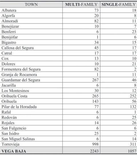
The sample has been stratified into two subsamples based on the typology (multi-family and single-family), due to the fact that they constitute different real estate offers, in which the potential buyers look for incomparable features and therefore present differentiated valuations.
variables such as sale prices and the preferences and needs of potential buyers do not vary significantly. The data was collected between January and August of 2009. The field work was carried out through the compiling of data specific to the present study (73%), market studies for mortgage valuations (21%), market studies for appraisals, expert valuation reports and viability studies (6 %), carried out over the same period.
The utilized data was sufficiently representative and appropriately corrected from unconditional offers. The information was verified and all data that differed unjustifiably from the average market value for the area or that was incomplete, was discarded (Roca, 1987).
The 3,845 pieces of data that made up the original sample were whittled down to a market study consisting of 3,300 units of information, from throughout the entire area. It is a representative sample of the different zones distributed in the following manner.
TOWN MULTI-FAMILY SINGLE-FAMILY
Albatera 73 18
Algorfa 20 8
Almoradí 82 11
Benejúzar 10 7
Benferri 6 23
Benijófar 1 6
Bigastro 34 15
Callosa del Segura 45 17
Catral 17 17
Cox 13 10
Dolores 10 21
Formentera del Segura 82 2
Granja de Rocamora 1 11
Guardamar del Segura 267 46
Jacarilla 6 8
Los Montesinos 30 12
Orihuela Costa 265 252
Orihuela 143 56
Pilar de la Horadada 77 132
Rafal 6 1
Redován 6 25
Rojales 14 26
San Fulgencio 6 6
San Isidro 25 2
San Miguel Salinas 6 14
Torrevieja 998 311
VEGA BAJA 2243 1057
Figure 3: Spatial distribution of the sample. Source: the authors.
Database design and characterization of the sample
In this phase, we attempted to define all of those pieces of data that permit the differentiation of the real estate product from a point of view that is both territorial and related to the demand criteria. This process helped to stratify the sample using criteria of homogeneity, making it possible for us to subsequently conduct explanatory analysis.
The variables or factors for analysis can be grouped together into four families; the first two directed at the characterization of the property and the remaining two at the characterization of the territory:
1 market variables and valuation
2 intrinsic or typological attributes linked to the constructed element and characteristic aspects of the area
3 extrinsic or location related attributes linked to the censual units 4 extrinsic or location related attributes linked to the property
In Family 1, “Market variables and valuation”, different defined aspects include the surveyed sale price, unitary market price and repercussion value of the land. The information sources include real estate agents, specialized publications and real estate and individual’s websites. The variables obtained from the surveyed market values were compiled by the authors for the purpose of the study.
In Family 2, “Typological variables”, the defined aspects include housing programs, construction quality, characteristic typology and occupation levels for properties used as homes, among others. We obtained the characteristic typological variables referring to the territorial scope or censual unit from the data provided by the 2001 Census conducted by the National Institute of Statistics, or compiled by the authors using said data.
Family 3, “Extrinsic territorial variables”, takes into account environmental, economic, social and urban structure factors, with reference to the land unit or censual unit where the sample is located. The characteristic typological variables were obtained from the 2001 Census data conducted by the National Institute of Statistics or compiled by the authors from said data. In Family 4, “Extrinsic values of the variables”, the analyzed factors mainly had to do with the environment, infrastructures and facilities with reference to each sample. The variables were obtained through the compilation of field data by the authors.
Database processing. Distribution of spatial variables.
The resulting data set is introduced in an appropriately coded Excel database, and transformed into factors that will determine the final classification of each part of the territory. To this end, the property register mapping for each town was used as the basis, creating a reliable starting point for geo-referencing each sample, for the subsequent production and quality control of the relevant themes.
The use of GIS as a tool for scientific research (Moldes, 1995) is derived from its capacity to respond to spatial questions (Gutierrez and Gould, 1994). The use of GIS technology makes it possible to create complex maps that represent a territory’s total qualitative value. This in turn will orient and sensitize with respect to the distribution of values that can be geographically located on a territory, and effectively support the implantation of necessary protection regulations. The GIS data structures detect fragile or vulnerable areas within each scope, in addition to areas with greater potential for growth.
both with regards to single-family and multi-family homes. We can determine if there is a link between territorial valuation and the spatial distribution of property values by using the link between the total quality valuation map and the land value map.
The following is a list of the available information that has been incorporated into a Geographic Information System. It is divided into five areas. The following variables were taken into consideration in order to define the territorial valuation
AREA 1 ECONOMIC
x Weight of unemployment rate x Socioeconomic condition by homes
x Active population rate / dependent population rate x Sector / field of activity
AREA 2 ENVIRONMENTAL x Type of landscape
x Conservation value of the territory
x Buffer of influence from the golf course x Buffer of influence from the beach
AREA 3 POPULATION x Average education level x Average age
x Percentage of Spanish / foreign population
AREA 4 INFRASTRUCTURES AND FACILITIES x Buffer of influence from transportation infrastructure x Sanitation facilities
AREA 5 EDIFICATORY TYPOLOGY x Characteristic residential typology x Seasonal variation
x Vacant homes index x Average home size
Territorial valuation. Areas of fragility and potentiality
Valuing the quality of a territory means stipulating a reference value for each of its comprised areas. The concept of “value” incorporates a broad spectrum of different valuations or factors that condition its determination. Once said value has been determined, it becomes possible to estimate the impact of the different actions planned on the territory and articulate mechanisms that will guarantee the preservation of its values.
the territory in each of the areas. The superimposition of said maps allows us to make a qualitative valuation map for the territory.
This map established a value reference for each of the areas, as well as for their spatial interrelationships. In this way, the value becomes a guideline for the study of the different territorial zones offering an integral vision of the area with regards to territorial planning. Once the social demands have been recognized, as well as environmental and economic potentials, we will be in the proper position to establish guidelines that will contribute to improving the sustainable planning process for the territory. In order to qualitatively estimate each of the dimensions of the total value, hierarchical scales with value ranges will be applied to the thematic maps (Moldes, 1995), using said measurement as a reference for determining the critical areas and the areas with a potential for development.
One example of these types of applications (Laurini and Thompson, 1991), was used in the selection of suitable areas for new residences in a part of Maryland where the selection criteria were based on the proximity of fire stations, secondary schools, distances from main highways and flood lands. Also of note are the territorial guidelines established to determine the most suitable area for housing developments in Randstand, Holland (Geertman and Toppen, 1990).
RESULTS. MAP OF TERRITORIAL VALUATION
The final goal of the executed analysis is to determine which areas are fragile, and which have the potential for development. The objective is to create a tool that makes planning decisions easier and favors the selection of the most ideal location with regards to the necessities of each demand profile. The results will therefore be displayed keeping this objective in mind.
Economic fragility
Figures 6 and 7: Impact on the agrarian sector and construction sector within the area’s economic structure. Source: the authors.
An incipient interest in industry can also be observed (Fig. 8) next to the nucleus of Almoradí. This is sparked by the potential of the network of infrastructures and the strong implantation of the service sector (Fig. 9) in the pre-littoral strip that runs alongside Torrevieja.
The new structuring of the production sectors demonstrates a clear reflection of the average socioeconomic levels of the homes and the unemployment and active population rates, while provoking a highly significant fragility from an economic point of view. The coastal and pre-coastal strips are transformed into areas with a strong economic dependence on residential tourism and its related real estate activity. The current economic situation has truly compromised the sustainability of this structure.
Figure 10: Thematic map of economic fragility. Source: the authors.
Environmental fragility
Figures 11 and 12: Landscapes and value for land preservation. Source: the authors.
The loss of the landscape due to the “invasion” of constructed areas provokes critical situations that can be observed on the “Environmental fragility” themed map (Fig. 13). It also illustrates the need to redirect development and not stand in the way of the environmental potential, which has been significantly depleted due to the expansion practices of land markets.
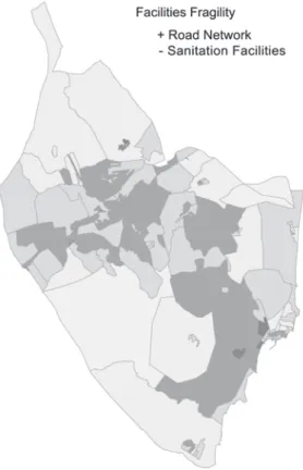
Facilities fragility
A structural and functional analysis of the existing road network makes it possible to detect two corridors that can be considered structurally important to the area (freeway AP-7 Alicante-Cartagena, N-340 and N-332). This also makes it possible to identify the areas, which, in theory, pose more accessibility or interconnection problems, as well as the roads that present the best potential conditions from a functional point of view (Fig. 14). This analysis has been linked to the area’s sanitation facilities, detecting significant scarcities in the pre-littoral strips around Orihuela Costa and Montesinos.
Figures 14 and 15: Areas affected by the road network and sanitation facilities. Source: the authors.
Figure 16: Thematic map of facilities fragility. Source: the authors.
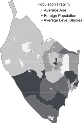
Population fragility
Figures 17 and 18: Average age of the population and percentage of foreign-Spanish population. Source: the authors.
Education levels (Fig. 19) are higher near towns and the pre-littoral strip, due to older (Fig. 17), often foreign (Fig. 18), residential tourists, as opposed to local inhabitants. This structure is easily vulnerable to relevant changes, given that this type of inhabitant, while not temporary, is unstable, and has an uncertain renewal index.
Within this context, there are fragile areas (Fig. 20) with important issues of imbalance with regards to the modification of the population structure.
Figure 20: Thematic map showing population fragility. Source: the authors.
Typological characterization
Figures 21 and 22: Characteristic building typology and average size of homes. Source: the authors.
There is a significant percentage of empty homes (Fig. 23) in the town of Torrevieja and the pre-littoral strip where the colonization process of the countryside, through real estate promotions destined for second homes in previously unpopulated areas, has been most intense. In towns like Almoradí, Dolores, Algorfa, and Catral, the cultivation of un-irrigated crops has been substituted for urbanistic developments that have left a large percentage of homes vacant.
Figures 23 and 24: Index of vacant homes and seasonal variation. Source: the authors.
Territorial valuation and urban value
Figure 25 and 26: Spatial distribution of single-family and multi-family market values. Source: the authors.
The highest market values are found in areas close to the coast that have been subject to intense urban developments destined for second homes. Notwithstanding, these coastal and pre-coastal zones are the most fragile from a territorial point of view. (Fig. 27)
CONCLUSIONS
The area known as the Vega Baja del Segura has undergone an intense transformation process due to the development of the real estate and tourism sectors. This has led to new demands, which are being met through a complex interaction process made up of legal statutes and political decisions, and without a clear renunciation of its “rurality”. The area’s development is an unequivocal example of the expansionist policies of the land market that have played out along the Spanish coast during the last two decades. The result has been a significant increase in residential land and a gradual loss of the territory’s environmental values.
A justification for keeping the rural spaces alive can be found in the paradigm of sustainability, understood to be a safeguard for the environment. The medium is used as a mechanism for nature conservation and the endowment of green spaces, and as support for resources having to do with the landscape, recreation and tourism; not to mention as an indispensable space for creating areas or discontinuity between urban agglomerations.
Rural spaces are now fulfilling a new function. The different areas must be maintained in a sustainable manner a network of essential elements for achieving a balance between territory, the environmental and the landscape. This will be able to answer to an aspiration that modern societies demand as a fundamental component of quality of life.
The proposed valuation system is a tool for the global evaluation of a territory. Its usefulness is in demonstrating the territory's critical points in order to contribute to its sustainable development. The conflicts and opportunities can be evaluated through the logic of the resulting relationships. The result is a map of global valuation that points out environmental limitations, societal demands and economic potentialities. The area of Vega Baja del Segura has undergone a growing number of interventions that have been detrimental to the sustainable integration of the medium’s more disturbing elements. The qualitative valuation of the territory has made it possible to detect its drastic division into two zones that are leading to a clear break in the area’s structure. This break was mainly caused by factors relating to population and economic issues, which have had a decided influence on the area’s development.
The obtained valuations are practically mimetic with regards to variables like the percentage of foreign-Spanish population, average age of the population and the seasonal variation. This demonstrates the clear dependence between the typological characteristics of the real estate product and the population structure.
What would be the development process for this model, based on suburban growth linked to tourism and construction, if this clear structure were drastically modified? Does this constitute a merely immediate problem, or does it open a breach in the area’s structure that will be extremely difficult to resolve? Should the territorial value be protected or consumed? It should be pointed out that the highest market values, linked to the very intense urban developments that have taken place over the last few years, are associated with those zones where they are overlapped by the greatest environmental, economic and population-based fragilities. We therefore find ourselves in a real estate market that doesn’t truly respond to the territorial characterization, but rather to extraterritorial conditions that have defined both the population and economic structure.
questions points out the need to redirect development, without obviating the potentiality of the area. An indispensable tool for achieving these objectives is the designing of an urban planning that contributes to a sustainable development and adjust to the real needs of the territory. .
BIBLIOGRAPHY
- Beaumont, J. R., GIS and Market Analysis, En: Maguire, D. J., Good-child, MF, Geographical Information Systems. Harlow, Longman, 1991.
- Crompton, J., The Impact of Parks on Property Values, Department of Recreation, Park and Tourism Sciences Texas A&M University, 2007
- Devore, Jay L., Probabilidad y estadística para ingenieria y ciencias, Thomson Learning, Inc., México, D.F., 2005.
- Geertman, M. Toppen, F. J., The Applications of a GIS for the allocation of land for Housing in the Randstad Holland, Worral, L. Ed: Geographic Information Systems, Developments and Applications. Londres, 1990.
- Gutiérrez Puebla, J. Gould, M., SIG: Sistemas de Información Geográfica, Editorial Síntesis, Madrid, 1994.
- Halfacree, K., Rethinking ´rurality´. In: New forms of urbanisation, beyond the urban-rural dichotomy, Aldershot, Ashgate, 2004.
- Kauko, T. D’Amato, M., Mass Appraisal Methods. An International Perspective for Property Valuers, Blackwell Publishing Ltd, Oxford, 2008.
- Laurini, R Thompson, D., Fundamentals of Spatial Information Systems, Academic Press, Londres, 1992.
- Leinfelder, H., A more strategic zoning plan for rural areas under urban pressure, Association of European schools of Planning AESOP, 2007
- Moldes, F. J., Tecnología de los sistemas de información geográfica, RA-MA Editorial, Madrid, 1995.
- Overbeek, G. Terluin, I., Rural Areas Under Urban Pressure. Case studies of rural-urban relationships across Europe, Report 7.06.01 LEI Wageningen UR, The Hague, 2006 - Roca Cladera, J., La estructura de los valores urbanos: Un análisis teórico-empírico,