Physical and economic impacts due to sea level changes and wind waves around the Balearic Islands
134
0
0
Texto completo
(2)
(3) Doctoral Thesis 2019 Doctoral programme of Physics PHYSICAL AND ECONOMIC IMPACTS DUE TO SEA LEVEL CHANGES AND WIND-WAVES AROUND THE BALEARIC ISLANDS.. Alejandra Rodrı́guez Enrı́quez Thesis Supervisor: Marta Marcos Moreno Thesis Supervisor: Angel Bujosa Bestard Thesis Tutor: Damià Gomis Bosch. Doctor by the University of Balearic Islands.
(4)
(5)
(6)
(7) List of publications included in the Doctoral Thesis:. Enrı́quez, A. R., Marcos, M., Álvarez-Ellacurı́a, A., Orfila, A., Gomis, D., 2017. Changes in beach shoreline due to sea level rise and waves under climate change scenarios application to the Balearic Islands. Natural Hazards and Earth System Sciences, 17, 1075-1089. Enrı́quez, A. R., Marcos, M., Falqués, A., Roelvink, D., 2019. Assessing beach and dune erosion and vulnerability under sea level rise: a case study in the Mediterranean Sea. Frontiers in Marine Science, 6:4. Enrı́quez, A. R., Bujosa, A., 2019. Measuring the economic impact of climateinduced environmental changes on sun-and-beach tourism. Under review in Climatic change.. The 2017 quality indexes of the journals where articles are published (or under review) are: Journal. CiteScore. Category Name. Total Journals Journal Rank Percentile in in Category. NHESS1 2. FMARS. CC3. 2.43. Earth and Planetary Sciences. 2.89. Ocean Engineering. 4.06. in Category. Category. 182. 22. 88th. 91. 6. 93rd. Aquatic Science. 199. 20. 90th. Oceanography. 115. 15. 87th. Atmospheric Science. 102. 9. 91st. 65. 13. 80th. Global Planetary Change 1. Natural Hazards and Earth System Sciences. 2. Frontiers in Marine Science. 3. Climatic Change.
(8)
(9) Dr. Marta Marcos Moreno, of University of Balearic Islands. I DECLARE: That the thesis titled “Physical and economic impacts due to sea level changes and wind-waves around the Balearic Islands”, presented by Alejandra Rodrı́guez Enrı́quez to obtain a doctoral degree, has been completed under my supervision and meets the requirements to opt for an International Doctorate. For all intents and purposes, I hereby sign this document.. Signature. Palma de Mallorca, October, 2019..
(10) Dr. Angel Bujosa Bestard, of University of Balearic Islands. I DECLARE: That the thesis titled “Physical and economic impacts due to sea level changes and wind-waves around the Balearic Islands”, presented by Alejandra Rodrı́guez Enrı́quez to obtain a doctoral degree, has been completed under my supervision and meets the requirements to opt for an International Doctorate. For all intents and purposes, I hereby sign this document.. Signature. Palma de Mallorca, October, 2019..
(11)
(12)
(13) A mi hermana Reyes, porque quisiste aprender qué es “batimetrı́a”, “Matlab” o “paper”..
(14)
(15) Agradecimientos. Ahora, después de añadir el punto final a este documento, puedo afirmar que sé qué es y qué conlleva hacer una tesis. Puede parecerse a la idea de un camino que te han dicho que está ahı́ pero el cual tienes que descubrir haciéndote paso entre una vegetación amazónica que te impide ver por dónde vas. El camino normalmente se empieza con una caja de herramientas casi vacı́a, las pocas herramientas que hay están nuevas y el manual de instrucciones te lo has leı́do . . . en diagonal. Menos mal que a mi lado iba algo parecido a Indiana Jones, Willy Fog, James Bond o MacGyver (elige tu favorito) que hizo que pudiese disfrutar de la tesis a pesar de que apareciesen serpientes venenosas de la especie “Validations horribilus”, escorpiones “Simulacionus erronious” o arañas “Primeros papers” (debo anotar que el nombre de la araña inicialmente iba en singular pero siendo fiel a la realidad . . . sigue siendo una amenaza). Aunque lo peor de todo es la humedad densa a tu alrededor que podemos bautizar como una “no tengo ni idea” o “yo no sirvo para esto” que a veces hace que te sientas muy pequeña. En mi caso, he tenido la suerte de tener una directora que me apoyó siempre y estas sensaciones no fueron recurrentes. Aunque por otro lado, a veces los directores te tiran a acantilados o cuevas en los que no sabes lo que hay, de los que sales desconcertada, con arañazos y un poco sucia, pero con muchos más conocimientos, haya salido bien o mal la aventura. Gracias Marta y gracias Angel, el camino ha sido mucho más fácil con vosotros. He aprendido mucho de ciencia, pero sobre todo, siento que he crecido como persona. Me siento afortunada de haberos conocido y de haber compartido un tiempo de mi vida con vosotros. Esta tesis es vuestra. Siguiendo con la historia, Indiana Jones, Willy Fog, James Bond o MacGyver no van solos, siempre tienen a un colaborador o colaboradores a su lado que facilitan mucho la tarea del investigador y de sus estudiantes. Muchas gracias por toda vuestra ayuda a lo largo de mi tesis, hay mucho de vosotros en ella. Desde el principio y hasta el final, habéis estado a mi lado limpiando el camino, gracias Juanma y gracias Ángel vii.
(16) Amores. Y por supuestı́simo gracias a todo el grupo que, de veras, admiro: Damià, Sebas, Biel, Javi y Miguel. En los márgenes del camino y con las herramientas en el suelo, están otros pequeños pimpollos que descansan después de haber estado trabajando en sus propias tesis. Con ellos he pasado mi tiempo libre, desahogado penas en el despacho, debatiendo e incluso conviviendo. También hemos descubierto Palma por el dı́a y por la noche, hemos hecho mil y una excursiones a la montaña, a la verbena, a la playa, etc. Si es que la vida del doctorando no está tan mal como dicen. Gracias a todas/os por estar ahı́ y hacer este viaje mucho más divertido y acogedor: Laura, Carlota, Xisca, Julia, Vero, Paula, Noe, Inma, Albert, Guille Lara, Dani Chaparro, Nuria y Miguel (sı́, el mismo que el de arriba). Ahora entiendo la expresión “no puedo expresar con palabras lo que siento”, pero creo que vosotras/os lo sabéis. Y por supuesto, gracias a toda la gente del IMEDEA que crea un ambiente genial en el instituto, hasta te sientes bien cuando estás trabajando. Los mejores momentos son en el ágora comiendo, debatiendo, haciendo porras de polı́tica con Melo, Guille, Edu, Joan Pons, Esther, Angel, etc. Sé que me dejo a muchos pero ya sabéis, prisas y más prisas (o como se dice en ciencia “deadlines”). Desde casa, ¡Ay que morriña!, he sentido el apoyo de mis amigas de toda la vida, unas verdaderas guerreras amazónicas que luchan por cumplir sus propios deseos ya sea en Galicia o desde diversos rincones del mundo. Os he echado de menos muchas veces: Carmela, Ana, Cris, Sofı́a, Reyes (se repite, ya veréis), Sara y Aida. Y por supuesto a mi familia. Creo que me estoy volviendo un poco sentimental con el tiempo/espacio o a medida que escribo estos agradecimientos o quizás lo he sido siempre. Bueno, vosotros me conocéis mejor que nadie. Aquı́ el mensaje es sencillo. Os quiero (mucho) y siento no estar con vosotros (mucho), Urbano, Marı́a, abuela (Marı́a de los Ángeles, pero ni yo me acordaba de tu nombre, ası́ que “abuela”) y Reyes. Gracias a vosotros tengo la caja de herramientas, las instrucciones que no leo y a mı́ misma. En definitiva, la base sin la cual no podrı́a estar aquı́ hoy ni ser quién soy. También os quiero y me gustarı́a veros más, tı́os, sobrinos, primos, etc. Y te quiero y siento no estar ahı́, Galicia. No se me olvida agradecerle su aguante (sı́ amigos, aguante) a mi lado, desde el principio y hasta el final y en todos los aspectos de mi vida (esta es su tercera mención en estos agradecimientos). Has estado abriendo conmigo mi camino al mismo tiempo. viii.
(17) que el tuyo, me has apoyado y hemos descansado juntos. Incluso a veces nos hemos escapado al rı́o. Gracias Miguel. Todo esto no hubiese sido posible sin el apoyo económico del Ministerio de Economı́a de España, que ha financiado el proyecto CLIMPACT (CGL2014-54246-C2-1-R) en el que se engloba la presente tesis. Gracias también al IMEDEA (Instituto Mediterráneo de Estudios Avanzados), lugar en el que se ha desarrollado todo este periplo.. ix.
(18) x.
(19) Abstract. This thesis investigates and quantifies the impacts caused by climate change in the coasts of Balearic Islands (western Mediterranean Sea) from both a physical and an economic perspective. Two physical mechanisms that generate coastal hazards are considered in this work: mean sea-level rise and wind-waves. Their impacts are assessed, separately and jointly, in three case studies that have been selected due to the amount of available observations of nearshore waves, shoreline position and topo-bathymetries; these are two urban beaches (located in Mallorca island) and one natural beach (in Menorca island). The relevance of sandy coasts in the Balearic Islands, and in general in the Mediterranean coastal communities, is evident in terms of coastal protection but also from an economic point of view since sun-and-beach tourism is the main economic activity of the region. The physical impacts on the beaches are investigated using numerical modelling to simulate the shoreline retreat, the beach erosion and the beach vulnerability resulting from projected mean sea-level rise and wind-wave changes up to 2100. The methodology and the assumptions vary depending on the hydro- and morphodynamical processes required to study the coastal impacts in each case. In addition, numerical simulations are validated against observations whenever possible, prior to the application of the modelling setup under projected future conditions. Our results for urban beaches, highly anthropised and backed by infrastructures such as promenades and buildings, indicate a permanent loss of approximately half of the present-day beach area; in addition, the beach is expected to be almost completed flooded under storm conditions. In other words, urban beaches are unable to respond to long-term changes in the oceanic forces. In the case of the natural beach, our results anticipate that the beach will retreat at the expense of the dune area located behind it. A noteworthy finding is the importance of simulating the beach morphological features when assissing beach impacts, which play a key role in the beach erosion rates. xi.
(20) The economic impact on sun-and-beach tourism is measured by means of a choice experiment application. More precisely, the shoreline retreat projections obtained for the urban beach cases studies are used to estimate the welfare loss that tourists would experiment in a future scenario characterized by a reduction of the beach size, in addition to two other climate-induced environmental changes. Data on the socioeconomic and the travel profile of tourists as well as their preferences for different policies aimed at reducing climate-induced environmental changes, was collected through a survey conducted in the high season of 2016 at the airport of Palma (Mallorca). Overall, results show that sun-and-beach tourists have a positive willingness-to-pay to reduce climate change impacts. At the same time, the mixed logit specification accounting for preference heterogeneity allows to find that the welfare loss varies across tourists depending on their socioeconomic and travel characteristics.. xii.
(21) Resumen. Esta tesis investiga y cuantifica los impactos causados por el cambio climático en las costas de las Islas Baleares (Mediterráneo occidental) desde un punto de vista tanto fı́sico como económico. Dos mecanismos fı́sicos, los cuales suponen una amenaza para las zonas costeras, son considerados en este trabajo: el aumento del nivel medio del mar y el oleaje. Sus impactos se evalúan, tanto de forma separada como conjuntamente, en tres casos de estudio que han sido seleccionados debido a la disponibilidad de observaciones de oleaje costero, posición de lı́nea de playa y topo-batimetrı́as: dos playas urbanas (ubicadas en la isla de Mallorca) y una playa natural (en la isla de Menorca). La relevancia de las costas arenosas en las Islas Baleares, y en general en las comunidades costeras del Mediterráneo, es evidente en términos de protección costera, pero también desde un punto de vista económico ya que el turismo de sol y playa es la principal actividad económica de la región. Los impactos fı́sicos en las playas se estudian mediante el uso de modelos numéricos con los que se simula el retroceso de la lı́nea de costa, la erosión y la vulnerabilidad de las playas como resultado del esperado aumento del nivel medio del mar y los cambios en el oleaje hasta 2100. La metodologı́a y las premisas aplicadas varı́an dependiendo de los procesos hidro- y morfodinámicos necesarios para estudiar los impactos costeros en cada caso. Además, antes de ejecutar los modelos numéricos bajo condiciones oceánicas futuras, las simulaciones numéricas son validadas con observaciones en los casos en los que es posible. Nuestros resultados para las playas urbanas, las cuales presentan paseos marı́timos y edificios tras ellas y por lo tanto, un alto nivel de antropización, indican una pérdida permanente de la playa de aproximadamente la mitad de su área actual. Además, el área de playa afectada por la inundación aumenta hasta su casi totalidad en condiciones de tormenta. En otras palabras, las playas urbanas son incapaces de responder a cambios de largo plazo en las fuerzas oceánicas. En el caso de la playa natural, nuestros resultados anticipan un retroceso, pero no pérdida, que xiii.
(22) conlleva la desaparición del área dunar localizada detrás. Un resultado destacable es la importancia de simular las caracterı́sticas morfológicas de la playa cuando se evalúan impactos costeros, las cuales desempeñan un papel clave en las tasas de erosión de la playa. El impacto económico en el turismo de sol y playa se mide mediante un experimento de elección. Más concretamente, los resultados de retroceso de lı́nea de costa obtenidos en el estudio de las playas urbanas se utilizan para estimar la pérdida de bienestar que el turista experimentarı́a por la reducción del tamaño de playa, además de por otros dos cambios ambientales provocados por el cambio climático. El perfil socioeconómico y de viaje de los turistas, ası́ como sus preferencias hacia distintas polı́ticas orientadas a reducir los impactos del cambio climático, se obtuvieron mediante una encuesta realizada en la temporada alta de 2016 en el aeropuerto de Palma (isla de Mallorca). En general, los resultados muestran que los turistas de sol y playa tienen una disponibilidad a pagar positiva para reducir los impactos del cambio climático. Al mismo tiempo, el modelo logit mixto, que captura la heterogeneidad de preferencias entre los individuos, permite observar que la pérdida de bienestar de los turistas varı́a entre sus caracterı́sticas socioeconómicas y de viaje .. xiv.
(23) Resum. Aquesta tesi investiga i quantifica els impactes causats pel canvi climàtic a les costes de Illes Balears (Mediterrània occidental) des d’un punt de vista tant fı́sic com econòmic. Dos mecanismes fı́sics, els quals suposen una amenaça per a les zones costaneres, són considerats en aquest treball: l’augment del nivell mitjà del mar i l’onatge. Els seus impactes s’avaluen, tant de forma separada com conjuntament, en tres casos d’estudi que han estat seleccionats per la disponibilitat d’observacions d’onatge costaner, posició de lı́nia de platja i topo-batimetries: dues platges urbanes (ubicades a l’illa de Mallorca) i una platja natural (a l’illa de Menorca). La rellevància de les costes arenoses a les Illes Balears, i en general en les comunitats costaneres de la Mediterrània, és evident en termes de protecció costanera, però també des d’un punt de vista econòmic ja que el turisme de sol i platja és la principal activitat econòmica de la regió. Els impactes fı́sics a les platges s’estudien mitjançant l’ús de models numèrics amb els quals es simula el retrocés de la lı́nia de costa, l’erosió i la vulnerabilitat de les platges com a resultat de l’augment esperat del nivell mitjà del mar i els canvis en l’onatge fins al 2100. La metodologia i les premisses aplicades varien depenent dels processos hidro- i morfodinàmics necessaris per estudiar els impactes costaners en cada cas. A més, abans d’executar els models numèrics sota condicions oceàniques futures, les simulacions numèriques són validades amb observacions en els casos en què és possible. Els nostres resultats per a les platges urbanes, les quals presenten passeigs marı́tims i edificis darrere d’elles i per tant, un alt nivell d’antropització, indiquen una pèrdua permanent de la platja d’aproximadament la meitat de la seva àrea actual. A més, l’àrea de platja afectada per la inundació augmenta fins gairebé la seva totalitat en condicions de tempesta. En altres paraules, les platges urbanes són incapaces de respondre a canvis de llarg termini en les forces oceàniques. En el cas de la platja natural, els nostres resultats anticipen un retrocés, però no pèrdua, que comporta la desaparició de l’àrea dunar localitzada darrere. Un resultat destacable és la importància xv.
(24) de simular les caracterı́stiques morfològiques de la platja, les quals tenen un paper clau en les taxes d’erosió de la platja. L’impacte econòmic del turisme de sol i platja es mesura mitjançant una aplicació d’experiments d’elecció. Més concretament, els resultats del retrocés de la lı́nia de costa obtinguts a l’estudi de les platges urbanes s’utilitzen per estimar la pèrdua de benestar que els turistes experimentarien en un escenari futur caracteritzat per una reducció de la superfı́cie de platja, a més i dos altres canvis ambientals provocats pel canvi climàtic. El perfil socioeconòmic i de viatge dels turistes, aixı́ com les preferències dels turistes per a diferents polı́tiques dirigides a reduir els impactes del canvi climàtic, es van obtenir mitjanç una enquesta realitzada ala temporada alta de 2016 a l’aeroport de Palma (Mallorca). En general, els resultats mostren que els turistes de sol i platja tenen una disposició a pagar positiva per reduir els impactes del canvi climàtic. Al mateix temps, el model logit mixt, que captura l’heterogeneı̈tat de preferències entre els individus, permet observar que la pèrdua de benestar dels turistes varia en funció de les seves caracterı̀stiques socioeconòmiques i de viatge.. xvi.
(25) Contents. 1. General Introduction. 1. 1.1. Global climate change and sea-level rise . . . . . . . . . . . . . . . . . .. 1. 1.1.1. Present-day mean sea-level and future projections . . . . . . . . .. 2. 1.1.2. Extreme sea-level changes . . . . . . . . . . . . . . . . . . . . .. 4. Coastal impacts . . . . . . . . . . . . . . . . . . . . . . . . . . . . . . .. 4. 1.2.1. Physical impacts . . . . . . . . . . . . . . . . . . . . . . . . . . .. 5. 1.2.2. Economic impacts . . . . . . . . . . . . . . . . . . . . . . . . . .. 7. 1.3. The case of the Mediterranean Sea . . . . . . . . . . . . . . . . . . . . .. 8. 1.4. Objectives of this thesis: a case study in the Balearic Islands . . . . . . .. 9. 1.5. Numerical simulation of physical impacts . . . . . . . . . . . . . . . . . 11. 1.6. Assessment of economic impacts . . . . . . . . . . . . . . . . . . . . . . 12. 2. Changes in beach shoreline due to sea-level rise and waves under cli-. 1.2. mate change scenarios: application to the Balearic Islands (Western Mediterranean).. 15. 2.1. Introduction . . . . . . . . . . . . . . . . . . . . . . . . . . . . . . . . . 15. 2.2. Data and Methods . . . . . . . . . . . . . . . . . . . . . . . . . . . . . . 17. 2.3. 2.4. 2.2.1. Topo-bathymetric surveys . . . . . . . . . . . . . . . . . . . . . . 18. 2.2.2. Hydrodynamic data . . . . . . . . . . . . . . . . . . . . . . . . . 18. 2.2.3. Video imagery data . . . . . . . . . . . . . . . . . . . . . . . . . 19. 2.2.4. Numerical approach . . . . . . . . . . . . . . . . . . . . . . . . . 20. 2.2.5. Forcing of numerical models . . . . . . . . . . . . . . . . . . . . 22. Evaluation of model setup under present-day climate conditions . . . . . . 25 2.3.1. Comparison with wave observations . . . . . . . . . . . . . . . . 25. 2.3.2. Comparison with observed shoreline position . . . . . . . . . . . 28. Shoreline changes under climate change scenarios . . . . . . . . . . . . . 31.
(26) 2.5. Summary and conclusions . . . . . . . . . . . . . . . . . . . . . . . . . . 37. 3. Assessing beach and dune erosion and vulnerability under sea-level rise: a case study in the Mediterranean Sea.. 39. 3.1. Introduction . . . . . . . . . . . . . . . . . . . . . . . . . . . . . . . . . 39. 3.2. Data . . . . . . . . . . . . . . . . . . . . . . . . . . . . . . . . . . . . . 42. 3.3. 3.4. 3.2.1. Site Description . . . . . . . . . . . . . . . . . . . . . . . . . . . 42. 3.2.2. Wave Data . . . . . . . . . . . . . . . . . . . . . . . . . . . . . . 43. 3.2.3. Mean Sea-Level Data . . . . . . . . . . . . . . . . . . . . . . . . 44. Material and methods . . . . . . . . . . . . . . . . . . . . . . . . . . . . 44 3.3.1. Numerical Models . . . . . . . . . . . . . . . . . . . . . . . . . . 45. 3.3.2. Estimation of the Shoreline Retreat . . . . . . . . . . . . . . . . . 47. 3.3.3. Beach and Dune Vulnerability and Erosion . . . . . . . . . . . . . 49. Results . . . . . . . . . . . . . . . . . . . . . . . . . . . . . . . . . . . . 50 3.4.1. Shoreline Retreat Under Mean Sea-Level Rise . . . . . . . . . . . 50. 3.4.2. Beach and Dune Vulnerability and Erosion . . . . . . . . . . . . . 52. 3.5. Conclusion . . . . . . . . . . . . . . . . . . . . . . . . . . . . . . . . . . 55. 4. Measuring the economic impact of climate-induced environmental changes on sun-and-beach tourism.. 57. 4.1. Introduction . . . . . . . . . . . . . . . . . . . . . . . . . . . . . . . . . 57. 4.2. Application and survey design . . . . . . . . . . . . . . . . . . . . . . . 59. 4.3. 4.2.1. Climate-induced environmental changes in the Mediterranean coast 59. 4.2.2. The choice experiment . . . . . . . . . . . . . . . . . . . . . . . 60. 4.2.3. Survey and sample . . . . . . . . . . . . . . . . . . . . . . . . . 62. Methods . . . . . . . . . . . . . . . . . . . . . . . . . . . . . . . . . . . 64 4.3.1. The mixed logit model . . . . . . . . . . . . . . . . . . . . . . . 64. 4.3.2. Welfare measurement . . . . . . . . . . . . . . . . . . . . . . . . 67. 4.4. Results . . . . . . . . . . . . . . . . . . . . . . . . . . . . . . . . . . . . 67. 4.5. Conclusions . . . . . . . . . . . . . . . . . . . . . . . . . . . . . . . . . 71. 5. Summary and Conclusions.. 73. 6. Main findings.. 77.
(27) List of Figures . . . . . . . . . . . . . . . . . . . . . . . . . . . . . . . . . . . 99 List of Tables . . . . . . . . . . . . . . . . . . . . . . . . . . . . . . . . . . . . 103 List of Terms and Abbreviations. 105.
(28)
(29) Chapter 1. General Introduction. 1.1. Global climate change and sea-level rise. The Intergovernmental Panel on Climate Change (IPCC), the United Nations body for assessing the science related to climate change defined, more than a decade ago in its fourth assessment report (IPCC 2007b), climate change as “a change in the state of the climate that can be identified by changes in the mean and/or the variability of its properties (. . . ) It refers to any change in climate over time, whether due to natural variability or as a result of human activity.” Since then, it has been established that human contribution to climate change ranges between 93-123% during the period 1951-2010 (Knutson et al. 2017) due to the emission of greenhouse gases (GHG) released to the atmosphere associated to the anthropogenic activities. Increasing GHG concentrations and the resulting changes in the climate system have produced a cascade of global consequences, from physical effects to impacts in biological and socioeconomic systems. Among them are rising of global air and ocean temperatures, melting of snow and ice, mean sea-level rise, changes in the intensity of North Atlantic tropical cyclone activity and variations in precipitation rates and patterns (IPCC 2013). Given the magnitude of the anthropogenic contribution to contemporaneous climate change, throughout this thesis, we will refer only to human-induced changes when quoting climate change. Among the consequences of climate change, mean sea-level rise is one of the potentially most hazardous and costliest aspects, with important implications to the highly populated coastal zones. Globally averaged, mean sea-level rise results from two causes, namely thermal expansion of sea water (due to ocean warming) and fresh water mass input from land-based ice melting (IPCC 2013). Regionally, mean sea-level trends show significant departures from its global mean associated to patterns of differential heat uptake, ocean circulation and surface mass redistribution fingerprints. Locally, changes in mean sea-level exacerbate to a large extent the coastal impact of extreme sea-levels caused by wind-waves (waves hereafter) and storm surges, as it defines the baseline level upon which extreme events reach the coastlines (Marcos and Woodworth 2017, Vousdoukas et al. 2017). In the present thesis, we present the assessment of physical and economic impacts 1.
(30) Alejandra R. Enrı́quez induced by climate change in three coastal case studies. In the following, we describe in more detail the state-of-the-art of mean and extreme sea-level changes and their physical and economic impacts along the coastal regions. 1.1.1. Present-day mean sea-level and future projections. Due to its importance to the coastal zones, much research has been focused on the assessment and quantification of mean sea-level changes at spatial scales from global to local. Very often this research uses sea-level observations that are obtained from in-situ tide gauges, satellite radar altimetry or a combination of both. These two complementary data sets differ, primarily, in the record length and the spatial and temporal resolution. On the one hand, tide gauges provide long sea-level time series (some of them started circa 1700) with high temporal sampling although limited to a set of coastal locations. In addition, the number of operating tide gauges has been changing over time with a different rate over the northern and southern hemispheres (Church and White 2011). On the other hand, remote sensing satellite altimetry data have a significantly shorter temporal coverage, with records starting in early 1990s. However, its near-global spatial coverage provides an improvement in the global scale sea-level observations. An important difference between these two sea-level data sets is their reference system. Satellite altimetry measures sea-level with respect to the Earth’s reference ellipsoid (termed as “absolute sea-level”), while tide gauges record the local sea-level relative to the land upon which they are grounded. In consequence, for the two data sources to be comparable, tide gauge records must be corrected for global and local vertical motions of the Earth’s crust (Cazenave et al. 1999, Dangendorf et al. 2017, Wöppelmann and Marcos 2016). On the large scale, the vertical land movement is dominated by the Glacial Isostatic Adjustment (GIA) (Peltier 2004) signal, a response of the Earth’s crust to the melting from the Late Pleistocene ice-sheets. Conversely, local, small-scale vertical land motions have a broader range of causes from anthropogenic (groundwater pumping, deforestation, drainage of wetlands, etc) to natural processes (earthquakes, volcanism and sediment compaction) (Gornitz 1995). While the GIA signal is routinely removed from sea-level observations using solid Earth model outputs, the local vertical land motions are far more difficult to address and, in general, impossible to model. Thus, whenever possible, local vertical land motions are estimated using precise measurements of ground motions provided by Global Navigation Satellite Systems (GNSS), the most extended of which is the Global Positioning System (GPS) (Wöppelmann and Marcos 2016). Satellite altimetry observations have shown that mean sea-level changes are not globally uniform but exhibit significant regional variations. These variations are the. 2.
(31) Impacts of climate change on Balearic shores result of various factors, the most important of which is the variability in the steric (i.e. density-driven) contribution that, in turn, is dominated by temperature changes, while salinity plays a minor role (Antonov et al. 2002). Likewise, the spatial variability of the mean sea-level responds also to surface wind stress anomalies and, to a lesser extent, to buoyancy forcing anomalies and the intrinsic oceanic variability (Meyssignac et al. 2017). In addition, surface mass load redistribution resulting from the melting of landbased ice-sheets (Antarctica and Greenland) and glaciers generates spatial footprints in the gravitational field and, in consequence, also in mean sea-level (Mitrovica et al. 2001). The study of global mean sea-level (GMSL) rise remains a matter of interest for the scientific community, as it represents one of the metrics that measures the impact of climate change. A number of methods exist that have reconstructed GMSL during the last decades, using different datasets, corrections and with different assumptions. Based on these reconstructions, the resulting linear trends of GMSL during the 20th century range from 1.3 to 2 mm yr−1 (Church and White 2011, Jevrejeva et al. 2014, Hay et al. 2015, Dangendorf et al. 2017, Marcos and Woodworth 2017). There is a growing consensus in pre-altimetry GMSL rise of 1.1 ± 0.3 mm yr−1 before 1990, while GMSL has been rising by 3.4 ± 0.4 mm yr−1 since 1993, according to altimetry observations. Kopp et al. (2016) demonstrated that contemporaneous GMSL rise since the early 20th century is the largest in, at least, the last 2700 years. Future projections of GMSL changes have been obtained as the sum of the outputs of 21 Atmospheric-Ocean General Circulation Models (AOGCMs). The uncertainties derived of using these 21 AOGMs combined with the uncertainties in modelling the contributions to GMSL, have been used to provide future GMSL change estimations in terms of probability (IPCC 2013, Stammer et al. 2019). According to the last IPCC assessment report (IPCC 2013), the future GMSL will likely be in the range of 0.360.71 m (0.53 m) and 0.52-0.98 m (0.74 m) by 2100 (median values), under a moderate RCP4.5 and a pessimistic RCP8.5 climate change scenario, respectively. Following the IPCC nomenclature, the likely range refers to the interval 17-83% of a not symmetric probability density function obtained from the model set and contributions spread, while likely indicates the 66-100% probability. Regional deviations from the mean, resulting from the processes discussed above, can reach up to 50% of the global values (Slangen et al. 2014). In terms of coastal impacts, it is this regional/local value of mean sea-level projections that matters, since it will determine the level upon which marine extremes will reach the shorelines.. 3.
(32) Alejandra R. Enrı́quez 1.1.2. Extreme sea-level changes. Extreme sea levels are particularly important for coastal regions since they are responsible of the major flooding and erosion events. Extreme sea-levels arise from the combination of mean sea-level, tides, extreme waves and storm surges, although only mean sea-level and waves are considered in the present thesis. Among them, mean sealevel has been the largest contributor to the extreme water level during the last decades (Marcos and Woodworth 2017, Vousdoukas et al. 2018). In addition, in shallow water environments, non-linear interactions among these components may occur; for example, with mean sea-level producing changing waves, tides and storm surges (e.g. Arns et al. 2017). As occurs to mean sea-level, extreme storm surges and waves also vary spatially. Spatial patterns of storm surges have been described at the global and regional scales using the worldwide network of tide gauge observations (Menéndez and Woodworth 2010, Marcos and Woodworth 2017). Variations on waves, including extreme waves, are more difficult to assess due to the lack of an extensive network of in-situ observations although satellite radar altimetry and the longer term voluntary observing ships data have been used for this purpose (Gulev and Grigorieva 2004, Young 1999). Projections of waves during the 21st century have been obtained using atmospheric pressure and wind fields from AOGCMs to force either dynamical or statistical models (e.g. Hemer et al. 2013, Mentaschi et al. 2017, Vousdoukas et al. 2016). Model projections indicate that, along most of the coasts worldwide changes in sea-level extremes are small in comparison with the projected mean sea-level rise and its associated uncertainties (Vousdoukas et al. 2018). In other words, the major source of uncertainty in extreme sea-level evolution during the present century is associated to projected mean sea-level rise. In addition, over large continental shelves of shallow depths, storm surges may be further modified by the changing bathymetry as mean sea-level rises. The same principle applies to tidal waves, which are also expected to be modified in all coastal points, sometimes with significant trends (Mawdsley et al. 2015).. 1.2. Coastal impacts. The wide range of coastal hazards caused by mean sea-level rise (including flooding, submersion, saltwater intrusion, permanent shoreline retreat and erosion) constitute a major threat to coastal communities, not only for their effects on the ecosystem but also for their impacts on coastal infrastructures, economic activities and human health. Furthermore, these impacts can be exacerbated by short-term oceanic forces such as storm waves, as well as by human actions (Nicholls and Cazenave 2010). This section presents a short (and inevitably limited) review of the start-of-the-art research on these impacts focusing on sandy coasts, as it is the central topic of this PhD dissertation. For. 4.
(33) Impacts of climate change on Balearic shores the sake of clarity, the review is divided in two parts to introduce, first, the research on the physical impacts caused by mean sea-level rise and, second, the research devoted to quantify their economic impact. 1.2.1. Physical impacts. The variety of coastal hazards derived of sea-level rise is reflected into a wide range of studies dealing with climate change impacts on coasts, including, for example, flooding (Nicholls 2002), submersion of low-lying delta areas (Sayol and Marcos 2018), impacts in aquifers and groundwater reservoirs (Bobba et al. 2000, IPCC 2007a), erosion of cliffs and platforms (Naylor et al. 2010) and changes in intertidal ecosystems (Alongi 2008). For a revision of the potential impacts of sea-level rise on coasts, the reader is referred to Wong et al. (2014). Particular attention has been paid to the study of the responses of sandy beaches, owing to their relevance to coastal protection, coastal ecosystem, local economy and their high value for recreation and residences (Lee 2008, Ruggiero et al. 2013, Vitousek et al. 2017, Wong et al. 2014). Among the typology of coastal landforms (e.g. barrier islands, sea cliffs, tidal flats, river deltas, ports, etc.), sandy coasts compose the 31% of the world’s ice-free shoreline. Nowadays, 48% of beaches are stable, 24% are eroding at ∼0.5 m yr−1 and 28% are accreting, according to a recent study (Luijendijk et al. 2018). However, mean sea-level rise threatens the current state of the natural beaches around the world (Vitousek et al. 2017). The anticipation of shoreline retreat and beach erosion in response to climate change is a challenging topic, with uncertainties arising from mean sea-level changes but also from the difficulty of modelling the erosive impact of changing sea-levels (Le Cozannet et al. 2019). One of the reasons is the highly dynamic character of sandy coasts: the beach morphology, composed by non-consolidated sediment, responds relatively quickly to changes in external forcing such as waves, sea-level, currents and river flows. Likewise, its morphology affects to the same external forcing, leading to a complex feedback system. In addition to this complexity, the assessment of climate change impacts on beaches involves many forcing factors acting at different temporal scales: mean sea-level rise, storm waves, tides and currents, climate cycles, sandy supply from rivers and reefs, tectonic processes, etc (Vitousek et al. 2017). In the present thesis, only two of these forcing factors have been considered to assess the future changes in beaches: mean sea-level rise and storm waves. The former acts at long-term scales, producing submersion and permanent beach shoreline retreat. The latter cause temporal beach erosion and shoreline retreat, which can, in principle, be recovered during post-storm periods. However, since storm waves will reach the coastline on higher mean sea-levels and further landward, the area of activity will change over time and therefore, the current beach. 5.
(34) Alejandra R. Enrı́quez states and their equilibrium, too. The response of beaches to the oceanic forces differs from site to site, so local rather than global assessments are required to obtain accurate projections of the potential impacts of climate change on beaches (Le Cozannet et al. 2014). For instance, Revell et al. (2011) obtained 214 km2 of land eroded by 2100 under a 1.4 m of sea-level rise scenario in California coastal region. However, the potential erosion changes with the type of coast: they projected a maximum of 400 m of erosion if shoreline is backed by cliffs and a maximum of 600 m if it is backed by dunes. Different approaches can be found in the literature aimed at evaluating the impacts of climate drivers over beaches. The assumptions made to simplify the abovementioned problems (hydro and morphodynamic feedback and time scales) vary depending on the methodology and the hydrodynamic forcing considered, as well as on the final aim. In short, the methodologies applied in coastal modelling can be sorted in “physics-based”, “process-based” and “empirical-based” models as well as a combination of different methods (an “hybrid approach”), aimed at obtaining accurate results in a computationally efficient way (Vitousek et al. 2017). Physics-based numerical models are a widespread tool used to simulate the responses of the beach morphology to different forcing actors. The numerical models that have been applied in this thesis are described in more detail in Section 1.5. Most numerical models have been designed to simulate the beach changes under short-term processes, such as storm events, mainly due to the high computational demand for long model runs (Le Cozannet et al. 2014, Ranasinghe 2016). Conversely, when numerical models are used in a climate change context, mean sea-level rise is generally the unique ocean forcing considered, allowing the study of long-term processes at beaches but neglecting the storm effects instead (Dasgupta et al. 2007, Purvis et al. 2008). In addition to numerical modelling, the process-based Bruun rule (Bruun 1962) has been routinely applied for engineering purposes due to its simplicity. The Bruun rule predicts a landward and upward displacement of the cross-shore beach profile in response to mean sea-level rise, however, it does not consider the effect of waves on the beach and has proved to be less reliable if accurate estimations are required (Ranasinghe et al. 2012). In this sense, some attempts have been done to improve the Bruun rule, such as the addition of other sediment transport contributions to the formulation or by combining its principle with other techniques (Revell et al. 2011, Rosati et al. 2013). Statistical techniques are another tool that allow combining mean sea-level rise and storm waves. Due to their easy implementation and their low computational cost, these methods can evaluate the projected changes under a wide range of ocean conditions. However, they neglect the cumulative effect and the long-term changes on beaches since they do not solve the physical processes involved (Ranasinghe et al. 2012, Revell et al.. 6.
(35) Impacts of climate change on Balearic shores 2011, De Winter and Ruessink 2017). 1.2.2. Economic impacts. Inevitably, the physical impacts associated to mean sea-level rise will adversely affect human activities (Tseng et al. 2009). However, the research on the socio-economic effects of these impacts remains limited. One exception is the study by Hinkel et al. (2014) that, using a global perspective, analyse the effects of a scenario of 25-123 cm of mean sea-level rise. According to their results, without adaptation measures, 0.24.6% of global population is expected to experience a flood event annually in 2100, with an associated annual cost of 0.3-9.3% of global Gross Domestic Product (GDP). However, coastal flood damage and its associated costs will vary locally according to the actual state of each coast, the expected number of flood events and the expected level of adaptation. Beyond the increasing vulnerability associated to coastal erosion and flooding events, climate change will also impact the economic activity of coastal communities closely linked to climate-sensitive resources (IPCC 2007c). The literature on this field has been dominated by a couple of economic sectors such as agriculture and industry (Ahn et al. 2000, Pongkijvorasin and Chotiyaputta 2013). In contrast, the research on the impacts of climate change on other sectors with a high dependency on climatic and natural resources, like tourism, remains limited. In this sense, travel and tourism is one of the world’s largest industries accounting for 10.40% of global GDP in 2017 (WTTC 2018) and it has become the most important economic activity in many coastal areas attracting hundreds of millions of people (Moreno and Amelung 2009, UNWTO 2018). However, given that most of the recreational activities undertaken in coastal environments are highly sensitive to climatic and environmental conditions (Scott et al. 2008), climate change impacts are expected to result in a decrease of attractiveness and therefore visitor numbers in many coastal destinations (Uyarra et al. 2005, Gössling et al. 2012, Perch-Nielsen 2010). Publications addressing climate change impacts on tourism can be grouped into two categories depending in wether they analyze the alteration of 1) the climatic suitability or 2) the provision of natural resources, both determining to a great extreme the attractiveness of the destination. In the first case, the Tourism Climatic Index (TCI) is one of the most extended methods to capture human comfort preferences. This index, first introduced by Mieczkowski (1985), combines air temperature, humidity, precipitation rates, hours of sunshine and wind speed in a mathematical equation to assess the level of climate comfortability of a certain destination. Different studies using the TCI have projected a regional and seasonal redistribution of tourism flows as a result of the changing climate conditions. 7.
(36) Alejandra R. Enrı́quez (Amelung and Viner 2006, Bujosa and Rosselló 2013, Maddison 2001, Perch-Nielsen et al. 2010, Scott et al. 2004, Tol 2002). Most of these works have been identified the temperature as the main factor determining the climatic comfortability at the destination and therefore, one of the most important parameters in the destination choice process. In the second case, the literature aimed at studying the impact of climate-induced environmental changes in tourism has mainly focused on winter sports (Landauer et al. 2012, Unbehaun et al. 2008), mountain (Pröbstl-Haider et al. 2015) and glacier tourism (Vander Naald 2019). In spite of the limited attention received by coastal tourism (Rosselló-Nadal et al. 2011, Becken 2013), some studies can be found addressing the potential effects and loss of water transparency (Gössling et al. 2012). For instance, in the context of a beach retreat scenario, a negative effect in the satisfaction of tourists has been found in Barbados and Bonaire (Uyarra et al. 2005) and Playcar, Mexico (Buzinde, Manuel-Navarrete, Yoo and Morais 2010). More specifically, Uyarra et al. (2005) founds that 77% of tourists would be unwilling to return if the beach is largely reduced. In order to integrate these climate-induced environmental impacts into decision-making processes, in addition to the more usually considered climatic suitability, Perch-Nielsen (2010) developed a vulnerability index to analyse the performance of beach tourism under a climate change context in 51 coastal countries. Results showed that developing countries and small islands are the most vulnerable areas in this context.. 1.3. The case of the Mediterranean Sea. The potential impacts of mean sea-level rise and waves are particularly concerning along the Mediterranean coasts. While the average population density in coastal areas is globally 10%, it reaches 34% in the case of the Mediterranean region (Lionello et al. 2006). In addition, the Mediterranean region is one of the world’s leading sun-andbeach tourism destination (UNWTO 2018), being one of the main economic contributors. After France, Spain is the second most visited country in Europe. About 17% of the Spanish GDP comes from the tourism activity, being the Balearic Islands the second most important tourist destination after Catalonia coastal regions, which highlights the relevance of the sun-and-beach tourist sector. The importance of tourism on the GDP is similar in other Mediterranean countries such as Croatia (∼ 17%), Greece (∼16%), Morocco (∼16%) and Turkey (∼11%) (Ehmer et al. 2008). From a physical perspective, the Mediterranean Sea is a marginal, deep (average depth of 1500 m) and semi-enclosed sea. It is connected with the Atlantic Ocean through the narrow Strait of Gibraltar that plays a key role in the water mass circulation of the Mediterranean Sea. Despite its relatively small size (2.5 million km2 ) in comparison with the Atlantic, the ocean and atmospheric climate is not uniform in the Mediterranean. On the contrary, resulting from its complicated morphology and 8.
(37) Impacts of climate change on Balearic shores its location, between a subtropical area at south and temperate at north, the Mediterranean climate shows strong spatial contrasts. In consequence, ocean parameters such as sea-surface temperature, salinity or sea-level, show a relatively large spatial variability (Lionello 2012). The Mediterranean Sea boast some of the longest instrumental sea-level records. The longest tide gauges (located in Marseille, Genoa and Trieste), show that, on average, mean sea-level has been rising by 1.1-1.3 mm yr−1 during the 20th century; this includes a period between 1960 and 1990 of steady mean sea-level explained by the local atmospheric pressure over the region (Marcos and Tsimplis 2008, Tsimplis et al. 2008). In the most recent decades, satellite altimetry reveals an average rate of mean sea-level rise of 2.6 ± 0.2 mm yr−1 across the Mediterranean Sea during the period 1993-2015 (Marcos et al. 2016). Given the complexity of the Mediterranean climate, high resolution numerical models are required to simulate atmospheric and oceanic processes in a realistic fashion. These are regional models that are forced at their boundaries by global, coarser resolution models, which limits their ability to simulate changes in mean sea-level as this contribution must be introduced through a boundary condition. Despite their coarse resolution (state-of-the-art models range between 1 and 2 degrees in the ocean), the outputs of AOGCMs have been regionalised to provide the spatial patterns of the different contributors to mean sea-level changes under climate change scenarios (see Section 1.1.1). The variability of the mean sea-level in the Mediterranean Sea is caused by basin-scale processes combined with remote processes, the latter being represented as changes in the near northeast Atlantic sea-level. Therefore, reliable projections of mean sea-level rise in the Mediterranean should consider these two processes (Marcos et al. 2016). In this thesis, we have accounted for all contributors to projected mean sea-level, including, glaciers and ice sheet surface mass balance, global steric component, dynamic topography, atmospheric pressure loading, ice sheet dynamics, groundwater depletion and GIA, using the outputs of regionalised climate models from Slangen et al. (2014) (Chapters 2 and 3). When applied to the western Mediterranean region, regionalised projections from AOGCMs result in a mean sea-level rise of 23 and 26 cm (median values) under RCP4.5 and RCP8.5 scenario, respectively, by mid-21st century and 50 and 68 cm (median values) by the end of the century.. 1.4. Objectives of this thesis: a case study in the Balearic Islands. The aim of the present thesis is to assess the physical and economic impacts of ocean climate change in the Balearic Islands. The thesis is framed within the research project “Environmental and economic impacts of climate change on Spanish shores and harbours” (CLIMPACT, reference number CGL2014-54246-C2-1-R), that run during 9.
(38) Alejandra R. Enrı́quez 2015-2018, funded by the Spanish Ministry of Economy. It therefore follows the general overarching goal of the project and focuses on particular case studies to develop the required methodologies. Located in the western Mediterranean Sea, the Balearic Islands are an archipelago composed of four large islands: Mallorca, Menorca, Ibiza and Formentera, and minor islands such as Cabrera and Dragonera. The coast of the Balearic Islands is composed by rocky and sandy platforms as well as ocean cliffs. Among them, the sandy coasts are those receiving the higher human pressure, since beaches conform a leisure environment for locals and a tourist attraction for visitors. Here, we have chosen three beaches to study the physical and economic impacts of climate change. Two of them are located in Mallorca island (Playa de Palma and Cala Millor), while the third one is in Menorca (Son Bou). The first two cases are urban beaches, backed by promenades and buildings that limit their capacity of response to changes in the ocean climate forcings. In addition, the sand distribution, and therefore their aerial shapes, is conditioned by human activities driven to maximize the public comfort. On the other hand, Son Bou beach is a natural beach backed by a wide and vegetated dune area. In this case, the beach is able to change depending on the ocean conditions and the sediment distribution is not conditioned by human demands. These three beaches were chosen as case studies because they have been extensively monitored by the Balearic Islands Coastal Observing and Forecasting System (SOCIB) since 2011 (Tintoré et al. 2013). The monitoring programmes include several measurements of topo-bathymetries, parameters of nearshore wave conditions, sediment features and shoreline measurements. All these observations have been used to feed numerical models and to compare the simulation results against observations when possible (Chapters 2 and 3). In addition, their distinctive characteristics allow the assessment of climate change impacts under both, urban (Chapter 2) and natural (Chapter 3) environments. Chapter 4 will focus on measuring the economic consequences of these impacts in Mallorca. To achieve the main purpose, we first assessed the physical consequences of mean sea-level rise and waves on coasts, in terms of surface beach loss and dune erosion. Before the design of the work, we anticipated a difference in the beach response depending on its nature, either urban or natural, and we developed two methods accordingly. The results were used to estimate the economic value of beach reduction for the tourists, in addition to other two climate-induced environmental changes, namely beach closure due to jellyfish outbreaks and loss of Posidonia oceanica seagrass, both of them associated with seawater warming. The methodology focused on the analysis of the tourist’s preferences and their willingness-to-pay (WTP) for the introduction of policies aimed at reducing these three climate-induced environmental changes. There is a wide variety of methods available in the current state-of-the-art to solve coastal processes and to mea-. 10.
(39) Impacts of climate change on Balearic shores sure economic values; in the next two sections of this Chapter, we provide an overview on those that have been applied in this thesis and that summarize and complement the information developed in more detail in the next three Chapters. Chapters 2 and 3 have been published in indexed journals and the complete references are indicated in their corresponding sections. Chapter 4 is currently under review, also in an indexed journal. The contents of each Chapter are the same as in the published (or submitted) articles, including figures and references.. 1.5. Numerical simulation of physical impacts. Coasts are shaped by a wide range of physical processes: aerial sediment transport, tides, currents, waves, river discharges, etc. However, in this thesis only the ocean hydro (waves and mean sea-level) and coastal morphodynamic forces are accounted for, as they are considered as the drivers that are most directly involved in the coastal response to climate change. The waves and mean sea-level rise effects have been studied both separately and in combination with sediment transport. In cases where the coastal sediment transport is not accounted for, hydrodynamic models are used to solve the wave processes. In the present thesis, two hydrodynamic models have been used. The first one is a phase-average model, which represents the sea surface height as a function of the wave frequency and wavelength. In other words, it is a spectral model that provides the evolution of the wave spectrum in space and time (Roland and Ardhuin 2014). Among all available spectral wave equation models, SWAN model (Simulating WAves Nearshore model) (Booij et al. 1999) has been chosen to simulate the wave propagation from deep water conditions up to the nearshore. On the other hand, a nonlinear shallow water equation with non-hydrostatic pressure model, has been used to simulate the wave phase and the surf zone dynamics such as nonlinear shoaling, breaking of waves and run-up. In this case, SWASH model (Simulating WAves till SHore) (Zijlema et al. 2011) has been chosen to simulate these more complex wave processes. The application of SWASH is restricted to small areas due to its high computational cost in contrast to SWAN, which allows a computationally feasible simulation of waves in relatively large areas. These two models have been combined, in presence of projected mean sea-level rise, to assess the shoreline changes during the 21st century in two urban beaches, as will be developed in Chapter 2. On the other hand, when the simulation of coastal sediment transport is required, SWAN is combined with morphological models. Several approaches have been applied by different authors to simulate the whole coastal system (waves and sediment transport), which differ in the assumptions taken to simplify the problem (Ranasinghe 2016). In the present thesis, two morphodynamic models have been used to simulate, separately, the morphological changes due to short-term (storm waves) and long-term 11.
(40) Alejandra R. Enrı́quez (mean sea-level rise) processes. The beach changes caused by storm waves have been assessed with the XBeach model (Roelvink et al. 2009). This model solves the depthaveraged coupled equations, resolving also the infragravity motions and wave groups through a time-varying wave action balance equation. In addition, XBeach model solves the sediment transport and bed level change caused by the wave groups. For the long-term processes, Q2D-morfo (Falqués et al. 2007) has been used to simulate the beach changes caused by mean sea-level rise. This is a nonlinear morphodynamic model developed to solve large-scale shoreline dynamics. Despite it represents the wave field and sediment transport in two horizontal dimensions, the surf processes are not simulated, as waves are modelled through CERC parametrizations (Fredsoe and Deigaard 1992, Smith et al. 2003). Q2D-morfo model is two-dimensional with respect to the depth-averaged sediment flux and bed changes. As a result, this model is highly efficient in terms of computational demands, allowing the modelling of long-term processes. In Chapter 3, the XBeach and Q2D-morfo models have been combined with SWAN, in order to obtain a more efficient and accurate method to assess the sediment changes on a natural beach with sediment supply.. 1.6. Assessment of economic impacts. The economic valuation of a good non existing in the market, as in the environmental or healthy-related cases, is conducted by measuring the wellbeing (also called utility) that individuals obtain from different changes of the good under valuation. In this context, the stated preferences method is the most used technique, which translate the individual’s choices into a welfare measure and gives a monetary value of the environmental goods (Akter and Bennett 2011, Birol and Koundouri 2008, Brouwer and Schaafsma 2013, Nahuelhual et al. 2004, Remoundou et al. 2015). Among all existing stated preferences techniques, the choice experiment is the most applied method in environmental studies, since it allows to measure individual’s wellbeing by studying their preferences under hypothetical markets where the goods are offered at different prices. In the choice experiment, the individual’s preferences are obtained through a survey where the respondents are asked to choose a particular option among set a of alternatives. From the theory of utility (Lancaster 1966), it is assumed that respondents will choose the alternative that increase their utility the most. The alternatives are described by a group of attributes (the goods under valuation) as well as by the levels that these attributes take. Usually, one of these attributes is the price, so that the individual’s preferences for an specific attribute or scenario can be traduced into monetary terms. By using the choices made in the survey and through econometric models, it can be elicited the individual’s utility as well the utility function for the specific case study. In the present thesis, we use a mixed model to estimate the tourists’ utilities under different 12.
(41) Impacts of climate change on Balearic shores climate-induced environmental scenarios. The utility function obtained from this model can be decomposed in a deterministic and stochastic component. The stochastic component is defined by an error term that represents those factors affecting the individual’s choices but unknown by the researcher. On the other hand, the deterministic component is formed by a vector of the attributes included in the survey. In addition, the deterministic component is expected to vary depending on some individual’s socioeconomic and attitude characteristics and therefore, these are collected within the survey and some are included in the function. The welfare measure, and therefore, the monetary value, is obtained through the estimation of the WTP for the good under valuation. In the present thesis, we apply a choice experiment and mixed model to elicit the tourists’ utilities under different climate-induced environmental scenarios. The respondents were asked to choose among three alternatives containing three environmental impacts: shoreline retreat due to mean sea-level rise, beach closure due to jellyfish outbreak and loss of seagrass due to water temperature rise. In addition to the choices, their socioeconomic characteristics were recorded and included in the model. More details of methods and results are explained in Chapter 4.. 13.
(42) Alejandra R. Enrı́quez. 14.
(43) Chapter 2. Changes in beach shoreline due to sea-level rise and waves under climate change scenarios: application to the Balearic Islands (Western Mediterranean).. This chapter has been published as: Enrı́quez, A. R., Marcos, M., Álvarez-Ellacurı́a, A., Orfila, A., and Gomis, D. (2017). Changes in beach shoreline due to sea level rise and waves under climate change scenarios: application to the Balearic Islands (western Mediterranean). Natural Hazards and Earth System Sciences, 17(7), 1075-1089.. Abstract This work assesses the impacts in reshaping coastlines as a result of mean sea-level rise and changes in wave climate. The methodology proposed combines the SWAN and SWASH wave models to resolve the wave processes from deep waters up to the swash zone in two micro-tidal sandy beaches in Mallorca island, western Mediterranean. In a first step, the modelling approach has been validated with observations from wave gauges and from the shoreline inferred from video monitoring stations, showing a good agreement between them. Afterwards, the modelling set-up has been applied to the 21st century mean sea-level and wave projections under two different climate scenarios, representative concentration pathways RCP4.5 and RCP8.5. Mean sea-level projections have been retrieved from state-of-the-art regional estimates, while wave projections were obtained from regional climate models. Changes in the shoreline position have been explored under mean and extreme wave conditions. Our results indicate that the studied beaches would suffer a coastal retreat between 7 and up to 50 m, equivalent to half of the present-day aerial beach surface, under the climate scenarios considered.. 2.1. Introduction. Rising mean sea-levels represent one of the major threats for coastal regions, causing submersion, erosion and increased vulnerability to extreme marine events, among 15.
(44) Alejandra R. Enrı́quez other negative impacts (Nicholls and Cazenave 2010). It is expected that such effects will be aggravated in the coming decades as sea-level rise accelerates in response to global warming (Church et al. 2013) and coastal population and economic growth (Hanson et al. 2011). Several studies have related coastline retreat during the last decades with mean sealevel rise (e.g. Feagin et al. 2005, FitzGerald et al. 2008), although other relevant processes have also been identified (Passeri et al. 2015). These include oceanic forcing by wave climate and storms, direct or indirect human actions (e.g. mining activities or fluid extraction), and local features such as coastal morphology (Cazenave and Le Cozannet 2014). Coastline retreat has important environmental impacts but also socio-economic implications as it affects population, infrastructures and assets. The impact of mean sealevel rise in the shoreline position has therefore become a subject of increasing concern, particularly in densely populated regions with high urban development. This is the case for many Mediterranean regions, whose economies, which constitute about 14% of the total gross domestic product of the EU (Eurostat 2011), largely rely on tourism based on beach and other seaside recreational activities. Thus, mean sea-level rise and its potential impacts are key factors that must be incorporated in coastal risk management and climate change adaptation measures. In this paper, we investigate the shoreline changes in two anthropized micro-tidal sandy beaches located in Mallorca (Balearic Islands, western Mediterranean Sea). Here, the shoreline is defined as the water-land interface of the beach, i.e. the limit of the swash zone. The potential impacts of a shoreline retreat would increase the vulnerability of the nearshore infrastructures. In addition, both are typical tourism-oriented beaches in urban environments of the Mediterranean region, so their reduction or disappearance would be detrimental for the local economies. The impact of mean sea-level rise along sandy coastlines consists of two processes, namely inundation and erosion. Increased mean sea-levels allow waves and surges to act at higher levels landward in the beach profile, increasing erosion rates (Zhang et al. 2004). However, in this study the beach erosion has not been considered, which means that our estimates of landward migration of the coastline could be biased low if erosion rates increase and sediments are carried offshore; in other words, what is assessed here is the minimum impact in beach shoreline retreat. This assumption is further discussed later. Some earlier studies have explored the potential impact of future mean sea-level rise on shoreline changes, although without taking into account changes in the wave climate (see e.g. Wu et al. 2002, Stive 2004, Poulter and Halpin 2008, Le Cozannet et al. 2014). Others have addressed the impact of waves, including extreme events, erosion rates, morphological changes, flooding, and vulnerability of infrastructures but sometimes without including changes in mean sea-level (see e.g. Ruju et al. 2014, Guimarães. 16.
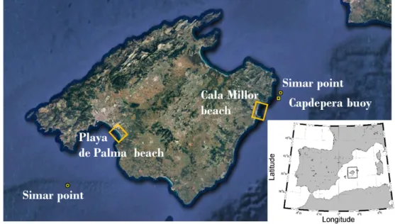
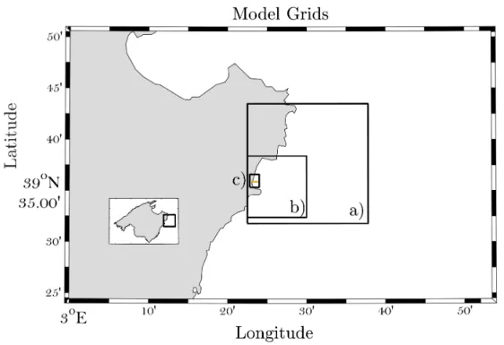
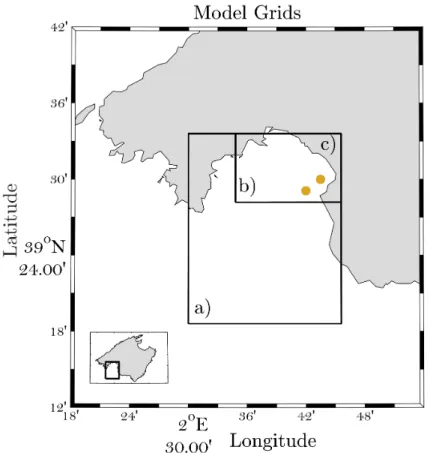
(45) Impacts of climate change on Balearic shores et al. 2015, Medellı́n et al. 2016). Here, in line with works in Villatoro et al. (2014), we address both effects. Furthermore, our study goes beyond the “bathtub” approach and takes into consideration the wave dynamic forces (as in, for example, Passeri et al. 2015, Plant et al. 2016, Gutierrez et al. 2011). To do so, we have used regional mean sea-level changes retrieved from global sea-level projections, with all the different contributions, in combination with regional wave projections over the western Mediterranean Sea up to the year 2100 under two different climate change scenarios. The paper is organized as follows. Section 2.2 is devoted to the description of the study areas, the characteristics of the wave climate, the data available and the numerical approach. The validation of the methodology, which includes the comparison between modelled and observed shallow water waves and coastline positions, is presented in Section 2.3. Section 2.4 describes the shoreline changes obtained under different climate change scenarios. Finally, a summary and some conclusions are presented in Section 2.5.. 2.2. Data and Methods. Cala Millor and Playa de Palma are two micro-tidal sandy beaches located in Mallorca island (Balearic Islands, western Mediterranean Sea; Figure 2.1). Cala Millor is 1.7 km alongshore by 35–40 m cross-shore, with a rock bed and a small cliff at the southernmost sector of the beach, and it is exposed to offshore waves from the NE to ESE. Both beaches are reflective, with the Playa de Palma slope being slightly steeper than Cala Millor. The wave regime in deep waters has a significant wave height (Hs) of 1 m and a peak period (Tp) of 4 s. Playa de Palma is 4 km alongshore by 30–50 m cross-shore and is exposed to offshore wave conditions from the SE to SW, with an Hs of 0.7 m and a Tp of 4.8 s. Figure 2.2 characterizes the mean wave regime offshore at both sites using selforganizing maps (SOMs) that have been built with a 58-year wave hindcast (see Section 2.2.5 for more details). SOMs graphically display the distribution of Hs, Tp and wave direction (in arrows). The results evidence that low-energy states are dominant at both sites and that, overall, Cala Millor is more energetic than Playa de Palma. These two beaches are considered urban beaches since they are backed by promenades and buildings; therefore, the beach responses to hydrodynamic changes are restricted by these features. Also, their aerial shape depends on the distribution of the sand that is carried out by the council workers according to the tourist comfortability. Playa de Palma and Cala Millor beaches have been part of the beach monitoring programme of the Balearic Islands Coastal Observing and Forecasting System (SOCIB) since 2011 (Tintoré et al. 2013). This programme includes periodic topography and bathymetry surveys, continuous video monitoring of the shoreline position and in situ measurements of nearshore waves and currents, among others. In addition, a dedicated 17.
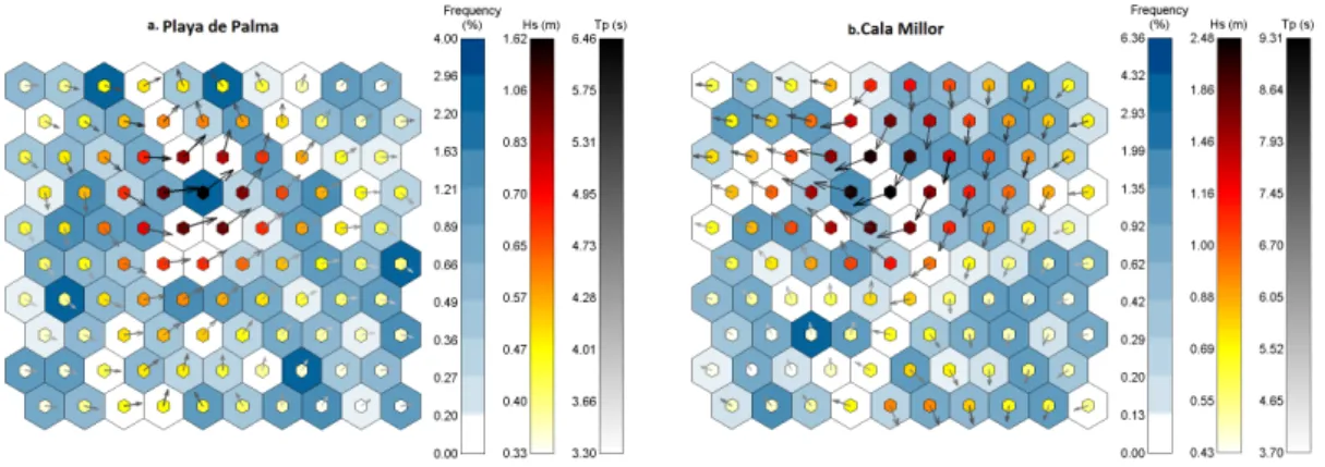
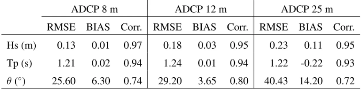
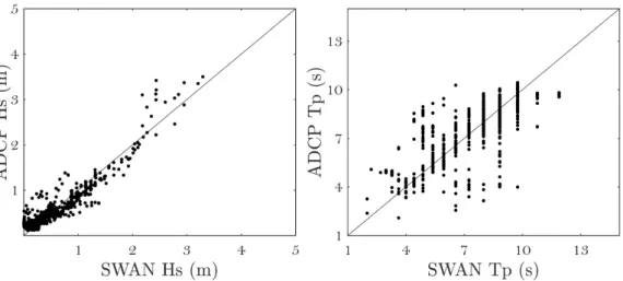
(46) Alejandra R. Enrı́quez. Figure 2.1 Mallorca island with Cala Millor and Playa de Palma beaches marked with yellow squares. SIMAR grid points used to characterize the offshore wave climate and the Capdepera wave buoy are also marked. The inset map represents the western Mediterranean basin. field survey (RISKBEACH) was undertaken in Cala Millor in March-April 2014, during which higher resolution observations were obtained (Morales-Márquez et al. 2017). Specific data used in the present work are described in the following. 2.2.1. Topo-bathymetric surveys. Bathymetry surveys were conducted using a single-beam echo sounder, BioSonics DT/DE Series Digital Echosounder, in the Cala Millor beach and a multi-beam echo sounder, R2Sonic2020, in Playa de Palma. The final spatial resolution is 1 m crossshore and 2 m alongshore in Cala Millor and 0.5 m x 0.5 m in Playa de Palma. These measurements were complemented with topographies of the aerial beach obtained using a survey-grade RTK-GPS (Real Time Kinematic Global Position System) mounted in a backpack carried by a human walker. These detailed beach topo-bathymetries were surveyed under calm conditions. 2.2.2. Hydrodynamic data. In Cala Millor, nearshore hydrodynamic data were obtained from three directional Acoustic Waves and Currents (AWACs) sensors located at 8, 12 and 25 m water depths; the AWACs were deployed as part of the RISKBEACH field survey, which covered 12 March to 14 April 2014. Offshore hourly hydrodynamic data have been recovered from Capdepera buoy, located 36.45 km northeast of Cala Millor at 48 m depth (see Figure 18.
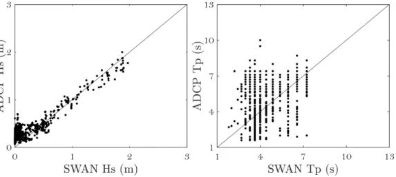
(47) Impacts of climate change on Balearic shores. Figure 2.2 Playa de Palma and Cala Millor self-organizing maps (SOMs). SIMAR databases are shown in 100 cells displaying the more representative deep water sea conditions at the Playa de Palma (a) and Cala Millor (b) beaches. The blue colour illustrates the frequency of the sea states, together with the Hs in metres (yellow to red), the period in seconds (white to black) and the direction in arrows. It can be seen that the more energetic conditions come from the SW in Playa de Palma and from the NE in Cala Millor, the higher frequency waves are also low-energy at both sites. 2.1 for location). The buoy has been operative during the period 1989-2014 as part of Puertos del Estado (the Spanish holding of harbours) buoys network. On the other hand, in Playa de Palma, wave data came from a coastal buoy located at 23 m depth and an acoustic Doppler current profiler (ADCP) deployed at 17 m depth, both operating since January 2012 as part of the SOCIB beach monitoring programme. 2.2.3. Video imagery data. Five and fourteen video cameras are used to measure the coastline position along Cala Millor and Playa de Palma beaches, respectively. These cameras are part of the video-based coastal zone monitoring system called SIRENA developed by SOCIB and IMEDEA (Mediterranean Institute of Advanced Studies). Departing from images taken at 7.5 Hz, the SIRENA system generates statistical products that provide quantitative information of hydrodynamics and morphodynamics after specific post-processing (Nieto et al. 2010). Specifically, the coastline is routinely obtained from the time image consisting of the addition of all images captured during 10 min (a total of 4500 images) and applying a post-processing of cluster classification. After applying different corrections to overcome the coarser resolution of the far-field camera images as well as rectifying the perspective projection, the coastline is georeferenced in a world coordinate system. The processing of camera images involves two types of errors related to the intrinsic and extrinsic calibrations. After images have been optically corrected, the extrinsic calibration relates pixel position with real-world coordinates, and thus errors are associated with the georeferencing (Simarro et al. 2017). Typically, resolution ranges between 0.5 and 2 pixels for Cala Millor and from 0.5 to 5 pixels for Playa de Palma. Conversely, 19.
(48) Alejandra R. Enrı́quez pixel resolution decreases with distance, but higher resolution (∼0.2 m) is obtained at the shore since cameras are oriented to measure this part at the centre of the image. Only pixels where errors are less than 3 m have been considered in this study. Exemplarily, the pixel resolution is added to Figure 2.15 in one area with the lowest radial resolution in Playa de Palma. 2.2.4. Numerical approach. With the aim of simulating the shoreline changes under given offshore conditions, the SWAN (Booij et al. 1999) and SWASH (Zijlema et al. 2011) models have been combined to resolve the wave processes from deep waters up to the swash zone. SWAN is a third-generation wave model that solves the spectral action balance equation for the propagation of wave spectra (http://swanmodel.sourceforge.net/). This model allows an accurate and computationally feasible simulation of waves in relatively large areas. On the other hand, SWASH is a phase-resolving non-hydrostatic model governed by the nonlinear shallow water equations with the addition of a vertical momentum equation and non-hydrostatic pressure in horizontal momentum equations (http: //swash.sourceforge.net/). Due to its computational cost, the application of SWASH is restricted to small areas. The combination of both models allows for high-resolution and accurate results with less computational cost. For the present study, SWAN simulations have been performed in a stationary mode over two regular nested grids. In Cala Millor, the coarser grid covers a domain of 21 km x 21 km, with its lowest left vertex at 39.53◦ N, 3.38◦ E (Figure 2.3) and a resolution of 149 m x 119 m in the x and y directions, respectively. The size of the finer grid is 9.5 km x 9.5 km, with its lowest left vertex at 39.6◦ N, 3.38◦ E and a resolution of 60 m. The coarse grid in Playa de Palma covers a domain of 21.5 km x 27.7 km, with its lowest left vertex at 39.31◦ N, 2.5◦ E (Figure 2.4) and a resolution of 100 m x 100 m in x and y directions. The domain of the finer grid is 13 km 10.8 km starting at 39.47◦ N, 2.58◦ E, with a resolution of 50 m x 50 m. In all cases, the SWAN output consisted of the 2-D variance energy density spectrum and the spectral parameters of propagated wave conditions. Each output SWAN spectra corresponded to 1 h of simulation and were used as the input wave conditions of SWASH. SWASH simulations in Cala Millor have been performed on a 1.5 km x 3.2 km rectangular grid, with its lowest left vertex at 39.57◦ N, 3.38◦ E, a resolution of 3 m x 3 m (Figure 2.3) and a maximum depth at 17 m. A larger SWASH domain was required in Playa de Palma, so a 3 m x 3 m grid covering a domain of 3 km x 7 km starting at 39.47◦ N, 2.75◦ E and tilted 45◦ in order to orient the wave maker boundary parallel to the beach, at 15 m depth, was used. The SWASH simulations lasted for 30 min, with a time step of 0.05 s to keep the Courant number between 0.01 and 0.5.. 20.
Figure
+7
Documento similar
1. S., III, 52, 1-3: Examinadas estas cosas por nosotros, sería apropiado a los lugares antes citados tratar lo contado en la historia sobre las Amazonas que había antiguamente
In addition to traffic and noise exposure data, the calculation method requires the following inputs: noise costs per day per person exposed to road traffic
In the previous sections we have shown how astronomical alignments and solar hierophanies – with a common interest in the solstices − were substantiated in the
While Russian nostalgia for the late-socialism of the Brezhnev era began only after the clear-cut rupture of 1991, nostalgia for the 1970s seems to have emerged in Algeria
The concept of breakdown probability profile is useful to describe the break- down properties of any estimate obtained through resampling, not just the bagged median or the
MD simulations in this and previous work has allowed us to propose a relation between the nature of the interactions at the interface and the observed properties of nanofluids:
Government policy varies between nations and this guidance sets out the need for balanced decision-making about ways of working, and the ongoing safety considerations
In this respect, a comparison with The Shadow of the Glen is very useful, since the text finished by Synge in 1904 can be considered a complex development of the opposition
