Report on
1:100 000 Scale Geological and Metallogenic Maps
Sheet 3366-22
Province of San Luis
John P. Sims and Roger G. Skirrow
GEOSCIENTIFIC MAPPING OF THE SIERRAS PAMPEANAS ARGENTINE-AUSTRALIAN COOPERATIVE PROJECT
AUSTRALIAN GEOLOGICAL SURVEY ORGANISATION
CONTENTS
Page
SECTION I: GEOLOGY ... 1
1. INTRODUCTION ... 1
1.1 Location and access ... 1
1.2 Nature of work ... 1
1.3 Previous investigations... 4
2. STRATIGRAPHY ... 5
2.1 General Relations ... 5
2.2 Palaeozoic Metamorphic Basement ... 7
2.2.1 Introduction ... 7
2.2.2 Cambrian ... 7
Nogoli Metamorphic Complex ... 7
2.2.3 Cambro-Ordovician ... 10
Pringles Metamorphic Complex... 10
2.2.4 Ordovician ... 11
San Luis Formation ... 11
2.2.5 Devonian ... 13
Río Guzman Shear Zone ... 13
2.3 Palaeozoic Igneous Rocks ... 14
2.3.1 Ordovician Intrusives ... 14
Undifferentiated granitoids and pegmatites ... 14
Tamboreo Granodiorite ... 15
2.3.2 Devonian Intrusives ... 16
San José del Morro Granite ... 16
Totora Granite ... 16
2.3.3 Minor Dyke rocks ... 17
2.4. Tertiary volcanics ... 19
San Luis Volcanic Group ... 19
2.5 Cainozoic ... 21
Unconsolidated cover ... 21
2.6 Quarternary ... 22
Unconsolidated deposits ... 22
3. TECTONICS ... 23
3.1 Pampean Cycle ... 23
3.2 Famatinian Cycle ... 25
3.3 Achalian Cycle ... 26
3.4 Andean Cycle ... 29
4. GEOMORPHOLOGY ... 30
5. GEOLOGICAL HISTORY ... 31
5.1 Early Cambrian sedimentation ... 31
5.2 Pampean Cycle ... 32
5.4 Famatinian Cycle ... 32
5.5 Achalian Cycle ... 33
5.6 Carboniferous - Permian sedimentation ... 34
5.7 Mesozoic sedimentation and magmatism ... 35
5.8 Andean Cycle ... 35
SECTION II: ECONOMIC GEOLOGY ... 36
1. INTRODUCTION ... 36
2. METALLIC MINERAL OCCURRENCES ... 38
2.1 W deposits of the La Florida - Pampa del Tamboreo districts ... 38
2.2 W deposits of the sierras de Los Morillos and Yulto ... 42
2.3 Pegmatite-hosted deposits of Be, Li ... 46
3. NON-METALLIC MINERAL OCCURRENCES ... 47
3.1 Mica, quartz, feldspar ... 47
BIBLIOGRAPHY ... 48
SECTION I: GEOLOGY
by John P. Sims1.
INTRODUCTION
1.1 LOCATION AND ACCESS
The 3366-22 map area forms an east-west transect within San Luis Province; ~46km by 40km between latitude 32°00’-33°20’ S and longitude 65°30’-66°00’ W. The area includes parts of two 1:250 000 scale map sheets: San Luis (3366-III), and Sierras de San Luis y Comechingones.
The area covers the southeastern Sierras de San Luis and western sierras del Yulto and Los Morillos and incorporates the minor population centres of La Toma, Saladillo, and Juan Llerena. The area is traversed by national route 148 and provincial routes 2, 10, 17 and 41, with the main drainage via Río Quinto, Río Rosario, Río Guzman, Río de la Cañada Honda and Arroyo Saladillo.
1.2 NATURE OF WORK
The mapping of the Sierras de San Luis was carried out in 1995 and 1996 under the
Topography, including cultural, hydrography and relief data were derived from existing 1:20 000 coverages where available. In areas where existing coverage was not available, culture and hydrography was derived from the rectified Landsat images, and the relief data was derived from the digital terrane model (DTM).
1.3 PREVIOUS INVESTIGATIONS
Previous regional geological mapping was at a scale of 1:200 000 and included
investigations by Pastore and Gonzalez (1954) of San Fransisco (Hoja 23g), Pastore and Huidobro (1952) of Saladillo (Hoja 24g), and Sosic (1964) of Sierra del Morro (Hoja 24h).
2.
STRATIGRAPHY
2.1 GENERAL RELATIONS
The Sierras Pampeanas are a distinct morphotectonic province of early- to mid-Palaeozoic metamorphic, felsic and mafic rocks that form a series of block-tilted, north-south oriented ranges separated by intermontane basins. These ranges are bounded by escarpments developed on moderate to steeply dipping reverse faults developed during the Cainozoic Andean uplift (Jordan and Allmendinger, 1986).
Recent geological and geophysical surveys conducted during the Cooperative Argentine-Australia Project in the Sierras Pampeanas show that the Paleozoic basement of the southern Sierras Pampeanas contains of a number of distinct lithological, structural and metamorphic domains separated by major tectonic zones. There are two principal domains: an older, Cambrian domain, and a slightly younger, Ordovician domain. Both domains share a common geological history since early Devonian times.
Rocks of the Cambrian domain in 3366-22 consist of the Conlara Metamorphic Complex. The Ordovician domain consists of Cambro-Ordovician rocks of the Pringles Metamorphic Complex and the Early Ordovician San Luis Formation. Several granitic, tonalitic, mafic and ultramafic bodies dominantly intrude the Ordovician domain. The Cambrian domain are intruded by voluminous Early Devonian granites and is partly covered by Neogene volcaniclastics. Both the Cambrian and Ordovician domains are partly covered by
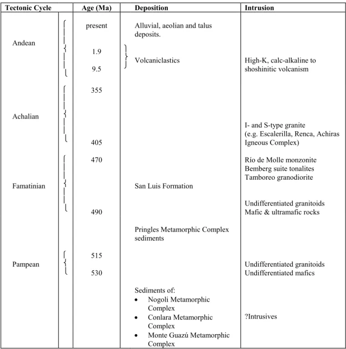
Table 1. Summary of the stratigraphy and age relations of the Sierras de San Luis y Comechingones (Sims and others, 1997) Age data and discussion of the various tectonic cycles are presented within the text. Some units are not represented on 3366-22.
Tectonic Cycle Age (Ma) Deposition Intrusion
Andean present 1.9 9.5
Alluvial, aeolian and talus deposits.
Volcaniclastics High-K, calc-alkaline to shoshinitic volcanism Achalian 355 405
I- and S-type granite
(e.g. Escalerilla, Renca, Achiras Igneous Complex) Famatinian 470 490
San Luis Formation
Río de Molle monzonite Bemberg suite tonalites Tamboreo granodiorite
Undifferentiated granitoids Mafic & ultramafic rocks
Pringles Metamorphic Complex sediments Pampean 515 530 Undifferentiated granitoids Undifferentiated mafics
Sediments of:
Nogoli Metamorphic Complex
Conlara Metamorphic Complex
Monte Guazú Metamorphic Complex
2.2 PALAEOZOIC METAMORPHIC BASEMENT
2.2.1 INTRODUCTION
The metamorphic basement of 3366-22 consists of four main subdivisions that relate directly to the geological ages of the units. The first subdivision represents basement rocks of at least Cambrian age (Conlara Metamorphic Complex) that were deformed and
metamorphosed during the late Cambrian, Pampean Tectonic-Cycle. The second
subdivision represents Cambro-Ordovician rocks of the Pringles Metamorphic Complex that were deposited prior to the onset of collisional tectonics associated with the
Famatinian Tectonic Cycle. The third subdivision are the low-grade rocks of the San Luis formation. These rocks were deposited very late in the Famatinian Cycle, probably during a late extensional phase, and display little evidence of the intense effects of that tectonic event. They are, however, intruded by early Ordovician tonalites and granodiorites, and display contact metamorphic aureoles as a result of those intrusions. The fourth
subdivision are represented by Devonian mylonite zones that formed during the Achalian Tectonic Cycle.
2.2.2 CAMBRIAN
Conlara Metamorphic Complex (–Ccgn, –Cce)
Pelitic and psammitic schist and gneiss; orthogneiss, minor calc-silicate and marble; pegmatite.
The Conlara Metamorphic Complex, comprises the majority of the basement outcropping within the valley (Valle del río de Conlara) between the Sierras de San Luis and Sierra de Comechingones. The Conlara Metamorphic Complex also incorporates the metamorphic part (the “Metamorfitas y Anatexítas India Muerta”) of a previously defined metamorphic-intrusive complex, the Achiras Complex (Otamendi and others, 1996), in the extreme south of the Sierra de Comechingones.
A significant proportion of the Complex is covered by a thin mantle of unconsolidated Cainozoic deposits, however, good exposures occur within Río Quinto, Río Rosario, Sierra del Yulto and Sierra Los Morillos.
The Conlara Metamorphic Complex comprises dominantly late Neoproterozoic - early Cambrian sediments intruded by Cambrian and/or early Ordovician granite and
polymetamorphosed in the early-mid Palaeozoic. The thickness of the sedimentary sequence is unknown due to the generally shallow orientation of the main transposition foliation. The Complex is intruded by a series of Devonian granites, which post-date the dominant structural and metamorphic episodes, and by Neogene calc-alkaline to shoshinitic volcanism. The Complex has a generally low magnetic signature and may be separated into regions that are comprised dominantly of gneiss, and areas comprised dominantly of schist.
Metapelitic and metapsammitic quartz-feldspar-biotite-muscovite-garnet-sillimanite ±tourmaline±chlorite schist is the most abundant rock type in the Conlara Metamorphic Complex (approximately 50%). The schist contains a well-developed biotite-muscovite foliation that is openly folded at a meso- to macro-scopic scale with long, generally shallowly east-dipping limbs and short, shallowly west-dipping limbs. Strongly corroded sillimanite, biotite coronas on garnet, and coarse poikiloblasts of muscovite and quartz containing tightly crenulated inclusions of sillimanite, suggest that the dominant fabric is a low temperature overprint of an earlier higher-grade (amphibolite-facies) fabric. Biotite and muscovite define a generally east plunging mineral lineation while shear-sense indicators are well developed and show a dominantly east-up displacement that is
consistent with the asymmetry of folding. An east-down shear-sense is locally preserved, however, particularly close to the western margin of the complex and where this fabric is associated with migmatitic shear bands and extensive pegmatites.
In places, the schist contains a metamorphic differentiated layering that consists of
alternating leucosome and millimetre-scale quartz-rich layers, and in the southern Sierra de Comechingones, contains minor interlayered tonalitic gneiss and banded ortho- and para-amphibolite. Within a kilometre of the Las Lajas Shear Zone in the southern Sierra de Comechingones, the schists are mylonitic and boudinaged, and chloritic alteration of biotite is common.
distinguished from the schist by the paucity of muscovite in the foliation, and more
massive outcrop style. Where secondary muscovite is developed, it is generally unoriented and a minor component of the mineral assemblage, or it is associated with discrete
overprinting shear bands, where it is associated with biotite. Leucocratic and/or pegmatitic veins are common in this rock type and typically define the main foliation, which is tightly to isoclinally folded (and refolded) at a meso- to micro-scopic scale.
Felsic orthogneiss is interlayered with both the gneiss and schist and constitutes a relatively minor component of the Complex. The orthogneiss is strongly foliated and consists
dominantly of equigranular quartz, feldspar and biotite with minor muscovite. The foliation in the orthogneiss appears to be contiguous with the earliest fabric in the
enclosing rocks and suggests that the original granite was emplaced during either the early Cambrian Pampean orogeny or Cambro-Ordorvician Famatinian orogeny.
Calc-silicate and marble are intimately associated and are a minor constituent of the complex, they are restricted to a series of narrow layers and pods through Sierra de Yulto, Sierra Los Morillos, Sierra del Morro and Sierra de la Estenzuela. Marble is subordinate and is predominantly calcite with minor quartz and diopside, while the calc-silicate assemblage includes hornblende, plagioclase, garnet, sphene, calcite and magnetite, with thin diopside coronas locally developed on garnet. Additionally, secondary veins crosscut the marble and calc-silicate and are associated with tungsten mineralisation, these include wollastonite-flourite-scheelite veins in Sierra los Morillos, and pegmatitic epidote-feldspar-amphibole-biotite-pyrite-calcite-magnetite-quartz veins in Sierra de Yulto. The magnetic susceptibility of the marble is generally low (<36 x 10-5 SI) while the calc-silicate produced
values up to 1231 (x 10-5) SI, and the late pegmatitic veins produced local values up to
3512 (x 10-5) SI.
Various generations of quartz-feldspar-biotite±muscovite±tourmaline±garnet pegmatite also occur within the Conlara Metamorphic Complex. Early generations are strongly deformed and are elongate and boudinaged in the schist and gneiss. Later generations are somewhat less deformed and are spatially associated with Devonian granites. The
2.2.3 CAMBRO–ORDOVICIAN
Pringles Metamorphic Complex (–COpgn, –COpe)
Pelitic and psammitic gneiss and schist, orthogneiss, amphibolite and pegmatite, minor calc-silicate
The Pringles Metamorphic Complex is exposed in the Sierras de San Luis, in three areas between the Conlara Metamorphic Complex in the east and the Nogoli Metamorphic Complex in the west. The easternmost and largest outcropping region occurs in a
continuous north-south belt dissecting the sierras. On 3366-22, the Pringles Metamorphic Complex only occurs in the northwestern most portion of the sheet, and is fault bound to the east by the San Luis Formation.
The Pringles Metamorphic Complex comprises metasediments of probable late Cambrian - early Ordovician depositional age intruded by early Ordovician mafic and ultramafic rocks of the Las Aguilas Group (c. 480 Ma), and by numerous granite and pegmatite bodies. Analysis of zircon separates from felsic orthogneiss (A95JS079e) and monazite separates from pelitic gneiss (A95JS129c) within the Pringles Metamorphic Complex suggest that the rocks reached a metamorphic peak at about the time of emplacement of the Las Aquilas Group, and had cooled to about 600 °C by about 450 Ma (Sims and others, 1997). The peak metamorphic grade in the rocks reached granulite facies, particularly in the region of the Las Aguilas Group intrusions. A close temporal relationship between the age of the Las Aguilas Suite and the peak metamorphism as well as the close spatial relationship, suggests that the ultramafic and mafic rocks may have been the heat source of the metamorphism.
The most abundant rock-types in the Pringles Metamorphic Complex are pelitic and semipelitic gneiss and pelitic and semipelitic schist. The gneiss represents domains where peak (granulite-facies) metamorphic assemblages have been preserved, whereas the schist either represents domains of initially lower grade (amphibolite-facies) metamorphism or regions where subsequent deformation has been localised and resulted in a lower grade metamorphic overprint. Only the schist is represented on 3366-22.
compositional layering that consists of alternating pelitic and semi-pelitic units is apparent in many areas of the schist that is not apparent in the higher grade regions of the complex.
Extensive tourmaline-apatite-garnet±beryl-bearing pegmatites occur within the schist and are associated with a number of S-type granite and leucogranite intrusions. These
intrusions occur in distinct belts within which, a locally intense, moderate to shallow, dominantly east-dipping shear fabric is developed, with east-down shear sense on a
moderately southeast plunging lineation. The shear fabric is mostly defined by muscovite-biotite±chlorite, while the lineation is locally defined by tourmaline. Many of the
pegmatites are strongly folded and boudinaged in this shear fabric. Within the metasediments, the earlier, peak foliation was strongly folded and transposed, and texturally the peak sillimanite is largely replaced by coarse poikolitic muscovite+quartz, and fine folia of muscovite. In places, late radiating needles of tourmaline and coarse, unoriented porphyroblasts of muscoviteare grown on the secondary foliation plane.
2.2.4 ORDOVICIAN
San Luis Formation (Osl, Osls, Oslc)
Phyllite, schist, arenite, slate and metaconglomerate
The San Luis Formation (Prozzi and Ramos 1988) occurs in two elongate NNE trending belts in the Sierras de San Luis. The eastern belt is les than 5 km wide and bound to the east by the Río Guzman Shear Zone and to the west by the Pringles Metamorphic
Complex. It is truncated to the north by the Las Chacras batholith and passes under shallow cover to the south. The western belt is no more than 3 km wide and passes through
Carolina and extends discontinuosly southwards on both the eastern and western margins of Escalerilla Granite (Sims and others, 1997). On 3366-22, the San Luis Formation is well exposed in Río de la Cañada Honda, in Río Quinto below Embalse La Florida.
The age of the San Luis Formation (SLF) is tightly controlled by structural and
Granodiorite. The contact of the SLF with the Pringles Metamorphic Complex and the Conlara Metamorphic Complex was strongly sheared during the Devonian, with kyanite, staurolite and garnet bearing assemblages and minor quartz-feldspar-muscovite-kyanite-staurolite pegmatites locally developed within the SLF near the contacts (Sims and others, 1997).
The majority of the SLF consists of medium- to thinly-bedded quartz arenite and phyllite in varying proportion, and include areas dominated by either lithology. Sedimentary
structures, such as graded bedding, cross-bedding, channel and flame structures, are common in areas where there is a higher proportion of coarser grained beds. Most rock-types are quartz-rich, and significant carbonate occurs in the matrix of some coarser grained arenites.
Two main deformations affected the SLF during the Devonian compressional cycle. The first of these deformations resulted in tight to isoclinal, upright to inclined folds with a well-developed, axial planar, slaty cleavage in most rock-types. The second deformation, resulted in the development of discrete shear zones, separated by domains of open
refolding with a corresponding crenulation cleavage. Additionally, a very early foliation is also preserved in fine grained rocks in some areas. The regional metamorphic grade within the SLF is typically lower greenschist and the rocks are generally fine grained. In places though, a more schistose and coarser grained fabric is developed, which probably reflects slight variations in the metamorphic grade, during the Devonian compressional cycle. Local high-temperature metamorphic aureoles are also developed around Ordovician, granodioritic to tonalitic intrusives. The magnetic signature of the San Luis formation is generally low, however, local high magnetic responses are developed in the region of magnetite-bearing Devonian mylonites such as the Río Guzman Shear Zone.
A distinctive, poorly-sorted, polymictic, conglomerate unit, named the Metaconglomerado Cañada Honda by Ortiz Suárez and others (1992), occurs within the SLF. The
conglomerate is up to 100 m thick and is well exposed in Río de la Cañada Honda. The conglomerate consists predominantly of angular clasts of pebble- to cobble-sized, quartzite and phyllite, within a fine- to coarse-grained matrix. Some larger clasts preserve primary bedding features. Ortiz Suárez and others (1992) have also reported the occurrence of clasts of rhyolitic to dacitic metavolcanics. Interlayered with the conglomerate are discontinuos, thin to medium sandstone and mudstone beds displaying channel structures and graded bedding. The top of the unit grades through alternating conglomerate and thinly bedded quartzite into thickly bedded massive quartzite units. An anastomosing mylonitic foliation is developed within the conglomerate parallel to bedding and most of the smaller quartzite clasts are recrystallised and display extensive sub-grain development. A sub-parallel cleavage is also developed on the mylonitic foliation and has resulted in a fine crenulation surface.
2.2.5 DEVONIAN
Río Guzman Shear Zone (Dzmi)
The Río Guzman Shear Zone is a linear north-northeast trending, high-strain zone, traversing the Sierras de San Luis from the Las Chacras batholith in the north, to near Saladillo in the south. The zone, which is up to 3 km wide, is a major lineament on aeromagnetic imagery that can be traced further to the south, beneath a thin cover of Cainozoic sediments. The shear zone, named after the Río Guzman, which follows the shear zone for several kilometres, has not previously been described. Rocks within the shear zone are mostly well exposed.
The shear zone consists predominantly of steeply east-dipping mylonite that separates the high-grade, Cambrian Conlara Metamorphic Complex from the low-grade, Ordovician San Luis Formation and is largely contained within the low-grade rocks. The dominant
east up displacement. The similarities of the kinematic indicators and metamorphic grade suggests a close temporal relationship with the Las Lajas Shear Zone in the Sierra de Comechingones.
Ar-Ar data from sericite in the mylonitic fabric, indicates a growth age between 360 and 350 Ma (Camacho and Ireland, 1997), which therefore constrains the minimum age of the greenschist-facies shearing. Additionally, the shear zone has been intruded by a number of undeformed lamprophyre dykes, and has been partly reactivated as an east dipping thrust during the presently active, Tertiary Andean compression.
2.3 PALAEOZOIC IGNEOUS ROCKS
2.3.1 ORDOVICIAN INTRUSIVES
Undifferentiated granitoids and pegmatite (Ogu, Opeg)
S-type leucogranite, granite, granodiorite, tonalite and pegmatite
This unit includes a distinctive suite of S-type granite, leucogranite and pegmatite that occur in an elongate NNE trending belt that passes through Embalse La Florida to the east of Trapiche. This group of rocks, which has previously been described as “granitoides sin-cinemáticos” by Ortiz Suárez and others (1992) and Llambías and others (1996a), is well exposed from Embalse La Florida through Paso del Rey and within Río Grande east of Siete Cajoles. On 3366-22, this unit is dominantly represented by extensive pegmatites that occur in the the northwestern portion of the sheet.
Structural constraints on the “granitoides sin-cinemáticos” suggest that the granites and pegmatites intruded a high-grade (amphibolite facies) basement. Previous geochronology by Linares (1959) and Llambías and others (1991) indicates that the pegmatites associated with these rocks were emplaced prior to 460 Ma.
extremely coarse grained, feldspar-quartz-muscovite-tourmaline-garnet-apatite bearing varieties that are typically compositionally zoned.
The “granitoides sin-cinemáticos” are spatially associated with zones of extensional deformation developed late in the Famatinian tectonic cycle. They are spatially associated with pervasive retrogression of the high-grade assemblages within the Pringles
Metamorphic Complex and development of a muscovite-tourmaline-bearing assemblages at the expense of sillimanite-biotite-bearing assemblages. Complex interference folds defined by pegmatites of this suite suggests multiple deformation episodes. Llambías and others (1996a) have estimated that the initial deformation within the granites developed under amphibolite-facies conditions, whilst open refolding is consistent with the initial upright folding of the San Luis formation under greenshist-facies conditions.
Tamboreo Granodiorite (Ogdt)
The Tamboreo Granodiorite forms a slightly elevated plateau ~3 km wide by ~6km long, called Pampa del Tamboreo, which is ~5km to the northeast of Embalse La Florida. Detailed studies of the pluton have been carried out by Zardini (1966) and Sato and others (1996). These previous studies referred to this pluton as the Tamboreo Tonalite.
The granodiorite intrudes the San Luis Formation and has a distinct metamorphic aureole on the eastern margin. The western margin, however, is strongly sheared and in contact with schist of the Pringles Metamorphic Complex. The granodiorite is intruded by north-south trending aplitic to rhyolitic dykes. U/Pb geochronology of zircon separates has produced an early Ordovician age of 470 ± 5 Ma (Camacho and Ireland, 1997).
The granodiorite is grey to pink in outcrop, and contains a low proportion of mafic xenoliths, which are elongate parallel to a locally well-developed foliation (Sato and others, 1996) defined by biotite. K-feldspar proportions range from 1.5% (Sato and others, 1996) to 25% (Sims and others, 1996), which suggests that there is either a strong
magnetic susceptibility was 25 x10-5 SI. The composition and age of the pluton suggest it is closely related to the Bemberg Suite tonalites (Sims and others, 1997)
2.3.2 DEVONIAN INTRUSIVES
San José del Morro Granite (Dgm)
The San José del Morro granite is exposed over approximately 60 km2 in the north of the Sierra de Yulto. Aeromagnetic images show the pluton is semi-ovoid in shape and more extensive than is outcropping. To the westof the exposed area, approximately 40 km2 is covered by fault bounded Cainozoic sediments.
The granite intrudes the Conlara Metamorphic Complex and K/Ar ages indicate that the granite was emplaced between 390-360 Ma (Lema, 1980). The granite is strongly foliated on the NW margin and generally has a moderately well developed mineral alignment.
The granite is moderately magnetic, pink to red, strongly jointed and consists of equigranular and porphyritic phases. Compositionally the granite ranges from
monzogranite to syenogranite and has a metaluminous character (Quenardelle, 1993) The granite consists of predominantly porphyritic K-feldspar (microcline), plagioclase, quartz, with abundant biotite and minor titanite. Quenardelle (1993) also reports trace apatite, magnetite, ilmenite and zircon. Locally, the granite contains numerous mafic enclaves and xenoliths of the country rock. A number of large rafts of basement rock, suggest the pluton may be only shallowly exposed. Numerous pegmatites and aplite dykes intrude the country rock on the margin of the granite and cross-cut the large basement rafts. Additionally, minor, shallowly worked, skarn mineralisation occurs in calc-silicate and marble units adjacent to the pluton.
Totora Granite (Dgtl, Dgte, Dgti)
well exposed in low platforms along provincial route 20. The name of the granite derives from the small town of La Totora which is located on the pluton.
The granite intrudes the basement rocks of the Conlara Metamorphic Complex and truncates the main structural fabric in those rocks. Aeromagnetic data suggests that the granite continues under shallow cover to the southeast. Though there is no isotopic data for this pluton, the shape and magnetic zonation of the pluton and the absence of a marked tectonic overprint suggests that this granite is Devonian in age.
The pluton is grey to pink in outcrop and consists predominantly of K-feldspar, quartz and plagioclase, with minor mafic enclaves. Photographic and magnetic imagery as well as petrography, suggests the granite consists of three phases: a main, to very coarse-grained, sub-equigranular phase that is moderately magnetic (average magnetic
susceptibility of 972 x 10-5 SI) and strongly jointed in outcrop, a thin leucocratic border
phase that occurs on the western margin and is not jointed, and an inner porphyritic and slightly-less-magnetic phase (average magnetic susceptibility of 721 x 10-5 SI). Biotite
comprises approximately 5% of the total rock in the main and inner phase and is partially replaced by chlorite, while accesory phases include magnetite, sphene and garnet. The K-feldspar is microcline and is partially replaced by muscovite, while plagioclase displays myrmekitic grain boundaries. The inner phase of the pluton contains significantly more plagioclase than the main phase (20% c.f. 10%) and is also weakly foliated.
2.3.3 MINOR DYKE ROCKS
Pegmatite (peg)
Numerous pegmatite dykes intrude the basement of 3366-22. There are essentially four mainsubdivisions:
1. Pegmatites emplaced during M1 metamorphic peakin the Middle Cambrian, at around 530-515 Ma. These are restricted to within the Conlara Metamorphic Complex on 3366-22.
3. Pegmatites emplaced post-M2 in the mid Ordovician prior to 460Ma, and associated with the undifferentiated Ordovician granites.
4. Pegmatites emplaced during the Devonian,and associated with the extensive granite bodies.
Aplite
A group of thin aplite dykes that are wholly contained within the San Luis Formation and intrusives within those rocks, occur in the Sierras de San Luis. These dykes are up to 5 km in length and no more than 3 m in width. They cross-cut the Tamboreo granodiorite and are folded and recrystallised. A minimum age for for the dykes is provided by Devonian ages for the deformation of the San Luis formation. The dykes consist of medium-grained phenocrysts of quartz, feldspar, garnet and muscovite, in a fine grained recrystallised matrix, with minor secondary zoisite. Limited geochemistry from Sato and others (1996) indicates that the dykes are granitic in composition. Brodtkorb and others (1984) have interpreted some of these dykes, that occur within the San Luis Formation as
metavolcanics.
Lamprophyre
A number of thin lamprophyre (minette) dykes have been observed within and adjacent to the Río Guzman Shear Zone in the Sierras de San Luis. These dykes are no more than 1 m in width and consist almost entirely of medium-grained biotite. Within the shear zone, the dykes have intruded parallel to the mylonitic foliation but are not deformed.
2.4 TERTIARY VOLCANICS
San Luis Volcanic Group (Tvp)
Pyroclastic and epiclastic volcanic deposits
A series of volcanic centres occur in a northwest-southeast trending belt of approximately 90 km length through central and western Sierras de San Luis y Comechingones. The volcanic centres include Sierra del Morro in the southeast, cerros Rosario and Tiporco, Cerros Largos, Cañada Honda, and La Carolina in the northwest, and range from late Miocene (~9.5 Ma) to Pliocene (~1.9 Ma) in age. The geology, petrography and
geochemistry of the volcanics have been examined by Brogioni (1987b, 1990). A general description of the volcanic centres is presented in Table 2. Only minor volcaniclastic deposits occur on 3366-22.
The volcanic rocks, called here the San Luis Volcanic Group, range from late Miocene (~9.5 Ma) to Pliocene (~1.9 Ma) in age and are intrusive into the Conlara and Pringles metamorphic complexes and the San Luis Formation. Associated pyroclastic and epiclastic deposits form aprons around the volcanic centres and have been variously reworked or eroded. The intrusive volcanic rocks have a high reversely magnetised signature and highly potassic radiometric signature. Magnetic susceptibilities of the intrusive volcanics are generally in the range of 1000 – 3000 x 10-5 SI, while the pyroclastics are generally in
Table 2. Volcanic centres, age and general descriptions. References for age
determinations: 1 Ramos and others (1991); 2 Urbina and others (1995); 3 Sruoga and others (1996).
Volcanic centre
(dating location) Age (Ma) (K/Ar) Rock-types and general description
La Carolina
(Tres Cerritos) (C° Tomolasta) (C° Pan de
Azucar) (not specified)
8.2 ± 0.43
7.5 ± 0.42
7.3 ± 0.42
6.3 ± 0.33
Range of volcanic plugs and domes, minor pyroclastic deposits and subvolcanic breccias. Extensive alteration of host rocks. Basement deeply eroded (~300m?). NW trending faults
Cañada Honda
(Diente Verde) 9.5 ± 0.52
Range of volcanic plugs and domes. Extensive alteration of host rocks. Basement deeply eroded (~200m?)
Cerros Largos Volcanic domes. Tuff mostly preserved in topographic low (?diatreme) to SW of volcanic domes. Basement eroded (~100m?)
Tiporco Single isolated volcanic dome in raised (~50m) basement ring. Travertine and subsurface veins of calcareous onyx encircle the volcanic centre. Paleao landsurface readily apparent, however, much of the pyroclastic material has been removed
Cerros del Rosario 2.6 ± 0.61 Range of volcanic plugs and domes partly centred
in raised (~200m) basement ring. Paleao
landsurface readily apparent, however, much of the pyroclastic material has been removed. Ring faults around basement dome
Sierra del Morro
(not specified) (not specified) (not specified)
6.4 ± 0.61
2.6 ± 0.61
1.9 ± 0.21
Range of volcanic plugs and domes, breccia pipes and dykes mostly contained within domed (~700m) basement rocks with a central collapsed(?) caldera. Palaeo landsurface readily apparent with thick cover of pyroclastic and epiclastic material preserved on the north, east and south flanks. Western flank deeply dissected (~200m) adjacent to Los Morillos fault escarpment. ‘Box’ faults around basement dome.
to metres in thickness and consist of a combination of pumice, ash and lithic fragments. The beds include ground surge deposits, ash fall tuff and fragmental tuff. Welded
pyroclastic breccia was also observed adjacent to Cerro Tiporco. Bombs of both basement and volcanic material are common in the pyroclastics. Epiclastic deposits are well
developed in the region of Sierra del Morro, where they form resistant radial fans with inverted relief around the main basement dome.
2.5 CAINOZOIC
Unconsolidated cover (Czu, Czg, Czc, Czd)
Loess, alluvial deposits, fans, gravels, caliche,channel deposits etc.
Unconsolidated alluvial, colluvial and aeolian deposits, as well as palaeosols, overly the basement rocks in Sierras de San Luis y Comechingones and are interspersed with some of the volcaniclastic deposits. The most extensive Cainozoic unit (labelled Czu) is an
intercalted sequence of undifferentiated Tertiary to Quaternary fluvial and aeolian deposits and paleosols that cover a large part of the Pampean region. In areas of low lying relief, these deposits cover all older units and forms a mantle or rarely dune fields between the main Pampean ranges. The undifferentiated Cainoizoic deposits comprise mostly friable illite and silt, with material derived from both the metamorphic-igneous basement rocks and a volcanic-pyroclastic source (Strasser and others, 1996). Strasser and others (1996) have correlated the stratigraphically younger deposits in the San Luis region with Late Pleistocene and Holocene units in the Buenos Aires Province.
In places, paleosols (labelled Czc), typically with a hardpan of calcrete, form thin (a few metres thick) remnant cappings over basement rocks. They are best exposed along the gently sloping eastern flanks of the Sierras de Comechingones and in the easternmost Sierras de San Luis where they are overlain by intercalated Tertiary to Quaternary fluvial and aeolian deposits. The age of the deposits is not known. Their formation predates the last significant uplift which probably took place during the Late Pliocene-Pleistocene (Costa, 1996).
Raised fluvial and colluvial fan deposits of unconsolidated gravels (labelled Czg) form low, wooded, dissected hills at the base of many of the main Cainozoic fault scarps. The most extensive of these occur along the western scarp of the Sierras de San Luis. These deposits are correlated with similar Pleistocene (Quaternary level 1 subdivision of
exposure of Miocene-Pliocene volcanic plugs from east to west places a lower age constraint on the earliest uplift and hence the maximum age of the fans at mid-Pliocene.
2.6 QUATERNARY
Unconsolidated deposits (Qa, Qg, Qs, Qt)
Active alluvial deposits, fans, gravels, talus.
3.
TECTONICS
Three major deformation, metamorphic and magmatic events have affected the basement
rocks of Sierras de San Luis y Comechingones (Table 1). Rocks of the Monte Guazú,
Conlara and Nogoli metamorphic complexes preserve evidence of the earliest event, while
the latter two are present within the rocks of the Pringles Metamorphic Complex. The San
Luis Formation only shows effects of the latest event. The three tectonic events are termed
here the (Early Cambrian) Pampean Cycle, the (early Ordovician) Famatinian Cycle, and
the (Devonian) Achalian Cycle. All regions were also affected by reverse faulting and
block-tilting during the Cainozoic Andean Cycle.
3.1 PAMPEAN CYCLE: EARLY CAMBRIAN DEFORMATION AND METAMORPHISM
The oldest preserved structural feature in Sierras de San Luis y Comechingones is a
medium- to high-grade metamorphic differentiated foliation which is well-preserved in
pelitic gneiss and amphibolite of the Monte Guazú, Conlara and Nogoli metamorphic
complexes. The foliation (S1), which is variably developed, is typically a penetrative
gneissic foliation in pelitic gneiss, defined by leucosome lenses and a mineralogical
layering defined by biotite, quartz and sillimanite with a lineation (L1) defined by
sillimanite and quartz. In tonalitic orthogneiss, aligned biotite forms S1 folia, with a weak
biotite and quartz lineation. In amphibolite and calcsilicate rocks the foliation forms
strongly differentiated mineralogical bands with aligned hornblende. Throughout most of
the Monte Guazú Metamorphic Complex the S1 foliation, trends NNW and dips ~45° to
the east. The trend of the S1 foliation in the Conlara and Nogoli metamorphic complexes
is generally similar, however, the dip of the foliation is more variable due to locally intense
reworking during subsequent events. No kinematic indicators where observed.
Sillimanite-garnet assemblages in pelitic gneiss indicate M1 metamorphism was at least
amphibolite facies and abundant muscovite-pegmatites, and leucosome (forming
subconcordant lenses with S1) suggest limited partial melting took place.
Metamorphic Complex in the Sierra de Comechingones range from 6.1 to 9.5 Kb, at 700 to
800 °C (Cordillo, 1984; Martino and others, 1994; Cerredo, 1996). No P–T estimates exist
for the Conlara or Nogoli metamorphic complexes, however, peak metamorphic
assemblages in the Nogoli Metamorphic Complex of cordierite-garnet-sillimanite in pelitic
rocks, and an apparent scarcity of orthopyroxene in metamafic rocks, suggests pressures of
<~7 Kbars at temperatures of no more than ~750°C (e.g. Grant, 1985; Spear, 1981, 1993).
No isotopic data exist from Sierras de San Luis y Comechingones to constrain the age of
the Pampean Cycle. However, uranium-lead dating of zircon and monazite from Córdoba
(Sierras de Septentrionales), which grew during M1 (Lyons and Stuart-Smith, 1997), give
an age of ~530Ma (Camacho and Ireland, 1997). Late Pampean granites in Córdoba give
ages of ~515-520 Ma (Camacho and Ireland, 1997; Rapela and Pankhurst, 1996;
3.2 FAMATINIAN CYCLE: ORDOVICIAN DEFORMATION AND METAMORPHISM
Formation of a basin, in which the sedimentary protolith to the Pringles Metamorphic
Complex was deposited, possibly marks the initiation of a subduction complex to the west
of the Sierras de San Luis in the late Cambrian. Numerous intrusives within the La Rioja
area that were emplaced around 490-480 Ma (Camacho and Ireland, 1997) probably
represent the core of the associated volcanic arc (Pieters and others, 1997). Correlatives of
these intrusives within Sierras de San Luis y Comechingones, are represented by
monzonites and quartz-monzonites (e.g., the Río del Molle Monzonite) emplaced into the
Nogoli Metamorphic Complex. The back-arc basin had closed, however, by the early
Ordovician, when the Cambro-Ordovician rocks were strongly deformed and intruded by
syn-kinematic mafic and ultramafic rocks of the Las Aguilas Group (LAG) at ~480 Ma
(Camacho and Ireland, 1997).
Compressional phase
The peak metamorphic assemblages in the Pringles Metamorphic Complex, which formed
under granulite facies conditions during the Famatinian Cycle, are spatially located in an
elongate belt around the LAG. The pelitic rocks contain a gneissic fabric defined by
sillimanite and biotite (S1 in the Pringles Metamorphic Complex but regional S2), with
lenses and pods of cordierite- and garnet-bearing leucosomes. The gneissic layering trends
N-NNE and dips mostly steeply to the east, and sillimanite and biotite laths define a steeply
plunging mineral lineation. A number of discrete mylonite zones are formed within the
complex, these are generally less than 20-30 m wide and parallel the gneissic layering.
High-grade assemblages involving sillimanite and locally cordierite in the mylonites and a
stretching lineation parallel to that in the gneiss suggest they formed synchronously. The
mylonites are particularly well developed along the margins of the ultramafic bodies.
Shear sense indicators both in the gneissic layering and in the mylonites and give an
east-up displacement sense.
In gneiss and schist of the Conlara Metamorphic Complex a schistosity parallel to S1 forms
the main penetrative structure. All S1 fabrics are rotated into parallelism forming a new S2
amphibolite/upper greenschist facies metamorphism (M2) is indicated. Quartz-feldspar
leucosome, formed during M1, are deformed into asymmetrical clasts indicating
westward-directed thrusting.
Extensional phase
By ~470 Ma the compressional regime had ceased and the terrane was in extension,
resulting in deposition of the San Luis Formation (SLF). This was followed subsequently
by intrusion of the Tamboreo Granodiorite and tonalites of the Bemberg Suite, which
produced metamorphic aureoles in the cover rocks.
The extensional structures developed under greenschist-facies conditions, and deformation
was partitioned into domains of shearing with a shallow to steep, east to southeasterly
dipping lineation and domains of open to tight folding of the older structural surfaces in the
basement rocks. Shear fabrics defined by muscovite ± biotite predominate, with a
lineation locally defined by tourmaline. Shear sense indicators give an east-down
displacement sense. Numerous pegmatites and (fractionated) granites intruded
synchronously with the deformation and show varying degress of folding and dynamic
recrystallisation. A U-Pb uraninite age of ~460 Ma has been derived from one of these
pegmatites (Linares, 1959).
3.3 ACHALIAN CYCLE: DEVONIAN DEFORMATION AND RETROGRESSION
Throughout much of the region, the medium- to high-grade Pampean (D1) and Famatinian
(D2) fabric elements are mostly rotated into parallelism by a shallowly- to
moderately-dipping, penetrative shear fabric associated with a prolonged collisional episode, termed
the Achalian Cycle (Sims and others, 1997). This episode is marked by the development of
mylonite in high-strain zones and pervasive, retrogressive greenschist-facies
metamorphism and the emplacement of voluminous granite plutons. To varying degrees,
the deformation affects all basement rocks, and is probably the the most significant single
Deformation in the Achalian Cycle involved repeated partitioning of strain between zones
of thrusting and zones of strike slip displacement, with repeated overprinting relationships.
Domains between shearing were folded and refolded; in some places producing basin and
dome interference folds. Strain was focussed in a number of major mylonite zones, in
particular, in the northwest-trending Las Lajas Shear Zone, which truncates the Conlara
Metamorphic Complex, north of Achiras; and in the north-northeast trending Río Guzman
Shear Zone, which separates the Conlara Metamorphic Complex from the San Luis
Formation. Additionally, a number of significant mylonite zones developed, including one
along the eastern flank of the Sierra de Comechingones, passing through Las Albahacas,
and a complex zone that follows the eastern contact of the Escalerilla Granite in the Sierras
de San Luis. These deformations have been previously incorporated within the Famatinian
Cycle (e.g. von Gosen and Prozzi, 1996)
At least 4 distinct styles of deformation are recognised within the Achalian Cycle (Sims
and others, 1997). These styles are in part an effect of the partitioning of strain but also an
effect of changing stress or metamorphic conditions in the terrane through the tectonic
cycle.
1. Pervasive mylonitic foliation and tight to isoclinal folding
The earliest structural element is a pervasive mylonitic foliation associated with thrusting
under upper greenschist-facies conditions. Interference with flat-lying folds in both the
Pringles and Conlara metamorphic complexes produced open basin and dome
fold-interference patterns. In the early Ordovician San Luis Formation, tight to isoclinal folds
are developed in bedding with an axial planar slaty cleavage (S1 in the SLF but regional
S3) developed between major shear zones. A maximum age for this early fabric forming
event is provided by a 403 ± 6 Ma age (U/Pb zircon; Camacho and Ireland, 1997) for the
Escalerilla granite which is affected by the early tectonism. Kinematic indicators including
asymmetric mantled porphyroclasts and S-C fabrics all indicate westward-directed
2. Ductile strike-slip shearing
Discrete sinistral shear-zones up to 50m wide are developed in a number of areas within
the Sierras de San Luis. The shear zones contain a mylonitic fabric with a sub-horizontal
mineral and elongation lineation and well developed shear sense indicators. Argon-argon
dating (Camacho, 1997) suggests that a change in the regional stress field corresponding to
development of ductile strike-slip shearing may have occurred in the Middle Devonian
(Sims and others, 1997).
3. Thrusting at low-grade in discrete shear zones with contemporaeous folding and
crenulation of the earlier mylonitic fabric
Overprinting the strike-slip shear-zones are a number of major low-grade shear-zones that
traverse both the Sierras de San Luis (Río Guzman Shear Zone) and the Sierras de
Comechingones (Las Lajas Shear Zone and Las Albahacas Shear Zone). These shear zones
are up to several kilometres in width, and contain greenschist-facies mineral fabrics that
show east-up shear-sense on an easterly plunging lineation, parallel to the early L3 fabric.
A regional crenulation cleavage associated with north-south trending open folding is
considered to be have developed contemporaneously between the main shear-zones.
4. Brittle-ductile strike-slip faulting typically in conjugate sets trending NW and SW
A complex system of rectilinear brittle vertical WNW- and ENE-trending strike-slip faults,
breccia zones and fractures (von Gosen and Prozzi, 1996) affect all the basement units in
the Sierras de San Luis and the Sierra de Comechingones, in places displacing the S3
mylonitic foliations and related folds. The faults are rarely exposed, but are prominent on
aerial photographs and Landsat images. Some of the faults are also delineated on magnetic
images as low magnetic zones owing to magnetite destruction. Within the Sierras de San
Luis, where exposed, these faults typically consist of narrow zones (<1 m wide) of
brittle-ductile mylonite and minor ultramylonite. Fault mineral assemblages include quartz,
sericite, epidote, hematite, goethite and chlorite.
The orientation and conjugate relationship of the WNW- and NE-trending strike-slip faults,
regime that accompanied S3 and S4 development. This fracture system is developed
throughout the Sierras Pampeanas and in Córdoba and La Rioja Provinces. Ar-Ar ages of
hydrothermal white micas in the fault zones, in places associated with Au mineralised
quartz veins, indicate that this stage began about 385 Ma, peaked at 370 Ma and continued
until 355 Ma (Skirrow, 1997b, c).
3.4 ANDEAN CYCLE: REVERSE FAULTING
Tectonism associated with the collision of the Nazca and South American plates resulted in
a period of extensional deformation in the Sierras Pampeanas region during the Neogene,
followed by compression from the late Neogene through to the present. The extensional
phase resulted in the development of a number of small southeast – northwest trending
basins. Also during this period, high-K calc-alkaline to shoshonitic volcanics were
emplaced in a ~80 km belt, parallel to the extensional basins, from Sierra del Morro to La
Carolina,.
A marked change in the regional stress field occurred after the mid-Pliocene, coincident
with the cessation of volcanism. Since that time, the Sierras Pampeanas region has been in
a compressional regime and the Sierras de San Luis and Sierra de Comechingones are
examples of the uplift on basement thrusts that have formed during this period (e.g., Costa
and Vita-Frinzi, 1996). The ranges slope gently to the east and are bounded to the west by
escarpments developed on low to moderate angle, east dipping, reverse faults. In the Sierra
Comechingones, a major north-south fault zone, the Comechingones Fault (Costa and
others, 1994), extends along the base of the western escarpment, and can be traced on
aeromagnetic images to the south of La Punilla, beneath a veneer of Cainozoic sediments.
14C ages suggest the fault was active as recently as c. 1000 years ago (Costa and
4.
GEOMORPHOLOGY
The uplift during the Late Cainozoic of peneplanated crystalline basement on reverse
faults, generally trending north-south, produced a series of tilt blocks throughout the
Sierras Pampeanas (Jordan and Allmendinger, 1986). The asymmetry of the basement
blocks is produced by the formation of steep escarpments on the bounding fault side and
gentle slopes, the dissected peneplanated surface, on the other. Broad flat valleys between
major blocks are depositional centres filled with a variety of Cainozoic and Quaternary
sediments including aeolian, fluvial, and lacustrine material.
The region encompassing the sheet area is comprised of three main physiographic domains:
the Sierras de San Luis in the west, the Sierra de Comechingones in the east, and the
Conlara Valley in the centre which includes a number of minor ranges and the uplifted
basement around the volcanic centre of Sierra del Morro. The principal faults along which
uplift occurred are the San Luis and Comechingones Faults which dip to the east. The fault
scarps are on the western side of the main sierras and the dissected peneplanated surfaces
slope to the east. The broad depositional basin of the Conlara Valley contains the smaller
tilt blocks of the Sierras de La Estanzuela, de Tilisarao, del Portezuelo, San Félipe, and del
Yulto. The Sierra del Morro is a broad cone of uplifted basement resulting from the
intrusion of the volcanic centre.
The Conlara Valley is filled with Cainozoic alluvial, aeolian, and volcanogenic deposits
which preserve an earlier Cainozoic surface evidenced by the presence of palaeo-channels
found away from present day watercourses. The intermontane deposits in the west of the
sheet area are characterised by Quaternary gravels shed from the Sierras de San Luis.
The main drainage from the Sierras de San Luis is via the Río Quinto to the south east,
which flows in to the Conlara Valley, and the Río Chorillos to the south west. The Sierras
de Comechingones are drained by the east-south east flowing Río Cuarto. The Conlara
Valley is drained by the north-north east flowing Río Conlara and the southward flowing
5.
GEOLOGICAL HISTORY
The Sierras de San Luis y Comechingones area forms part of the southern Sierras
Pampeanas, comprising basement ranges of Neoproterozoic to early Palaeozoic
metamorphic rocks and Palaeozoic granitoids, separated by intermontane Cainozoic
sediments. The basement rocks form a series of north-trending lithological and structural
domains separated by major mid-crustal shear zones. These domains have been variously
interpreted to form originally part of an ensialic mobile belt (e.g. Dalla Salda, 1987) or as
terranes that either accreted, or developed on a western convergent margin of the Río Plata
craton (e.g. Ramos, 1988; Demange and others, 1993; Escayola and others, 1996, Kraemer
and others, 1995, 1996). Recent geochronological studies (e.g. Camacho and Ireland,
1997) and the geological relationships, indicate that there are two principal domains in the
southern Sierras Pampeanas: an older Cambrian domain, and a younger Cambro–
Ordovician domain. Both domains share a common tectonic history since early Devonian
times.
5.1 EARLY CAMBRIAN SEDIMENTATION
The oldest rocks in the region form a structurally thick sequence of pelitic and lesser
psammitic gniesses which comprise the Valle de la Río Conlara and the Sierra de
Comechingones (Conlara and Monte Guazú metamorphic complexes), as well as an
orthogneiss dominated terrane with minor pelitic gneiss (the Nogoli Metamorphic
Complex) in the western Sierras de San Luis. No original sedimentary structures, such as
bedding, can be recognised in these metamorphic rocks. Minor marbles are common in the
eastern complexes of the Sierras de San Luis y Comechingones but are less extensive than
in interpreted extensions of the same domains in northern Córdoba (Lyons and others,
1997), where they form semi-continuous belts. These metasediments are interpreted as
being deposited on a passive margin, developed during intracontinental rifting and breakup
of Laurentia from Gondwana in Eocambrian times at about 540 Ma (Dalziel and others,
5.2 PAMPEAN CYCLE
Early Cambrian deformation, metamorphism, mafic and felsic intrusion
Following intrusion of tholeiitic mafic dykes, the sediments were deformed at mid-crustal
levels by a compressive event (D1) and metamorphosed at mostly upper amphibolite facies
and locally, granulite-facies. Uranium-lead dating of zircon rims and monazite formed
during this metamorphic event (M1) in Córdoba give an age of ~530 Ma (Lyons and
others, 1997; Camacho and Ireland, 1997). The deformation is interpreted as the first in a
series of deformation events associated with convergence on the newly created Pacific
Gondwana margin formed after final amalgamation of the supercontinent (e.g. Dalziel and
others, 1994).
At the closing stages of the Pampean Cycle, an extensive phase of felsic magmatism is
evident by widespread subconcordant intrusion of tonalite, granodiorite and granite within
the Monte Guazú Metamorphic Complex. There are no radiometric dates on these
intrusions although similar intrusions in the Sierra Norte - Ascochinga area in Córdoba
have been dated at ~515 Ma (AGSO - Subsecretaría de Minería, unpublished U-Pb zircon
data).
5.3 EARLY PALAEOZOIC TUBIDITE SEDIMENTATION
Continental and arc derived pelitic turbidites were deposited in a probable back arc basin
setting along the Pampean margin in the early Palaeozoic. Remnants of this back arc basin
form the protoliths to the Pringles Metamorphic Complex in the Sierras de San Luis.
5.4 FAMATINIAN CYCLE
Early Ordovician deformation, metamorphism, mafic and felsic intrusion
During the Ordovician, closure of the Iapetus Ocean and collision of the Precordillera with
the Pampean margin of the Gondwana craton (Dalla Salda and others, 1992, 1996; Dalziel
and others, 1996) resulted in amalgamation of the Cambro-Ordovician back arc (Pringles
metamorphic and magmatic event known as the “Ciclo orogénico Famatiniano”
(Aceñolaza and Toselli, 1976), Famatinian Orogen (eg. Dalla Salda and others, 1992) or
“Ciclo Famatiniano” (Dalla Salda, 1987). The compressive deformation (D1 in the
Cambro-Ordovician rocks, D2 in the Cambrian rocks), which occurred at mostly upper
amphibolite facies and locally at granulite-facies, was accompanied by the development of
kilometre-scale east-dipping ductile shear-zones with orthogonal, westerly-directed, thrust
movement. A number of mafic/ultramafic bodies (the Las Aguilas Group) that intruded the
sedimentary protolith to the Pringles Metamorphic Complex were involved in the
deformation and represent a significant mantle-derived heat source contributing to the high
temperature metamorphic conditions.
The high-grade metamorphic episode during the Famatinian cycle was closely followed by
extensional tectonism under upper-greenschist-facies conditions accompanied by
emplacement of S-type granite and pegmatite (undifferentiated granitoids and pegmatite).
Extensional tectonism and granite emplacement were restricted to discrete belts and
resulted in pervasive retrogression within those belts of the high-grade metamorphic
assemblages. The low-grade San Luis Formation was probably deposited during this
extensional phase. Igneous activity culminated at ~470 Ma in the emplacement of
granodioritic to tonalitic intrusives (Tamboreo Granodiorite and Bemberg Suite) that are
spatially restricted to within the San Luis Formation. U-Pb monazite data (Camacho and
Ireland, 1997) from the Pringles Metamorphic Complex and U-Pb uraninite data (Linares,
1959) from pegmatites suggest the terrain had cooled through 600°C by ~450-460 Ma.
5.5 ACHALIAN CYCLE
Early Devonian deformation, metamorphism and granite intrusion
Resumption of convergence on the western margin of Gondwana in the mid Palaeozoic is
evidenced by a widespread compressive deformation of the Ordovician cover sequence
(San Luis Formation) and older crystalline basement, and the development of an Early
Devonian magmatic arc. The deformation was dominated by orthogonal westerly-directed
thrusting, with a component of sinistral shearing, both at greenschist facies, and the
development of regionally extensive ductile and brittle-ductile, conjugate shear-zones.
isoclinally folded and refolded with an axial planar crenulation surface developed in places.
Dalla Salda (1987) defined this deformation as D3, placing it in the “Ciclo Famatiniano”.
However, U-Pb and Ar-Ar data (Camacho and Ireland, 1997; Camacho, 1997) indicate this
is a discrete event separated from the Famatinian cycle by at least 60 Ma.
Peraluminous to slightly peralkaline felsic melts intruded into the metamorphics
discontinuously during and after shear zone development. Some of the shear zones (e.g. the
Las Lajas Complex) were the locus of multiply injected subconcordant granite and later
pegmatite intrusion. In other areas, circular, zoned, and fractionated plutons, commonly
coalesced to form batholiths, and crosscut early, greenschist-facies shear-zones.
Uranium-lead zircon dating of the granites suggests that initial plutonism was around 404 Ma
(Camacho and Ireland, 1997). Ar-Ar ages from greenschist-facies mylonite zones and
brittle-ductile strike-slip faults and fractures suggests that deformation continued through
until ~355 Ma (Camacho, 1997), however, granite intrusion may have continued into the
Caboniferous. The Achalian Cycle derives its name from the Achala Batholith, the largest
of the Devonian Batholiths in the southern Sierras Pampeanas, which is exposed north of
the Sierra de Comechingones in the Sierras Grandes. The cycle probably corresponds to
the “Fase Precordilleránica” (Astini, 1996) in the precordillera west of the Sierras
Pampeanas where it is related to the amalgamation of the Chilena terrane.
5.6 CARBONIFEROUS - PERMIAN SEDIMENTATION
Following peneplanation, and later marine transgression, fluvio-lacustrine and
shallow-marine sediments of the Paganzo Group (Gonzále and Aceñolaza, 1972) were deposited
during the Carboniferous and Permian times. These sediments, which are not represented
in Sierras de San Luis y Comechingones may have covered much of the crystalline
basement, however, only remnant outcrops of the group are now preserved in narrow
(<2 km wide) grabens. These grabens, possibly initiated during syn-sedimentary
extensional faulting, were active after the cessation of sedimentation and prior to the
Andean Cycle deformation. It is possible that these late-Palaeozoic sediments were first
deposited in basins controlled by a regional wrench tectonic regime late in the Achalian
5.7 MESOZOIC SEDIMENTATION AND MAGMATISM
During the Early Cretaceous, extensional faulting, including probable reactivation of some
basement faults along the eastern margin of the southern Sierras Pampeanas, accompanied
local deposition of continental clastics in half grabens. Mafic magmas, generated by partial
melting (<2%) of garnet-bearing OIB-like mantle (Kay and Ramos, 1996), formed minor
dykes or extruded as basalt flows intercalated with the sediments. These extrusive occur to
the north of Sierras de San Luis y Comechingones in both the Sierras de San Luis and the
Sierras de Córdoba. Age determinations on the mafic rocks range from 150 Ma to 56 Ma
(Linares and González, 1990).
5.8 ANDEAN CYCLE
During the Cainozoic, in the Sierras de San Luis and Valle de Río Conlara dominantly
andesitic lavas extruded, doming basement rocks and forming volcanic edifices with
extensive pyroclastic aprons. This magmatism, which is dated between 9.5 Ma and 1.9 Ma
was probably related to an extensional phase following the development of flat subduction
of the Nazca plate (Smalley and others, 1993) in the mid-Miocene. The cessation of
magmatism is marked by the commensement of east-west compression that resulted in
inversion of the Cretaceous basins (Schmidt, 1993) and block thrusting of the basement
rocks, forming north-south oriented ranges, separated by intermontane basins. The ranges
are bounded by escarpments developed on moderate to steeply-dipping reverse faults
(Jordan and Allmendinger, 1986; Martino and others, 1995; Costa, 1996), many of which
show a reactivated and long-lived history. Costa interpreted most significant movement in
the region to have occurred during the Late Pliocene-Pleistocene with further movement
SECTION II: ECONOMIC GEOLOGY
By Roger G. Skirrow
1. INTRODUCTION
The 3366-22 1:100 000 map area of San Luis contains a range of metallic and industrial
mineral occurrences, including W in the La Florida, Pampa del Tamboreo, sierras de Los
Morrillos and Yulto districts, and widespread deposits of Be, Li, mica, feldspar and quartz.
One aluvial(?) Au occurrence is also present near the Río de la Cañada Honda.
Geological and resource data on mineral occurrences have been compiled in a database
(ARGMIN, in MicroSoft Access; Skirrow and Trudu, 1997) using a combination of data
from the literature and field data. The principal deposits in most mining districts of the
map area were investigated in the field, with observations subsequently entered into the
ARGROC and ARGMIN databases. Petrography of ore and host rock samples (thin
sections and polished thin sections) was recorded in a petrographic database (Sims and
others, 1996), and selected samples for ore genesis studies were analysed for whole rock
geochemistry (Lyons and others, 1996; Lyons and Skirrow, 1996), stable isotopes of
oxygen, hydrogen and sulfur (Lyons and and Skirrow, 1996), as well as 40Ar/39Ar
radiometric age dating (Camacho, 1997). Geographic coordinates were measured by GPS
(locational accuracy ±50m), whereas those occurrences not visited in the field were
generally located on airphotographs and their geographic coordinates digitised. The
locational accuracy for photo-located occurrences is ±200 m. The locations of remaining
occurrences are taken from the original data sources, which in some cases allow only very
approximate geographic coordinates to be estimated (up to ±3000m). Locational and
commodity data for a number of mineral deposits in Departamento Pringles were derived
from the CREA (1996) mineral deposit database. The positional accuracy of occurrences
from this data source is estimated as ±400m.
Mineral occcurrence data are presented in the 1:100 000 scale Metallogenic Map. Output
and grade-tonnage data, where available, for specific mineral deposits may be found in the
database. A 1:250 000 Metallogenic Map for the sierras de San Luis and Comechingones
regions shows the mineral occurrences in relation to prospectivity domains (Skirrow,
1997a). The genesis of mineral deposits, metallogeny of the region and discussion of
mineral prospectivity are presented in the Economic Geology section of the Report on
1:250 000 scale Geology of the sierras de San Luis and Comechingones (Sims and others,
1997). Mineral potential maps for specific deposit types are also included in the
Metallogenic Atlas for the Sierras Pampeanas project (Skirrow and Johnston, 1997). A
geographic information system (GIS) for the project includes all geology, geophysics and
2. METALLIC MINERAL OCCURRENCES
2.1 W DEPOSITS OF THE LA FLORIDA - PAMPA DEL TAMBOREO DISTRICTS
Three main styles of W mineralisation are present in the sierras de San Luis and
Comechingones regions: (i) scheelite associated with quartz veinlets in generally low grade
metasedimentary sequences, (ii) wolframite with minor sulfides in large quartz veins, and
(iii) scheelite associated with calcsilicate rocks. Minor wolframite and scheelite also occur
in pegmatites. Style (i) includes deposits in the La Florida - Pampa del Tamboreo - Santo
Domingo belt of the eastern Sierras de San Luis, and deposits in the Pancanta district south
of La Carolina (Sheet 3366-15). Wolframite-quartz veins of style (ii) are evidently
restricted to the La Carolina - San Román district. Type (iii) calcsilicate-associated
scheelite occurrences are confined to mainly the Conlara Metamorphic Complex to the east
of the Río Guzman Shear Zone where calcsilicate rocks, metacarbonates and amphibolites
are intercalated with metapelitic rocks. The major districts of style (iii) W mineralisation
are situated in the sierras del Morro, Los Morillos, Yulto and La Estanzuela.
The La Florida and Pampa del Tamboreo W districts form part of a 25 km long belt of W
mineralisation between La Florida and Santo Domingo on Sheet 3366-16 (Skirrow, 1997a).
Although some of the main deposits have been located by GPS and many others have been
located on airphotographs and their geographical coordinates measured, a number of
occurrences necessarily have been grouped because of lack of accurate locational data.
Groupings are based on those given in the data source (e.g. Ricci, 1971); such groups of
occurrences have been assigned the coordinates of principal deposits in the group that have
been located on airphotographs or by GPS (if any).
Regional setting: The regional geology and structure of the La Florida - Pampa del
Tamboreo - Santo Domingo region is complex (Sims and others, 1997). The Río Guzman
Shear Zone marks the boundary between the early Ordovician San Luis Formation to the
west and the Cambrian Conlara Metamorphic Complex to the east. The San Luis
Formation is a sequence of metapelites, metapsammites and metaconglomerates that were