TítuloInfluence of granite landforms on water balance in semi arid and humid climates
10
0
0
Texto completo
(2) 100 �������� Centeno et al.. INTRODUCTION The hydrogeology of small aquifers, vegetation, and land use are all influenced by processes active at the land surface and by the resultant landforms. In previous work (CENTENO CARRILLO and GARCÍA RODRÍGUEZ, 2008; GARCÍA et al., 2008) a conceptual model using MS-Excell was devised which provided the basis by which were defined the relevant variables and their interconnections (landforms, climate, hydrogeology). Here the model is tested in different climatic environments, all in the Iberian Peninsula but varying between humid to semi-arid, and with varied ratios of outcrop to regolith. From the standpoint of water use (human or ecosystem), this is especially important in semi-arid and arid climates, as has been appreciated by practising farmers for. Fig. 1.. CAD. LAB. XEOL. LAXE 35 (2010). many years, for the contrast in productive potential is stark between the regolithic and rocky areas. For example, in the time of King Solomon (about 3000 years CE) the inhabitants of the cultivated valley floors of the Negev desert collected water from the rocky hillsides and stored it in underground cisterns (ISSAR, 1990). On Mount Sinai, where the annual rainfall is less than 50 mm (MOUSTAFA and KLOPATEK, 1995), the monks of the monastery of Saint Katherine and the Bedouin tribes of the region take advantage of the water sources and wells conserved in the regolithic accumulations between outcrops (figure 1). Even now, farmers on Eyre Peninsula, South Australia, collect and store runoff from the granite outcrops rather than allow it to flow to and be dissipated in adjacent palaeodesert dune fields (TWIDALE and SMITH, 1971; figure 2).. Fig. 2.. Fig. 1. Well excavated in regolith between granite bornhardts, Gebel Musa, Sinai Peninsula, Egypt. Fig. 2. Capture of runoff from granite inselbergs and its storage in excavated and dammed reservoirs is a common practice in southern Australia. Yarwondutta Rock, northwestern Eyre Peninsula, South Australia: A=water collecting channel; B=dam wall; C=pillars to hold anti-evaporation roof. Photograph taken in 1987, when one of us visited Eyre Peninsula guided by Liz Campbell and Rowl Twidale (its inclusion is our homage to Liz)..
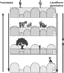
(3) CAD. LAB. XEOL. LAXE 35 (2010). ETCHED SURFACES, GRANITE LANDSCAPE, AND WATER STORAGE The most common landform assemblages of granitic terrains are inselberg landscapes comprising rocky outcrops in the shape of hills (domes, block-strewn, clusters of boulders, etc.) separated by pedimented and rolling plains. The details of the granite outcrops have been studied and explained by several authors over a long period (for reviews and examples, see CENTENO, 1987; PEDRAZA et al., 1989; THOMAS, 1994; VIDAL ROMANI and TWIDALE, 1998; TWIDALE, 2002; TWIDALE and VIDAL ROMANI, 2005; DOMINGUEZ VILLAR, 2007). It is widely accepted that the gross landforms and many minor features are of etch or two-stage origin, that is they were shaped by structure-controlled weathering in the shallow subsurface and exposed as a result of the stripping of the regolith. Differential weathering can take place many metres below the surface, and a fairly flat and smooth surface – transported material as well as the weathered mantle in situ – can hide an irregular weathering front. Thus erosion of the regolith may expose the erstwhile weathering front and effect the replacement of a smooth plain by an irregular and rough landscape, thus increasing the local geodiversity and biodiversity (figure 3). Significant landscape characteristics depend on the balance of alteration and transportation: a period of dominant weathering creates a weathering plain (as in phase 1 of figure 3); a period of dominant erosion creates a rocky and structural landscape (as in phase 4 of figure 3). Related to these variables, the proportion of outcrop to regolith in an area has a marked influence on the water balance.. Influence of granite landforms 101. At local scale, the permeability of fresh granite is virtually nil (10-11–10-2 cm/s), whereas FITTS (2002) records that in weathered granite values are in the range of 10-5–10-1 cm/s. Even at the regional level, the permeability in fresh granite is always much less than in weathered bedrock. For this reason, each regolith mass behaves as a free aquifer with the weathering front acting as an impermeable base. Traditional hydrogeological studies in granitic environments, within the field called “hard rock hydrogeology”, focus on the nature of fractures as it affects the circulation and storage of groundwater (see, for example, YÉLAMOS and VILLARROYA, 1997). However, in this work, the characteristics of the regolith and the storage of water as a free dendritic aquifer are more important than fractures or deep flow. In landscapes like those shown in Figures 3 and 4, infiltration into the granite outcrops is almost absent and, after rainfall, runoff. Fig. 3. The degree of exposition of the weathering front has a strong influence on the surface geometry and Geo and Biodiversity..
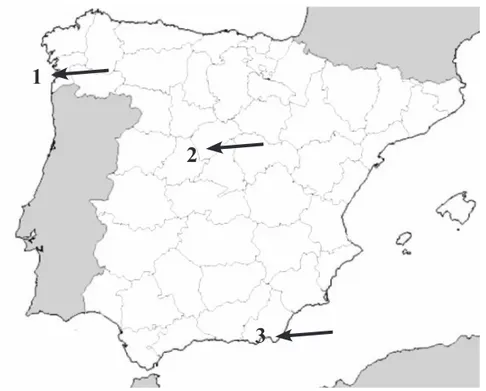
(4) 102 �������� Centeno et al.. CAD. LAB. XEOL. LAXE 35 (2010). into the adjacent regolith reaches high values with very short response times. Figure 4 represents a conceptual model of the hydrological cycle in these conditions. Obviously, this is a simplification, but it shows some interesting points. In a drainage basin, the total input of water into the patches of regolith (or in the aquifer) is directly related to the proportion of area occupied by the rock outcrops. Accordingly, most of the rainfall becomes runoff into the aquifer. Thus, the areas of regolith can receive several times the volume of water that would correspond to the local rainfall. Based on these ideas, Figure 5 shows the variables in the quantitative model of water balance developed in two previous works (CENTENO CARRILLO and GARCÍA. RODRÍGUEZ, 2008; GARCÍA et al., 2008), where further explanation can be found if required. APPLICATION OF THE MODEL TO DIFFERENT CLIMATIC SETTINGS. In order to apply the model to different climatic conditions, three meteorological stations in the Iberian Peninsula were selected, and use made of the average data of rainfall and potential evapotranspiration (ALMARZA, 1984). These climatic data were recorded at Boiro (Galicia), Villalba (Madrid), and Cabo de Gata (Andalucía) localities that are progressively drier from north to south (figure 6).. Rainfall Rock surface storage. Evapotranspiration Deep infiltration in fractures Local runoff. Rainfall. Runoff from outcrops. Rock surface evaporation. Infiltration in fractures. Infiltration and groundwater flow. Fig.4. Schematic water balance in granite landscapes (CENTENO CARRILLO and GARCÍA RODRÍGUEZ, 2008)..
(5) CAD. LAB. XEOL. LAXE 35 (2010). Total Surface S = S R + SO Total Precipitation P. Influence of granite landforms 103. Regolith or aquifer surface SR. Fresh granite or outcrop surface SO Rainfall on outcrop surface RfO=Rf*S O. Rainfall on regolith RfR = Rf*SR Water income in regolith W=Rf R+RuO. Runoff from fresh granite or rock RuO=Rf O-ETAO-IO. Infiltration to soil and aquifer IR=RfR+RuO -ETA R-RuR Runoff RuR. Evapotranspiration ETP or ETA. Infiltration into granite or rock IO (Assumed = 0). Storage into regolith StR. Fig. 5. Elements of the quantification model. S=surface, Rf=Rainfall, ETP or ETA=Evapotranspiration Potential or Actual, R=Runoff, I=Infiltration, St=Storage. Sub-index meaning: R=Regolith, O=Fresh Rock Outcrops.. 1 2. 3 Fig. 6. Location of the meteorological station used in the model: 1=Boiro; 2=Villalba; and 3=Cabo de Gata..
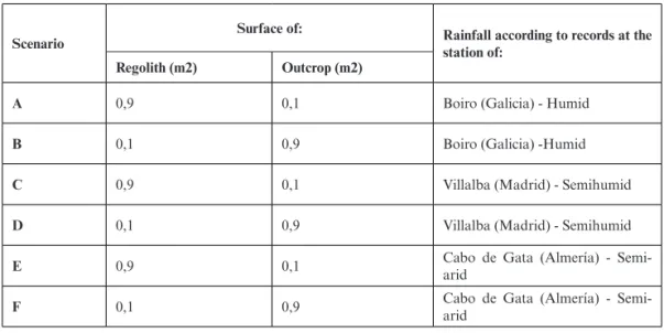
(6) 104 �������� Centeno et al.. CAD. LAB. XEOL. LAXE 35 (2010). With these data and the proportion of regolith/outcrop surface distribution, six scenarios were envisaged preparatory to applying the model (table 1). The surface proportion of regolith/outcrop has been modelled to two extreme values: 90% regolith to 10% outcrop, and 10% regolith to 90% outcrop. However, to facilitate the development of a spreadsheet, these relations are expressed as portions of one square metre – that means 0.9 m2 regolith to 0.1 m2 outcrop, and 0.1 m2 regolith to 0.9 m2 outcrop. Figure 7 shows a simplification of the two extreme. kinds of landscape and Table 1 shows the combination of these variables: with the resulting scenarios A—F. Other variables were maintained as constants in order to regularise the analysis of results. Regarding the thickness of regolith, a value of 2 m was assumed, which is a common value in the regolith of semi-exposed granite-etched surfaces. Regarding effective porosity in the regolith, a value of 0.02 was assumed, which also is a common value in weathered granite (FITTS, 2002).. Surface of:. Scenario. Rainfall according to records at the station of:. Regolith (m2). Outcrop (m2). A. 0,9. 0,1. Boiro (Galicia) - Humid. B. 0,1. 0,9. Boiro (Galicia) -Humid. C. 0,9. 0,1. Villalba (Madrid) - Semihumid. D. 0,1. 0,9. Villalba (Madrid) - Semihumid. E. 0,9. 0,1. Cabo de Gata (Almería) - Semiarid. F. 0,1. 0,9. Cabo de Gata (Almería) - Semiarid. Table 1. Scenarios A—F defined by surface regolith/outcrop ratio and annual average rainfall.. 10 %. Fresh rock. 90 %. 90 %. Regolith. Fig. 7. Schematic representation of the extreme surficial proportions outcrop/regolith used in the quantitative model.. 10 %.
(7) liters/square meter. CAD. LAB. XEOL. LAXE 35 (2010). Influence of granite landforms 105. 300. 300. 250. 250. 200. 200. 150. 150. 100. 100. 50. 50. 0. 0. liters/square meter. Oct Nov. Dic Ene Feb Mar Abr May Jun Jul Ago Sep. Oct Nov Dic Ene Feb Mar Abr May Jun Jul Ago Sep. 100. 100. 90. 90. 80. 80. 70. 70. 60. 60. 50. 50. 40. 40. 30. 30. 20. 20. 10. 10. 0. 0. liters/square meter. Oct Nov. Dic Ene Feb Mar Abr May Jun Jul Ago Sep. Oct Nov Dic Ene Feb Mar Abr May Jun Jul Ago Sep. 30. 30. 25. 25. 20. 20. 15. 15. 10. 10. 5. 5. 0. 0 Oct Nov Dic Ene Feb Mar Abr May Jun Jul Ago Sep. Rainfall Storage in regolith. Oct. Nov Dic Ene Feb Mar Abr May Jun Jul Ago Sep. ETA in regolith Runoff. Fig. 8. Water balance for the climatic and geomorphic scenarios A—F..
(8) 106 �������� Centeno et al.. The model also allows for the outcrop retention rate (Tra) and the regolith deep-infiltration rate (Tir) to be understood. Their values may vary depending on the morphology of the outcrops and the presence and geometry of fractures. In all scenarios, we have assigned values for small outcrops, domes or boulders, with few pseudokarstic forms and fractures. Such relief is common in semi-exposed etch surfaces, where the water use and management is very important for farming purposes. Figure 8 shows the water balances of the six scenarios of Table 1. In these figures are represented the monthly values of the main variables: local rainfall, ETA in regolith, storage in regolith and runoff. Water balance of scenario A Scenario A (figure 8A) has a ratio regolith/outcrop=0.9/0.1 and rainfall under humid climatic conditions, as recorded at the Boiro meteorological station. As expected for a humid environment, the regolith remains saturated most of the year (September to May) and runoff essentially reflects rainfall with small differences due to ETA consumption of water. Only July and August show an evapo-transpiration deficit (ETA<ETP). Water balance of scenario B Scenario B (figure 8B) has a ratio regolith/outcrop=0.1/0.9 and rainfall according to Boiro meteorological station (Humid). An increase of the area of outcrop increases the correspondence between rainfall and runoff and keeps the regolith saturated from September to June. In addition, ETA in regolith equals ETP all the year long – but. CAD. LAB. XEOL. LAXE 35 (2010). it is important to note that, with 10% surface covered with regolith, the ETP in regolith is only one tenth of the local or general ETP. Water balance of scenarios C and D Scenario C (figure 8C) has a ratio regolith/outcrop=0.9/0.1 and rainfall in semi-humid climatic conditions according to Villalba meteorological station. Scenario D (figure 8D) has a ratio regolith/ outcrop=0.1/0.9 and rainfall according to Villalba meteorological station (Semihumid). Scenarios C and D are essentially equal to A and B. However, the increase of outcrop area corresponds to a reduction of the number of months without runoff or storage saturation – and this effect is more pronounced in the semi-humid environment. Water balance of scenario E Scenario E (figure 8E) has a ratio regolith/outcrop=0.9/0.1 and rainfall under semi-arid climatic conditions, as recorded at the Cabo de Gata meteorological station. ETA is always equal to or greater than rainfall through the year and, consequently, there is no runoff at any time (when measured on a monthly basis). The small excess ETA over rainfall always depends on the storage of the previous month. The small oscillation in storage values and the monthly delay between storage and excess ETA are only a methodological artefact. It would disappear if daily balances were considered..
(9) CAD. LAB. XEOL. LAXE 35 (2010). Water balance of scenario F Scenario F (Figure 8F) has a ratio regolith/outcrop=0.1/0.9 and rainfall according to Cabo de Gata meteorological station (Semi-arid). An increase in the proportion of outcrops always produces an increase in the availability of stored water or runoff. Not even the variability of rainfall masks this fact. Indeed, the regolith is saturated form October to May and, in addition, there is runoff every month. Thus the differences between scenarios E and F are extremely interesting. One result is that in the regolith, ETA equals ETP every month from October to May, which affects the possibilities and characteristics of any vegetation cover. In this sense, there is a striking similarity between scenarios A and F. On the other hand, with saturated soils and permanent runoff, these etched surfaces are highly exposed to flash floods as a result of any storm. For example, DANIN (1983) cites frequent flooding in the area of Mount Sinai in Egypt. CONCLUSION The redistribution of water between outcrops and regolith modifies significantly the values of underground water storage and time distribution of runoff. Accordingly, the landform has a decisive influence on the potential for water resource management, especially in places with water scarcity. The similar qualitative results, shown in Figures 8A and 8F, result from humid climatic conditions combined with scarce outcrops (10% surface), on the one hand, and semi-arid climate with abundant outcrops (90%), on the other. The balance in the proposed semi-arid. Influence of granite landforms 107. scenarios shows that in large areas of the regolith ETP always exceeds the infiltration by rainfall, making it impossible to recharge and store water in the aquifer and soil. On the contrary, when outcrops are dominant, regolith units receive runoff from the outcrops in addition to the direct rainfall. Then, the incomes to regolith can overcome the ETP in the regolith, and consequently there is an increase in reserves and even excess water. As water is a limiting factor for ecosystems in arid regions, the ratio of outcrop to regolith could be a determining factor in water balance, biodiversity, and human use. As explained in the introduction to this paper, there are good examples of the traditional use of these conditions in the management of water resources in arid and semi-arid climates. Relations between Geomorphology, Hydrogeology, and Biodiversity in granitic regions are poorly explored and this study shows that there are connections that can yield interesting results. In addition, we must add that these processes, leading to a very diverse topography, allow more biodiversity than other more homogeneous regions. In order to understand these connections, the relation between detailed geomorphology or geometry of granite landforms (domes, boulders, fractures, rock-basins, tafoni, etc.), and the water-flow or water-storage on outcrops ought to be studied. The standing time of water on different kinds of outcrops, and the rates of evaporation on outcrops are some of the values to measure, if a better model of this system is to be achieved. In summary, outcrops standing relatively high in the local relief carry the same implications for water availability as an increase in rainfall affecting the better soil regolithic areas. It also carries significant implications for geomorphological modelling, for the transfer.
(10) 108 �������� Centeno et al.. of water from rocky hill to regolithic plain has led to the preferential weathering and erosion of the latter and a consequent increase in relief amplitude through time (TWIDALE and BOURNE 1975; TWIDALE, 2007). REFERENCES ALMARZA, C. (1984). Fichas hнdricas normalizadas y otros parбmetros hidrometeorolуgicos. Instituto Nacional de Meteorología, Madrid. CENTENO, J. D. (1987). Morfologнa granнtica de un sector del Guadarrama Occidental. Editorial Complutense, Colección Tesis Doctorales nº262/88, Madrid. CENTENO CARRILLO, J. D., and GARCÍA RODRÍGUEZ, M. (2008). Balance hídrico de las superficies grabadas en rocas graníticas. Un modelo geomorfológico e hidrogeológico con implicaciones ambientales. Tecnologнa y Desarrollo, 6. In press. DANIN, A. (1983). Desert Vegetation of Israel and Sinai. Cana Publishing House, Jerusalem, Israel. DOMÍNGUEZ VILLAR, D. (2007). Anбlisis morfomйtrico de pilancones: consideraciones, genйticas, evolutivas y paleoambientales. Tesis Doctoral, Servicio de Publiciaciones de la Universidad Complutense de Madrid, Madrid. FITTS, C. R. (2002). Groundwater Science. Academic Press, London. GARCÍA RODRÍGUEZ, M., CENTENO, J. D. and DE PABLO, M. A. (2008). Relieve y agua en regiones graníticas: un modelo cuantitativo con aplicaciones en la gestión del agua y la geodiversidad. M+A Revista Electrуnica de Medioambiente, Universidad Complutense de Madrid, 5: 26-40. ISSAR, A. (1990). Water Shall Flow from the Rock. Hydrogeology and Climate in the Lands of the Bible. Springer-Verlag, New York.. CAD. LAB. XEOL. LAXE 35 (2010). MOUSTAFA, A. A. and KLOPATEK, J. M. (1995). Vegetation and landforms of the Saint Catherine area, southern Sinai, Egypt. Journal of Arid Environments, 30: 385–395. PEDRAZA, J., SANZ, M. A. and MARTÍN, A. (1989). Formas granнticas de la Pedriza. Agencia de Medio Ambiente, Comunidad de Madrid. THOMAS, M. F. (1994). Geomorphology in the Tropics. John Wiley & Sons, Chichester, UK. TWIDALE, C. R. (2002). The two-stage concept of landform and landscape development involving etching: origin, development and implications of an idea. Earth-Science Reviews, 57 (1-2): 37-74. TWIDALE, C. R., (2007). Concatenation and resultant inequalities in denudation. Physical Geography, 28: 50-75. TWIDALE, C. R. and BOURNE, J. A. (1975). Episodic exposure of inselbergs. Geological Society of America Bulletin, 86: 1473-1481. TWIDALE, C. R. and SMITH, D. L. (1971). A ‘perfect desert’ transformed: the agricultural development of north-western Eyre Peninsula, South Australia. The Australian Geographer, 11 (5): 437-454. TWIDALE, C. R. and VIDAL ROMANI, J. R. (2005). Landforms and Geology of Granite Terrains. Balkema, Leiden. VIDAL ROMANI, J. R. and TWIDALE, C. R. (1998). Formas y paisajes graníticos. Universidade da Coruña, Servicio de Publicacións, A Coruña. YÉLAMOS, J. G. and VILLARROYA, F. (Editors) (1997) Hydrogeology of Hard Rocks. International Association of Hydrogeologists, Spanish Chapter (AIHGE), Iberian Subgroup on Hard Rock Hydrogeology, Madrid..
(11)
Figure

+2

Documento similar