Article
Towards an Autonomous Industry 4.0 Warehouse:
A UAV and Blockchain-Based System for Inventory
and Traceability Applications in Big Data-Driven
Supply Chain Management
†
Tiago M. Fernández-Caramés * , Oscar Blanco-Novoa , Iván Froiz-Míguez and Paula Fraga-Lamas *
Department of Computer Engineering, Faculty of Computer Science, Universidade da Coruña, 15071 A Coruña, Spain; [email protected] (O.B.-N.); [email protected] (I.F.-M.)
* Correspondence: [email protected] (T.M.F.-C.); [email protected] (P.F.-L.); Tel.: +34-981-167-000 (ext. 6051) (P.F.-L.)
† This paper is an extended version of our conference paper: Fernández-Caramés, T.M.; Blanco-Novoa, Ó.; Suárez-Albela, M.; Fraga-Lamas, P. A UAV and Blockchain-based System for Industry 4.0 Inventory and Traceability Applications. In Proceedings of the 5th International Electronic Conference on Sensors and Applications, 15–30 November 2018; Available online:https://ecsa-5.sciforum.net/.
Received: 31 March 2019; Accepted: 22 May 2019; Published: 25 May 2019
Abstract: Industry 4.0 has paved the way for a world where smart factories will automate and upgrade many processes through the use of some of the latest emerging technologies. One of such technologies is Unmanned Aerial Vehicles (UAVs), which have evolved a great deal in the last years in terms of technology (e.g., control units, sensors, UAV frames) and have significantly reduced their cost. UAVs can help industry in automatable and tedious tasks, like the ones performed on a regular basis for determining the inventory and for preserving item traceability. In such tasks, especially when it comes from untrusted third parties, it is essential to determine whether the collected information is valid or true. Likewise, ensuring data trustworthiness is a key issue in order to leverage Big Data analytics to supply chain efficiency and effectiveness. In such a case, blockchain, another Industry 4.0 technology that has become very popular in other fields like finance, has the potential to provide a higher level of transparency, security, trust and efficiency in the supply chain and enable the use of smart contracts. Thus, in this paper, we present the design and evaluation of a UAV-based system aimed at automating inventory tasks and keeping the traceability of industrial items attached to Radio-Frequency IDentification (RFID) tags. To confront current shortcomings, such a system is developed under a versatile, modular and scalable architecture aimed to reinforce cyber security and decentralization while fostering external audits and big data analytics. Therefore, the system uses a blockchain and a distributed ledger to store certain inventory data collected by UAVs, validate them, ensure their trustworthiness and make them available to the interested parties. In order to show the performance of the proposed system, different tests were performed in a real industrial warehouse, concluding that the system is able to obtain the inventory data really fast in comparison to traditional manual tasks, while being also able to estimate the position of the items when hovering over them thanks to their tag’s signal strength. In addition, the performance of the proposed blockchain-based architecture was evaluated in different scenarios.
Keywords: UAV; drones; Industry 4.0; traceability; blockchain; inventory; supply chain management; logistics; RFID; smart contracts; DLT; IPFS
1. Introduction
The concept Industry 4.0 fosters the evolution of traditional factories towards smart factories through the use of some of the latest advances in paradigms and technological enablers like big data [1], augmented reality [2–5], robotics [6], cyber–physical systems [7], fog computing [8,9] or the Industrial Internet-of-Things (IIoT) [10]. For instance, the application of advanced Big Data analytics in supply chain management can help to improve decision making for all activities across the supply chain. In particular, in inventory tasks [11], big data can help organizations to design modern inventory optimization systems, predict inventory needs, respond to changing customer demands, reduce inventory costs, obtain a holistic view of inventory levels, optimize the flow and storage of inventory, or even reduce safety stock.
Unmanned Aerial Vehicles (UAVs) are also considered a key technology for smart factories, since they allow carrying out repetitive and dangerous tasks without almost any human intervention or supervision. In the last years, UAVs proved to be really useful in fields like remote sensing (e.g., mining), real-time monitoring, disaster management, border and crowd surveillance, military applications, delivery of goods, precision agriculture, infrastructure inspection or media and entertainment, among others [12,13]. In many of such fields, UAVs perform tasks that constitute one of the foundations of Industry 4.0: to collect as much data as possible from multiple locations dynamically. In addition, UAVs not only collect data, but are also able to store, process and exchange information with suppliers or with devices deployed in factories.
Industry 4.0 technologies have to be integrated horizontally so that manufacturers and suppliers can cooperate. In order for a company to dynamically determine its need for supplies, it is necessary to keep track of their stock. For such a purpose, many companies carry out a periodic inventory and decide whether more supplies have to be purchased. Unfortunately, in many companies, such an inventory is performed manually, making it a really costly, time-consuming and tedious task. There exists software to automate stock control, but when it is operated by humans, the process is prone to accounting errors and it is usually not carried out in real time. Therefore, the ideal inventory should be performed automatically, in real-time and in an efficient, flexible and safe way.
UAVs have been applied to inventory and traceability tasks in the past. For instance, some of the latest commercial UAV-based systems [14–16] make use of a scanner installed on a UAV that performs a predefined flight in order to read barcodes. In the literature, there are more ambitious solutions like the one presented in [17], which describes an autonomous UAV that makes use of Radio-Frequency IDentification (RFID) and self-positioning/mapping techniques based on a 3D Light Detection and Ranging (LIDAR) device.
Blockchain and other Distributed Ledger Technologies (DLTs) are also predicted to be essential for many industries [18,19], since they allow for storing the collected data (or a proof of such data) so that they can be exchanged in a secure way among entities that do not trust each other. Although blockchain can be considered to be still under development in many aspects [20,21], some of its applications for fields where trust is a required (e.g., finance) have been already deployed [22]. Moreover, blockchain and other DLT enable the creation of smart contracts, which can be defined as self-sufficient decentralized codes that are executed autonomously when certain conditions of a business process are met. Thus, the code of a smart contract translates into legal terms the control over physical or digital objects through an executable program. For instance, a smart contract may be used as a sort of communication mechanism with a supplier when certain materials run low and one expects more incoming work that would require them.
Specifically, this article includes the following contributions:
• Besides recent literature on blockchain-based autonomous business activity for UAVs [23], to our knowledge, this article is the first that proposes the theoretical design and practical implementation of a UAV-based, versatile, modular and scalable architecture aimed at fostering cyber security (specially, data integrity and redundancy) by including together the use of blockchain and a decentralized database solution. Specifically, the proposed system can use a blockchain to receive the inventory data collected by UAVs, validate them, ensure their trustworthiness and make them available to the interested parties. Moreover, the system is able to use smart contracts to automate certain processes without human intervention.
• We also evaluated the performance of the proposed decentralized database and the implemented
smart contracts in diverse scenarios.
The rest of this paper is structured as follows. Section2reviews the previous work related to the use of UAVs in industrial applications, as well as the state-of-the-art of technologies for industrial inventory and traceability. Section3details the architecture of the proposed system, while Section4describes its implementation. Finally, Section5is devoted to the experiments and Section6to the conclusions.
2. Related Work
The solution proposed and evaluated in this article requires four essential elements to keep product traceability and obtain the inventory of a warehouse:
• A labelling technology: items need to be attached to tags or labels that are associated with a unique identifier and, in some cases, with additional information on the item.
• An identification technology: the labels or tags attached to the items have to be read remotely to automate the inventory processes.
• A UAV: although most labelling technologies make use of handheld readers, this article proposes the use of a UAV to automate and to accelerate data gathering.
• Supply management techniques: data gathering, processing and storing processes need to be efficient when handling a relevant number of information.
The most relevant aspects of these four elements are first studied and then analyzed in the following sub-sections in order to later determine the main components of the designed system.
2.1. Labelling and Identification Technologies
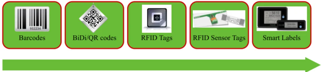
Currently, one of the most popular identification technologies is barcodes, which are essentially a visual representation of Global Trade Item Number (GTIN) codes [24]. However, barcode readers need Line-of-Sight (LoS) with the barcode label to read it correctly and it can only be read at relatively short distances (just a few tens of centimeters). Despite the mentioned limitations, barcodes improved inventory speed in industrial scenarios with respect to traditional manual identification procedures. In addition, barcode label manufacturing cost is really low, since they only require specific software and a printer.
In the middle of the 1990s, barcodes evolved towards bidimensional codes known as BiDimensional (BiDi) or Quick Response (QR) codes, which are able to store data (usually more than 1800 characters) and can be read with a simple smartphone camera, thus, reducing the overall cost of the inventory/traceability system. Nonetheless, QR codes can only be read up to a distance that depends on the size of the QR marker (the reading distance is often estimated to be less than ten times of the QR code diagonal).
evolution [25]. Such a kind of label can be read at a distance that goes from several centimeters to several tens of meters [26]. In fact, reading distance is commonly related to the type of RFID tag: passive tags (i.e., tags that do not depend on batteries for carrying out RFID communications) reading distance usually does not exceed 20 m, while active tag communications (i.e., the ones that do use batteries for carrying out RFID communications) can easily reach 100 m in unobstructed environments. In addition, certain RFID tags can store information, which may be useful in certain inventory and traceability processes. It must be also noted that, in the last years, academia and industry have evolved RFID tags in order to add to them sensing capabilities, thus, creating tags that are able to measure temperature [27], acceleration [28] or light [29].
Figure 1.Technological evolution of identification tags.
The next step in the tag evolution are the so-called smart labels [30], which are noticeably more complex than RFID tags and allow for providing industry 4.0 functionality like event detection [31], operator interactivity, a display for visual feedback, one or more communication technologies, positioning services or embed IoT sensors that collect environmental data that are relevant for the state of a
product. Omni-ID’s View smart labels [32] are one of the few on the market and embed an e-ink
display, flash memory storage, active and passive UHF RFID transceivers, and an infrared receiver for beacon-based positioning.
Besides the identification technologies related to the previously mentioned labelling solutions, there are others that have been suggested. For instance, Near Field Communication (NFC) [33] has been used in inventory applications, but it is only dedicated to scenarios where a short reading distance (often less than 30 cm) is needed.
There are other technologies, which, have been actually conceived as communications technologies, but can also provide identification mechanisms. For instance, Bluetooth Low Energy (BLE) is a generic Wireless Personal Area Network (WPAN) technology that usually does not reach more than 10 m when used through smartphones or up to 100 m in industrial applications [34]. There are diverse BLE profiles and specific devices called beacons that can be useful in certain inventory and traceability applications, as well as in indoor locations [35,36] and IoT applications [37,38], since they transmit a periodic signal to be located and identified.
The Media Access Control (MAC) address of a WiFi device (i.e., a device compatible with the IEEE 802.11 family of standards, including its vehicular version [39,40]) can also be used for identification purposes, as well as other technologies less frequently used in inventory tags, like devices based on ultrasounds, infrared communications, ZigBee [41], Low-Power Wide-Area Network (LoRA) [42], Dash7 [43], Ultra Wide Band (UWB), WirelessHART [44], RuBee (IEEE standard 1902.1), SigFox [45], ANT+ [46] or IEEE 802.11ah, among others.
Table 1.Main characteristics of the most relevant communications and identification technologies for inventory and traceability applications.
Technology FrequencyBand
Max. Range in Optimal Conditions
Data Rate Power type Main Features Main Limitations for InventoryApplications Popular Applications
ANT+ 2.4 GHz 30 m 20 kbit/s Ultra-low power Up to 65,533 nodes Lack of commercial inventory tags Health, sport monitoring
Barcode/QR − <4 m − No power Very low cost, visual decoding Need for LOS Asset tracking and marketing
Bluetooth 5 LE 2.4 GHz <400 m 1360 kbit/s Low power Batteries only last days to weeks Batteries need to be recharged, shared
communications radio frequency Beacons, wireless headsets
DASH7/ISO 18000-7 315–915 MHz <10 km 27.8 kbit/s Very low power, alkaline batterieslast months to years Long reading distance, multi-yearbattery Batteries need to be recharged, sharedcommunications radio frequency Smart industry and military
HF RFID 3–30 MHz
(13.56 MHz) a few meters <640 kbit/s No power NLOS, no need for batteries Relatively short reading range
Smart Industry, payments, asset tracking
Infrared (IrDA) 300 GHz to
430 THz a few meters 2.4 kbit/s–1 Gbit/s Low power
Low-cost hardware, security, high speed
Need for LOS, batteries may drain fast
when transmitting continuously Remote control, data transfer
IQRF
433 MHz, 868 MHz or 916 MHz
hundreds of
meters 19.2 kbit/s Low power Long communications range Shared communications radio frequency
Internet of Things and M2M applications
LF RFID 30–300 KHz
(125 KHz) <10 cm <640 kbit/s No power NLOS, low cost
Very short reading distance (in general, a few centimeters)
Smart Industry and security access
NB-IoT LTE in-band,
guard-band <35 km <250 kbit/s Low power Long reading range Dependent on third-party infrastructure IoT applications
NFC 13.56 MHz <20 cm 424 kbit/s No power Low cost Short reading distance Ticketing and payments
RuBee 131 KHz 20 m 8 kbit/s Very low power Magnetic propagation, multi-year
battery life Only one known manufacturer
Applications with harsh electromagnetic propagation
LoRa/LoRaWAN 2.4 GHz kilometers 0.25–50 kbit/s Low power Long range, long battery life Very few commercial inventory tags, more
expensive than other alternatives Smart cities, M2M applications
SigFox 868–902 MHz 50 km 100 kbit/s Low power Long range, global cellular network Dependent on third-party infrastructure Internet of Things and M2Mapplications
UHF RFID 30 MHz–3 GHz tens of meters <640 kbit/s Very low power or no power NLOS, wide range of suppliers, lowcost
Propagation problems with metal and liquids (specially with high transmission frequencies)
Smart Industry, asset tracking and toll payment
Ultrasounds (2–10 MHz)>20 kHz <10 m 250 kbit/s Low power Based on sound wave propagation Relatively short reading range Asset positioning and location
UWB/IEEE 802.15.3a 3.1 to
10.6 GHz < 10 m >110 Mbit/s
Low power (batteries last hours to days)
802.11b/g/n/ac) 2.4–5 GHz <150 m
up to 433 Mbit/s (one stream)
High power (batteries may last
hours) High speed, ubiquity Short battery life Internet access, broadband
Wi-Fi HaLow/IEEE
802.11ah 868-915 MHz <1 km
>100 Kbit/s per
channel Low power Long communications range
Not compatible with previous Wi-Fi standards, shared communications radio frequency
IoT applications
WirelessHART 2.4 GHz <10 m 250 kbit/s Low power (Batteries last several years)
Compatibility with HART protocol, standardized as IEC 62591
Shared communications radio frequency, lack of commercial inventory tags
Wireless sensor network applications
ZigBee 868–915 MHz,
2.4 GHz <100 m 20–250 kbit/s
Very low power (batteries last
months to years) Easy to scale, up to 65,536 nodes
Relatively expensive hardware, potential interference from devices in the same frequency band
2.2. UAVs for Inventory and Traceability Applications
UAVs have been suggested for providing services in a number of industrial applications, like for critical infrastructure inspections [47–51] or sensor monitoring [52–54]. It is important to note that industrial environments require certain UAV features that may differ from other applications, like obstacle collision avoidance [55], automatic cargo transport [56,57] or logistics optimization for swarms of UAVs [58].
UAVs have already been used for traceability and inventory management applications. For example, in [59], the authors use a QR code-based UAV to detect items. Although the system shows an impressive precision of 98.08%, it requires LoS with QR codes, which in practice limits its application to certain scenarios. Another interesting article is [60], where UWB devices are used to accurately position (i.e., with an indoor location accuracy of only 5 cm) a UAV that performs inventory management tasks.
RFID is the identification technology embedded in a UAV in [61]. In such a paper, the scenario is an open storage yard that is monitored by a DJI Phantom 2 drone that carries a passive UHF reader embedded by a PDA. Researchers from MIT have also conceived a similar theoretical system where multiple UAVs carry RFID readers to aid inventory automation in a warehouse [62]. Finally, it is worth mentioning the work in [63], which proposes the collaboration of an Unmanned Ground Vehicle (UGV) and a UAV to perform inventory tasks in a warehouse. Specifically, the UGV is used as a ground reference for the indoor flight of the UAV, which embeds a camera that recognizes augmented reality markers. Thus, the UGV carries the UAV to places where there are items to be inventoried and then the UAV flies vertically to scan them, sending the collected data to a ground station.
2.3. Big Data for Inventory and Supply Chain Management
Big Data analytics can also be applied to optimize knowledge extraction and decision-making in inventory and supply management applications. A comprehensive review on the application of big data to such fields can be found in [64], with the management of safety stocks being one of the key aspects [65]. Moreover, other authors have already analyzed how to face the current challenges and opportunities that the transformation of supply chain management suppose in order to be driven by big data techniques [66].
With respect to practical deployments, in [67], the authors propose a big data analytics framework that processes the information collected from an RFID-enabled shop floor. The authors define, at a logistics management level, different Key Performance Indicators (KPIs) in order to evaluate different manufacturing objects and the main findings are converted into managerial guidance for decision making.
Regarding the use of big data analytics for inventory applications, several advantages can be pointed out [11]: it can help to take informed decisions related to inventory performance, it may aid to obtain a holistic view at inventory levels across the supply chain and with external stakeholders, and it enables to predict inventory needs and changes in customer demand using statistical forecasting techniques, as well as to reduce inventory costs dramatically.
2.4. Analysis of the State of The Art
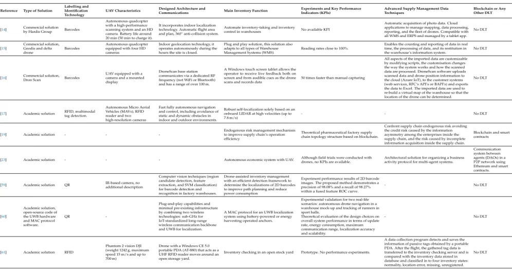
Table 2.Comparison of the main features of the most relevant UAV-based inventory systems and the proposed system.
Reference Type of Solution
Labelling and Identification Technology
UAV Characteristics Designed Architecture andCommunications Main Inventory Function Experiments and Key PerformanceIndicators (KPIs) Advanced Supply Management DataTechniques Blockchain or AnyOther DLT
[14] Commercial solutionby Hardis Group Barcodes
Autonomous quadcopter with a high-performance scanning system and an HD camera. Battery life around 20 min (50 min to charge it).
It incorporates indoor localization technology. Automatic flight area and plan, 360◦anti-collision system.
Automate inventory-taking and inventory
control in warehouses No available KPI
Automatic acquisition of photo data. Cloud applications to manage mapping, data processing, reporting, and the fleet of drones. Compatible with all WMS and ERPS and managed by a tablet app.
No DLT hours the site is closed.
Plug and play solution, this solution also adapts to all types of Warehouse Management Systems (WMS)
Reading rates close to 100%.
Enables the counting and reporting of data in real time, the processing of data, and its restitution in the warehouse’s information system.
No DLT
[16] Commercial solution,Dron Scan Barcodes
UAV equipped with a camera and a mounted display
DroneScan base station communicates via a dedicated RF frequency (not WiFi or Bluetooth) and has a range of over 100 m.
A Windows touch screen tablet allows the operator to receive live feedback both on screen and from audible cues as the drone scans and records data
50 times faster than manual capturing
All aspects of the imported data are customizable by modifying scripts, the customisation changes the way the system works and how the scanned data are processed. DroneScan software uploads scanned data and drone position information to the cloud (Azure IoT), to the customer systems (web services, RFC’s API’s or BAPI’s) and exports the data to Excel. The imported data are used to re-build a virtual map of the warehouse so that the location of the drone can be determined.
No DLT
[17] Academic solution RFID, multimodaltag detection.
Autonomous Micro Aerial Vehicles (MAVs), RFID reader and two high-resolution cameras
Fast fully autonomous navigation and control, including avoidance of static and dynamic obstacles in indoor and outdoor environments.
Robust self-localization solely based on an onboard LIDAR at high velocities (up to 7.8 m/s)
- - No DLT
[19] Academic solution - -
-Endogenous risk management mechanism to improve supply chain’s operation efficiency
Theoretical pharmaceutical factory supply chain topology structure based on blockchain.
Confront supply chain endogenous risk avoiding the credit risk caused by the information asymmetry among the enterprises inside the supply chain, and the risk caused by incomplete information acquisition inside the supply chain.
Blockchain and smart contracts
[23] Academic solution - - - Autonomous economic system with UAV. Although field trials were conducted withdrones, no KPIs are available. Architectural solution for organizing a businessactivity protocol for multi-agent systems.
Communication
[59] Academic solution QR IR-based camera, noadditional description
Computer vision techniques (region with an efficient detection framework to determine the localizations of 2D barcodes to improve path planning and reduce power consumption
Experiment performance results of 2D barcode images. The proposed method demonstrates a precision of 98.08% and a recall of 98.27% within a fused feature ROC curve.
- No DLT
A MAC protocol for an UWB localization system using battery-powered or energy harvesting operated anchors.
Experimental validation for two real-life scenarios: autonomous drone navigation in a warehouse mock-up and tracking of runners in sport halls.
Theoretical evaluation of the design choices on overall system performance in terms of update rate, energy consumption, maximum communication range, localization accuracy and scalability.
- No DLT
[61] Academic solution RFID
Phantom 2 vision DJI (weight 1242 g, maximum speed 15 m/s and up to 700 m)
Drone with a Windows CE 5.0 portable PDA (AT-880) that acts as a UHF RFID reader moves around an open storage yard.
Inventory checking in an open stock yard Prototype. No performance experiments.
A data collection program detects and saves the information of passive tags obtained by a portable PDA. After the flight, the gathered tag data is transferred to the inventory checking server and is compared with the inventory data stored in database and classified in to four inventory states: normality, location error, missing, unregistered.
Table 2.Cont.
Reference Type of Solution
Labelling and Identification Technology
UAV Characteristics Designed Architecture andCommunications Main Inventory Function Experiments and Key PerformanceIndicators (KPIs) Advanced Supply Management DataTechniques Blockchain or AnyOther DLT
[62] Academic solution RFID (EPC)
Draganfly commercial radio-controlled helicopters 82×82 cm, average flight time of 12 min
RFID readers attached to the simulated UAVs are assumed to have a 100% read-guarantee when EPC tags are within the reading range of the RFID reader.
Read the EPCs in the warehouse within the 12-min duration
Preliminary simulation results, three-dimensional graphical simulator framework has been designed using Microsoft XNA framework to represent a real warehouse
Coordinated distribution of the UAVs. Although six independent UAVs were deployed, they collectively failed to complete the task of finding all EPCs
No DLT
[63] Academic solution Barcodes, AR markers
UAVs and UGVs with LIDARs
UAV and UGV work cooperatively using vision techniques. The UGV acts as a carrying platform and as an AR ground reference for the indoor flight of the UAV. While the UAV is used as the mobile scanner.
Novel indoor warehouse inventory scheme to improve automation as well as the diminution of time consumption and injuries risks.
Experimental setup is to validate the visual guidance of the UAV taking the UGV as a ground. UAV need to be equipped with sensors to avoid collision with the racks during the scanning process.
- No DLT
[67] Academic solution RFID - - Physical Internet-based intelligentmanufacturing shop floors Experiments on logistics rules for optimizingthe delivery time
Big data analytics framework that processes the information collected from an RFID-enabled shop floor
No DLT
Proposed
system Academic solution RFID
Indoor/outdoor hexacopter designed from scratch as a trade-off between cost, modularity, payload capacity and robustness.
Modular and scalable UAV-architecture using WiFi infrastructure and ability to run decentralized applications.
Enable inventory and traceability applications focused on a holistic view at inventory levels across the supply chain and with external stakeholders
Prototype and performance experiments: inventory time in the warehouse under different circumstances, signal strength monitoring and performance of the implemented architecture (decentralized database and blockchain response latency)
First of all, few papers detail practical UAV-based applications for inventory and traceability applications, specially with RFID as the identification technology embedded in the UAV. Specifically, most of them do not take into consideration in the UAV design a trade-off between cost, modularity, payload capacity and robustness. Second, the emergence of Big Data analytics impose additional issues to emerging solutions that are still open for research like:
• Data volume. The amount of heterogeneous data generated by Industry 4.0 technologies has increased exponentially, especially the information collected from Industrial Internet of Things (IIoT) devices and remote entities. These data have to be hosted, distributed and computed across a number of organizations ensuring a certain degree of operational efficiency.
• Speed. Decisions should be made as quickly as possible (ideally, in real time), so there is a need for speeding up the processes related to them: data production, data collection, reliability, data transfer speed, data storage efficiency, knowledge extraction and analysis, as well as decision-making.
• Verification and veracity. There is a myriad of factors that may derive into collecting bad data (e.g., noise, inaccurate readings), so they should be verified so that only valid or true data are further processed.
• Versioning. Massive datasets should be linked and the accidental disappearance of important data should be prevented.
• Accessibility. Stakeholders must be able to access data through resilient networks, which enable persistent availability with or without Internet connectivity.
Although different alternatives have been proposed for facing some of the issues mentioned above, DLTs seem to be the most promising solution in order to guarantee operational efficiency and data transparency, authenticity and security. However, there is a shortcoming related to the fact that, although there are examples in the literature of DLTs applied to other sectors, to the knowledge of the authors, there are no examples of DLTs or blockchain-based architectures for the upcoming big data-driven supply chain applications.
Finally, it must be noted that the use of current DLTs, and specifically blockchain, involve certain weaknesses related to the immature status of the technology, like the lack of scalability, high energy consumption, low performance, interoperability risks or privacy issues [18–22]. Moreover, blockchain technologies face design limitations in transaction capacity (i.e., throughput and latency), in validation protocols or in the implementation of smart contracts. Therefore, architecture design should consider these constraints together with the specific decentralization requirements. Furthermore, as of writing, there are several open issues that require more research. For instance, no references were found in the literature on the evaluation of the performance of blockchain-based application architectures.
As a consequence of the previous analysis, the design of the system proposed in this article has been devised taking the previous shortcomings into consideration.
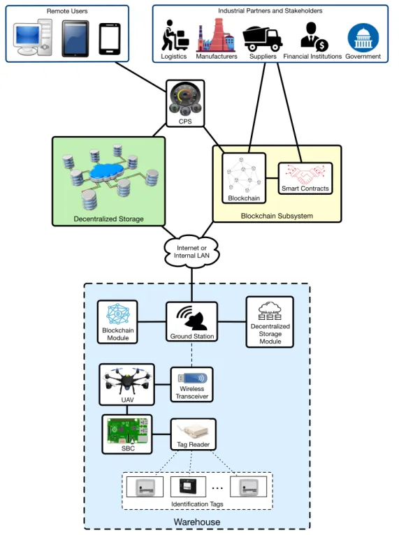
3. Design of the System
Warehouse Blockchain
Module
Tag Reader Wireless Transceiver UAV
Ground Station CPS
Internet or Internal LAN
Blockchain Subsystem
Blockchain
Smart Contracts
SBC
Identification Tags
…
Decentralized Storage Module
Decentralized Storage
Remote Users Industrial Partners and Stakeholders
Logistics Manufacturers Suppliers Financial Institutions Government
Figure 2.Proposed communications architecture.
interested in carrying out audits or financial evaluations, or may need to verify the fulfillment of certain laws [21]:
• Transparency. Blockchain and smart contracts allow for providing access to inventory and traceability information to third-parties, which can monitor it and determine whether it has been tampered with.
• Application decentralization. Medium and large software deployments usually require to make use of centralized servers that are often expensive to deploy and maintain [69,70]. Blockchain is one of the technologies that enable application decentralization and, at the same time, avoids the involvement of middlemen that provide outsourced centralized solutions.
• Data authenticity. In many industries, it is essential to trust the inventory and traceability data received from suppliers, manufacturers or governments. Blockchain enables to implement mechanisms that provide accountability and, as a consequence, trustworthiness. In addition, it is worth noting that such data trustworthiness is essential for the effectiveness of the application of Big Data techniques.
• Data security. Blockchain allows for preserving the privacy and anonymity of the data exchanged with other entities, so that they remain private to non-authorized parties.
• Operational efficiency. Blockchain technologies are able to automate the verification of the attributes of a transaction in an inexpensive way.
With respect to the decentralized storage, it is included in the architecture in order to provide the following three main advantages that useful for enhancing the security of the inventory and traceability data:
• Redundancy. Decentralized storage systems, when properly synchronized, are able to create copies of the stored data automatically in multiple nodes, so the information is not available from a single source that may constitute a point of failure.
• Tolerance to cyber-attacks. Since the information can be available from multiple data storage nodes, if one or several of them are taken down by cyber-attacks (e.g., Denial of Service (DoS) or Distributed Denial of Service (DDoS) attacks), it may be possible to access it through the other nodes.
• Ability to run decentralized applications (dApps). Besides pure file storage, it is possible to develop and deploy dApps that provide the previously mentioned features (i.e., redundancy and increased security). In addition, it is possible to develop dApps that run on decentralized storage systems while cooperating with a blockchain [71].
4. Implementation
4.1. UAV Implementation
UAVs vary widely in size, materials, components and configuration. In the design of the proposed UAV, the main objective was to develop a cost-effective, simple and modular initial prototype that can be easily adapted to different applications, scenarios and/or performance criteria.
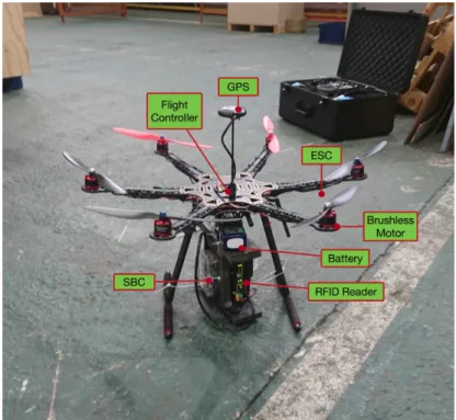
Figure3depicts the main components of the designed UAV, while Table3shows a summary of their characteristics. A multipurpose UAV was designed with both indoor and outdoor flight capabilities in order to extend its use to different applications and maximize its exploitation opportunities. The chosen configuration offers a good trade-off between cost, payload capacity and reliability; an hexacopter configuration has the minimum number of motors in order to be able to recover and land in the case of a motor failure without damaging people or goods. More rotors would increase the reliability even further but would also increase the cost and its total weight.
Specifically, the UAV is mounted on an hexacopter frame of 550 mm of diameter mostly made out of carbon fiber except for the arms, which are made of plastic reinforced by carbon fiber rods in the interior. The flight controller is a PixHawk 2.4.8 that has been flashed with the well-known open-source firmware Ardupilot [73] The thrust to move the UAV is generated by six 920 Kv brushless motors controlled by six 30 A Electronic Speed Control (ESCs), which are powered by a four-cell 5 Ah Li-Po battery that also provides power to all the on-board electronics through a voltage conversion module. Besides the built-in sensors of the flight controller board, a UBLOX M8N GPS module was included to enable outdoor autonomous flights since in this industrial use case, there are storage areas outdoors in a nearby dock next to the warehouse where inventory can also be performed.
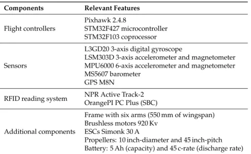
Table 3.Main features of the UAV components.
Components Relevant Features
Pixhawk 2.4.8
STM32F427 microcontroller Flight controllers
STM32F103 coprocessor
Sensors
L3GD20 3-axis digital gyroscope
LSM303D 3-axis accelerometer and magnetometer MPU6000 6-axis accelerometer and magnetometer MS5607 barometer
GPS M8N
NPR Active Track-2 RFID reading system
OrangePI PC Plus (SBC)
Additional components
Frame with six arms (550 mm of wingspan) Brushless motors 920 Kv
ESCs Simonk 30 A
Propellers: 10 inch-diameter and 45 inch-pitch Battery: 5 Ah (capacity) and 45 c-rate (discharge rate)
4.2. Implemented Architecture
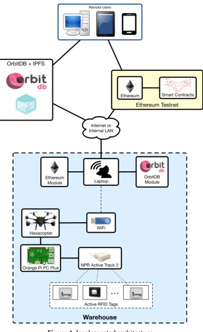
Figure4shows the actual implemented architecture of the proposed system. It can be observed that it is very similar to Figure2, but, since this article is focused on assessing the performance of the UAV-based inventory system, it includes certain simplifications on aspects that are not evaluated (i.e., on the CPS).
As it can be observed in Figures3and4, in order to perform the inventory, an RFID reader (NPR Active Track-2) is carried by the hexacopter. Specifically, active Ultra High Frequency (UHF) RFID has been selected as item identification technology due to its performance in environments with multiple metallic obstacles [26]. The RFID reader has been modified to reduce its weight by replacing its steel case with a lighter one made of foam, which protects the reader and reduces vibrations. In addition, it is worth pointing out that, as it can be observed in Figure3, the RFID reader antennas were placed as far as possible from the hexacopter propellers, which can influence communications performance. Nonetheless, the location of the antennas may be further optimized.
Regarding the used RFID tags, they are active UHF tags from RF-Code [74] that can be read with the NPR Active Track 2 reader (e.g., Active Rugged Tag-175S). Such a reader is connected through an Ethernet cable to the SBC. The tag UIDs collected by the SBC are first stored locally in a JavaScript Object Notation (JSON) file and then sent through WiFi to the ground station server, which, for the experiments performed in this article, it was run in a laptop.
Figure4shows a high-level view of the implemented blockchain-based architecture. As it can be observed in the Figure, to persist the collected inventory data, the proposed system makes use of the decentralized database OrbitDB [75], which runs over InterPlanetary File System (IPFS) [76]. IPFS provides a high throughput content-addressed block storage model with content-addressed hyper links. This forms a generalized Merkle Directed Acyclic Graph (DAG), a data structure upon which one can build versioned file systems, blockchains, and even a Permanent Web. Specifically, the main features of IPFS are:
• It keeps every version of the files, making it simple to set up resilient networks.
• It removes duplication across the network, therefore saving in storage. Each network node stores only content it is interested in and some indexing information that helps to figure out who is storing what.
• Every file can be found in an user-friendly way (e.g., by human-readable names) using a decentralized naming system called Inter-Planetary Name System (IPNS).
• It has no single point of failure and nodes do not need to trust each other.
Warehouse NPR Active Track 2
WiFi Hexacopter
Laptop Internet or Internal LAN
Orange Pi PC Plus
Active RFID Tags
…
Remote Users
Ethereum Module
Ethereum Testnet
Smart Contracts Ethereum
OrbitDB + IPFS
OrbitDB Module
Figure 4.Implemented architecture.
OrbitDB is built on top of IPFS to create a serverless, distributed, peer-to-peer database in alpha-stage software. It uses IPFS as its data storage, as well as IPFS Pubsub to synchronize databases with peers automatically. In addition, OrbitDB provides various types of databases for different data models and use cases:
• log: an immutable (append-only) log with traceable history. Useful for “latest N” use cases or as a message queue.
• lfeed: a mutable log with traceable history. Entries can be added and removed.
• docs: a document database where JSON documents can be stored and indexed by a specified key. Useful for building search indices or version controlling documents and data.
• counter: Useful for counting events separate from log/feed data.
All the previously mentioned types of databases are implemented on top of ipfs-log, an immutable, operation-based Conflict-free Replicated Data Structure (CRDT) for distributed systems. If none of the OrbitDB database types match a dApp needs or if a specific functionality is needed, it allows for implementing a custom database easily.
With respect to the blockchain, two different Ethereum testnets (i.e., test networks that are isolated from the public Ethereum blockchain [77]) were used: Rinkeby [78] and Ropsten [79]. Rinkeby is a Proof-of-Authority (PoA) testnet created by the Ethereum team that makes use of the Clique PoA consensus protocol, where authorized signers are responsible for minting the blocks. In such a network blocks are created on average every 15 s and Ether cannot be mined (it is requested through a faucet [80]). In contrast, Ropsten is a Proof-of-Work (PoW) Ethereum testnet where Ether can be either mined or requested from a faucet [81]. Ropsten’s blocks are usually minted in less than 30 s and, although the testnet reproduces with more fidelity than Rinkeby Ethereum’s mainnet production environment, it is prone to Denial-of-Service (DoS) attacks (e.g., by increasing the block gas limit remarkably while sending large transactions through the network), which makes synchronization slow and makes clients consume a lot of disk space. Rinkeby and Ropsten testnets allow for executing smart contracts (compiled and deployed through Truffle [82]), which store in a string the JSON file with the inventory data and its hash, so the blockchain acts both as a immutable log and as a timestamping server.
In the implemented architecture, remote users are able to access the raw OrbitDB and Ethereum data, but, thanks to the proposed architecture, it is straightforward to develop a backend that collects data from OrbitDB and Ethereum, and presents them through a frontend.
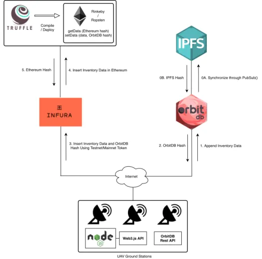
4.3. Inventory Data Insertion and Reading Processes
Figure5illustrates all the components that are involved in the implementation of the part the architecture related to decentralized storage and the blockchain. Besides the previously mentioned components (i.e., OrbitDB, IPFS, the Ethereum testnets and Truffle), three another elements are used:
• Infura [83]: it provides an easy to use HTTP API for accessing Ethereum that can be even implemented by resource-constraint IoT devices.
• Node.js [84]: it is an open-source platform that allows for executing JavaScript code outside of a browser.
• Web3 Javascript API [85]: It is a collection of libraries that allow for interacting with Ethereum nodes. In the proposed architecture, the Web3 API is called from a Node.js instance that exchanges requests that are handled by Infura.
execute the setData function of the smart contract, so that it updates the stored inventory data values and the OrbitDB hash. As a result of this operation, Ethereum returns a hash that can be used later to request the blockchain transaction information.
main
getData (Ethereum hash) setData (data, OrbitDB hash)
Rinkeby / Ropsten Compile
/ Deploy
1. Append Inventory Data 2. OrbitDB Hash
Internet
UAV Ground Stations
Web3.js API OrbitDB Rest API
3. Insert Inventory Data and OrbitDB Hash Using Testnet/Mainnet Token 4. Insert Inventory Data in Ethereum 5. Ethereum Hash
0A. Synchronize through PubSub() 0B. IPFS Hash
Figure 5.Inventory data insertion process and implemented architecture.
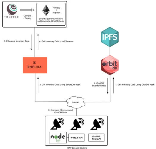
Figure6illustrates the steps required by an entity that wants to verify that the data stored in OrbitDB have not being altered after their insertion. In such a case, the entity only would need to first request the inventory data from OrbitDB and them perform through Infura aGetDatarequest to the corresponding Ethereum’s smart contract, which would return the inventory information stored on the blockchain and its OrbitDB hash. Then, the entity would only need to compare the inventory information collected from OrbitDB with the one from Ethereum, and determine whether it has been modified.
As it can be concluded from the proposed architecture and processes, they enable data trustworthiness through four different mechanisms:
• Information integrity can be verified by checking its hash. In addition, Ethereum and OrbitDB act as timestamping services, so it can be easily verified when the data were inserted.
• Since the data stored on the blockchain cannot be tampered without leaving a trace, the authenticity of the inventory information stored on OrbitDB can be easily checked.
• Every user transaction within OrbitDB is protected by asymmetric cryptography mechanisms that
• Similarly, the data that is exchanged with Ethereum are managed by Infura, which protects them through an API key and a secret key.
main
getData (Ethereum hash) setData (data, OrbitDB hash)
Rinkeby / Ropsten Compile
/ Deploy
1. Get Inventory Data Using OrbitDB Hash 2. OrbitDB
Inventory Data
Internet
UAV Ground Stations
Web3.js API Rest API OrbitDB
3. Get Inventory Data Using Ethereum Hash 4. Get Inventory Data from Ethereum 5. Ethereum Inventory Data
6. Compare Ethereum and OrbitDB Data
Figure 6.Inventory data verification process.
5. Experiments
5.1. Experimental Scenario
In order to evaluate the proposed system, it was tested in a big industrial warehouse that is shown in Figure7. The warehouse is approximately 120 m long and 40 m wide, but, due to security reasons (the warehouse was in operation during the experiments), the tags were deployed in an isolated subarea of 50 m×40 m.
Figure 7.Warehouse where the experiments were performed.
Plastic Packaging
RFID Tag
Metal Case
RFID Tag Wooden Box
RFID Tag
Figure 8.Warehouse material diversity.
Ground Station UAV
RFID Tags
Figure 9.Ground station setup.
UAV RFID Tags
UAV Controller
Figure 10.One of the instants during the inventory tests.
5.2. Inventory Time
The firsts tests were carried out in order to determine how fast the inventory data could be collected. Figure11shows the percentage of read tags through time for four different tests. During such tests the tags remained at the same location and were attached to the same items. Considering the nature of the proposed experiments and the RFID reader reading range, the pilot experience and skills can be considered negligible in the results obtained.
Figure 11.Percentage of read tags during four inventory flights.
Table 4.Example of the collected inventory data.
# Read Tags % Read Tags Timestamp (HH:MM:SS,ms) New Read Tag ID
0 0 18:14:43,087 (Take-off time)
1 7.692307692 18:14:46,058 LOCATE00380349
2 15.38461538 18:14:46,090 RFCBDG00011185
3 23.07692308 18:14:48,558 LOCATE00380364
4 30.76923077 18:14:48,589 RFCBDG00011185
5 38.46153846 18:14:52,748 LOCATE00380372
6 46.15384615 18:14:54,349 LOCATE00380349
7 53.84615385 18:14:57,129 RFCBDG00011188
8 61.53846154 18:15:11,403 LOCATE00380330
9 69.23076923 18:15:33,008 LOCATE00365573
10 76.92307692 18:15:49,288 LOCATE00375358
11 84.61538462 18:15:56,454 LOCATE00380359
12 92.30769231 18:15:56,456 LOCATE00380357
13 100 18:16:01,630 LOCATE00375356
During Tests 1 and 2, the drone departed from the same spot and followed a similar path. This can be observed in Figure11: the curves for both tests are very similar. Nonetheless, the inventory was gathered faster during Test 2: it only took approximately 78 s to collect the data, which is less than the 116 s needed during Test 1.
Except for Test 3 (due to its specific location), in the other cases, mainly because of the reading range and the omni-directional antennas of the reader, during the first 11 s (as the drone rose from the ground), it was possible to read roughly 30% of the tags. Moreover, in all tests, 50% of the items where inventoried in less than a minute and all of them in less than four minutes. These results are really promising, since the time required by a human operator to collect the same information is far greater than when using the proposed UAV-based system (the operator needs to walk through the area, locate the items and identify them manually).
5.3. Signal Strength Monitoring
As the drone hovers above the warehouse, besides tag UIDs, it also collects the Signal Strength Indicator (SSI) of such tags, which can potentially be used for locating industrial items and for creating signal strength maps [86].
An example of the SSI fluctuation perceived by the drone for one of the RFID tags during an inventory flight is shown in Figure12. It can be observed that while the drone is hovering around the warehouse, in locations far from the tag, the collected SSIs fluctuate between−50 and−62 dBm. However, once the drone is close to the tag, SSI levels go up to around−40 dBm and, as the drone moves away from the tag, the collected SSI values go down again to be between−50 and−62 dBm. Therefore, if the location of the drone can be obtained through an indoor positioning system, due to the existent correlation, tag locations may be estimated at the same time as the inventory data are collected. However, it must be noted that, in order to design an indoor positioning system for industrial environments, additional factors should be considered, like the reflections, diffraction and refraction caused by surrounding materials, the presence of hostile electromagnetic sources, certain features of the scenario (e.g., presence of metals, water, exposure to liquids, acids, salinity, fuel or other corrosive substances, tolerance to high temperatures) or the actual reading distance, among others [26].
Finally, it is worth pointing out that just after flying over the tag there were several seconds (roughly between seconds 120 and 160) during which the tag SSIs were not received by the UAV, what was probably caused by a signal blockage related to the presence of large metallic item in the scenario. This must be taken into account in future developments in order to determine the optimal tag and item positions to maximize SSI reception.
Flying over Tag
5.4. Performance of the Implemented Architecture
5.4.1. Performance of the Decentralized Database
The performance of OrbitDB was measured in terms of response latency (i.e., how fast the inventory data were inserted into OrbitDB after being sent by a UAV ground station). Three scenarios (named A, B and C) were simulated in order to evaluate the effect of payload size and network delay, so small, medium and large payloads were sent to OrbitDB when it was running either in the same Intranet (i.e., the same private local network) as the ground station, and when it was running in a remote cloud on the Internet (i.e., for simulating the connection with other stakeholders such as suppliers or external audits). As a reference, it can be indicated that the minimum/average/maximum round-trip times to the machine that ran OrbitDB in the Intranet were 0.935/1.034/1.695 ms, while the same values for the connection between the ground station and the remote cloud were 37.948/39.362/51.172 ms. Scenarios A, B and C take place inside an Intranet. Scenario A corresponds exactly to the environment tested in Section5.2: the inventory data were only 13 Tag IDs, which derived into a very small payload (around 1 KB). Scenarios B and C simulate inventory data of 5000 (around 30 KB) and 10,000 (around 67 KB) items, respectively. Regarding Scenarios D, E and F, they also simulate 13, 5000 and 10,000 items, respectively, but the inventory data is sent from the local network to a remote OrbitDB instance that runs on a cloud on the Internet.
These scenarios resulted into the six use cases characterized in Table5, which shows, for each scenario, the number of inventoried tags, as well as the mean and variance of the obtained OrbitdB response latency. In addition, Figures13and14show the response latency for the six evaluated scenarios and for 2000 insertion requests per scenario when measuring the time elapsed since each request is issued, until the OrbitDB hash is obtained (i.e., from step 1 to step 2 of Figure5).
Table 5.Mean and variance of the use cases considered in the OrbitDB performance test.
# Tag IDs/Network Intranet Internet
13 Scenario A:µ: 0.1576 s;σ2: 0.0039 s Scenario D:µ: 0.3648 s;σ2: 0.0114 s 5000 Scenario B:µ: 0.1669 s;σ2: 0.0032 s Scenario E:µ: 0.5063 s;σ2: 0.0265 s 10,000 Scenario C:µ: 0.1892 s;σ2:0.0049 s Scenario F:µ: 0.5553 s;σ2: 0.0093 s
The results show that, in terms of response delay, OrbitDB insertions are really fast: in the worst tested case (Scenario F), the average inventory data insertion time requires roughly 0.55 s. In addition, it can be pointed out that, as expected, the larger the payload, the slower the insertion. However, the difference in response delay between the insertion of 13 and 10,000 tag IDs is negligible when OrbitDB runs on the Intranet (only 31.6 ms), while, in the same case but when OrbitDB was running of the remote cloud, the difference rose up to 190.5 ms. Moreover, at the view of the low variance values, it can be observed that response delay is very stable in both networks, although, obviously, it is clearly more stable for Scenarios A, B and C (i.e., on the Intranet).
and then generate artificial samples from the fitted distributions to perform Monte Carlo simulations to test the theoretical load that can be supported by the proposed system.
0 250 500 750 1000 1250 1500 1750 2000 #Request
0 250 500 750 1000 1250 1500 1750 2000 #Request
0 250 500 750 1000 1250 1500 1750 2000 #Request
0 250 500 750 1000 1250 1500 1750 2000 #Request
0 250 500 750 1000 1250 1500 1750 2000 #Request
0.2 0.4 0.6 0.8 1 1.2
Figure 15.Probability Density Function (pdf) in OrbitDB for (A) Scenario A, (B) Scenario B and (C) Scenario C.
0.5 0.6 0.7 0.8 0.9 1 1.1 Time (s)
0 1 2 3 4 5 6 7
Density
Scenario F
Non-parametric (kernel=normal, bandwidth= 0.0231413)
(C)
Figure 16. Probability Density Function (pdf) in OrbitDB for (A) Scenario D, (B) Scenario E and (C)
Scenario F.
5.4.2. Performance of The Blockchain
It is also interesting to measure the blockchain response latency in order to detect a possible bottleneck of the architecture. While Rinkeby is a PoA testnet whose time to mint a block is set to an average of 15 s, the Ropsten testnet is based on PoW and thus the same time may vary noticeably.
Figure17shows the response latency of almost 100 transactions (9.4 KB) in the Ropsten testnet during a smart contract update of the proposed system. Specifically, the elapsed time is measured since the transaction is included in a block until it is validated (from step 3 to step 5 in Figure5). As it can be observed in Figure17, the response time varies significantly from less to 5 s up to more than 70 s, being the delays significantly higher than in the OrbitDB performance tests.
0
20
40
60
80
100
#Request
0
10
20
30
40
50
60
70
Tim
e (
s)
Figure 17.Ropsten testnet time response.
transactions, the addresses of the involved parties and the number of miners. Additional details are available onhttps://ropsten.etherscan.io/address/0x3a99afac4a32b29c17aeb7d0b4e3c4f28ea200c7.
Figure 18.Caption of Ropsten Testnet transactions.
6. Conclusions
Supplementary Materials:The following video is available online athttp://www.mdpi.com/1424-8220/19/10/239 4/s1, Video S1: Blockchain-based UAV performing a warehouse inventory.
Author Contributions: T.M.F.-C. and P.F.-L. conceived and designed the system; O.B.-N. built the drone, O.B.-N.,
T.M.F.-C., I.F.-M. and P.F.-L. performed the experiments; P.F.-L. and T.M.F.-C. wrote the paper.
Funding:This work has been funded by the Xunta de Galicia (ED431C 2016-045, ED431G/01), Centro singular de
investigación de Galicia accreditation 2016-2019 through the CONCORDANCE (Collision avOidaNCe fOR UAVs using Deep leArNing teChniques and optimized sEnsor design) project, the Agencia Estatal de Investigación of Spain (TEC2016-75067-C4-1-R) and ERDF funds of the EU (AEI/FEDER, UE).
Conflicts of Interest:The authors declare no conflict of interest.
References
1. Qi, Q.; Tao, F. Digital Twin and Big Data Towards Smart Manufacturing and Industry 4.0: 360 Degree Comparison.
IEEE Access2018,6, 3585–3593. [CrossRef]
2. Blanco-Novoa, Ó.; Fernández-Caramés, T.M.; Fraga-Lamas, P.; Vilar-Montesinos, M.A. A Practical Evaluation of Commercial Industrial Augmented Reality Systems in an Industry 4.0 Shipyard.IEEE Access2018,6, 8201–8218. [CrossRef]
3. Wohlgemuth, W.; Triebfürst, G. ARVIKA: Augmented Reality for development, production and service. In Proceedings of the DARE 2000, Elsinore, Denmark, 12–14 April 2000.
4. Friedrich, W. ARVIKA-Augmented Reality for Development, Production and Service. In Proceedings of the International Symposium on Mixed and Augmented Reality, Darmstadt, Germany, 30 September–1 October 2002; pp. 3–4.
5. Fraga-Lamas, P.; Fernández-Caramés, T.M.; Blanco-Novoa, Ó.; Vilar-Montesinos, M.A. A Review on Industrial Augmented Reality Systems for the Industry 4.0 Shipyard.IEEE Access2018,6, 13358–13375. [CrossRef] 6. Robla-Gómez, S.; Becerra, V.M.; Llata, J.R.; González-Sarabia, E.; Torre-Ferrero, C.; Pérez-Oria, J. Working
Together: A Review on Safe Human-Robot Collaboration in Industrial Environments. IEEE Access 2017,
5, 26754–26773. [CrossRef]
7. Fernández-Caramés, T.M.; Fraga-Lamas, P.; Suárez-Albela, M.; Díaz-Bouza, M.A. A Fog Computing Based Cyber-Physical System for the Automation of Pipe-Related Tasks in the Industry 4.0 Shipyard. Sensors2018,
18, 1961. [CrossRef]
8. Bonomi, F.; Milito, R.; Zhu, J.; Addepalli, S. Fog Computing and its Role in the Internet of Things. In Proceedings of the First Edition of the MCC Workshop on Mobile Cloud Computing, Helsinki, Finland, 13–17 August 2012; pp. 13–16.
9. Fernández-Caramés, T.M.; Fraga-Lamas, P.; Suárez-Albela, M.; Vilar-Montesinos, M. A Fog Computing and Cloudlet Based Augmented Reality System for the Industry 4.0 Shipyard. Sensors2018,18, 1798. [CrossRef] 10. Xu, L.D.; He, W.; Li, S. Internet of Things in Industries: A Survey. IEEE Trans. Ind. Inform.2014,10, 2233–2243.
[CrossRef]
11. Wang, G.; Gunasekaran, A.; Ngai, E.W.; Papadopoulos, T. Big data analytics in logistics and supply chain management: Certain investigations for research and applications. Int. J. Prod. Econ. 2016, 176, 98–110. [CrossRef]
12. Shakhatreh, H.; Sawalmeh, A.; Al-Fuqaha, A.I.; Dou, Z.; Almaita, E.; Khalil, I.M.; Othman, N.S.; Khreishah, A.; Guizani, M. Unmanned Aerial Vehicles: A Survey on Civil Applications and Key Research Challenges.arXiv2018, arXiv:1805.00881.
13. Hassanalian, M.; Abdelkefi, A. Classifications, applications, and design challenges of drones: A review.
Prog. Aerosp. Sci.2017,91, 99–131. [CrossRef]
14. Hardis Group, EyeSee Official Webpage. Available online: http://www.eyesee-drone.com(accessed on 31 March 2019).
16. DroneScan Official Webpage. Available online:www.dronescan.co(accessed on 31 March 2019).
17. Beul, M.; Droeschel, D.; Nieuwenhuisen, M.; Quenzel, J.; Houben, S.; Behnke, S. Fast Autonomous Flight in Warehouses for Inventory Applications. IEEE Robot. Autom. Lett.2018,3, 3121–3128. [CrossRef]
18. Fraga-Lamas, P.; Fernández-Caramés, T.M. A Review on Blockchain Technologies for an Advanced and Cyber-Resilient Automotive Industry.IEEE Access2019,7, 17578–17598. [CrossRef]
19. Fu, Y.; Zhu, J. Big Production Enterprise Supply Chain Endogenous Risk Management Based on Blockchain.
IEEE Access2019,7, 15310–15319. [CrossRef]
20. Fernández-Caramés, T.M.; Fraga-Lamas, P. A Review on the Use of Blockchain for the Internet of Things.
IEEE Access2018,6, 32979–33001. [CrossRef]
21. Fernández-Caramés, T. M.; Fraga-Lamas, P. A Review on the Application of Blockchain for the Next Generation of Cybersecure Industry 4.0 Smart Factories.IEEE Access2019,7, 45201–45218. [CrossRef]
22. Yu, B.; Wright, J.; Nepal, S.; Zhu, L.; Liu, J.; Ranjan, R. IoTChain: Establishing Trust in the Internet of Things Ecosystem Using Blockchain. IEEE Cloud Comput.2018,5, 12–23. [CrossRef]
23. Kapitonov, A.; Lonshakov, S.; Krupenkin, A.; Berman, I. Blockchain-based protocol of autonomous business activity for multi-agent systems consisting of UAVs. In Proceedings of the 2017 Workshop on Research, Education and Development of Unmanned Aerial Systems (RED-UAS), Linkoping, Sweden, 3–5 October 2017; pp. 84–89. 24. Global Trade Item Number Official Web Page at GS1 Website. Available online: https://www.gs1.org/gtin
(accessed on 31 March 2019).
25. Finkenzeller, K.RFID Handbook: Fundamentals and Applications in Contactless Smart Cards and Identification, 3rd ed.; John Wiley & Sons: Hoboken, NJ, USA, 2003.
26. Fraga-Lamas, P.; Noceda-Davila, D.; Fernández-Caramés, T.M.; Díaz-Bouza, M.; Vilar-Montesinos, M. Smart Pipe System for a Shipyard 4.0. Sensors2016,16, 2186. [CrossRef] [PubMed]
27. Ganesan, R.; Krumm, J.; Pankalla, S.; Ludwig, K.; Glesner, M. Design of an organic electronic label on a flexible substrate for temperature sensing. In Proceedings of the ESSCIRC, Bucharest, Romania, 16–20 September 2013. 28. Todd, B.; Phillips, M.; Schultz, S.M.; Hawkins, A.R.; Jensen, B.D. RFID threshold accelerometer. In Proceedings
of the IEEE AUTOTESTCON, Salt Lake City, UT, USA, 8–11 September 2008.
29. Amin, E.M.; Bhattacharyya, R.; Sarma, S.; Karmakar, N.C. Chipless RFID tag for light sensing. In Proceedings of the IEEE Antennas and Propagation Society International Symposium, Memphis, TN, USA, 6–11 July 2014. 30. Fernández-Caramés, T.M.; Fraga-Lamas, P. A Review on Human-Centered IoT-Connected Smart Labels for the
Industry 4.0. IEEE Access2018,6, 25939–25957. [CrossRef]
31. Fraga-Lamas, P.; Fernández-Caramés, T.M.; Noceda-Davila, D.; Díaz-Bouza, M.; Vilar-Montesinos, M.; Pena-Agras, J.D.; Castedo, L. Enabling automatic event detection for the pipe workshop of the shipyard 4.0. In Proceedings of the 2017 56th FITCE Congress, Madrid, Spain, 14–16 September 2017; pp. 20–27.
32. ProVIEW Smart Label Official Web Page. Available online:https://www.omni-id.com/rfid-in-manufacturing/ (accessed on 31 March 2019).
33. Coksun, V.; Ok, K.; Ozdenizci, B.Near Field Communications: From Theory to Practice, 1st ed.; John Wiley & Sons: Hoboken, NJ, USA, 2012.
34. Held, I.; Chen, A. Channel Estimation and Equalization Algorithms for Long Range Bluetooth Signal Reception. In Proceedings of the IEEE Vehicular Technology Conference, Taipei, Taiwan, 16–19 May 2010.
35. Fernández-Caramés, T.M., Rodas, J., Escudero, C.J., Iglesia, D.I. Bluetooth Sensor Network Positioning System with Dynamic Calibration. In Proceedings of the International Symposium on Wireless Communications Systems, Trondheim, Norway, 17–19 October 2007.
36. Rodas, J.; Fernández-Caramés, T.M.; Escudero, C.J.; Iglesia, D.I. Multiple Antennas Bluetooth System for RSSI Stabilization. In Proceedings of the International Symposium on Wireless Communications Systems, Trondheim, Norway, 17–19 October 2007.
38. Hernández-Rojas, D.L.; Fernández-Caramés, T.M.; Fraga-Lamas, P.; Escudero, C.J. Design and Practical Evaluation of a Family of Lightweight Protocols for Heterogeneous Sensing through BLE Beacons in IoT Telemetry Applications. Sensors2017,18, 57. [CrossRef]
39. Fernández-Caramés, T.M.; González-López, M.; Castedo, L. FPGA-based vehicular channel emulator for real-time performance evaluation of IEEE 802.11 p transceivers. EURASIP J. Wirel. Commun. Netw.2010,2010, 607467. [CrossRef]
40. Fernández-Caramés, T.M.; González-López, M.; Castedo, L. FPGA-based vehicular channel emulator for evaluation of IEEE 802.11p transceivers. In Proceedings of the International Conference on Intelligent Transport Systems Telecommunications, Lille, France, 20–22 October 2009.
41. ZigBee Alliance. Available online:http://www.zigbee.org(accessed on 31 March 2019).
42. Khutsoane, O.; Isong, B.; Abu-Mahfouz, A.M. IoT devices and applications based on LoRa/LoRaWAN. In Proceedings of the Annual Conference of the IEEE Industrial Electronics Society, Beijing, China, 29 October–1 November 2017. 43. Weyn, M.; Ergeerts, G.; Berkvens, R.; Wojciechowski, B.; Tabakov, Y. DASH7 alliance protocol 1.0: Low-power,
mid-range sensor and actuator communication. In Proceedings of the IEEE Conference on Standards for Communications and Networking (CSCN), Tokyo, Japan, 28–30 October 2015.
44. Kim, A.N.; Hekland, F.; Petersen, S.; Doyle, P. When HART goes wireless: Understanding and implementing the WirelessHART standard. In Proceedings of the IEEE International Conference on Emerging Technologies and Factory Automation, Hamburg, Germany, 15–18 September 2008.
45. SigFox Official Web Page. Available online:https://www.sigfox.com(accessed on 31 March 2019).
46. ANT Wireless Official Web Page. Available online:https://www.thisisant.com(accessed on 31 March 2019). 47. Lu, J.; Xu, X.; Li, X.; Li, L.; Chang, C.-C.; Feng, X.; Zhang, S. Detection of Bird’s Nest in High Power Lines in the
Vicinity of Remote Campus Based on Combination Features and Cascade Classifier.IEEE Access2018,6, 39063–39071. [CrossRef]
48. Zhou, Z.; Zhang, C.; Xu, C.; Xiong, F.; Zhang, Y.; Umer, T. Energy-Efficient Industrial Internet of UAVs for Power Line Inspection in Smart Grid.IEEE Trans. Ind. Inform.2018,14, 2705–2714. [CrossRef]
49. Lim, G.J.; Kim, S.; Cho, J.; Gong, Y.; Khodaei, A. Multi-UAV Pre-Positioning and Routing for Power Network Damage Assessment.IEEE Trans. Smart Grid2018,9, 3643–3651. [CrossRef]
50. Wang, L.; Zhang, Z. Automatic Detection of Wind Turbine Blade Surface Cracks Based on UAV-Taken Images.
IEEE Trans. Ind. Electron.2017,64, 7293–7303. [CrossRef]
51. Peng, K.; Liu, W.; Sun, Q.; Ma, X.; Hu, M.; Wang, D.; Liu, J. Wide-Area Vehicle-Drone Cooperative Sensing: Opportunities and Approaches.IEEE Access2018,7, 1818–1828. [CrossRef]
52. Rossi, M.; Brunelli, D. Autonomous Gas Detection and Mapping with Unmanned Aerial Vehicles.IEEE Trans.
Instrum. Meas.2016,65, 765–775. [CrossRef]
53. Scilimati, V.; Petitti, A.; Boccadoro, P.; Colella, R.; Di Paola, D.; Milella, A.; Grieco, L.A. Industrial Internet of things at work: A case study analysis in robotic-aided environmental monitoring.IET Wirel. Sens. Syst.2017,7, 155–162. [CrossRef]
54. Misra, P.; Kumar, A.A.; Mohapatra, P.; Balamuralidhar, P. Aerial Drones with Location-Sensitive Ears.
IEEE Commun. Mag.2018,56, 154–160. [CrossRef]
55. Li, H.; Savkin, A.V. Wireless Sensor Network Based Navigation of Micro Flying Robots in the Industrial Internet of Things.IEEE Trans. Ind. Inform.2018,14, 3524–3533. [CrossRef]
56. Olivares, V.; Córdova, F. Evaluation by computer simulation of the operation of a fleet of drones for transporting materials in a manufacturing plant of plastic products. In Proceedings of the 2015 CHILEAN Conference on Electrical, Electronics Engineering, Information and Communication Technologies (CHILECON), Santiago, Chile, 28–30 October 2015; pp. 847–853.
57. Zhao, S.; Hu, Z.; Yin, M.; Ang, K.Z.Y.; Liu, P.; Wang, F.; Dong, X.; Lin, F.; Chen, B.M.; Lee, T.H. A Robust Real-Time Vision System for Autonomous Cargo Transfer by an Unmanned Helicopter.IEEE Trans. Ind. Electron. 2015,62, 1210–1219. [CrossRef]