Precision Agriculture
without borders
: Practical issues and
improvements in farmland coverage with aerial vehicles
Jo˜ao Valente, Antonio Barrientos, Jaime del Cerro, David Sanz, Mario Garz´on, and Claudio Rossi
Robotics & Cybernetics Research Group (CAR UPM-CSIC)
Madrid, Spain,
Abstract
This work presents a solution for the aerial coverage of a field by using a fleet of aerial vehicles. The use of Unmanned Aerial Vehicles allows to obtain high resolution mosaics to be used in Precision Agriculture tech-niques.
This report is focus on providing a solution for the full simultaneous coverage problem taking into account restrictions as the required spatial resolution and overlap while maintaining similar light conditions and safety operation of the drones. Results obtained from real field tests are finally reported.
keywords: Quad-rotors, Coverage Path Planning, Precision Agriculture, Remote Sensing
1
INTRODUCTION
In recent years, precision agriculture (PA) researchers have found that the use of unmanned aerial vehicles (UAV)
based on quad-rotors could significantly help to improve the agricultural sciences research. Their motivation
was conceived by its availability, simple assemblage and maintenance, as well as their low cost compared with
traditional tools (e.g. Satellites or conventional aircrafts). For this reason, significant efforts are being made to use
a new generation of mini unmanned aerial vehicles (mUAV) to perform remote sensing (RS).
The main aim of an aerial survey is to obtain aerial images of the field, that can be used to generate a map of
the surface though mosaicking procedures, those maps can also be post-processed to extract interesting
informa-tion(e.g. biophysical parameters, shape and features detection).
Therefore, the aerial vehicles have to cover the full area to be surveyed by following a continuous and smooth
trajectory and avoiding obstacles or prohibited areas. In order ensure a minimum completion time for the survey,
it is desirable to minimize the number of changes in direction and to avoid revisiting points. Furthermore, not all
areas are suitable for taking off or landing with aerial vehicles, so the trajectory has to ensure starting and ending
accessibility). The problem of covering an entire area, subjected to constraints established by the platform itself
and by the workspace, is known as the coverage path planning (CPP) issue.
Aerial robots are mainly employed in agriculture for crop observation and map generation through imaging
surveys [2, 1, 6]. The maps are usually built by stitching a set of georeferenced images (i.e. orthophotos) through
mosaicking procedures. Typically, they rely on information about the biophysical parameters of the crop field.
Moreover, the agricultural experiments reported with aerial vehicles fall mainly in waypoints based navigation
[2, 7, 3], where the drones navigate autonomously through a predefined trajectory, composed by a set of points in
the environment.
This paper gives an overview about some practical aspects of coverage missions for agricultural sites using
single or multi aerial robot systems. A set of metrics have been proposed in order to evaluate those robotic
systems and make a comparative analysis between them. The metrics are mostly focused on the mission time, the
percentage of area covered, and the human effort in each mission, moreover, a Risk Analysis (RA) is presented to
study the possibility of improving the total area coverage by a fleet of aerial vehicles.
The organization of the paper is as follows: After this brief introduction, Section 2 introduces the conceptual
aerial framework with all their components and workload. Section 3 present the field trials with single and multi
aerial robots, while Section 4 provides an improvement approach for coverage mission with multi aerial robots,
and finally in Section 5 the issues reviewed are summed up .
2
AERIAL FRAMEWORK
The conceptual aerial framework is denoted as a set of actions and components (i.e. software and hardware) that
provide the achievement of a task inside a determinate context in a feasible fashion. Hence, the framework intends
to support area coverage missions with aerial robotic systems in PA practices. This is a preliminary phase in the
design of a robotic system that can be seen as a top-down approach to solve the problem (i.e. through a step-wise
design). Abstractly speaking: Break up the overall goal, individualize the requirements, come up with a concept,
and finally start the design phase.
As it was introduced in section 1 there is an agricultural task demand and a fleet of aerial and ground robots to
carry out the proposed task. To make the concept description easier to follow, lets assume that there is a general
weed control task. This task fall mainly in two sub-tasks: the perception system (i.e. identify the weed species and
patches over a wide agricultural area) and the actuation system (i.e. kill the weeds). The second sub-task will not
be discussed in this thesis and it was almost not considered in the framework design.
In order to identify the weed species and patches, the agricultural field has to be previously surveyed with an
image sensor. In this way, the aerial framework will be responsible to address this operation.
The main components of the framework are: Aerial vehicles, Operation or Control station, and Mission planner.
The framework must be able to provide the operator in charge with the required tools to carry out the mission. This
compress an aerial vehicle with way-points navigation features, a visual sensor, a control station with tools to
for the mission are: Number of aerial units available, field map characteristics (e.g. coordinates, undesired areas),
and images resolution and overlapping. The step-by-step mission can be summed up in:
1. The aerial units and the control station are setup near the target agricultural site
2. The operator introduces the before mentioned inputs to the mission planner
3. The operator launches the mission planner
4. The mission planner computes an aerial trajectory and sends it to the operator
5. If the operator does not agree with the generated path, the procedure will jump back to 2.
6. Else, the plan is sent to the aerial vehicles, the execution starts, and the operator supervises the mission until
it is finished.
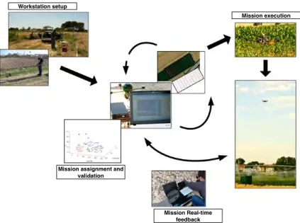
Figure 1 illustrate an abstract schematic of the mission procedures.
Workstation setup
Mission assignment and validation
Mission execution
Mission Real-time feedback
Figure 1: The mission procedures.
3
AERIAL COVERAGE IN PRACTICE
3.1
Case studies on agricultural scenarios
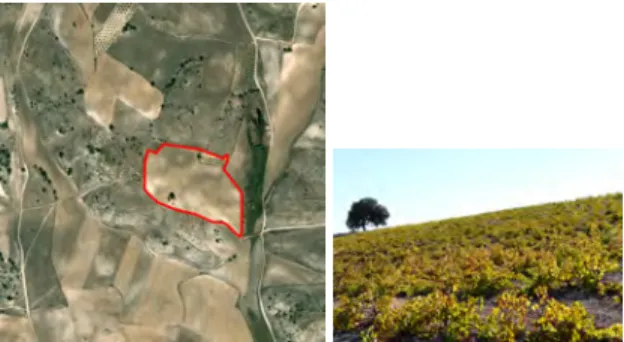
The test scenario was selected to agree with the current goals of the research group. In this way the effort was
made to select a crop field with an irregular shape in order to test the CPP algorithms in a general scenario. The
goal of this study is to develop a feasible mission planner dedicated to aerial vehicles to be part of the current
European project RHEA in which the group is participating. On the other hand, the opportunity to contribute
agricultural scenario to carry out the experiments was a vineyard located in Belmonte de Tajo, in the Northwest of
Madrid, Spain1. The agricultural field is enhanced with a red line in an orthophoto, see Figure 2.
Latitude Longitude Area
40◦06047.4300N 3◦17002.3300W 63765m2
Figure 2: Selected test field.
3.2
Performance Evaluation
In order to measure and evaluate the strategies employed four metrics were established: Number of Turns (Tu),
Quality of Service (QoS), Coverage Time (T), and Human Effort (He).
The metricTumeasures the number and type of rotations made by the aerial vehicle around the z-axis (yaw
turns). The function that measures this magnitude can be given as follow,
Γ = m
X
i=1
γk{i}, k∈ {135◦,90◦,45◦,0◦} (1)
where,
γ±135◦ > γ±90◦ > γ±45◦ > γ0◦ (2)
As previous mentioned, the raster borders will not be sampled. in addition to this, they are used to divide the
target area, and also employed as security strips for avoiding collisions during flight. An upper bound (UB) of
unvisited cells can be estimated for the security strips as follows: let the area to be discretized in aN×M grid,
N < M. The maximum number of bounding lines is equal to the number of robotsR, and the maximum length
of a line is equal to the diagonal. In a discrete world, the length in cells of the diagonal is equal toM. Then,
UB=
R·M N·M =
R
N. (3)
The valueUB/(N·M)(%)is referred as aQoSindex, since it actually indicates the percentage of the remote
sensed field.
Moreover, the metricTis the mission completion time in seconds, which indeed can be split in coverage time
Tcand setup timeTs, as follows,
T=Tc+Ts (4)
Finally, the metricHedenotes the number of qualified persons needed to carry out an aerial mission of this
kind.
3.3
Field trials
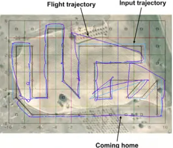
Figure 3 illustrates the coverage trajectory performed by the quad-rotor by a dark blue line and the desired trajectory
(i.e. path sent to the vehicle) by a light one. The desired trajectory presents some gaps, mainly points deviated
from the trajectory. This error was not produced by the system at all, since the computed trajectory is supervised
by a skilled operator before the flight survey. In this situation in particular what happen was that these deviations
have been considered, and therefore pointless to be discussed. For further details about the approach employed in
this experiment the reader is referred to [5].
Figure 3: Farmland coverage with a single aerial vehicle.
Metrics
Tu QoS Tc Ts He
21 100 500 220 2
Figure 4: Metrics from the experiment with a single aerial vehicle.
In each way-point the quad-rotor hovered for 1s with the purpose to simulate the camera shot. The results
obtained in the real coverage mission were the following: During the flight the quad-rotor hovered accurately over
73% of the computed way-points, therefore missing 27% of them. Nevertheless, the results obtained from the field
trials are enough to analyze the experiment. Table 4 summarize the measured metrics.
As far as the same experiments with multi robots is concerned, a coverage path was computed with the purpose
to cover the vineyards with three aerial vehicles. The reader is referred to [4] for a general understanding of the
methods applied. The experimental results are shown in Figure 5. Table 6 summarize the parameters setup and the
Figure 5: Farmland coverage with multi aerial vehicles
Metrics
Tu QoS Tc Ts He
A 9 - 183 283
-B 8 - 196 82
-C 20 - 288 313
-Total - 222 226 5
Figure 6: Metrics from the experiment with multi aerial vehicle.
3.4
Discussion
Taking the aforementioned field experiments into account, can be concluded that multi robot systems improve
significantly the mission completion time. Nevertheless, there are a couple of trade-offs that should be carefully
analyzed.
The first trade-off is between theQoSand the mission completion timeT. TheQoSis from 100% for an area
coverage with a single aerial vehicle, which mean that all area is full covered (i.e. major sampling). On the other
hand, when employing more than one aerial vehicle, the workspace is setup with security strips which are defined
as cells where the vehicles do not pass by. Therefore, the results from Figure 5 have a lack of 22% of area to be
covered. Nevertheless, a workaround for this issue is to send the first robot that finishes its trajectory to cover those
areas. However, this is not the most elegant solution.
Another relevant point is theHein both missions. From the previous experiments is obvious thatHeincreases
with the number of aerial units per mission. Therefore, there is a trade-off betweenTandHe, since the employment
of multiple robots means higher costs in terms of personal. It should be highlighted that each aerial robot hast to
have an experienced pilot and additionally there should be a ground base operator which supervises the mission. In
this sense, a pilot is in charge of supervising (and, if necessary, teleoperating) the UAVs, and a mission specialist
is in charge of supervising the mission. Indeed, the typical and safer modality is to have one person in charge
for each drone and one more person as mission operator. The pilots are responsible of supervising the mission
of each UAV from the ground and switch from automatic to manual mode in case there is some system failure or
emergency. The base-station operator is in charge of supervising the mission at a highest level (i.e. monitoring all
the navigation data in real time). Although there is not a specific safety regulation applied to mini aerial vehicles,
all the tends are in the line that this measure will be mandatory.
4
IMPROVING AREA COVERAGE
The rasterized borders represented in a multi robot workspace are meaningful, since they work as security strips,
area to cover when using them. The metric that address the percentage of area covered is theQoSindex. Therefore,
borders have to be considered so as to to improve theQoSbut at the same time safety for the robotic system has to
be ensured. A Risk Analysis (RA) has been carried out with the purpose of improving this index.
A risky situation is defined as a situation where two or more aerial robots are located in adjacent cells and
therefore, the distance between them is beyond a certain value. Lets denotePn(Xn, Yn, Zn)the 3-dimensional
position of anaerial robot in an aerial fleet withNelements. A risk condition can be written as,
∀n∈N, ∃∆n{i}≤δ, i= 1,2, ...j
whereiis the ith neighbor robot andjthe length of a certain neighborhood (e.g. the Von-Neumann
neighbor-hood has a maximum of 4 neighbor robots per robot). Finally,∆is the distance between the robotnand a neighbor
roboti, andδa stipulated minimum safety distance.
The first point to be analyzed is the number of occurrences found during a coverage trajectory (two or more
robot are in neighboring). From the analyses of 8 different coverage trajectories in 2 different crop fields (regular
shape maize fields (e.g. [4]) and non regular shape vineyards) it can be concluded that 37.5% of the times the
robot are in neighboring with other robot. Moreover, up to 12.5% of the times three robot are simultaneously in
neighboring. This non exhaustive analysis allowed to give an idea of the number of times that this situation occurs.
Secondly, lets suppose that a robot is adjacent to another (i.e. neighbor cells). For example, the vineyard has an
area of approximately 63765m2which corresponds to 195m length and 327m width. Lets assume that the aerial
robot carries a commercial digital camera that provides image resolutions up to 10.4 mega pixels. Moreover, if
choose the best image resolution to sample the field is chosen, it corresponds to an image size from 3368x3088
pixels. If the mission requires a certain percentage of overlapping, the effective size of the image will be reduce
in same percentage. If a spatial resolution of 1 pixel/cm is required, we will obtain a grid resolution of 6x10 cells
(each cell will have a dimension of 32.7x32.5m). 2 With these magnitudes it will be difficult to have a collision
between two aerial robots. Even considering positions uncertainties of 3m and wind speeds of 10m/s, there is no
possibility that two aerial robots collide.
In conclusion, whenever a coverage mission where the cells dimension are above a margin of 5m is considered,
the security strips from can be removed from the planner. Figure 7 shows the same coverage path computed in
Figure 5 but without borders, where the borders have been distributed to each sub-area in a load balancing fashion.
5
CONCLUSIONS
This paper highlights the importance of relying on a coverage path planning system for multiple aerial vehicles
with the ability of taking high-resolution images so as to create mosaics to be used in Precision Agriculture.
A CPP approach has been presented and tested considering safety limitations with three quad-rotors. Some
metrics for evaluating the coverage mission has been presented and discussed.
Figure 7: Multi robot coverage without borders
Tests have been performe ˆA ˆAd in real fields, considering no regular shapes with a fully autonomous planner for
several drones allowing 100% of coverage with no risk for the drones.
ACKNOWLEDGMENTS
This work have been supported by the Robotics and Cybernetics Research Group at Technique University of
Madrid (Spain), and funded under the projects “ROTOS: Multi-Robot system for outdoor infrastructures
protec-tion“, sponsored by Spain Ministry of Education and Science (DPI2010-17998), and ’Robot Fleets for Highly
Effective Agriculture and Forestry Management’, (RHEA) sponsored by the European Commission’s Seventh
Framework Programme (NMP-CP-IP 245986-2 RHEA). The authors want to thank all the project partners:
Agen-cia Estatal Consejo Superior de Investigaciones Cient´ıficas - CSIC (Centro de Autom´atica y Rob´otica, Instituto
de Ciencias Agrarias, Instituto de Agricultura Sostenible), CogVis GmbH, Forschungszentrum
Telekommunika-tion Wien Ltd., Cyberbotics Ltd, Universit`a di Pisa, Universidad Complutense de Madrid, Tropical, Soluciones
Agr´ıcolas de Precisi´on S.L., Universidad Polit´ecnica de Madrid - UPM (ETS Ingenieros Agr´onomos, ETS
Inge-nieros Industriales), AirRobot GmbH & Co. KG, Universit`a degli Studi di Firenze, Centre National du Machinisme
Agricole, du G´enie Rural, des Eaux et des For`ets -CEMAGREF, CNH Belgium NV, CNH France SA, Bluebotics
S.A. y CM Srl.
References
[1] S. R. Herwitz, L. F. Johnson, S. E. Dunagan, R. G. Higgins, D. V. Sullivan, J. Zheng, B. M. Lobitz, J. G.
Leung, B. A. Gallmeyer, M. Aoyagi, R. E. Slye, and J. A. Brass. Imaging from an unmanned aerial vehicle:
agricultural surveillance and decision support. Computers and Electronics in Agriculture, 44(1):49–61, 2004.
[2] L. F. Johnson, S. Herwitz, S. Dunagan, B. Lobitz, D. Sullivan, and R. Slye. Collection of ultra high spatial and
spectral resolution image data over california vineyards with a small uav. InProceedings of the International
[3] S. Nebiker, A. Annen, M. Scherrer, and D. Oesch. A light-weight multispectral sensor for micro uav -
opportu-nities for very high resolution airborne remote sensing. InThe International Archives of the Photogrammetry,
Remote Sensing and Spatial Information Sciences, volume XXXVII, pages 1193–1200, 2008.
[4] J. Valente, A. Barrientos, J. Del Cerro, C. Rossi, J. Colorado, M. Garz´on, and D. Sanz. Multi-robot visual
cov-erage path planning: Geometrical metamorphosis of the workspace through raster graphics based approaches.
In Springer-Verlag LNCS: Proceedings of the International Conference on Computational Sciences and Its
Applications (ICCSA ’11), 2011. Accepted.
[5] Jo˜ao Valente, Antonio Barrientos, Jaime Del Cerro, and David Sanz. A waypoint-based mission planner for
farmland coverage with an aerial robot - a precision farming tool. In8th European Conference on Precision
Agriculture (ECPA’11), Prague, Czech Republic, 2011. Accepted.
[6] H. Xiang and L. Tian. Development of autonomous unmanned helicopter based agricultural remote sensing
system. ASAE Annual Meeting, (063097), 2006.
[7] P. J. Zarco-Tejada, J. A. J. Berni, L. Su´arez, and E. Fereres. A new era in remote sensing of crops with