Managing Resources of a Limited Planet, Sixth Biennial Meeting, Leipzig, Germany R. Seppelt, A.A. Voinov, S. Lange, D. Bankamp (Eds.) http://www.iemss.org/society/index.php/iemss-2012-proceedings
Land use modelling and the role of
stakeholders in natural protected areas:
the case of Doñana, Spain
Richard Hewitt¹, Verónica Hernández-Jiménez², María A. Encinas², Francisco Escobar¹
1. University of Alcalá, Madrid, Spain
2. Observatorio para una Cultura del Territorio (OCT), Madrid, Spain [email protected]
Abstract: Doñana, a National Park since 1969, a UNESCO site since 1994 among other protected area designations of national and international character, is a coastal dune and marshland ecosystem of outstanding importance for biodiversity and conservation at the mouth of the Guadalaquivir River, Southwest Spain. However, the Doñana natural area is seriously threatened by global change factors such as humanly induced climate change, habitat loss, overexploitation of ecosystem services, and pollution. Not all stakeholders are convinced of the benefits of the national park, and management of Doñana, its environs and watershed are the subject of intense disagreement. This interplay between natural characteristics of great value with intense human pressure makes Doñana a fascinating workshop for the study of global human environment interactions. Here, we discuss the role of stakeholders in the application of a cellular automata-based model to Doñana and its environs and present the results of a series of exercises undertaken with stakeholders to parametrize the model, something often done by researchers without stakeholder engagement. By engaging with stakeholders early in the project, feedback generated from workshops contributes to model development. Stakeholders are therefore contributors of empirical data for the model as well as independent evaluators providing local and specialist knowledge.
Keywords: participatory modeling, natural protected areas, doñana, land-use dynamics
1 INTRODUCTION 1.1 Project Background
In 2010, in response to a call by the Organismo Autónomo de Parques Nacionales (OAPN) a dependency of the Spanish Ministry for the Environment, the project
Modelling land use dynamics in the Spanish network of National Parks and their hinterland was funded for a period of three years starting in January 2011. Follow-ing a preliminary analytical phase in which land use dynamics were investigated for all 14 Spanish National parks, the most dynamic of the parks (in terms of land use change) was selected for further investigation using participatory land use modelling techniques based on a cellular automata land allocation model known as Metronamica. Doñana, a coastal dune and marshland ecosystem of outstand-ing importance for biodiversity, emerged as clearly the most dynamic of all of the 14 Spanish national parks surveyed (Figure 1). In the following communication the role of the stakeholder community in parametrizing, calibrating and evaluating a land use model for improved decision making and a more sustainable future for Doñana is discussed.
1.2 Doñana natural area and its environs1
The Doñana Natural Area (Doñana), in south-west Spain is as environmentally valuable as it is complex, not only ecologically, but also in economic and social terms. One result of this complexity is the existence in the territory of two opposing positions, the conservationist and developmental, both having clear spatial repercussions in the land uses and activities that take place on both sides of the boundary defined by the protected area (Palomo et al.2011). In effect, Doñana comprises a core, the natural protected area (ENP), having a very high ecological value, and in which the adminstration prioritizes conservation and imposes limitations on usage, and a wide and highly dynamic periphery in which protection is lacking. In this border zone, the absence of protection, coupled with the restrictions on land use in the protected areas, leads to a build up of land use pressure which spills over in the form of a tendency in favor of development, resulting in a dynamic patchwork of land uses, generally quite aggressive with the environment and dependent on the prevailing economic circumstances. As a res-ult of this complexity, the management of Doñana has historically been a highly conflictive exercise where cultural demands on the territory are viewed as opposed to natural protection and conservation legislation. In effect, there exists a Doñana of two contrasting positions, or two "worlds", on one hand represented by the nat-ural protected areas, with a series of use restrictions imposed aimed at the protec-tion and conservaprotec-tion of Doñana's natural values, and another highly dynamic un-protected Doñana in which government bodies and private initiatives promote continuous economic growth bringing with it rapid and intensive land use transforma -tions conditioned by global socio-economic factors (Montes 2007). However, this highly confrontational situation is in part an artefact of an outdated model of re-gional development that properly belongs to the past century. The establishment of the natural protected area boundaries pre-dates concepts such as global com-mons, sustainable development and ecosystem services (Brundtland 1987, EME 2011) which have since become the fundamental building blocks of successful land planning. Recent initiatives have aimed to promote the idea of a "sustainable" Doñana, in which stakeholders in the territory (e.g. local and national government, private enterprise, farmers and smallholders, scientists, religious groups and tour-ists) are increasingly involved in the process of claiming Doñana as their own and working together collectively for a
common goal (Montes et al. 2010, Martin-Lopez et al. 2011). Whatever the difficulties, the goal, a sustain-able Doñana in which each interest group feels in some way represented by decisions taken seems greatly preferable to the nightmare "dark fu-ture" vision of Doñana, a dried-up mire surrounded by vast areas of in-tensive cultivation, protected by tall fences and watchtowers, with a local population sharply divided into war-ring camps of Doñaneros and Desar-rollistas. Finding some kind of con-sensus here is therefore clearly a “must do” task; this requires a serious effort at stakeholder engagement. It was therefore clear that participatory initiatives were key to understanding
land use dynamics in Doñana and Figure 1: Doñana, SW Spain. developing realistic future scenarios.
1.4 The contribution of participatory modelling approaches
Forrester (e.g. 1961) and also in environmental assessment from the 1970s (Wagner and Ortolando 1975, 1976). But all too often participatory approaches have been glued-onto fully formed projects as appendages and the actual consultation process has been minimal. In Doñana, a great deal of extremely valuable environmental science has been produced, but with a few notable exceptions (e.g. Montes et al 2010) relatively little engagement of the relevant interest groups has been properly incorporated into scientific projects, partly because the prevailing current of scientific opinion has consistently failed to recognise the value of people-based approaches to environmental management,and partly because of the extreme difficulty of realizing worthwhile participatory goals in such a conflictive domain. Clearly, however, traditional non-participatory approaches are not working. The common goals for Doñana, that is, a shared and sustainable territory with greater emphasis on bottom up approaches to management across the whole natural space, as opposed to Ironclad protection inside a core area and total laissez-faire outside of it, imply a new approach.
1.5 Aims and scope of the project
In general terms, the overarching aim of the project was to address the issues out-lined in the preceding paragraphs. The approach was strongly based on the study of land use dynamics and it was clear from the outset that a highly participatory approach was necessary. The main objectives set for the project were:
Characterise, quantify and represent land use changes in the Spanish network of national parks and their hinterland since 1990, in order to identify the most dynamic of the 14 spanish national parks for the model-based investigation (second part/objective of the project, below) .
Modelling and mapping of land use dynamics and forecasting to a 25-30 year horizon in the (most dynamic) national park (Doñana) through different scenarios based on environmental conditions (climate change amongst others) and socio-political restrictions relating to the management and use of the parks.
Establish participatory processes with the key Doñana stakeholders and target population to permit the appropriate development and implementation of decision support tools in the management and conservation of the parks and their hinterland.
The main goal of the applied model is to produce land use maps based on scenarios at 20-30 years horizon. The technique involved in the model adopted is referred to as cellular automata (CA) and has found widespread application in land use modelling, especially for modelling urban growth (e.g. White and Engelen 1993, Batty et al 1999). Non-urban applications of CA models are less common (e.g. Wickramasuriya et al 2009) and there are few examples of CA type applications to natural protected areas (though see Moreno et al 2007).
The model development encompasses several phases:
Data collection, principally focussed around collection of the relevant GIS data (land use maps of two dates, zoning information, communication network, and maps of environmental variables for physical suitability).
Model set up: Study area, land use categories and parameters for the model. All of these required the input of stakeholders throughout the participatory process. Calibration of Land use dynamics. A series of straightforward cross tabulation analyses of land use change between maps produced important information about land use dynamics, however, the motivating factors, or land use change drivers
remained in some cases far from clear. Here also stakeholder engagement again was important to understanding of principal drivers of land use change, the interaction among categories and the likely forces of attraction or repulsion of land uses necessary for land use transition rules.
configurations (model outputs) based on the scenarios that stakeholders themselves developed will be evaluated.
2 METHODS
2.1 Combining analytical and technical approaches
The methodology adopted for the project can be approximately divided into two parts, principally technical on the one hand, and principally participatory on the other, though in practice these methods were combined as necessary. Initially cross tabulation analysis of land use maps for each of the national parks was carried out using a GIS database established for the purpose and subsequently land use modelling based on cellular automata techniques was undertaken, combined with a range of participatory and consultative workshops and events. Following the preliminary study in which land use/cover change (LUCC) was characterized for 14 national parks using the CORINE database, the national park in which LUCC had been most dynamic was selected for the modelling phase of the project. Doñana, easily the most dynamic of all of the national parks, principally because of its complex relationship with intensive agriculture and urban development pressures, was clearly the outstanding case. Once Doñana had been chosen, it rapidly became clear that engagement work had already been undertaken (Palomo et al 2011), including development of future scenarios, under the framework of the millennium ecosystem assessment, but that no detailed exploration of land use dynamics had been carried out, and the scenarios had not so far been expressed quantitatively in terms of potential future land use configurations. Thus, for Doñana, the model could already count on an active and engaged set of stakeholders and a series of scenarios already established through participatory workshops. This presented an ideal opportunity to involve these stakeholders from an early point in the process, making them part of the modelling cycle, rather than, as is often the case, merely consulting them on the model outputs.
2.2 Participatory research methods
Participatory research was undertaken by alternating discursive and analytical phases, combining qualitative research techniques with the quantitative tool that is the model itself (Hernandez-Jimenez 2007, Winder 2007). This methodology of combination of action research techniques is intended to facilitate the movement from complex and unmanageable geographic data to a workable series of parameters, in effect simplification and filtration on the basis of local knowledge. Participatory methodology is employed for the development of this project, in which these techniques are the basis of the process for “engaging stakeholders” in modelling. The origins belong to the Rapid appraisal approach (Chambers 1992) long with the use of rich pictures and flow diagrams (Villasante et al. 2000) techniques which are very intuitive and allow to identify controversial linkages among stakeholders. Subsequently, collaborative planning through stakeholder workshops (Healey 1997) would be carried out to support the mapping process.
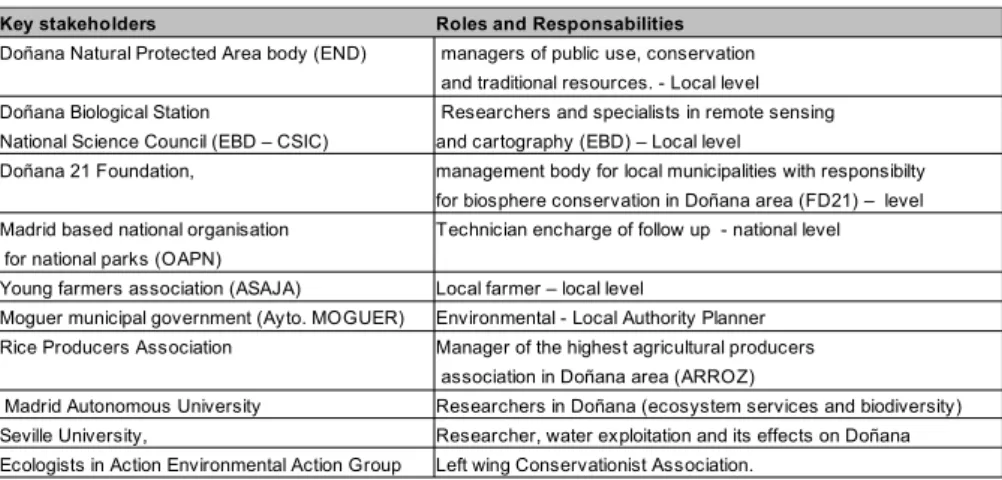
Table 1: Workshop participants and organisations Key stakeholders Roles and Responsabilities
Doñana Natural Protected Area body (END) managers of public use, conservation and traditional resources. - Local level Doñana Biological Station Researchers and specialists in remote sensing National Science Council (EBD – CSIC) and cartography (EBD) – Local level
Doñana 21 Foundation, management body for local municipalities with responsibilty for biosphere conservation in Doñana area (FD21) – level Madrid based national organisation Technician encharge of follow up - national level for national parks (OAPN)
Young farmers association (ASAJA) Local farmer – local level
Moguer municipal government (Ayto. MOGUER) Environmental - Local Authority Planner Rice Producers Association Manager of the highest agricultural producers
association in Doñana area (ARROZ)
These methods would combined well with modelling technologies which will be employed to assist with the development of baseline scenarios as tools to support decisions for policy makers, and planners. Several cycles of analysis would help to check out the qualitative information with our quantitative developments. In this way, we aim to achieve consensus, essential for the usefulness of the model as a decision support tool (Gómez Limon 2007).
3 RESULTS
2.1 Stakeholder mapping
In this section the steps carried out leading up to the participatory workshops are discussed. Initially, we began with a first phase of data acquisition, in which we addressed the difficulty finding the right “key stakeholders”, using the technique of stakeholder mapping to define stakeholder relations for the Doñana area. A stakeholder map is a graphical representation of social networks (conflict, consensus, broken relationships, etc.) and action groups (institutions, organizations, etc.) that characterize the problem domain in the territory at the current moment
(Villasante 2006). This analysis of internal and external
relationships allowed us to gain a complete picture of the social networks involved in the relevant issue, the dynamics of land use change in Doñana. The final rich picture (Figure 2) was established after several cycles of information and
understanding. Figure 2: Final Doñana stakeholder map
This initial phase was also fundamental in order to establish a successful flow of communication with other researchers working in Doñana, such as the members of the social-ecological systems laboratory at the Madrid Autonomous University (UAM) and participate in their workshops in Donana. In this way we able to learn from existing participatory processes in the same territory and take advantage of areas where information required by the UAM research group overlapped our own, such as in the establishment of the model study area. There was a wide group of participants with local people, ecologists, visitors, religious tourists etc. in which we could identify several key topics that persistently emerged among stakeholders (such as the importance of Doñana's surface water supply), as well as perceptions about future. Several workshops with experts in land use modelling (RIKS) were also carried out to draw on a wide range of experiences about the modelling process. The flows of communication between stakeholders observed during this first stage were very useful in order to progress to the next stage in which it was decided which stakeholders to invite and how best to organise the working groups, in every case stemming from the need to find consensus among them.
2.2 Identifying the right stakeholders to involve
participatory activities aimed at gathering information from stakeholders. Though it is always tempting to try to be as inclusive as possible, our workshops had very specific goals in mind; principally model parametrization. The decision as to which stakeholders to exclude was not an easy task, however, given that the parametrization workshop was dedicated to analysis of land change dynamics (and not management of the territory) and that space was limited, some interest groups whose knowledge was likely to be of marginal interest to the workshop, such as religious and cultural groups, could not be represented. Later workshops will offer the possibility to broaden the stakeholder community represented. In Doñana, we suffered from the simultaneous advantage and disadvantage of stakeholders to "self-select"; on the plus side this meant that workshop sessions were well-attended and populated by well-informed and motivated participants, a disadvantage to this was that it became more difficult to slim down the workshop sessions to obtain the numbers and specialisms required for the calibration and parametrization tasks specific to the model. Not all stakeholders approached through the project were immediately convinced of the value of the modelling approach proposed. Reservations on the part of these stakeholders varied from perceptions that the model generated was basically linear (the final outcome would essentially be determined by the starting condition), to the idea that the models somehow aimed to predict the future, a viewpoint probably common to all of those unfamiliar with simulation modelling (and perhaps simulation modellers are themselves to blame for this). There is no-doubt that excessive verbiage about "artificial intelligence" and "forecasting" has probably been unhelpful in this respect, though it should not be forgotten that many of today's modellers were attracted to the discipline through precisely this kind of terminology!
2.3 The Doñana study area
At a workshop with stakeholders organised by another research team (see above), it became clear, following an exercise aiming to define the appropriate biophysical limits of the Doñana area, that most stakeholders considered "Doñana" to be an area greatly in excess of the ENP. This valuable experience assisted us greatly with our eventual decision regarding the most appropriate study area, something non-trivial, and unfortunately too often determined arbitrarily without considering whether the study area chosen actually represents the dynamics that the model is aims to replicate. The study area eventually chosen was the hydrological catchment area of the Doñana marshes, an elongated triangular area which could reasonably be expected to include most land use dynamics that would directly influence the areas of natural importance.
2.4 Categories for the land use model
Land use data was obtained from the Junta de Andalucia environmental information network website (Moreira 2010) and comprised 1:25000 scale vegetation cover and land use maps 1956,1999, 2003, and 2007. In the study area defined above, 107 land use categories had been identified, clearly far too many to be incorporated into a land use model. Some reduction and reclassifications had to be made, but it was unclear to the researchers which categories should be retained in order to have the best possible chance of characterising Doñana for the land use model. After experimenting with a series of preliminary categorisations, we eventually reduced the 107 categories to 48. The parametrization workshop began therefore, with a land use classification exercise. To make the exercise more attractive, the 48 land use classes to be regrouped were presented in the form of a deck of cards bearing a number, land use description and photograph of the land use depicted. Figure 3 shows stakeholders involved in the land use classification exercise. Following this exercise, each group was asked to present their classification. In order to reduce disagreement and save time, researchers at this point drew on the three classifications to produce a consensus classification. This was then modified in open discussion with participants until a final set of
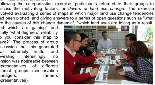
2.5 Land use dynamics
Following the categorization exercise, participants returned to their groups to discuss the motivating factors, or drivers of land use change. The exercise involved evaluating a series of maps in which major land use change tendencies had been plotted, and giving answers to a series of open questions such as "what are the causes of this change dynamic", "which land uses are losing as a result, and which are gaining" and
finally "what degree of reliability do you consider this map to have?" The process of group discussion that this generated was extremely fruitful and revealing. Interestingly, no tension was noticeable between representatives of different interest groups (conservation
managers, farmers
representatives).
Figure 3: land use classification exercise 2.6 Suitability
The final participatory exercise to form part of the model parametrization workshop was the determination of physical suitability criteria for the land use mode. While it is obvious that cereal crops do not grow on mountain tops and olive groves do not commonly occupy wetlands, more subtle environmental factors may play a part in the evolution of land cover, the details of which may be unknown to the researcher. For instance, what effect does precipitation have on the range of crops exploited and, simultaneously, how is the important natural superficial water supply to the Doñana marshland replenished? Local knowledge of these key environmental factors is clearly important for the development of suitability maps , one of the land use model's key inputs. Participants returned to their groups and , were asked, again on the basis of maps of each variable in the Doñana catchment, to evaluate the response of the each of the consensus land use categories to a series of environmental variables, such as soils, rainfall, slope and temperature. Though responses were highly qualitative and somewhat general, many excellent points were made that allow informed choices to be made concerning the influence of each environmental variable on the selected model categories.
3 CONCLUSIONS
opportunity to reinforce the importance to planning decision support of those areas where there is common agreement. It is too early to respond to the question of reconciliation between environment and development, however, these, and other ongoing participatory initiatives suggest that there are reasons to be optimistic about the future. The work discussed here is ongoing and, in subsequent phases, stakeholders will be engaged for model calibration, model evaluation, scenario building in order to move towards the common goal of a shared Doñana, in which all interest groups are mutually engaged to bring about the social and environmental transformation of the territory towards a more sustainable configuration.
ACKNOWLEDGMENTS
The authors would like to thank to the OAPN who funded this project. We are also very grateful to all members of the social-ecological systems laboratory, UAM, for their indispensable assistance in establishing our participatory process, and to Hedwig Van Delden of RIKS B.V., who made helpful suggestions on ways to improve our workshops sessions. Our gratitude is also due to our tireless workshop participants who gave up their time and knowledge for the advancement of the study of Doñana. We are also grateful to an anonymous reviewer for their comments that led to improvements to this paper.
REFERENCES
Batty, M., Xie, Y., & Sun, Z. Modeling urban dynamics through GIS-based cellular automata. Computers, Environment and Urban Systems, 23, 205–233, 1999 Brundtland, G.H. Our common future. UN Documents. United Nations Convention for Environment and Development,1987.
Chambers, R. Rural appraisal: rapid, real and participatory, Brighton, IDS . 1992 Evaluación de los Ecosistemas del Milenio de España (EME). La Evaluación de
los Ecosistemas del Milenio de España. Fundación Biodiversidad. Ministerio de
Medio Ambiente, y Medio Rural y Marino, 2011
Forrester, J.W., Industrial Dynamics. MIT Press, Cambridge, MA. Reprinted by Pegasus Communications, 1961
Gómez Limón, J. Enredando. Herramientas para la comunicación y participación
social en la gestión de la Red de Parques Nacionales. Europarc-España, 2007
Healey, P. Collaborative planning: shaping places in fragmented societies.
Planning, Environment and Cities, London. Palgrave McMillan, 1997
Hernandez-Jimenez, V. Participatory planning in the region of Madrid: an integrative perspective. Thesis, Newcastle University, 2007
Martín-López, B.,García-LLorente, M., Palomo, I. and C. Montes. The conservation against development paradigm in protected areas-. Valuation of ecosystem services in the Doñana social-ecological system (SW Spain).
Ecological Economics 70:148, 2011
Montes, C. Construir Resiliencia para Doñana en un mundo cambiante. Revista Sostenible 35:14-15, 2007.
Montes, C, Gómez , E., Lomas, P. , Martín, B., Sastre, S., and Zorrilla, P. Hacia una visión compartida del desarrollo sosteinible en Doñana. II Plan de Desarrollo
Sostenible de Doñana. WWF and Junta de Andalucia, 2010.
Moreira,J. Digital map data at 1:25000 scale, Junta de Andalucía - Environmental
information network website; accessed September 2011
Moreno, N., Quintero, R., Ablan, M., Barros, R., Dávila, J., Ramírez, H., Tonella, G., et al. Biocomplexity of deforestation in the Caparo tropical forest reserve in Venezuela: An integrated multi-agent and cellular automata model. Environmental Modelling & Software, 22(5), 664–673, 2007
Palomo, I., Martín-López, B. , López-Santiago C. and C. Montes. Participatory Scenario Planning for Natural Protected Areas management under ecosystem services framework: the Doñana social-ecological system, SW, Spain.
Ecology&Society, 16:23, 2011
Villasante, T., Montañes M. and J. Martí (eds.) La investigación social
participativa: construyendo ciudadanía, Cataluña, El Viejo Topo, 2000
Voinov,A. and F. Bousquet. Environmental Modelling & Software 25: 1268, 2010. Winder, N. Innovation and Metastability: a systems model. Ecology and Society
12 (2).2007
White, R., & Engelen, G. Cellular automata and fractal urban form: a cellular modelling approach to the evolution of urban land-use patterns. Environment and
Planning A, 25(8), 1175–1199, 1993
Wagner, T.P., Ortolando, L., 1976. Testing an Iterative, Open Process for Water Resources Planning. U.S. Army Engineer Institute for Water Resources, Fort Belvoir, Va., 66 pp. (IWR contract report no. 76-2).