The Vale de Santarém Neogene trough in the
seismotectonics framework of the Lower Tagus Valley
(Portugal)
D. D’AMATO
1*, B. PACE
1, J. CABRAL
2ANDP. M. FIGUEIREDO
21GeoSisLab, Facoltà di Scienze Matematiche, Fisiche e Naturali UdA Chieti, via dei Vestini 31, Chieti Scalo, Italy.
2University of Lisbon, LATTEX, IDL, Ed. C6, Campo Grande, 1749–016 Lisboa, Portugal.
*e-mail: dd.damato@gmail.com
Abstract: Vale de Santarém is a small valley near the Tagus River, 60 km NNE of Lisbon, in an area of important seismicity. It is located in the Lower Tagus Cenozoic Basin, astride a narrow WNW-ESE tec-tonic trough where a thick Pliocene sedimentary sequence is preserved. Tectec-tonic control is evidenced by faults bordering the trough, which have controlled sedimentation. It is aligned with the Rio Maior Pliocene basin, located 20 km NW, suggesting a WNW-ESE fault zone beneath the Neogene sedimen-tary cover, which was reactivated in Plio-Pleistocene (?) times, generating the small tectonic basins at the southern and northern tips. The interference of this structure with the active NNE-SSW faults of the Tagus Valley may cause segmentation of these faults, with implications for the expected seismogenic sources and the regional seismic hazard.
Keywords: Vale de Santarém, tectonic basin, seismotectonics, Lower Tagus Valley, Portugal.
The study area is located on the western Portuguese mainland and involves the highly developed and populated region of Lisbon. It is located a few hun-dred kilometres north of the Eurasian (Iberia)-Africa plate boundary (the Azores-Gibraltar frac-ture zone), in the Lower Tagus River Valley (LTV) (Carvalho et al., 2006). This valley is located in the Lower Tagus Cenozoic Basin (LTCB), a NE-SW trending trough filled with up to about 2 km of sediments of Cenozoic age, which resulted from tectonic inversion of the Mesozoic Lusitanian Basin, located to the west, predominantly under the action of a Miocene compression (Fig. 1a).
The study region is presently characterized by the occurrence of a low, diffuse seismicity, though it has been affected by a few historical earthquakes that
caused many casualties, serious damage and econom-ic losses. Besides the action of large earthquakes gen-erated in the southwestern offshore area, such as the one on November, 1st 1755, one of the largest earth-quakes ever recorded (estimated magnitude ≥8.5, Martins and Mendes-Víctor, 1990; Zitellini et al., 1999; Baptista et al., 2003; Gràcia et al., 2003), con-nected with the seismicity of the Iberia–Africa plate boundary, the study region records significant intraplate activity, witnessing important historical and instrumental earthquakes that periodically affect this area, such as the events in 1344, 1531 and 1909, with assigned magnitudes of 6 to 7 (Martins and Mendes-Víctor, 1990; Cabral et al., 2003).
F
igur
e 1.
(a) G
eological M
ap of the Lo
w er T agus V alley R
egion, adapted fr
om “Car
ta G
eológica de P
or
tugal
”, 1: 500 000 scale (O
liv
eira
et al.
, 1992). K
ey – 1: P
aleoz
oic basement; 2 and
3: J
u
rassic and C
retaceous sediments of the L
usitanian B
asin, r
espectiv
ely; 4: S
intra Late-C
re
taceous intr
usiv
e massif; 5, 6 an
d 7: P
aleogene, M
iocene and P
liocene sediments of the Lo
w
er
T
agus basin, r
espectiv
ely; 8 and 9: P
leistocene and H
olocene fluvial sediments of the
T
agus riv
er
, r
espectiv
ely; 10: mapped fau
lt (adapted fr
om Cabral
et al.
, 2003, 2004; Car
valho
et al.
,
2006), (b) epicentr
e distribution of instr
u
mental seismicity in the Lo
w er T agus V alley R
egion and adjacent ar
eas for the period
1915 to 2004, fr
om the I
nternational S eismological Centr e, on-line B u lletin,http://www .isc.ac.uk/ bu ll, I nt er na tio na l S ei sm ological Center
, Thatcham, U
n
it
ed
K
in
gdom, 2001. S
ymbol dimension is pr
opor
tional to magnitude: 1: M2; 2: 2<M3; 3: M>3
(<4). S
eismic intensities (I MM) and isoseismal lines for the ear
thquakes in 1531 (dashed lines, adapted fr
om O
liv
eira and S
ous
a, 1991) and 1909 (dotted lines, intensity in italics,
adapt-ed fr
om M
or
eira, 1984). F
ocal mechanism fr
om Borges
et al.
having been positioned in the LTV based upon the destruction that they produced in the Lisbon area. The most recent major earthquake, whose epicentre was located NE of Lisbon near the village of Benavente occurred on April 23rd 1909. In this area the shock was registered with the maximum intensity of IX (MM) (Bensaúde, 1910; Choffat and Bensaúde, 1911; Choffat and Bensaúde, 1912; Moreira, 1984; Oliveira, 1986). Teves-Costa et al.(1999) calculated a moment magnitude of 6.0 for this earthquake, based upon analogue seismograms recorded in the Strasbourg and Uppsala seismic stations, and Stich et al.(2005) calculated a focal mechanism for the event, obtaining a reverse fault solution with nodal planes oriented 051°, 52° SE and 242°, 38° NW. The focal mechanism thus suggests an ENE-WSW trending source fault in the LTV fault system. The doubtful epicentre location and the interference of site effects and possible rupture directivity make it difficult to correlate this event with any known regional tectonic structure.
The occurrence of earthquakes indicates seismogenic faults in the study region that are still poorly con-strained, due to the low slip-rates and the presence of a thick Holocene sedimentary cover that conceals many of the structures in the underlying Mesozoic and Paleozoic basement. Moreover, the available data regarding hypocentre depths (mostly between 10 and 20 km) show that the seismicity in the LTV is devel-oped in the upper crust and is mostly generated by structures present in the Paleozoic basement under the Cenozoic and Mesozoic basins, which thus rup-ture several kilometres below the Cenozoic sedimen-tary cover.
Regional structural setting
The LTCB is undoubtedly a sedimentary sink intensely affected by tectonics, which acted mainly from the Neogene to the Quaternary, whose evolu-tion was controlled by the NNE-SSW structural trend of the Lusitanian Basin. NW dipping pre-exis-tent normal faults of Mesozoic age were affected by tectonic inversion in the Cenozoic and moved as oblique slip reverse faults that transferred Mesozoic rocks of the Lusitanian Basin to the NW over Cenozoic sediments of the LTCB to the SE (Cabral et al., 2003; Carvalho et al., 2006) (Fig. 1a).
The Vila Franca de Xira and Azambuja faults are two important structures with this trend that have been recognized in the LTV (Fig. 1a). The first outcrops on the right bank of the Tagus River about 25 km north
of Lisbon, and shows the best morphological expres-sion in the LTV as an east facing fault scarp. It con-sists of a NNE-SSW oriented complex fracture zone recognized by geological outcropping and from deep seismic reflection data and aeromagnetic data inter-pretation (Carvalho et al., 2006). It is partially hidden under recent alluvium of the Tagus River and is inter-sected by a transverse NW-SE fault system, being off-setthrough a left-lateral step-over.
The Azambuja fault, located about 15 km further NE, is another regional NNE-SSW trending struc-ture showing geomorphologic and structural evidence of Pliocene to Quaternary activity (Cabral et al., 2004). It presents a 15 km long fault scarp, down-throwing to the east a Lower Pleistocene erosion sur-face. Near the village of Azambuja, where the fault crosses the Tagus River bank, the vertical offset has a maximum value of around 80 m decreasing progres-sively northwards.
Besides the presence of major NNE-SSW “longitudi-nal” faults, there is geological evidence, as well as gravimetric and deep seismic reflection data, evidenc-ing the presence of a system of WESE to NW-SE trending “transverse” faults that have made appar-ently a significant contribution to the overall struc-ture of the LTCB and must be considered in the eval-uation of the regional seismogenic potential (Carvalho, 2003; Cabral et al., 2003; Carvalho et al., 2006).
The Vale de Santarém structures
In this study we focused attention on the most conspic-uous outcropping example of the “transverse” fault sys-tem in the LTV, which is the Vale de Santarém tectonic basin (Fig. 2). The area of Vale de Santarém had never previously been studied in detail and the aim of this work is to provide a better understanding of the possible behaviour of the “transverse” structures in the case of activity of the main, NNE-SSW trending faults.
F
igur
e 2.
(a) G
eological M
ap of the Lo
w
er
T
agus
V
alley R
egion, adapted fr
om “Car
ta G
eológica de P
or
tugal
”, 1: 500 000. F
rame: studied ar
ea detailed in figur
e 2b
, (b) geological map
of
V
ale de S
antar
Pliocene, partially controlling the sedimentation, which shows particular facies evidencing a continental confined environment.
The Pliocene deposits preserved in the Vale de Santarém tectonic trough, as well as other fluvial deposits of similar age located outside this basin, mainly to the south, unconformably overlie sediments of Valesian age (Upper Miocene). These are fluvial and lacustrine continental deposits showing a variety of facies, including predominantly white, yellow or red sands and variably consolidated arkosic sand-stones, some pebbly horizons, silty and clayey layers, as well as limestone and marls with caliches.
The Pliocene sediments outcropping inside the small tectonic basin show two distinct facies, one consist-ing of well sorted, medium to fine grained red sands with oblique laminations, often consolidated, show-ing some white areas due to near surface leachshow-ing of iron oxides, and another consisting of medium to coarse grained, consolidated, arkosic red sands with quartz pebbles; a brown coal layer was observed
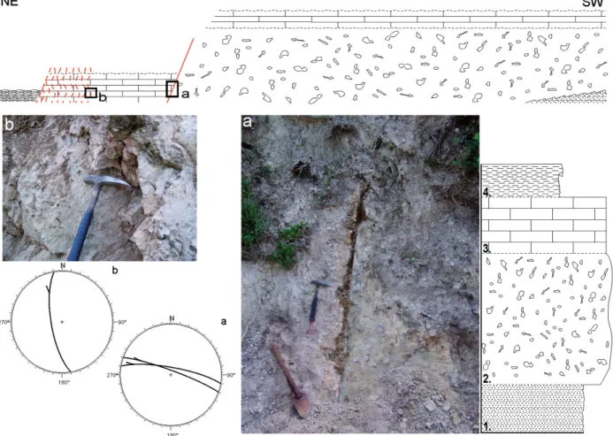
underlying fine sands on the northern side of the val-ley. Fifteen boreholes have been drilled in the Pliocene infill of the Vale de Santarém trough for lig-nite prospecting, with an average depth of 45 m and a maximum of 110 m (Pais et al., 1999). The bore-holes have cut through whitish quartz sands with interbedded thin clay layers rich in organic matter, and layers of lignite and diatomite, showing a maxi-mum thickness of about 70 m. South of the southern fault that borders the tectonic trough, the Pliocene basal unconformity rises to an elevation of about 50 m, showing a syn- to post-Pliocene vertical throw of several tens of meters in this fault.
The Vale de Santarém Pliocene basin is an asymmet-ric, southwestwards tilted, tectonic trough, generated by two subvertical NW-SE/WNW-ESE trending faults approximately 0.75-1 km apart, the southern one being the major structure. On the north side of the valley a faulted contact was observed between Miocene sandstones and Pliocene clays and sands, locally featuring normal (fault dip: 230/78) or reverse (fault dip: 040/70) fault movement component. On
References
BAPTISTA, M. A., MIRANDA, J. M., CHIERICI, F. and ZITELLINI, N. (2003): New study of the 1755 earthquake source based on multi-channel seismic survey data and tsunami modelling. Nat. Hazards and Earth Syst. Sci., 3: 333-340.
BENSAÚDE, A. (1910): Le tremblement de terre de la vallée du
Tage du 23 avril 1909. (Note préliminaire). B. Soc. Port. Sci. Nat., 3: 89-129.
BORGES, J. F., FITAS, A. J. S., BEZZEGHOUD, M. and TEVES -COSTA, P. (2001): Seismotectonics of Portugal and its adjacent
Atlantic area, Tectonophysics, 337: 373-387.
CABRAL, J., MONIZ, C., RIBEIRO, P., TERRINHA, P. and MATIAS, L. (2003): Analysis of seismic reflection data as a tool for the seismo-tectonic assessment of a low activity intraplate basin – the Lower Tagus Valley (Portugal).J. Seismol, 7, 4: 431-437.
CABRAL, J., RIBEIRO, P., FIGUEIREDO, P., PIMENTEL, N. and
MARTINS, A. (2004): The Azambuja fault: An active structure located in an intraplate basin with significant seismicity (Lower Tagus Valley, Portugal). J. Seismol., 8: 347-362.
CARVALHO, J. (2003): Sísmica de alta resolução aplicada à porspec-çao, geotecnia e risco sísmico. PhD Thesis, University of Lisbon. CARVALHO, J., CABRAL, J., GONÇALVES, R., TORRES, L. and MENDES-VICTOR, L. (2006): Geophysical methods applied to fault characterization and earthquake potential assessment in the Lower Tagus Valley, Portugal. Tectonophysics, 418, 3-4: 277-297. CHOFFAT, P. and BENSAÚDE, A. (1911): Études Sur le Séisme du
Ribatejo du 23 Avril du 1909. Comissão do Serv. Geol. Port., Imprensa Nacional, Lisbon.
CHOFFAT, P. and BENSAÚDE, A. (1912): Estudios sobre o sismo du Ribatejo du 23 Avril du 1909, Comissão do Serv. Geol. Port., Imprensa Nacional, Lisbon.
GRÀCIA, E., DAÑOBEITIA, J., VERGÉS, J and THEPARSIFAL TEAM
(2003): Mapping active faults offshore Portugal (36°N–38°N):
implications for seismic hazard assessment along the southwest Iberian margin. Geology, 31: 83-86.
MARTINS, I. and MENDES-VÍCTOR, L. A. (1990): Contribuição para o Estudo da Sismicidade de Portugal Continental. Instituto Geofísico Infante D. Luís, 18.
MOREIRA, V. S. (1984): Sismicidade histórica de Portugal
Continental. Rev. Inst. Nac. Met. e Geofísica, (Março 1984): 3-79. OLIVEIRA, C. S. (1986): A Sismicidade Histórica e a Revisão do Catálogo Sísmico. Proc. 36/11/7368, I e D, Estruturas, Relatório 99/86 – NDA, LNEC, Lisbon, 192.
OLIVEIRA, C. S., (1992): Carta Geológica de Portugal, 1:500 000.
Serviços Geológicos de Portugal.
OLIVEIRA, C. S. and SOUSA, A. (1991): A contribution to reduce subjectivity in treatment of historical data. In: J. MEZCUAand A,
UDÍAS (eds): Seismicity, Seismotectonics and Seismic Risk of the Ibero-Maghrebian Region, Publication I.G.N. Série Monografia vol. 8, Instituto Geografico Nacional (1991): 97-114.
PAIS, J., PAIS, C., PEREIRA, V. and BARBOSA, B. (1999): Areias de Vale de Santarém. Estratigrafia e Palinologia. Cièncias da Terra
(UNL), 13: 23-34.
STICH, D., BATLLÓ, J., MACIÁ, R., TEVES-COSTA, P. and MORALES, J.
(2005): Moment tensor inversion with single-component historical seismograms: The 1909 Benavente (Portugal) and Lambesc (France) earthquakes. Geophys. J. Int., 162: 850-858.
TEVES-COSTA, P., BORGES, J. F., RIO, I., RIBEIRO, R. and
MARREIROS, C. (1999): Source Parameters of Old Earthquakes:
Semi-Automatic Digitization of Analog Records and Seismic Moment Assessment. Nat. Hazards, 19, 2-3: 205-220.
ZITELLINI, N., CHIERICI, F., SARTORI, R., and TORELLI, R. (1999):
The tectonic source of the 1755 Lisbon earthquake and tsunami.
Ann. Geofis., 42: 49-55.
the SW side, the major boundary fault outcrops in a railway cutting, well expressed in the Miocene sedi-ments as ca. 15 m of intense fracturing and breccia-tion (Fig. 3). Some (dubious) striabreccia-tions observed in a faulted contact between limestone and a gravelly layer suggests an oblique left-lateral transtensive regime. Further NW, this structure was observed affecting the overlying Pliocene sediments (dip: 040/70, dip: 060/70).
The Vale de Santarém structure is aligned with anoth-er Pliocene tectonic trough located about 20 km to the NW, the Rio Maior basin (Figs. 1 and 2). This suggests the presence a continuous, WNW-ESE trending fault zone beneath the Neogene sedimentary cover of the LTCB which was reactivated, mainly near
its extremities, in Plio-Pleistocene times, with scissor-like displacement, downthrowing to the NE, at the southern tip, where it interferes with the “longitudi-nal” fault system of the LTV, and downthrowing to the SW at Rio Maior, where it interferes with anoth-er major NNE-SSW trending structure, the Porto de Mós-Rio Maior fault zone.