© The authors and ICE Publishing: All rights reserved, 2015 doi:10.1680/ecsmge.60678
4 CONCLUSIONS
1. This paper has examined why the karst geohaz-ards that caused significant delay (> 1 year) and additional costs for the development of the Carsington Pasture Wind Farm were unfore-seen. It is concluded that this was primarily be-cause there were no published analogues for the karst encountered at Carsington Pasture.
2. The findings, which have implications for ground investigations in similar terrains, have confirmed the difficulty of engineering in deep-ly karstified ground, particulardeep-ly at the platform edge where there is a greater propensity for faulting and jointing. This setting is commonly the focus for dolomitization and other MVT fluids.
3. The value of geological process understanding in reading the ground for engineering purposes and developing good conceptual ground models (working documents that should be updated as the investigation and proceeds) has been demonstrated.
4. The benefit that integrated geophysical surveys can bring to the investigation of karst terrains has been described.
5. Retention of the site investigation core will fa-cilitate further research into the nature of both the expulsion fluids penetrating the platform edge and the overlying sediments.
ACKNOWLEDGEMENTS
Carsington Wind Energy Limited and West Coast Energy Limited (GDF Suez) are thanked for permis-sion to access the exposures during the construction period. We are particularly grateful to Roger Durrant (Raymond Brown Limited) for facilitating access and the provision of some of the records. Waltham is thanked for provision of Figure 4. Banks and Raines publish with the permission of the executive director of the British Geological Survey.
REFERENCES
Appelo, C.A.J. & Postma, D. 2005. Geochemistry, groundwater and pollu-tion, 2nd edition. A.A. Balkema Publishers. Leiden/London/New
York/Philadelphia/Singapore.
Casagrande, G., Cucchi, F., and Zini, L. 2005. Hazard connected to railway tunnel construction in karstic areas: applied geomorphological and hydroge-ological surveys, Natural Hazards and Earth Systems Sciences 5, 243–250. Cornwell, J.D. and Walker, A.S.D. 1989. Regional Geophysics. In: Plant, J.A and Jones, D.G., (Editors). 1989. Metallogenic models and exploration criteria for buried carbonate-hosted ore deposits – a multidisciplinary study in eastern England. London: The Institution of Mining and Metallurgy, Keyworth, Nottinghamshire: British Geological Survey, 25 - 51.
Castellaro, S., F. Mulargia, and L. Bianconi (2005). Passive seismic stratig-raphy: a new efficient, fast and economic technique, J. Geotech. Environ. Geol.3, 51–77.
DTLR (Department for Transport, Local Government and the Regions) 2002.Planning Policy Guidance Note 14 Development on unstable land. Annex 2: Subsidence and Planning. HMSO, Norwich.
Fookes, P.G., Baynes, F.J. & Hutchinson, J.N. 2001. Total geological histo-ry: a model approach to understanding site conditions. Technical Note. Ground Engineering,34, 42–47.
Ford, T.D. 1989. Palaeokarsts in Britain, Transactions of the British Cave Research Association,11, No.4, 246–264.
Ford, A.N. & Gunn, A.N. 2007. Hydrogeology of the Brassington area, Derbyshire, UK. Cave and Karst Science34, No.1,17-22.
Herman, J.S. & White, W.B. 1985. Dissolution kinetics of dolomite: Effects of lithology and fluid flow velocity. Geochimica et Cosmochimica Acta,49, 2017-2026.
Hollis, C. and Walkden, G. 2002. Reconstructing fluid expulsion and migra-tion north of the Variscan orogen, Northern England. Journal of Sedimen-tary Research, 72, 5, 700-710.
Jones, P.F. & Banks, V.J. 2014. Generating new geo-data,Geoscientist24, No.8, 12–17.
Rieuwerts, J.H. 2012., Lead mining in Derbyshire: history, development and drainage. 4. The area south of the Via Gellia. Landmark Publishing. Ash-bourne, Derbyshire.
Rowberry,M.D., Batteau-Queney, Y., Walsh, P.T.Błażejowski, B., Bout -Roumazeilles, V., Trentesaux, A., Křížová, L & Griffiths, H.2014. The weathered Carboniferous limestone at Bullslaughter Bay, South Wales: the first example of ghost-rock recorded in the British Isles, Geologica Belgica 17, No.1 33–42.
Skempton, A. W. & Vaughan, P.R. 1993. The failure of Carsington Dam, Géotechnique,43, No.1, 151–173.
Walsh, P.T., Boulter, M.C., Ijtaba, M. and Urbani, D.M. 1972. The preser-vation of the Neogene Brassington Formation of the southern Pennines and its bearing on the evolution of the British Isles. J. Geol. Soc. London. 128, 519-559.
Waltham, A. C. 2012. Chapter 38. Soluble Ground. In: ICE Manual of Ge-otechnical Engineering (Eds: Burland, J., Chapman, T., Skinner, H. and Brown, M.), 533-545. ICE Publishing, London.
Waltham, A.C. & Fookes P. 2003. Engineering classification of karst ground conditions.Quarterly Journal of Engineering Geology and Hydro-geology,36, 101-118.
Waltham, A. C., Bell, F.G. and Culshaw, M.G. 2004.Sinkholes and cavern-ous rocks in engineering construction. Springer, in association with Praxis Publishing, Chichester, UK.
Willies, L. 1995. Roads, agricultural features and mines on Carsington Pas-ture. Bulletin of the Peak District Mines Historical Society,12, No. 5, 19-23. Yean-Chin, T. and Chee-Meng, C. 2014. Foundation design and construc-tion in limestone formaconstruc-tion: a Malaysian Consultant’s experience. In: Pro-ceedings of the International Advances in Foundation Engineering (Eds: Phoon, K.K., Chua, T.S., Yang, H.B. and Cham, W.M.).
Interaction between infrastructures and karst. Protekarst
analysis method
L'interaction entre les infrastructures et le karst. La méthode d'analyse
Protekarst
F. Carrasco*1, P. Jiménez1, J.M. Thode2, M.I. Fiestas2 and R. Fernández3
1
University of Málaga, Málaga, Spain 2
Agencia de Obra Pública de la Junta de Andalucía, Sevilla, Spain 3
Intecsa-Inarsa, S.A., Madrid, Spain *
Corresponding Author
ABSTRACT This paper presents the Protekarst method, by which karst protection zones can be mapped after quantifying their main geo-logical, botanical, zoogeo-logical, scenic, archaeogeo-logical, hydrogeogeo-logical, economic and social characteristics. The method was applied to a sierra in southern Spain. We describe the contribution made by the method to the design of new road infrastructure, and show that it enables us to compare alternative routes, to evaluate the impact made on karst values by previous road construction and to select suitable routes for paths or trails that pass through karst areas of special interest.
RÉSUMÉ Cet article présente la méthode Protekarst, par lequel les zones de protection karstiques peuvent être cartographiées après avoir quantifié leurs principales caractéristiques géologiques, botaniques, archéologiques, hydrogéologiques, économiques et sociaux, et leurs faune et paysage. La méthode a été appliquée à un massif dans le sud de l'Espagne. Nous décrivons la contribution apportée par cette mé-thode au développement de nouvelles infrastructures routières, ce qui permet la comparaison d'itinéraires alternatifs, l'évaluation des im-pacts occasionnés sur les valeurs karstiques par les routes construites auparavant et la possibilité de tracer des parcours appropriés pour les chemins ou sentiers qui passent à travers des zones karstiques d'intérêt particulier.
1 INTRODUCTION
The term karst is applied to certain geological
for-mations in which the pores and fractures in rocks are
widened by the action of water, creating conduits,
caves and a characteristic landscape, both superficial
(exokarst) and underground (endokarst). There are
two major groups of karstifiable rocks: evaporites
(gypsum and salt) and carbonate rocks (limestones,
dolomites and marbles).
Karst is a significant part of our natural and
cul-tural heritage, presenting important scientific value
(biological, geological, hydrological,
hydrogeologi-cal and archaeologihydrogeologi-cal), cultural value (the remains
and artefacts of our ancestors, cave paintings and
scenic values) and socio-economic value (agriculture,
forestry, mining, extraction from quarries, tourism
and various uses of stored water).
The activities carried out in and around karst
sub-ject it to various pressures that can have adverse
ef-fects. For example, quarrying, road construction or
the dumping of inert waste and other materials can
produce the destruction of external karst forms or of
cavities, as well as irreversibly altering natural cycles
and flows. Similarly, forest fires and agriculture can
cause changes in nutrient flows between the soil and
the endokarst. Furthermore, the introduction of
con-taminants into the karst system provokes changes in
groundwater quality.
The protection of karst forms part of the global
de-fence of the conservation of geodiversity,
biodiversi-ty and, in general, of our heritage in its broadest
sense. Therefore, a methodological framework is
de-fined and karst systems in general safeguarded. Such
a framework is provided by the Protekarst method.
In Andalusia (southern Spain), large areas are
characterised by the presence of limestone mountain
ranges, which are spectacularly rugged in places and
not only contribute to the beauty of the landscape but
also present other values that are very important to
preserve when the construction of new transport
in-frastructure is considered. For example,
geomorpho-logical values include such emblematic sites as the
exokarstic forms of Torcal de Antequera and various
enclaves within the Serrania de Ronda, between the
provinces of Málaga and Cádiz, as well as unique
cave systems such as those of Nerja and
Hundidero-Gato and the sinkholes in Sierra de las Nieves and
Sierra de Líbar. Furthermore, the botanical and
zoo-logical values in this region are of major importance
in some areas, with plants that only flourish in
asso-ciation with certain carbonate geological formations.
Finally, there are various cavities that contain
ar-chaeological remains, as well as important
popula-tions of bats and other cave fauna.
But, above all, it is the hydrogeological values, the
fundamental role played by karst aquifers in response
to water demands, and the need to maintain water
flow in river system which most strongly emphasise
the need to take precautions to ensure that future
lin-ear infrastructure projects have no adverse effect on
water quality or aquifer functioning. The experience
of recent projects such as the high-speed rail tunnels
through the Valle de Abdalajís mountain (province of
Málaga), which have provoked a drastic fall in water
reserves and a probably irreversible change in
drain-age points and in directions of groundwater flow,
highlight the need for the utmost precaution to be
taken, and to acquire sufficient understanding of the
terrain before embarking on new infrastructure
pro-jects that may impact on karst values.
2 METHODOLOGY
The Protekarst method that we propose is based on
the generation of thematic maps of characteristic
val-ues of karst. When these are integrated, it will enable
us to create a protection map classifying different
ar-eas in terms of their protection requirements, from
“very low-grade protection” to “very high-grade
pro-tection”. The method consists of the following steps
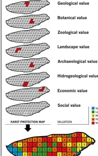
(Figure 1):
a) Define karst values. The following karst value
areas were selected: geology, flora, fauna, landscape,
archaeology and hydrogeology, together with
eco-nomic and social values.
Figure 1. Summary of the Protekarst method.
b) Quantify the different values. A specific, different
methodology is proposed for each of the values
se-lected, such that, for each karstic massif, eight
georeferenced thematic layers will be obtained,
showing the zonal distribution of each value, scored
from 0 to 5, from lowest to highest importance in
terms of protection. The complete methodology for
quantifying each value can be consulted at Junta de
Andalucía-Universidad de Málaga (2014), Project
G-GI3000/IDIM. For example, the geological value is
obtained from three variables: geological heritage,
geodiversity and karst geomorphology.
c) Obtain the karst protection map. The karst
pro-tection map is obtained from the superposition of the
above-described thematic layers, using a GIS. This
process generates a map in which each cell or pixel is
associated with a corresponding valuation index,
consisting of the eight cell values for each layer
over-lay (Figure 1). This information is then used to derive
the karst protection map, differentiating the required
degree of protection from lowest (1) to highest (5).
The protection is then quantified as follows:
1) If a pixel has at least one value of 5, it is
as-signed a value of 5 on the protection map.
2) If a pixel has at least two values of 4, it is
as-signed a value of 4 on the protection map.
3) If a pixel has at least three values of 3 or two
values of 3 and one of 4, it is assigned a value of 3 on
the protection map.
4) If these conditions are not met, the mean value
of the pixels is calculated. The result will be between
1 and 2.5:
Pixels with values from 1.5 to 2.5 are assigned
a value of 2 on the protection map.
Pixels with values of less than 1.5 are assigned
a value of 1 on the protection map.
3 RESULTS. APPLICATION OF THE METHOD
TO SIERRA DE MIJAS
Sierra de Mijas (Figure 2) lies in the southern part of
the province of Málaga, in southern Spain. It has an
area of about 90 km2 and it is composed almost
en-tirely of Triassic limestone and dolomitic marbles
corresponding to the Alpujárride Complex within the
Internal Zone of the Betic Cordillera.
fined and karst systems in general safeguarded. Such
a framework is provided by the Protekarst method.
In Andalusia (southern Spain), large areas are
characterised by the presence of limestone mountain
ranges, which are spectacularly rugged in places and
not only contribute to the beauty of the landscape but
also present other values that are very important to
preserve when the construction of new transport
in-frastructure is considered. For example,
geomorpho-logical values include such emblematic sites as the
exokarstic forms of Torcal de Antequera and various
enclaves within the Serrania de Ronda, between the
provinces of Málaga and Cádiz, as well as unique
cave systems such as those of Nerja and
Hundidero-Gato and the sinkholes in Sierra de las Nieves and
Sierra de Líbar. Furthermore, the botanical and
zoo-logical values in this region are of major importance
in some areas, with plants that only flourish in
asso-ciation with certain carbonate geological formations.
Finally, there are various cavities that contain
ar-chaeological remains, as well as important
popula-tions of bats and other cave fauna.
But, above all, it is the hydrogeological values, the
fundamental role played by karst aquifers in response
to water demands, and the need to maintain water
flow in river system which most strongly emphasise
the need to take precautions to ensure that future
lin-ear infrastructure projects have no adverse effect on
water quality or aquifer functioning. The experience
of recent projects such as the high-speed rail tunnels
through the Valle de Abdalajís mountain (province of
Málaga), which have provoked a drastic fall in water
reserves and a probably irreversible change in
drain-age points and in directions of groundwater flow,
highlight the need for the utmost precaution to be
taken, and to acquire sufficient understanding of the
terrain before embarking on new infrastructure
pro-jects that may impact on karst values.
2 METHODOLOGY
The Protekarst method that we propose is based on
the generation of thematic maps of characteristic
val-ues of karst. When these are integrated, it will enable
us to create a protection map classifying different
ar-eas in terms of their protection requirements, from
“very low-grade protection” to “very high-grade
pro-tection”. The method consists of the following steps
(Figure 1):
a) Define karst values. The following karst value
areas were selected: geology, flora, fauna, landscape,
archaeology and hydrogeology, together with
eco-nomic and social values.
Figure 1. Summary of the Protekarst method.
b) Quantify the different values. A specific, different
methodology is proposed for each of the values
se-lected, such that, for each karstic massif, eight
georeferenced thematic layers will be obtained,
showing the zonal distribution of each value, scored
from 0 to 5, from lowest to highest importance in
terms of protection. The complete methodology for
quantifying each value can be consulted at Junta de
Andalucía-Universidad de Málaga (2014), Project
G-GI3000/IDIM. For example, the geological value is
obtained from three variables: geological heritage,
geodiversity and karst geomorphology.
c) Obtain the karst protection map. The karst
pro-tection map is obtained from the superposition of the
above-described thematic layers, using a GIS. This
process generates a map in which each cell or pixel is
associated with a corresponding valuation index,
consisting of the eight cell values for each layer
over-lay (Figure 1). This information is then used to derive
the karst protection map, differentiating the required
degree of protection from lowest (1) to highest (5).
The protection is then quantified as follows:
1) If a pixel has at least one value of 5, it is
as-signed a value of 5 on the protection map.
2) If a pixel has at least two values of 4, it is
as-signed a value of 4 on the protection map.
3) If a pixel has at least three values of 3 or two
values of 3 and one of 4, it is assigned a value of 3 on
the protection map.
4) If these conditions are not met, the mean value
of the pixels is calculated. The result will be between
1 and 2.5:
Pixels with values from 1.5 to 2.5 are assigned
a value of 2 on the protection map.
Pixels with values of less than 1.5 are assigned
a value of 1 on the protection map.
3 RESULTS. APPLICATION OF THE METHOD
TO SIERRA DE MIJAS
Sierra de Mijas (Figure 2) lies in the southern part of
the province of Málaga, in southern Spain. It has an
area of about 90 km2 and it is composed almost
en-tirely of Triassic limestone and dolomitic marbles
corresponding to the Alpujárride Complex within the
Internal Zone of the Betic Cordillera.
Areas of very high protection (level 5) represent
26% of the surface area of the sierra and correspond,
in general, to areas with very high scores for
botani-cal and scenic parameters (Figure 2). In addition,
there are some small areas with the same protection
value on the northern edge of the sierra, which
corre-spond to irrigated plots (high economic value) and an
area in the central-eastern part of the sierra,
contain-ing Cueva del Toro, which has been declared an
El-ement of Cultural Interest (high archaeological
val-ue).
Areas of high protection (level 4) represent only
9% of the land surface and are located mainly in the
north-western and eastern sectors of the sierra, where
there coincide areas of high scenic, economic and
bo-tanical value (Figure 2).
Medium-level protection areas (level 3) are
pre-dominant in Sierra de Mijas, occupying 52% of the
land surface, and mainly reflect the economic,
zoo-logical, scenic and botanical values recorded here.
The areas with low and very low protection values
(levels 2 and 1), occupy 4% and 9% of the land
sur-face, respectively. These are areas with very low
bo-tanical and scenic scores, and include roads, quarries,
urban areas, areas devoid of natural vegetation and
areas where the vegetation is mainly nitrophilous.
4 CONTRIBUTION OF THE PROTEKARST
METHOD TO THE STUDY OF
INFRASTRUCTURES
The Protekarst method can contribute to the study of
infrastructures in the following ways:
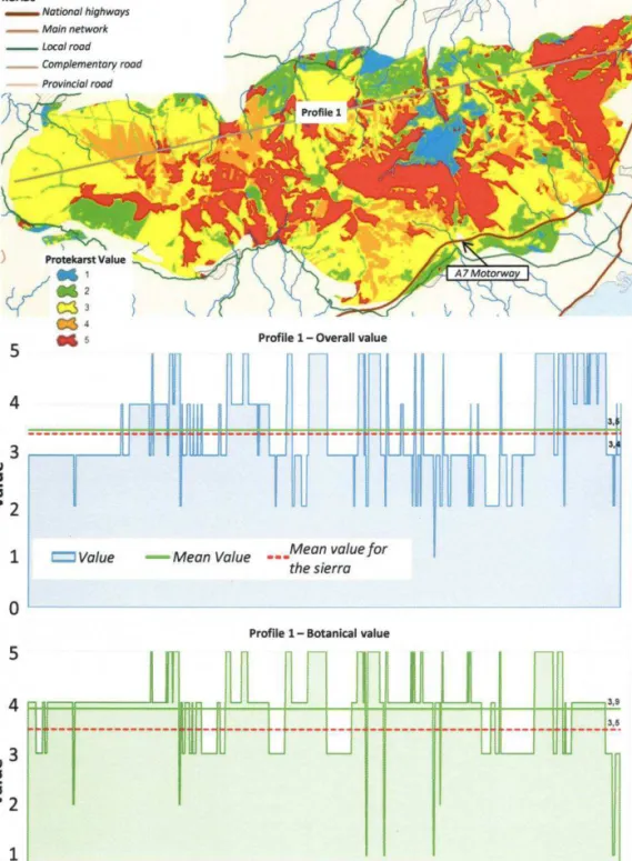
To evaluate proposed road infrastructure
The method can be used to determine the variation
in the overall grade of protection or in the
quantifica-tion of a specific parameter at different points along
the route of the proposed road infrastructure (Figure
3). This allows planners to identify the sectors of the
route that affect the most sensitive areas (i.e., those
rated at protection levels 4 and 5)
Moreover, the level of protection affected by a
given sector of an infrastructure route can be
com-pared with the average values for the entire route and
for those of the sierra (Figure 3). Thus, it is apparent
whether the area affected by the route in question is
above or below the mean protection value for the
si-erra, and whether the route passes through areas of
very high protection value, in terms of a specific
val-ue or of the overall level of protection (Figure 3).
To compare alternative routes
For this task, we propose, first, a simplified
scor-ing criterion, by which a threshold of significance is
selected for each region of the sierra (value 3).
Se-cond, the karst values used in the analysis of
alterna-tives must be identified, because the importance of
the different values considered will vary from one
ar-ea of the sierra to another. Finally, the different
pro-files must be created and the impact made by each
route on the karst values must be determined (Figure
4).
To evaluate significant impacts on karst values
by previous infrastructure projects
To assess the impact of construction work on karst
values, we must analyse the difference between the
initial value and that observed after the construction
(including any remedial action taken). For example,
the embankments of the A-7 motorway constructed
through the south-east sector of the study zone have
led to the almost complete disappearance of botanical
karst values from the area affected; other aspects,
such as scenic values, have suffered serious
degrada-tion, not only in the area directly affected by the
in-frastructure work but also along a much broader part
of the southern slope of the sierra. On the other hand,
the hydrogeological values of the area have not been
affected.
To define suitable routes
The results obtained highlight the potential of the
method for the proposal and basic definition of routes
or trails through karst areas of special interest.
Areas of very high protection (level 5) represent
26% of the surface area of the sierra and correspond,
in general, to areas with very high scores for
botani-cal and scenic parameters (Figure 2). In addition,
there are some small areas with the same protection
value on the northern edge of the sierra, which
corre-spond to irrigated plots (high economic value) and an
area in the central-eastern part of the sierra,
contain-ing Cueva del Toro, which has been declared an
El-ement of Cultural Interest (high archaeological
val-ue).
Areas of high protection (level 4) represent only
9% of the land surface and are located mainly in the
north-western and eastern sectors of the sierra, where
there coincide areas of high scenic, economic and
bo-tanical value (Figure 2).
Medium-level protection areas (level 3) are
pre-dominant in Sierra de Mijas, occupying 52% of the
land surface, and mainly reflect the economic,
zoo-logical, scenic and botanical values recorded here.
The areas with low and very low protection values
(levels 2 and 1), occupy 4% and 9% of the land
sur-face, respectively. These are areas with very low
bo-tanical and scenic scores, and include roads, quarries,
urban areas, areas devoid of natural vegetation and
areas where the vegetation is mainly nitrophilous.
4 CONTRIBUTION OF THE PROTEKARST
METHOD TO THE STUDY OF
INFRASTRUCTURES
The Protekarst method can contribute to the study of
infrastructures in the following ways:
To evaluate proposed road infrastructure
The method can be used to determine the variation
in the overall grade of protection or in the
quantifica-tion of a specific parameter at different points along
the route of the proposed road infrastructure (Figure
3). This allows planners to identify the sectors of the
route that affect the most sensitive areas (i.e., those
rated at protection levels 4 and 5)
Moreover, the level of protection affected by a
given sector of an infrastructure route can be
com-pared with the average values for the entire route and
for those of the sierra (Figure 3). Thus, it is apparent
whether the area affected by the route in question is
above or below the mean protection value for the
si-erra, and whether the route passes through areas of
very high protection value, in terms of a specific
val-ue or of the overall level of protection (Figure 3).
To compare alternative routes
For this task, we propose, first, a simplified
scor-ing criterion, by which a threshold of significance is
selected for each region of the sierra (value 3).
Se-cond, the karst values used in the analysis of
alterna-tives must be identified, because the importance of
the different values considered will vary from one
ar-ea of the sierra to another. Finally, the different
pro-files must be created and the impact made by each
route on the karst values must be determined (Figure
4).
To evaluate significant impacts on karst values
by previous infrastructure projects
To assess the impact of construction work on karst
values, we must analyse the difference between the
initial value and that observed after the construction
(including any remedial action taken). For example,
the embankments of the A-7 motorway constructed
through the south-east sector of the study zone have
led to the almost complete disappearance of botanical
karst values from the area affected; other aspects,
such as scenic values, have suffered serious
degrada-tion, not only in the area directly affected by the
in-frastructure work but also along a much broader part
of the southern slope of the sierra. On the other hand,
the hydrogeological values of the area have not been
affected.
To define suitable routes
The results obtained highlight the potential of the
method for the proposal and basic definition of routes
or trails through karst areas of special interest.
Figure 4. Using the Protekarst method to compare alternative routes.
ACKNOWLEDGEMENT
The authors would like to thank the ERDF of
Euro-pean Union for financial support via project
“Desa-rrollo de una metodología para la protección de las
regiones kársticas en relación con las infraestructuras
y otras actividades antrópicas (G-GI3000/IDIM)” of
the “Programa Operativo FEDER de Andalucía
2007-2013”. We also thank all Public Works Agency
and Regional Ministry of Public Works and Housing
of the Regional Government of Andalusia staff and
researchers for their dedication and professionalism
REFERENCES
Junta de Andalucía-Universidad de Málaga, 2014. Desarrollo de una metodología para la protección de las regiones kársticas en relación con las infraestructuras y otras actividades antrópicas (G-GI3000/IDIM). Unpublished report.
Structural damage caused by swelling of the foundation
soil: a case history
Dommages structurels causés par le gonflement du sol de fondation:
une étude de cas
C. Di Maio*, R. Vassallo and V. Caputo
University of Basilicata, Potenza, Italy
* Corresponding Author
ABSTRACT This paper reports the results of the analysis of the damage undergone by a school building constructed on a clayey slope at S. Arcangelo (Southern Italy). Differential uplift due to swelling of the foundation clay soil was hypothesized to be the cause of the observed damage. Actually, to build the school, the slope was excavated for about 11 m, thus producing both a decrease in stress and exposure to rain of the inner clay formation. Consequently, swelling pressure of the foundation soil has probably increased, becoming higher than the nor-mal stresses transmitted by the overlying building structure. This interpretation is consistent with the observed damage and with the results of laboratory tests carried out to evaluate swelling and swelling pressure of the clay due to exposure to a fluid simulating rain water. RÉSUMÉ Cet article présente les résultats de l'analyse du dommage subi par un bâtiment scolaire construit sur une pente argileuse à S. Ar-cangelo (Sud de l'Italie). Le soulèvement différentiel dû au gonflement des sols argileux de fondation a été considéré comme la cause pos-sible des dommages observés. En fait, pour construire l'école, la pente a été creusée d'environ 11 m, provoquant ainsi à la fois une diminu-tion de contrainte et l'exposidiminu-tion à la pluie de la formadiminu-tion argileuse intérieure. A cause de ces deux processus, la pression de gonflement du sol de fondation a probablement augmenté, devenant plus élevée que les tensions normales transmises par la structure de construction sus-jacente. Cette interprétation est compatible avec les résultats des tests de laboratoire effectués pour évaluer le gonflement et la pression de gonflement de l'argile due à l'exposition à un fluide simulant l'eau de pluie.
1 INTRODUCTION
Swelling of the foundation soil can cause severe damage to structures of various types. The tendency to swell can be induced by various causes, among which unloading and exposure to liquids which make the repulsive interparticle forces increase. Other possible causes are salt heave resulting from temperature related crystallization of sodium sulfate (Blaser & Scherer 1969; Blaser & Arunandan 1973), and expansion of sulfide minerals in shales resulting from oxidation caused by exposure to air and water (Dougherty & Barsotti 1972). In certain areas, also temperature variations can be such as to induce noticeable tendency to volume increase.
Di Maio (1996a, 1996b, 2001) showed that exposure to distilled water of smectitic clays reconstituted with salt solutions can cause significant
swelling. If swelling is not permitted, such a type of exposure causes a transient process of swelling pressure. This latter can be defined as the pressure required to keep a soil element at constant volume, when boundary conditions are such as to induce a tendency to volume increase. Swelling pressure is a very important parameter for the design of structures interacting with swelling soils and rocks. It must be evaluated to design safe shallow foundations (Abduljauwad et al. 1998) as well as deep foundations.