Structure of the Zagros fold and thrust belt in the
Kurdistan Region, northern Iraq
J.
DEV
ERA1*, J. G
INES2, M. O
EHLERS2, K. M
CC
LAY3ANDJ. D
OSKI31Now at: Shell, Rijswijk, Netherlands.
2Fugro NPA Ltd. Crockham Park, Edenbridge, Kent TN8 6SR, UK.
3Fault Dynamics Research Group, Royal Holloway University of London, TW20 EX, UK.
*e-mail: Jose.De-Vera@shell.com
Abstract: This study summarizes the regional structure of the Zagros fold and thrust belt in the Kurdistan Region of northern Iraq. The fold and thrust belt is dominated by a 10 to 12 km thick suc-cession of Late Proterozoic to present-day strata that have been deformed into a series of NW-SE- to E-W-trending and SW- to NE-verging doubly-plunging folds and associated thrust faults. Regional structural styles, topography and the distribution of recent seismicity in the region suggest the struc-ture of the fold belt is in part controlled by basement-involved strucstruc-tures.
Keywords: fold and thrust belt, Zagros, Iraq, Kurdistan, Middle East, remote sensing.
Iraq holds oil reserves of approximately 115 billion bar-rels, the third largest in the world. It is estimated that the Zagros fold and thrust belt in the Kurdistan Region of northern Iraq may contain up to 45 billion barrels of oil (Kurdistan Regional Government, 2007). However, unlike its Iranian counterpart, the fold and thrust belt in the Kurdistan has received very limited geological attention in the past decades due to major geopolitical problems. In addition, because of the scarcity of subsur-face data, the structure of the area remains poorly con-strained. This study has used remote sensing strati-graphic and structural mapping techniques to docu-ment the regional structure of the fold and thrust belt.
Plate tectonic setting and location of the study area
The Zagros orogenic belt resulted from the collision of the Arabian and Eurasian Plates in the Cenozoic up to the present day (Fig. 1). The Zagros orogenic belt extends for almost 2000 km across Iran and Iraq, through Syria (Figs. 1 and 2) and southeastern Turkey (Fig. 1). The tectonic evolution of the Zagros can be
summarized as a series of Late Proterozoic, Permian and Mesozoic rift events that were followed by closure of the ancient continental margin leading to conti-nental collision in the Cenozoic (e.g. Alavi, 2004, 2007) (Fig. 3).
The study area is located in the Kurdistan Regional Government Area, north of the cities of Kirkuk and Erbil (Fig. 2), and covers an area of approximately 25,000 km2. The structurally-controlled topography
of the area combined with the large size of individual structures and the generally good level of exposure make the Kurdistan an ideal area for remote sensing studies. The area was studied using multi-band Landsat ETM+ imagery and SRTM digital elevation models. The data were processed to enhance the spa-tial and the spectral resolution of the images.
Regional stratigraphy
thick succession of Proterozoic to recent continental to shallow water strata that were deposited on the continental margin of the Arabian Plate.
The oldest stratigraphic unit of the Kurdistan consists of Ordovician siliciclastic strata (Fig. 3) that are inter-preted as being unconformably overlying a crystalline basement of Proterozoic age (Jassim and Goff, 2006). In the study area, only Triassic to recent strata are exposed.
Most of the Mesozoic to Cenozoic succession is dom-inated by platform carbonates, with local presence of shales and evaporites (Fig. 3). Important carbonate units include the Cretaceous Shinaresh and Qamchuqa formations (reservoirs) and the Eocene Pila Spi formation. Unconformably overlying the Pila Spi formation are shales and evaporites of the Mioecene Fars group (seal). A thick wedge of conti-nental deposits of the Bakhtyari formation lies south-west of the Mountain Front in the Mesopotamian foreland basin (Fig. 3). The Bakhtyari formation is a growth strata unit that records uplift and denudation of the fold and thrust belt in the Plio-Pleistocene.
Regional structure
The Zagros fold and thrust belt in the Kurdistan Region is dominated by long, linear NW-S to E-W-trending and SE- to NE-verging doubly-plung-ing folds (Fig. 2) that locally change vergence along strike and are deformed on multiple detach-ments. Thrust faulting at the surface is limited to the northern part of the fold and thrust belt. Anticlines are typically defined by the weathering-resistant carbonates of the Eocene Pila Spi forma-tion and the Cretaceous. Individual fold length at the surface ranges from approximately 25 km to as much as 120 km and fold wavelengths typically vary from 2 to 10 km.
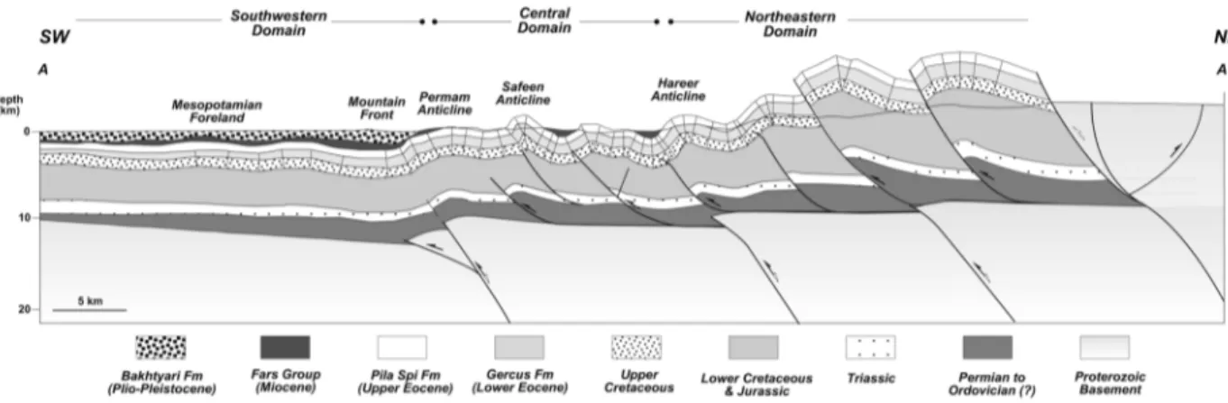
The structures are distributed in such a way that suc-cessively younger units are exposed from northeast to southwest (Figs. 3 and 4). Based on the distribution of stratigraphic units and structural styles, the study area can be subdivided into three distinct domains: a northeastern domain exposing dominantly Cretaceous strata that are thrust faulted and folded, a central domain composed dominantly of folded
Cretaceous to Miocene strata, and a southwestern domain dominated by relatively undeformed Plio-Pleistocene strata. The boundaries between these domains correlate with the present-day topography of the fold and thrust belt and are interpreted as reflect-ing underlyreflect-ing basement-involved faults (Fig. 4). The transition from the central to the southwestern domain defines the mountain front. The mountain front is delineated by the Permam anticline (Fig. 4) and separates a folded and faulted zone from a rela-tively undeformed succession of Pliocene to recent alluvial fans of the Bakthyari formation (Figs. 3 and 4). The mountain front is a regional-scale flexure that is here interpreted as the surface expression of a buried reverse fault in the basement. The geometry of the folds is locally modified by a series of N-S- to NNW-SSE-trending lineaments. These lineaments typically occur as an alignment of fold plunge termi-nations or fold deflections.
The distribution of map units combined with cross section construction suggests the presence of several detachment layers. The occurrence of a main detach-ment is inferred at the basedetach-ment-sedidetach-ment contact,
possibly in Ordovician and Silurian shales (Fig. 4). The presence of an intermediate detachment is inferred in the Jurassic strata and an upper, shallow-level detachment locally occurs in Miocene strata of the Fars group.
Discussion and conclusions
The Kurdistan fold and thrust belt is zoned and char-acterized by NW-SE-trending and SW-verging fault-related folds. The step-like topography of the region combined with a clear zonation at the level of expo-sure of different stratigraphic units and the distribu-tion of recent seismicity, suggests that the structure of the Kurdistan is at least in part controlled by base-ment-involved faults. Similar observations have been documented throughout the Zagros fold and thrust belt in Iran (e.g. Berberian, 1995; Sepher and Cosgrove, 2004). The aligment of fold plunge termi-nations and local deflection of fold trends along N-S-to NNW-SSE-trending lines is here used as permis-sive evidence for underlying basement structures. Similar trends have been described for the Iranian Zagros (e.g. Sepher and Cosgrove, 2004; Jassim and
Figure 2.Summary structural map of the Zagros fold and thrust belt in the Kurdistan region showing the traces of major folds and the regional distribution of stratigraphic units.
Goff, 2006; Alavi, 2007). Outstanding problems in Kurdistan include the structure at deep structural lev-els and the nature of the basal detachment layer. The Zagros fold and thrust belt in contiguous Iran is wide-ly interpreted as being detached on the Cambrian Hormuz Salt (e.g. Sepher and Cosgrove, 2004; Alavi, 2004, 2007). No rocks older than Ordovician are exposed in the Iraqi Kurdistan. It is possible that the Cambrian Salt pinches out to the northwest and that
the fold and thrust belt in the Kurdistan is detached on Ordovician and Silurian shales. Further work is needed to better constrain the structure of the area.
Acknowledgements
Fugro NPA and the Fault Dynamics Research Group are thanked for supporting this project. An anonymous reviewer is thanked for the thorough review of this manuscript.
Figure 4.Regional cross-section across the fold and thrust belt. Refer to figure 2 for location of the section.
References
ALAVI, M. (2004): Regional stratigraphy of the Zagros fold-thrust
belt of Iran and its proforeland evolution. Am. J. Sci., 304, 1-20.
ALAVI, M. (2007): Structures of the Zagros fold-thrust belt in Iran. Am. J. Sci., 307, 1067-1095.
BERBERIAN, M. (1995): Master “blind” thrust faults hidden under
the Zagros folds: active basement tectonics and surface morpho-tectonics. Tectonophysics, 241, 193-224.
JAMES, G. A. and WYND, J. G. (1965): Stratigraphic nomenclature of Iranian Oil Consortium Agreement Area. AAPG Bull., 49, 2182-2245.
JASSIM, S. Z. and GOFF, J. C. (2006): Geology of Iraq. Dolin,
Prague and Moravian Museum, Brno, 341 pp.
KURDISTANREGIONALGOVERNMENT(2007): In: Financial Times, April 2007.
NUMAN, N. M. S. (1997): A plate tectonic scenario for the
Phanerozoic succession in Iraq. Iraqi Geol. J., 30, 85 pp.
SEPHER, M. and COSGROVE, J. W. (2004): Structural framework
of the Zagros fold-thrust belt, Iran. Mar. Petrol. Geol., 21, 829-843.