Coupling Climate Conditions, Sediment Sources and Sediment Transport in an Alpine Basin
13
0
0
Texto completo
(2) CLIMATE, SEDIMENT SOURCES AND SEDIMENT TRANSPORT IN AN ALPINE BASIN. contraction and cleft propagation occurring with low temperatures. In glaciated basins, climate warming may lead increased water yield (Micheletti & Lane 2016), as well as increased sediment export by inducing permafrost degradation (Bennett et al. 2013) or by favoring the development of an enhanced sediment connectivity, as observed in the Haut Glacier d’Arolla (Swiss Alps) by Lane et al. (2017). On the other hand, precipitation patterns act both on sediment erosion along the hillslope (Rossi et al. 2010) and on the runoff regime (Bocchiola 2014). Several studies have explored the effects of recent climatic shifts on the hydrological regime (Geilhausen et al. 2013; Bennett et al. 2014), while the impacts on fluvial sediment dynamics have been poorly investigated because of a limited number of longlasting monitoring programs (Lane et al. 2017). Very few mountain basins are instrumented to investigate contemporary climate and hydrological trends, along with changes in sediment source areas and sediment fluxes, and thus, few quantitative long-term datasets (>10 year) are available. Studies that do capture these datasets were mainly conducted in glaciated or formerly glaciated basins, rarely focusing on non-glacial catchments. Analyzing two small and partially glaciated mountain catchments located in the Canton of Valais (Swiss Alps), Micheletti & Lane (2016) observed that climate variations occurring in the last 3 decades led to an increase in water yield and sediment transport capacity, but this trend was not accompanied by an increase in sediment export because of low hillslope-channel connectivity. Nonlinear behavior between rainfall, discharge and sediment export was observed by Lana-Renault et al. (2007) in a small unglaciated Pyrenees basin, highlighting the complexity of sediment dynamics in the catchment. The authors observed that rainfall is not the most significant controlling factor of sediment yield, stressing the importance of the continuity of cascading sediment flux, and thus of sediment connectivity (e.g. Cavalli et al. 2013; Heckmann & Schwanghart 2013). This evidence seems to suggest that in dynamic systems such as mountain catchments, climatic conditions permit only partial description of sediment export. By producing change in sediment storage landforms, erosion processes can lead to the creation of sediment sources that in the mountain basins can vary from large debris flow channels and flow deposits to shallow landslides (Lenzi et al. 2003; Messenzehl et al. 2014; Cavalli et al. 2017). Thus, by acting on the source areas, sediment erosion strongly controls fluvial sediment transport, which is essentially related to hydrological and sediment supply conditions (Mao et al. 2009; Recking 2012). In particular, the source areas control the amount of material delivered to the channel network, also defining in-channel features and influencing sediment mobility conditions (Yu et al. 2009; Piton & Recking 2017). This is particularly evident in small mountain basins, where the type and extent of sediment sources may strongly influence the nature, magnitude and efficiency of fluvial transport processes (Schuerch et al., 2006; Rainato et al. 2017). The material supplied by the slopes may reach the channel network or not, depending on Copyright © 2017 John Wiley & Sons, Ltd.. 1155. coupling/decoupling relationships between sediment sources and the channel network. In light of this, the sediment yield exhibited by the mountain basins, further to the climatic and hydrological conditions, is strongly controlled by the connectivity between source areas and the channel network (Bracken et al. 2015; Dell’Agnese et al. 2015). The presence/absence of hillslope-channel network coupling, and its degree, can influence the temporal response of the catchment to sediment supply variation. Indeed, a lagged response of basins, despite increased hillslope erosion, can be due to the absence of sediment connectivity between the slopes and drainage network (Bennett et al. 2013; Messenzehl et al. 2014). In this respect, small mountain basins offer a great opportunity to assess the sediment cascade continuity because here, hillslope-channel network coupling is characterized by rapid connectivity, both temporally and spatially (Sanjuán et al. 2016). This work aims to investigate the climate trends, evolution of sediment source areas and fluvial sediment fluxes in an Alpine basin over the last 3 decades. The quasi-unique monitoring program maintained in the Rio Cordon basin since 1986 allows us to (i) analyze the shifts in temperature and precipitation regimes and (ii) evaluate the response of sediment source areas, specifically, in terms of source evolution. After defining the sediment connectivity acting in the catchment, changes observed in the climate trends and source areas were compared to the sediment fluxes independently recorded at the outlet of the basin. Hence, the quasi-unique dataset provided by the Rio Cordon monitoring program was used to shed further light on the central, but only rarely analyzed, cause–effect coupling between climate forcing and sediment delivery patterns, providing insights to be compared with other monitored catchments. MATERIAL AND METHODS Study Area Rio Cordon is a mountain basin located in the Eastern Italian Alps (Dolomites). The catchment (Figure 1) covers an area of 5 km2 and the elevation ranges from 1,763 to 2,763 m. a.s.l.. While the average slope is 27°, this is locally exceeded along the subvertical cliffs located in the upper part of the basin, where slopes higher than 45° were detected (Trevisani et al. 2010). The basin is part of the Southern Calcareous Alps with prevalent dolomite and volcanic conglomerates (Wengen group) in the upper part, whereas sandstones and calcareous–marly rocks (Buchenstein group) characterize the lower part. Additionally, a wide presence of quaternary deposits (i.e. moraines, scree and landslide accumulations) can be observed throughout the study area (Cavalli et al. 2016). In the basin, three main soil types are noticeable: brown earth soil is widely spread, while the skeleton and organic soils are mainly present on the partially vegetated steep slopes and in the lower vegetated areas, respectively (Lenzi et al. 2004). In terms of climate, the Rio Cordon basin is characterized by Alpine climatic conditions with an average annual LAND DEGRADATION & DEVELOPMENT, 29: 1154–1166 (2018).
(3) 1156. R. RAINATO ET AL.. Figure 1. Location of the Rio Cordon basin (red outline) with respect to Caprile (a) and the Mondeval di Sopra and Rio Cordon stations in the basin (b). ‘Rio cordon station’ identifies both the meteorological and sediment transport monitoring station. The latitude-longitude (World Geodetic System 84) of the Rio Cordon monitoring station are 46.4505N and 12.0953E. [Colour figure can be viewed at wileyonlinelibrary.com]. precipitation of 1,150 mm. Between November and April, the precipitation occurs mainly as snowfall, while during the rest of the year, rainfall prevails. Consequently, the runoff exhibits a typical nivo-pluvial regime with snowmelt during the May–June period and periodical floods in summer and autumn due to rainstorm and persistent rainfall, respectively. In relation to the sediment cascade, the basin exhibits a wide presence of sediment sources, which consist mainly of debris flow channels and flow deposits, landslides and talus slopes. Overall, these areas cover roughly 13% of the basin (Ferrato et al. 2017). Because of the presence of a low-gradient belt located at approximately 2,200 m.a.s.l., the upstream sources provide a minor contribution to the sediment export (Dalla Fontana & Marchi 2003). Currently, the basin appears to be characterized by a low–moderate sediment-supply condition (Rainato et al. 2017). The Rio Cordon stream has developed its torrential system mainly over quaternary moraine and scree deposits. The average slope of the main channel is 17%, featuring a rough streambed with step-pool morphology and large boulders. The grain size distribution of surface material exhibits the percentiles D16/D50/D84 equal to 29/114/358 mm, respectively. Currently, the streambed is strongly armoured with the subsurface D50 (38 mm) threefold lower in respect to the surface D50 (Mao et al. 2010). The bankfull discharge was estimated by Lenzi et al. (2006) as equal to 2.30 m3 s 1. In terms of land use, Alpine grasslands and shrubs cover 60% and 15% of the basin area, respectively. Non-vegetated areas and bare rocks (i.e. subvertical cliffs) are present in 14% of the catchment, while the forested areas (Picea abies and Larix decidua) cover only the lower part, accounting for 6%. Anthropogenic influences are limited to a small number of hikers and seasonal grazing of bovine, donkeys, and sheep. Also, a total absence of artificial structures can be observed along the river network. Climate Data In the Rio Cordon basin, two meteorological stations were set-up by the Veneto Region (Experimental Centre of Arabba) and currently managed by ARPA Veneto. In 1986, Copyright © 2017 John Wiley & Sons, Ltd.. at 1,763 m.a.sl., the Rio Cordon station was established. Here, rainfall is continuously gathered by a heated rain gauge, while air temperature, atmospheric pressure, relative humidity and solar radiation have been constantly recorded since 1994. An additional meteorological station (Mondeval di Sopra station) equipped with a rain gauge and an air temperature sensor was established in 1992 at 2,130 m.a.sl. Climatic conditions are recorded hourly at both stations. This continuous monitoring provides a detailed description of the rainfall regime for the last 3 decades in the basin. For the aim of this paper, the time series produced by the heated rain gauge installed in the Rio Cordon station was used because it covers the entire period analyzed (i.e. 1986–2015). In relation to the air temperature regime, the two meteorological stations located in the basin do not provide data over the entire 1986–2015 period. In fact, the Mondeval di Sopra and Rio Cordon stations started to measure air temperature in 1992 and 1994, respectively. To address this issue, the temperature time series produced for Caprile was investigated. The Caprile meteorological station (ARPA Veneto) is located only 6 km south-west of the Rio Cordon basin, at 1,008 m.a.s.l. (Figure 1(a)). The Caprile time series was used because it is the closest meteorological station with continuous climate monitoring during the period 1986–2015. Sediment Sources Data During the 1986–2015 period, three inventories of potential sediment sources were created in the Rio Cordon basin. These investigations were carried out by a collaboration between University of Padova and National Research Council, Research Institute for Geo-Hydrological Protection that aimed to characterize the sources in terms of spatial extent, type and location. The first inventory is dated summer 1994 and is based both on geomorphic field surveys, performed using measuring tape and altimeter and on interpretation of aerial photographs (1:25,000 scale). The resulting inventory map (1:10,000 scale) was later integrated in to a GIS environment to permit comparison with subsequent inventories (Cavalli et al. 2016). The second inventory was carried out in late summer 2006 (Cavalli et al. 2016). First, the sediment sources LAND DEGRADATION & DEVELOPMENT, 29: 1154–1166 (2018).
(4) CLIMATE, SEDIMENT SOURCES AND SEDIMENT TRANSPORT IN AN ALPINE BASIN. characterization was performed through geomorphic field mapping with a hand-held GPS (Magellan, San Dimas, California, USA) receiver, laser rangefinder (Laser Technology, Centennial, Colorado, USA), measuring tape (Sport Italia, Forlì, Italy), and digital photo camera (Canon, Tokyo, Japan). Additionally, in October 2006, a Light Detection and Ranging flight was carried out to produce a digital terrain model. The high resolution (1 m) enabled investigation and mapping of sources not detected in the field because of their non-accessible location.. 1157. The most recent inventory was produced in 2016. Similar to the previous inventories, the 2016 mapping was started by field surveys performed with a GPS. To identify sediment sources located in unreachable areas photo interpretation was conducted on images derived by Bing® satellite service and Web Map Service service for AGEA (i.e. Italian Agricultural Payments Agency). In both cases, the images used are from 2012, but the absence of significant variations in the unreachable areas has permitted use of the images in the 2016 inventory.. Figure 2. Different types of sediment source areas mapped in the Rio Cordon basin: Debris flow channel and flow deposit (a); mud flow deposit generated by the evolution of a landslide occurred in 2001 (b); erosional area (c); eroded stream bank (d); shallow landslide (e); landslide which occurred in 2001 (f); and active talus (g). Small wetland areas (h) were also mapped. [Colour figure can be viewed at wileyonlinelibrary.com] Copyright © 2017 John Wiley & Sons, Ltd.. LAND DEGRADATION & DEVELOPMENT, 29: 1154–1166 (2018).
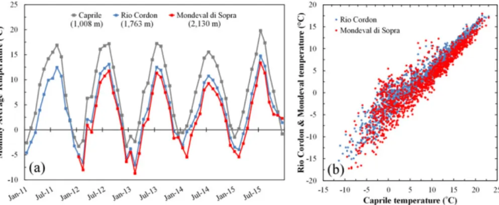
(5) 1158. R. RAINATO ET AL.. Over the three inventories, the source areas were geometrically surveyed (without any evaluation of thickness) and classified into seven types (Figure 2): • Debris flow channel: All channels affected by debris flow (Figure 2(a)). Even triggering areas, if not clearly attributable to other processes (e.g. shallow landslides), were classified in this source type. Because of the access limitations of steep channels in which debris flow processes occur, the geometry of this sediment source type was approximately mapped in the field; • Debris flow deposit: Depositional areas related to debris flow events (Figure 2(a)). A mud-flow deposit (Figure 2 (b)) derived from a landslide of fine-medium grain size material (Figure 2(f)) occurred during the snowmeltinduced flood of May 11, 2001, but for simplicity was included in the debris flow-deposit category; • Erosional area: Is a sediment source type widespread on catchment slopes (Figure 2(c)). This type refers to areas affected by erosional processes: all unvegetated areas or with poor grass cover, with marked evidence of erosion activity not related to landslides, were classified as erosional area. In the Rio Cordon basin, rill erosion is the most common form of surficial erosion and originates by both steep gradient slopes and anthropic causes, particularly the intensive cattle grazing that leads to the progressive grass cover degradation; • Eroded stream bank: Channel network banks presenting erosion, mainly triggered by the water flow (Figure 2 (d)). The distinction between eroded stream bank and erosional area is justified by the great importance for sediment dynamics played by sources belonging to the former type and due to their direct link with the channel network; • Landslide: Steep debris-mantled slope where the action of gravity is the primary driving force. All the detected landslides initiated in sediment (Figure 2(f)); • Rockfall deposit: Depositional areas related to rockfall events; and • Active talus: Sediment eroded from rock cliffs temporarily stored as scree deposits on talus slopes (Figure 2(g)). Moreover, small wetland areas (Figure 2(h)) that display an important role in the deposition and entrapment of sediments were also surveyed but not considered as sediment sources. Further details on the Rio Cordon inventories and on the methodology used can be found in Cavalli et al. (2016) and Ferrato et al. (2017). Sediment Connectivity In order to depict spatial patterns of sediment connectivity in the catchment, a topography-based index of sediment connectivity (IC; Cavalli et al. 2013) was applied. In this work the index, expressing the potential connection between hillslope and selected targets, is aimed at evaluating the potential linkage between the hillslope domain and basin outlet. IC was computed through SedInConnect 2·0 (Crema et al. 2015) using a LiDAR-derived digital terrain model at Copyright © 2017 John Wiley & Sons, Ltd.. 1 m resolution (Cavalli et al. 2016) and a weighting factor based on surface roughness. Further details on the methodology can be found in Cavalli et al. (2013). Fluvial Sediment Fluxes Data In the Rio Cordon basin, the fluvial sediment fluxes have been continuously recorded since 1986 by a long-term monitoring program. The program was established through a collaboration between University of Padova and Veneto Region that in 1985 led to the construction of a permanent monitoring station designed for the continuous measurement of water discharge (Q), suspended sediment load (SSL) and bedload (BL). Located at 1,763 m.a.s.l. (i.e. basin outlet), the monitoring station measures Q by two water gauges (Sakura Endress, Yamanashiken, Japan) and a sharp-crested weir, while SSL is assessed by two turbidimeters (Partech, St Austell, UK and Hach, Loveland, Colorado, USA). Specifically, the sampling time resolution is 1 h during ordinary flow conditions (Q < 1 m3 s 1), and increases to 5 min for Q > 1 m3 s 1. In the period 1986–2015, a time fraction of 15% presented data gaps in relation to the water discharge or suspended load. An inclined metallic grid enables the coarse material (D > 20 mm) of bedload events to be separated from the water flow. Once separated, the bedload falls into a storage area where 24 ultrasonic sensors measure the transport rate. To achieve a higher estimation accuracy, since 2012, a terrestrial laser scanner (Leica, Wetzlar, Germany) has been used to estimate the amount of coarse material deposited in the storage area. The volume data obtained is then converted to mass using a sediment density of 2.65 Mg m3 and a material porosity of 35%. In relation to the cause–effect coupling between climate forcing and sediment delivery patterns, the research activities performed in the Rio Cordon Alpine basin led to the availability of a quasi-unique dataset. Overall, the dataset (1986–2015) permits the investigation of sediment source response (i.e. sediment source data) to long-term climate trends (i.e. climate data). In turn, it is possible to analyze whether, and how, the trends of climatic condition and evolution of sediment source areas cause a response in fluvial sediment fluxes (i.e. fluvial sediment fluxes data). RESULTS Climate Trends The trends of the monthly average air temperature recorded by the Caprile (1,008 m.a.s.l.), Rio Cordon (1,763 m.a.s.l.) and Mondeval di Sopra (2,130 m.a.s.l.) meteorological stations during 2011–2015 (Figure 3(a)) show the presence of an elevation gradient. The temperature shifts that occurred in the Rio Cordon basin appear to be well described by the Caprile station. Comparing the hourly temperatures recorded in the 2011–2015 period, a roughly linear relationship can be observed between the temperature recorded by the Caprile station and the Rio Cordon and Mondeval di Sopra measurements (Figure 3(b)). According to the Pearson correlation coefficients (r), Rio Cordon and Caprile LAND DEGRADATION & DEVELOPMENT, 29: 1154–1166 (2018).
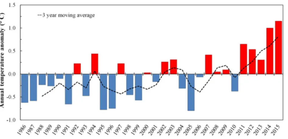
(6) CLIMATE, SEDIMENT SOURCES AND SEDIMENT TRANSPORT IN AN ALPINE BASIN. 1159. Figure 3. Monthly average air temperature in Mondeval di Sopra (2,130 m.a.s.l.), Rio Cordon (1,763 m.a.s.l.) and Caprile (1,008 m.a.s.l.; a). Rio Cordon– Caprile and Mondeval di Sopra temperature relationships (b). [Colour figure can be viewed at wileyonlinelibrary.com]. temperatures were strongly correlated (r = 0·96, p < 0.01). A significant correlation (r = 0·92, p < 0.01) also exists between Mondeval di Sopra and Caprile. Therefore, because of the absence of a long-term temperature time series record in the Rio Cordon basin, the Caprile dataset was used in this study as it covers the study period. The mean annual air temperature for Caprile over the 1986–2015 period is 6.9 °C (Table I). The trend of mean annual temperature as deviation from the 1986–2015 average (i.e. annual temperature anomaly) seems to suggest the Table I. Mean annual air temperature and annual precipitation recorded in the 1986–2015 period at Caprile and Rio Cordon meteorological stations, respectively. 1986 1987 1988 1989 1990 1991 1992 1993 1994 1995 1996 1997 1998 1999 2000 2001 2002 2003 2004 2005 2006 2007 2008 2009 2010 2011 2012 2013 2014 2015. Temperature (°C). Rainfall (mm). 6.3 6.3 6.7 6.6 6.8 6.2 7.1 6.4 7.3 6.1 6.2 7.1 6.4 6.3 6.9 6.7 7.2 7.2 6.6 6.1 6.8 7.3 7.0 7.0 6.5 7.6 7.4 7.2 7.9 8.0. 967 1,281 907 1,158 996 934 1,194 1,068 1,096 856 1,200 890 976 1,200 1,409 949 1,358 930 841 1,097 898 1,134 1,587 1,322 1,325 1,180 1,597 1,612 1,757 1,016. Copyright © 2017 John Wiley & Sons, Ltd.. occurrence of three distinct stages during the study period. Initially, between 1986 and 1991, the temperature constantly exhibits a negative anomaly, with annual averages lower than the 30-year average (Figure 4). In the period 1986–1991, the mean temperature (6.5 °C) was clearly lower than the 1986– 2015 average, with the coldest year recorded in 1991 with an anomaly of 0.7 °C (i.e. mean annual = 6.2 °C). Since 1992, the temperature regime was characterized by a high inter-annual variability with a succession of positive and negative anomalies that lasted until 2006. In this period, the warmest year was recorded in 1994 with a temperature anomaly of +0.4 °C. On the other hand, the highest negative anomaly equal to 0.8 °C (i.e. mean annual = 6.1 °C) was measured both in 1995 and in 2005. Such years were the coldest of the last 30 years. Since 2007, the mean annual temperatures were constantly above the 1986–2015 average, with an increase in positive anomalies (Figure 4). The only exception to this trend was 2010, with a negative anomaly of 0.4 °C. From 2007, the mean temperature was 7.3 °C, corresponding to an increase of 5.8% in respect to the 1986–2015 average. Also, in 2015, the highest temperature of the whole 1986–2015 period was recorded, with a positive anomaly equal to +1.1 °C. Rainfall recorded by the Rio Cordon meteorological station shows that between 1986 and 1999, the annual precipitation was relatively constant, with limited inter-annual variability (Figure 5). Since 2000, significant shifts in the precipitation regime were observed. In 2000, 2001 and 2002, annual precipitation was recorded as 1,409, 949 and 1,358 mm, respectively (Table I). These amounts clearly differ from each other and from the 1986–2015 average (i.e. 1,157 mm y 1). From 2003 to 2006, a period characterized by an almost constant significant reduction in rainfall was observed. During this 4-year period, the average precipitation was 942 mm, and 2004 (841 mm) was the driest year of the last 3 decades. Since 2007, a long period of increased precipitation was recorded. Particularly, the mean annual precipitation between 2007 and 2015 was 1,392 mm, 20% higher than the 1986–2015 average. The wettest year of the entire study period was 2014 (1,757 mm) (Table I). The increase observed since 2007 was partially offset by 2015, when the annual rainfall was 1,015 mm. LAND DEGRADATION & DEVELOPMENT, 29: 1154–1166 (2018).
(7) 1160. R. RAINATO ET AL.. Figure 4. Average annual temperature in Caprile as the deviation from the 1986–2015 mean. Black dotted line is the 3-year moving average of the anomaly. [Colour figure can be viewed at wileyonlinelibrary.com]. Trend of Hillslope Sediment Sources In 1994, 292 sources were detected, covering a total area of 498,265 m2, with an average extent of 1,706 m2. In terms of extent, active talus slopes (174,423 m2) was the predominant source type. In 1994, the 24 mapped talus areas exhibited an average surface area of 7,268 m2 and were detected mainly at the foot of the subvertical cliffs located in the upper part of the basin (Figure 6). Erosional areas were also particularly vast (160,241 m2), with an average extent (2,428 m2) notably lower than the active talus. More than 160 landslides were identified in the basin by the 1994 inventory, extending over a total area of 149,197 m2 (Table II). Compared with these source types, the areas affected by stream bank erosion and debris flow (channels and deposits) were approximately two orders of magnitude lower, covering 5,517 and 8,887 m2, respectively. Overall, in 1994 the active source areas covered 9·9% of the basin surface. Additionally, 13 wetlands, extending on average 3,588 m2, were detected (Table II). On the other hand, in 2006, more than 400 source areas were identified, covering 648,554 m2. The average area (1,548 m2) slightly decreased from 1994. As in the first inventory, the largest source type in 2006 was active talus, which is mainly located in the upper part of the basin (Figure 6). The 26 active taluses exhibited an average area (8,084 m2) larger than in the previous inventory. More. than 190 landslides were mapped in 2006, with several new sources activated along the left side of the lower basin (i.e. south-south-east). In this inventory, the landslides showed an average surface area comparable with that observed in 1994. In total, this source type accounted for a surface area of 191,797 m2. Erosional area covers a similar areal extent, but this type was characterized by larger individual sources (average area = 1,745 m2). However, compared with the results obtained in 1994, erosional area is less extensive ( 39%). Since the 2006 inventory, debris flow channels and flow deposits were separately mapped (Table II). This classification highlighted that, with respect to debris flow channels, debris flow deposits were larger both in terms of total and average area. Overall, 78 source areas were related to debris flow processes, covering an area (71,623 m2) clearly higher than in 1994. Such an increase is not evident in the average area, which remains similar to that observed in the previous inventory. Also in 2006, eroded stream bank was observed in the lower extent of the basin (3,902 m2), with 22 sediment sources covering on average just 177 m2. Overall, in 2006 the active source areas covered 12.9% of catchment area. Total and average area of wetlands was fully comparable with that observed in 1994 (Table II). Finally, the source area inventory performed in 2016 showed an extent comparable with 2006. Despite a slight decrease in the average area ( 4%), the active talus remained. Figure 5. Monthly and annual precipitation in the Rio Cordon basin during the 1986–2015 period. The red dotted line is the 3-year moving average of the annual precipitation. [Colour figure can be viewed at wileyonlinelibrary.com] Copyright © 2017 John Wiley & Sons, Ltd.. LAND DEGRADATION & DEVELOPMENT, 29: 1154–1166 (2018).
(8) CLIMATE, SEDIMENT SOURCES AND SEDIMENT TRANSPORT IN AN ALPINE BASIN. 1161. surface area ( 5%). An opposite trend can be observed in the erosional area. Compared with 2006, debris flow channels and debris flow deposits showed a different evolution. In fact, the debris flow channels increased both in terms of total (+23%) and average area (+17%), while debris flow deposits decreased in both. Notably, eroded stream bank reduced in extent, with the average area nearly twofold lower compared with 2006. Interestingly, in 2016, a massive rockfall deposit (20,676 m2) was detected along the northeastern cliffs (Figure 6). The deposit obliterated more than 10,000 m2 of previously classified active talus (Table II). Overall, during this last period, the extent of the catchment covered by sediment source areas remains exactly the same. Similarly, the wetlands exhibited only a slight reduction in terms of average area ( 8%). In general, it should be noted that the 1994 sediment source database is characterized by a lower accuracy and completeness with respect to the most recent ones. Accordingly, the comparative quantitative analysis with the 2006 and 2016 databases needs to be carried out in a critical manner, as reported in Cavalli et al. (2016). Sediment Connectivity Analysis The map of IC highlighting the potential degree of linkage between hillslope and catchment outlet is presented in Figure 7. This analysis highlights that high connectivity values characterize the lower sector of the catchment, which is characterized by steep slopes and a narrow valley. In this part of the basin, most of the sediment sources on hillslopes can be considered well connected to the outlet. Different spatial patterns of connectivity can be observed in the middle and upper parts of the study area. Lower IC values suggest that the low-gradient belt and several depressions characterizing the middle part of the basin strongly affect the sediment fluxes, favoring deposition and retainment of sediment and, thus, decoupling sediment sources located in these areas from the outlet. Fluvial Sediment Fluxes Trends. Figure 6. Sediment source inventories performed in the Rio Cordon basin in 1994, 2006 and 2016. [Colour figure can be viewed at wileyonlinelibrary.com]. the main source type. In 2016, a considerable portion of the basin remains affected by landslides, which slightly increased in total area (+2%) while decreased in average Copyright © 2017 John Wiley & Sons, Ltd.. The long lasting monitoring of fluvial sediment transport in the Rio Cordon enables us to assess the sediment fluxes that occurred during the last 30 years. During the period 1986–2015, a total of 15,110 Mg was exported from the basin to the monitoring station as suspended sediment load and bedload (Figure 8). The total load recorded corresponds to an annual sediment yield equal to 504 Mg yr 1 (i.e. 100 Mg km 2 yr 1). Overall, during the study period, the suspended load fraction (SSLf = 0·79) clearly prevails over the bedload fraction (BLf = 0·21). In terms of temporal trends, the sediment yield reflects the high inter-annual variability exhibited by suspended load and bedload. Between 1986 and 1993, the annual sediment yield was continuously lower than 1,000 Mg yr 1, except in 1991, with SSLf always above 0.60. As a consequence of the September 1994 exceptional event, more than 4,000 Mg were exported from the basin in 1994. In this year, bedload (1,543 Mg) and suspended LAND DEGRADATION & DEVELOPMENT, 29: 1154–1166 (2018).
(9) 1162. R. RAINATO ET AL.. Table II. Type, extent and evolution of sediment sources over the inventories performed in the Rio Cordon basin in 1994, 2006 and 2016. In 2006 and 2016, the debris flow type is the sum of the debris flow channel and flow deposit Type. Debris flow channel deposit Erosional area Eroded stream bank Landslide Active talus Rockfall deposit Total source areas Wetland Stabilized Obliterated. 1994. 2006. 2016. Area (m2). Count (n). Av. area (m2). Area (m2). Count (n). Av. area (m2). Area (m2). Count (n). Av. area (m2). 8,887 n/a n/a 160,241 5,517. 10 n/a n/a 66 25. 889 n/a n/a 2,428 221. 71,623 15,340 56,283 171,050 3,902. 78 38 40 98 22. 918 404 1,407 1,745 177. 70,816 18,845 51,971 162,406 1,734. 78 40 38 85 22. 908 471 1,368 1,911 79. 149,197 174,423 0 498,265 46,641 n/a n/a. 167 24 0 292 13 n/a n/a. 893 7,268 0 1,706 3,588 n/a n/a. 191,797 210,182 0 648,554 43,293 2,693 n/a. 195 26 0 419 12 19 n/a. 984 8,084 0 1,548 3,608 142 n/a. 195,151 201,316 20,676 652,100 43,453 18,773 10,719. 208 26 1 420 13 33 5. 938 7,743 20,676 1,553 3,343 569 2,144. load (2,524 Mg) exhibited the highest magnitude ever recorded. Between 1994 and 2003, significant fluctuations can be observed in the sediment fluxes (Figure 8), with the annual sediment yield varying by two orders of magnitude. Specifically, the annual sediment export at the monitoring station ranged between 12 Mg recorded in 2003 to 1,743 Mg assessed in 2001. Large annual shifts can be observed also in the partitioning, with SSLf varying from 0.59 to 1.00 recorded in 1998 and 1997, respectively. Since 2003, the annual sediment yields were consistently lower than 600 Mg yr 1. In the last 13 years an evident decrease of bedload yield was observed with magnitude constantly <100 Mg yr 1 and BLf < 0.30. A minor interruption to this. Figure 7. Sediment connectivity map. [Colour figure can be viewed at wileyonlinelibrary.com] Copyright © 2017 John Wiley & Sons, Ltd.. trend was recorded in 2014 (BLf = 0.31), when 118 Mg of coarse material were exported from the basin. DISCUSSION Despite the high complexity of the mountain system and the complex interplay of different controlling factors (i.e. topography, runoff and sediment availability), the availability of the quasi-unique dataset provided by the Rio Cordon monitoring program permits us to assess the cause–effect coupling between climate forcing and sediment delivery patterns. Specifically, the continuous measurement of climatic conditions and sediment fluxes were analyzed in combination with the three sediment source inventories representative of sediment availability in the basin in the last 30 years. The analysis focused on the trends exhibited during the inter-periods, that is, 1986–1993, 1994–2006 and 2007–2015. In the Rio Cordon, the climate and fluvial sediment flux datasets are generally of good quality because they are produced by monitoring stations constantly managed by ARPA Veneto (Rainato et al. 2017). Between 1986 and 1993, the climatic conditions appear relatively stable both in terms of temperature and in terms of rainfall. During this period, the mean temperature was 6.6 °C, with the standard deviation (SD = 0.30 °C) of the annual values confirming that no significant fluctuations occurred. Likewise, rainfall exhibited a low inter-annual variability (SD = 136 mm), with an average precipitation equal to 1,063 mm. Similar to what was observed in the small and formerly glaciated Val Müschauns (Swiss Alps) by Messenzehl et al. (2014), the sediment source area inventories in the Rio Cordon are generally dominated by active talus, erosional area and landslides. In 1994, the sources appeared altogether quite distant from the channel network (Figure 6). Fluvial sediment fluxes showed a stable trend during the 1986–1993 period, similar to the trend exhibited by the climatic conditions. The mean annual sediment yield was 339 Mg yr 1, with clear prevalence of SSL fraction LAND DEGRADATION & DEVELOPMENT, 29: 1154–1166 (2018).
(10) CLIMATE, SEDIMENT SOURCES AND SEDIMENT TRANSPORT IN AN ALPINE BASIN. 1163. Figure 8. Annual sediment yield recorded by the Rio Cordon monitoring station during the 1986–2015 period. The red dotted line is the 3-year moving average of the total load (i.e. SSL + BL). [Colour figure can be viewed at wileyonlinelibrary.com]. (SSLf = 0.85). Climatically, the 1994–2006 period was somewhat similar to the 1986–1993 period but exhibited larger inter-annual fluctuations. Indeed, the average temperature (6.7 °C) was in line with that observed in the previous phase, while SD increased to 0.44 °C. The same trend can be observed in precipitation, with mean and SD equal to 1,053 and 190 mm, respectively. In addition to the climatic conditions, during the period 1994–2006, source area change was strongly affected by the occurrence of high magnitude/low frequency flood events. Particularly, the September 1994 exceptional event strongly impacted the Rio Cordon basin, creating new source areas and reactivating old ones (Rainato et al. 2017), while in May 2001, a large mudflow occurred along a small tributary located in the lower part of the basin, creating an extended debris fan (~4,176 m3) (Lenzi et al. 2004). The 2006 source inventory showed a noticeable increase (+30%) in terms of total area. This change is affected by a certain degree of uncertainty because of the use of geomorphic field mapping to characterize the sediment sources and, particularly, by the different methodology used in the 2006 inventory survey compared with the 1994 survey (Cavalli et al. 2016). As argued by several authors (Bishop et al. 2012; Messenzehl et al. 2014), field mapping is subject to a certain error range, rarely computed, and mainly because of the subjectivity and the uncertainty derived by time-consuming field operations. Nevertheless, geomorphic field mapping is largely used to investigate sediment cascades in mountain environments, enabling researchers to obtain qualitative results scarcely achieved by quantitative approaches (Messenzehl et al. 2014). The effect of using a diverse methodology between 1994 and 2006 is clearly evident in the number of sources detected and in the total area (Table II). Principally, the increase observed is due to the higher accuracy used to describe the debris flow type (+62,736 m2). Nevertheless, a certain increase in this type seems to have occurred, as suggested by the increased average surface. Interestingly, the climatic fluctuations and the high magnitude/low frequency floods increased the number, extent and average area of landslides. Such variation is particularly evident in Copyright © 2017 John Wiley & Sons, Ltd.. the lower part of the basin along the slopes next to the channel network (Figure 6). Compared with that noted in 1994, in 2006, a higher number of erosional areas were observed along the hillslopes, but they were smaller on average (Figure 6). This evolution could be explained by climate forcing between 1994–2006 or by extensive cattle grazing occurring in the catchment (Cavalli et al. 2016). Notwithstanding the high magnitude/low frequency floods, eroded stream bank was reduced compared with 1994. This decrease seems to suggest that the channel network rapidly exhausted the sediment availability here created by the high magnitude events. In 12 years (1994–2006), eroded stream bank was stabilized or reduced by supplying and increasing the transport efficiency of the post-September 1994 floods (Rainato et al. 2017). In the 1994–2006 period, the partitioning (BLf = 0.15) was fully comparable with that observed in the 1986–1993 period. In this sense, the increase of active talus and landslides did not lead to a variation in the BL and SSL fractions. The partitioning clearly varied only in the years with high magnitude/low frequency floods such as 1994 (BLf = 0.38), 1998 (BLf = 0·41) and 1999 (BLf = 0·31), that is, under conditions of effective connectivity between source areas and channel network. On the other hand, sediment export exhibited a strong increase, with a mean annual sediment yield equal to 759 Mg yr 1. In this sense, the key role played by the exceptional September 1994 flood is evident. However, sediment export remains high (i.e. 484 Mg yr 1) even excluding 1994 from the analysis. The shifts observed in the climatic conditions, and the relative change of sediment source areas seems to only partially explain the augmented sediment export measured in the 1994–2006 period, stressing the role played by the inchannel sediment availability resulting from the removal of the armour layer and bedforms by the September 1994 flood. The 2007–2015 period showed an evident increase both in terms of average temperature (7.3 °C) and in terms of mean precipitation (1,392 mm). This increasing trend appears to be more stable in the temperature data, exhibiting an inter-annual variability (SD = 0.48 °C) in line with that observed in the 1994–2006 period. On the other hand, LAND DEGRADATION & DEVELOPMENT, 29: 1154–1166 (2018).
(11) 1164. R. RAINATO ET AL.. precipitation was characterized by significant annual fluctuations (SD = 256 mm). This climate forcing resulted in a very limited sediment source changes. The number of landslides increased slightly, while the decreased extent of active talus was mainly due to the effect of the 2016 rockfall, which obliterated ~10,000 m2 previously classified as active talus (Table II). In addition to the climatic conditions, cattle grazing concentrated in specific areas of the basin could explain the variation in erosional area, which decreased in total count ( 15%) but increased in average area. In the period 2007–2015, the increased precipitation was not accompanied by an intensification of flood occurrence, which may explain the reduction observed in eroded stream bank compared with the 1994–2006 period. The decrease of fluvial bedload fraction (BLf = 0.07) seems to somehow reflect this sediment source evolution. Generally, the climatic trend recorded in the 2007–2015 period did not produce an increase in erosion processes in the Rio Cordon basin. This hypothesis also seems to be supported by the increase in stabilized areas and by the reduction of small wetlands (Table II). The absence of a significant change of sediment source areas due to climate forcing, combined with the armoring of the channel network, seems to explain the significant decrease observed in sediment export during the 2007–2015 period, when the mean annual sediment yield was 237 Mg yr 1. Compared with glaciated basins, nonglacial catchments usually exhibit lower erosion rates but higher sediment exports because of confined valley morphology and, hence, by the high transport efficiency of the stream (Hinderer 2001; Mao et al. 2009). Notwithstanding the unglaciated nature of the Rio Cordon basin, the sediment fluxes were generally limited, stressing the key role played by the evident sediment disconnectivity (Figure 7). Particularly, the upper part of the basin is clearly decoupled from the outlet, reducing the potential contribution of active talus, that is, the dominant source type. Overall, a large number of current sediment sources are located away from the channel network, in areas not usually coupled to the main channel (Figure 6). A comparable degree of sediment disconnectivity is normally observed in glaciated Alpine basins because of the presence of hanging valleys or inherited glacial landforms (Cavalli et al. 2013; Heckmann & Schwanghart 2013; Messenzehl et al. 2014; Micheletti & Lane 2016). In the Rio Cordon basin, the low-gradient belt located at 2,200 m.a.s.l. acts as the main buffer within the sediment cascade continuity. Consequently, the current state of disconnectivity appears quite stable in time because it is imposed by steady geomorphic conditions. As demonstrated by several authors (Messenzehl et al. 2014; Micheletti et al. 2015), the presence of a buffer within the sediment cascade makes it difficult to fully comprehend the consequence of recent climate change on sediment fluxes. In this sense, the effect of decoupling between sediment sources and the channel network was clearly observed in the period 2007–2015 when the increase in temperature and precipitation was not reflected by an intensification of sediment export. Clear evidence of this scenario was also the rockfall Copyright © 2017 John Wiley & Sons, Ltd.. that occurred in 2016, affecting a large surface and mobilizing massive amounts of material but not resulting in any effects in terms of fluvial sediment fluxes. Moreover, a high transport efficiency was achieved only recently in 2012 and 2014 when floods supported by an effective hillslopechannel network coupling occurred (Rainato et al. in press). In light of ongoing climate change, it will be interesting to assess how long this disconnected status will last. The potential change induced by the climate on erosion processes (Stott & Mount 2007) could lead to an enhanced sediment cascade condition and, in turn, to a lagged and massive response of the basin (Messenzehl et al. 2014). FINAL REMARKS This study investigated the climate trends, the relative sediment source areas evolution and the fluvial sediment export response exhibited by an Alpine basin over the last 3 decades. The research activities performed in the Rio Cordon basin led to the availability of a quasi-unique dataset based on the continuous measurement of temperature, precipitation, fluvial sediment fluxes and three sediment source inventories established in 1994, 2006 and 2016. The analysis focused on the trends exhibited during the periods 1986–1993, 1994–2006 and 2007–2015. In terms of climatic conditions, three distinct climate forcing stages can be observed in the periods analyzed: a relatively stable phase (1986–1993), a period characterized by temperature and rainfall fluctuations (1994–2006) and a more recent warmer and wetter phase (2007–2015). In the 1986–1993 period, the fluvial sediment fluxes reflected the stable trend exhibited by the climatic conditions. In the subsequent 1994–2006 period, the average temperature and precipitation were in line with that previously observed although with higher interannual variability. Notwithstanding the climate forcing and the occurrence of high magnitude/low frequency floods that strongly influenced the source areas, between 1994 and 2006, the Rio Cordon basin showed relatively limited erosion activity. Hence, the climatic conditions and the change in sediment source areas can only partially explain the significant increase in sediment export recorded in the 1994–2006 period. In this sense, the sediment availability resulting from armour layer and bedform removal appears crucial to describing the sediment fluxes during this period, stressing the key role of in-channel sediment supply. In the recent period 2007–2015, a marked climate warming accompanied by increased precipitation was observed. This climate forcing did not affect the evolution of sediment landforms, with sediment source extent remaining similar between 2006 and 2016. The absence of a significant response from sediment source areas and the restoration of the channel armour layer can describe the limited sediment fluxes observed during the last decade. In particular, the increased temperature and precipitation were not accompanied by an increase in flood occurrence and magnitude, stressing the evident sediment disconnectivity. In the Rio Cordon, as in similar mountain basins, it will be interesting to monitor LAND DEGRADATION & DEVELOPMENT, 29: 1154–1166 (2018).
(12) CLIMATE, SEDIMENT SOURCES AND SEDIMENT TRANSPORT IN AN ALPINE BASIN. and investigate how long the current (dis)connectivity status will be maintained, particularly in light of climate change that could rapidly alter the sediment dynamics observed so far. In this work, the results suggest a non-linear behavior between climatic condition, landform response and sediment dynamics, emphasizing the high complexity of the mountain systems. Very few unglaciated mountain basins are instrumented to investigate contemporary climate trends, the change of sediment source areas and sediment export. As a result, quantitative long-term data are particularly rare. The quasi-unique monitoring program maintained in the Rio Cordon basin since 1986 enabled us to analyze whether, and how, the trends of climatic condition and sediment landform evolution can influence fluvial sediment fluxes, stressing the role played by the presence/absence of hillslope-channel connectivity and shedding further light on the complex sediment delivery processes acting in mountain basins.. ACKNOWLEDGEMENTS This research was funded by the University of Padova Research Projects ‘Sediment transfer processes in an Alpine basin: Sediment cascades from hillslopes to the channel network — BIRD167919’, and ‘Source areas and channel networks. Increasing the knowledge on sediment connectivity around Alpine basins’ DOR1701834/17. We would like to thank Prof. Mario Aristide Lenzi because the article has benefited from discussion with him, as well as Matteo Cesca (ARPA Veneto) for the technical support. Many thanks go to Alison Garside for revising the English. We are grateful to Karoline Messenzehl and David Morche for their constructive comments, which helped us to improve the manuscript.. REFERENCES Ashmore PE, Church M. 2001. The impact of climate change on rivers and river processes in Canada. Bulletin of the Geological Survey of Canada 555: 1–48. Baewert H, Morche D. 2014. Coarse sediment dynamics in a proglacial fluvial system (Fagge River, Tyrol). Geomorphology 218: 88–97. Bennett G, Molnar P, McArdell B, Burlando P. 2014. A probabilistic sediment cascade model of sediment production, transfer and yield in the Illgraben. Water Resources Research 50: 1225–1244. https://doi. org/10.1002/2013WR013806. Bennett G, Molnar P, McArdell B, Schlunegger F, Burlando P. 2013. Patterns and controls of sediment production, transfer and yield in the Illgraben. Geomorphology 188: 68–82. Bishop MP, James LA, Shroder JF, Jr, Walsh SJ. 2012. Geospatial technologies and digital geomorphological mapping: concepts, issues and research. Geomorphology 137: 5–26. Bocchiola D. 2014. Long term (1921-2011) changes of alpine catchments regime in northern Italy. Advances in Water Resources 70: 51–64. Bracken LJ, Turnbull L, Wainwright J, Bogaart P. 2015. 2015. Sediment connectivity: a framework for understanding sediment transfer at multiple scales. Earth Surface Processes and Landforms 40: 177–188. https://doi.org/10.1002/esp.3635. Buendia C, Vericat D, Batalla RJ, Gibbins CN. 2016. Temporal dynamics of sediment transport and transient in-channel storage in a highly erodible. Copyright © 2017 John Wiley & Sons, Ltd.. 1165. catchment. Land Degradation & Development 27: 1045–1063. https:// doi.org/10.1002/ldr.2348. Carrivick JL, Chase SE. 2011. Spatial and temporal variability in the net mass balance of glaciers in the Southern Alps, New zealand. New Zealand Journal of Geography and Geophysics 54: 415–429. Cavalli M, Goldin B, Comiti F, Brardinoni F, Marchi L. 2017. Assessment of erosion and deposition in steep mountain basins by differencing sequential digital terrain models. Geomorphology 291: 4–16. https:// doi.org/10.1016/j.geomorph.2016.04.009. Cavalli M, Tarolli P, Dalla Fontana G, Marchi L. 2016. Multi-temporal analysis of sediment source areas and sediment connectivity in the Rio Cordon catchment (Dolomites). Rendiconti Online Società Geologica Italiana 39: 27–30. Cavalli M, Trevisani S, Comiti F, Marchi L. 2013. Geomorphometric assessment of spatial sediment connectivity in small Alpine catchments. Geomorphology 188: 31–41. Comiti F, Da Canal M, Surian N, Mao L, Picco L, Lenzi MA. 2011. Channel adjustments and vegetation cover dynamics in a large gravel bed river over the last 200 years. Geomorphology 125: 147–159. Crema S, Schenato L, Goldin B, Marchi L, Cavalli M. 2015. Toward the development of a stand-alone application for the assessment of sediment connectivity. Rendiconti Online della Società Geologica Italiana 34: 58–61. Dalla Fontana G, Marchi L. 2003. Slope-area relationships and sediment dynamics in two Alpine streams. Hydrological Processes 17: 73–87. Dell’Agnese A, Brardinoni F, Toro M, Mao L, Engel M, Comiti F. 2015. 2015. Bedload transport in a formerly glaciated mountain catchment constrained by particle tracking. Earth Surface Dynamics 3: 527–542. https://doi.org/10.5194/esurf-3-527-2015. Ferrato C, De Marco J, Tarolli P, Cavalli M. 2017. An updated source areas inventory in the Rio Cordon catchment (Dolomites). Rendiconti Online Società Geologica Italiana. Fischer M, Huss M, Hoelzle M. 2014. Surface elevation and mass changes of all Swiss glaciers 1980–2010. Cryosphere Discussions 8: 4581–4617. Geilhausen M, Morche D, Otto JC, Schrott L. 2013. Sediment discharge from the proglacial zone of a retreating Alpine glacier. Zeitschrift für Geomorphologie 57: 29–53. Harden CP, Scruggs PD. 2003. Infiltration on mountain slopes: a comparison of three environments. Geomorphology 55: 5–24. Heckmann T, Schwanghart W. 2013. Geomorphic coupling and sediment connectivity in an Alpine catchment — exploring sediment cascades using graph theory. Geomorphology 182: 89–103. https://doi.org/ 10.1016/j.geomorph.2012.10.033. Hinderer M. 2001. Late Quaternary denudation of the Alps, valley and lake fillings and modern river loads. Geodinamica Acta 14: 231–263. Hinderer M, Kastowski M, Kamelger A, Bartolini C, Schlunegger C. 2013. River loads and modern denudation of the Alps — a review. EarthScience Reviews 118: 11–44. Hirabayashi Y, Mahendran R, Koirala S, Konoshima L, Yamazaki D, Watanabe S, Kim H, Nakae S. 2013. Global flood risk under climate change. Nature Climate Change 3: 816–821. Jones AP. 2000. Late Quaternary sediment sources, storage and transfers within mountain basins using clast lithological analysis: Pineta Basin, Central Pyrenees, Spain. Geomorphology 34: 145–161. Keesstra SD, van Huissteden J, Vandenberghe J, Dam OV, de Gier J, Pleizier ID. 2005. Evolution of the morphology of the river Dragonja (SW Slovenia) due to land-use changes. Geomorphology 69: 191–207. Lana-Renault N, Regüés-Muñoz D, Martí-Bono CE, Beguería S, Latrón J, Nadal-Romero E, Serrano-Muela P, García-Ruiz JM. 2007. Temporal variability in the relationships between precipitation, discharge and suspended sediment concentration in a small Mediterranean mountain catchment. Nordic Hydrology 38: 139–150. Lane SN, Bakker M, Gabbud C, Micheletti N, Saugy JN. 2017. Sediment export, transient landscape response and catchment-scale connectivity following rapid climate warming and Alpine glacier recession. Geomorphology 277: 210–227. https://doi.org/10.1016/j.geomorph.2016.02.015. Le Pera E, Sorriso-Valvo M. 2000. Weathering, erosion and sediment composition in a high-gradient river, Calabria, Italy. Earth Surface Processes and Landforms 25: 277–292. Lenzi MA, Mao L, Comiti F. 2003. Interannual variation of suspended sediment load and sediment yield in an Alpine catchment. Hydrological Science Journal 48: 899–915. Lenzi MA, Mao L, Comiti F. 2004. Magnitude-frequency analysis of bed load data in an Alpine boulder bed stream. Water Resourced Research 40: 1–12. LAND DEGRADATION & DEVELOPMENT, 29: 1154–1166 (2018).
(13) 1166. R. RAINATO ET AL.. Lenzi MA, Mao L, Comiti F. 2006. Effective discharge for sediment transport in a mountain river: computational approaches and geomorphic effectiveness. Journal of Hydrology 326: 257–276. Liébault F, Gomez B, Page M, Marden M, Peacock D, Richard D, Trotter CM. 2005. Land-use change, sediment production and channel response in upland regions. River Research and Applications 21: 739–756. López-Tarazón JA, Batalla RJ, Vericat D, Francke T. 2012. The sediment budget of a highly dynamic mesoscale catchment: the river Isábena. Geomorphology 138: 15–28. Mao L, Cavalli M, Comiti F, Marchi L, Lenzi MA, Arattano M. 2009. Sediment transfer processes in two alpine catchments of contrasting morphological settings. Journal of Hydrology 364: 88–98. Mao L, Comiti F, Lenzi MA. 2010. Bedload dynamics in steep mountain rivers: insights from the Rio Cordon Experimental Station (Italian Alps). In Bedload-surrogate monitoring technologies, U.S. Geological Survey scientific investigations report 2010–5091, Gray JR, Laronne JB, Marr JDG (eds); 253–265, available only online from http://pubs.usgs.gov/ sir/2010/5091/papers/listofpapers.html. Menzel L, Burger G. 2002. Climate change scenarios and runoff response in the Mulde catchment (Southern Elbe, Germany). Journal of Hydrology 267: 53–64. Messenzehl K, Hoffmann T, Dikau R. 2014. Sediment connectivity in the high-Alpine valley of Val Müschauns, Swiss National Park — linking geomorphic field mapping with geomorphometric modelling. Geomorphology 221: 215–229. Michael A, Schmidt J, Enke W, Deutschlander T, Malitz G. 2005. Impact of expected increase in precipitation intensities on soil loss results of comparative model simulations. Catena 61: 155–164. Micheletti N, Lane SN. 2016. Water yield and sediment export in small, partially glaciated Alpine watersheds in a warming climate. Water Resources Research 52: 4924–4943. https://doi.org/10.1002/ 2016WR018774. Micheletti N, Lane SN, Lambiel C. 2015. Investigating decadal scale geomorphic dynamics in an Alpine mountain setting. Journal of Geophysical Research: Earth Surface 120: 2155–2175. Milly PCD, Wetherald RT, Dunne KA, Delworth TL. 2002. Increasing risk of great floods in a changing climate. Nature 415: 514–517. Montgomery DR, Buffington JM. 1997. Channel-reach morphology in mountain drainage basins. Geological Society of America Bulletin 109: 596–611. Morche D, Haas F, Baewert H, Heckmann T, Schmidt KH, Becht M. 2012. Sediment transport in the proglacial Fagge River (Kaunertal/Austria). In Erosion and sediment yields in the changing environment, Vol. 356, Collins AL, Golosov V, Horowitz AJ, Lu X, Stone M, Walling DE, Zhang X (eds). IAHS Publication: IAHS Press Wallingford; 72–81. Moretto J, Rigon E, Mao L, Picco L, Delai F, Lenzi AM. 2014. Channel adjustments and island dynamics in the Brenta River (Italy) over the last 30 years. River Research and Applications 30: 719–732. Picco L, Sitzia T, Mao L, Comiti F, Lenzi MA. 2016. Linking riparian woody communities and fluviomorphological characteristics in a regulated gravel-bed river (Piave river, Northern Italy). Ecohydrology 9: 101–112.. Copyright © 2017 John Wiley & Sons, Ltd.. Piton G, Recking A. 2017. The concept of travelling bedload and its consequences for bedload computation in mountain streams. Earth Surface Processes and Landforms 42: 1505–1519. https://doi.org/ 10.1002/esp.4105. Rainato R, Mao L, Garcia-Rama A, Picco L, Cesca M, Vianello A, Preciso E, Scussel GR, Lenzi MA. 2017. Three decades of monitoring in the Rio Cordon instrumented basin: sediment budget and temporal trend of sediment yield. Geomorphology 291: 45–56. https://doi.org/10.1016/j. geomorph.2016.03.012. Rainato R, Mao L, Picco L. in press. Near-bankfull floods in an Alpine stream: effects on the sediment mobility and bedload magnitude. International Journal of Sediment Research. https://doi.org/10.1016/j. ijsrc.2017.03.006. Recking A. 2012. Influence of sediment supply on mountain streams bedload transport. Geomorphology 175-176: 139–150. https://doi.org/ 10.1016/j.geomorph.2012.07.005. Rossi M, Witt A, Guzzetti F, Malamud BD, Peruccacci S. 2010. Analysis of historical landslides in the Emilia–Romagna region, northern Italy. Earth Surface Processes and Landforms 35: 1123–1137. Sanjuán Y, Gómez-Villar A, Nadal-Romero E, Álvarez-Martínez J, Arnáez J, Serrano-Muela MP, Rubiales JM, González-Sampériz P, García-Ruiz JM. 2016. Linking land cover changes in the sub-Alpine and montane belts to changes in a torrential river. Land Degradation and Development 27: 179–189. https://doi.org/10.1002/ldr.2294. Sass O, Oberlechner M. 2012. Is climate change causing increased rockfall frequency in Austria? Natural Hazards and Earth System Science 12: 3209–3216. Schuerch P, Densmore AL, McArdell BW, Molnar P. 2006. The influence of landsliding on sediment supply and channel change in a steep mountain catchment. Geomorphology 78: 222–235. Stott T, Mount N. 2007. Alpine proglacial suspended sediment dynamics in warm and cool ablation seasons: implications for global warming. Journal of Hydrology 332: 259–270. Syvitski JPM, Kettner AJ, Peckham SD, Kao SJ. 2005. Predicting the flux of sediment to the coastal zone: application to the Lanyang watershed, Northern Taiwan. Journal of Coastal Research 21: 580–587. Tarolli P, Sofia G. 2016. Human topographic signatures and derived geomorphic processes across landscapes. Geomorphology 255: 140–161. Trevisani S, Cavalli M, Marchi L. 2010. Reading the bed morphology of a mountain stream: a geomorphometric study on high-resolution topographic data. Hydrology and Earth System Sciences 14: 393–405. https://doi.org/10.5194/hess-14-393-2010. Yu G, Wang Z, Zhang K, Chang T, Liu H. 2009. Effect of incoming sediment on the transport rate of bed load in mountain streams. International Journal of Sediment Research 24: 260–273. Zhu YM, Lu XX, Zhou Y. 2008. Sediment flux sensitivity to climate change: a case study in the Longchuanjiang catchment of the upper Yangtze River, China. Global and Planetary Change 60: 429–442.. LAND DEGRADATION & DEVELOPMENT, 29: 1154–1166 (2018).
(14)
Figure


+4

![Figure 7. Sediment connectivity map. [Colour figure can be viewed at wileyonlinelibrary.com]](https://thumb-us.123doks.com/thumbv2/123dok_es/7317100.451008/9.892.75.825.151.427/figure-sediment-connectivity-map-colour-figure-viewed-wileyonlinelibrary.webp)

Documento similar
The photometry of the 236 238 objects detected in the reference images was grouped into the reference catalog (Table 3) 5 , which contains the object identifier, the right
Aportaciones a la Geomorfología de España en el inicio del tercer milenio. Sensitivity of alpine fluvial environments in the Swiss Alps to climate forcing during the Late
By combining measurements of primary production data, algorithm-generated fluxes below the upper sediment trap, fluxes measured at the three sediment trap-levels, and mean
The mixing intensity was related to the structural characteristics of the aggregates, and the outcomes were linked to the yield stress of the flocculated pulp sediment.. The
This effect may be related to an increase in particle collision (homoaggregation and het- eroaggregation) due to stirring in combination with resuspension of the sediment by
The method extends the positive definite non-oscillatory finite element algorithm (NFEM) capabilities to predict sediment transport, multiphase flow, and evolution of the
In addition, precise distance determinations to Local Group galaxies enable the calibration of cosmological distance determination methods, such as supernovae,
A catchment model for river basins and a hydrodynamic model were combined in order to simulate the spreading of the turbidity plume produced by sediment discharges from the
