A methodology to analyse and assess pumping management strategies in coastal aquifers to avoid degradation due to seawater intrusion problems
19
0
0
Texto completo
(2) is due to there are many coastal regions with important water demands. Some of them support towns with large populations as well as intensive agricultural and/or industrial activities. If surface water resources are scarce and/or intermittent – a frequent state of affairs on the Mediterranean coast – water supply must be partly or totally met using groundwater resources (Sola et al., 2013). They can be also useful to obtain nonconventional resources from desalination plants (Rodriguez-Estrella and Pulido-Bosch, 2009). Appropriate management rules must be applied for a sustainable use of groundwater resources to supply demands due to the urban and agricultural development (Robins et al., 1999; Bellot et al., 2007; Grundmann et al., 2012; Zouahri et al., 2015). Usually, a certain degree of overpumping (pumping volumes greater than the renewable resources) occurs, particularly in summer, which leads to salinization processes with seawater progressing into the aquifer (Rosenthal et al., 1992). On the other hand, the global change scenarios for the Mediterranean region show an expected increment in these difficulties to meeting coastal system demands, due to the reduction in freshwater recharge, the sea level rise and the increment in water demanded by irrigation uses (Fujinawa , 2011; March et al., 2014; Santos et al., 2014, Unsal et al., 2014). The management of these water resources systems linked to sea presents additional complexity (with physical and/or management particularities) due to the need to consider the effect of the interaction between freshwater and seawater and the salinization process (Pulido-Leboeuf et al., 2003: Daniele et al., 2011). The processes influencing groundwater level and freshwater-saltwater interface is an important issue in coastal aquifer research. They depend on aquifer stratigraphy and other hydrodynamic factors (precipitation regime, tides, wave setup and storm surges, etc) (Vallejos et al., 2015). The coastal aquifers have important hydrodynamic and hydrogeochemical peculiarities (Custodio, 2010; Werner et al., 2013). Any change in a component of the water balance, whether natural or anthropogenic, can alter the balance of freshwater-saltwater, sometimes quite significantly, and this can lead to a progression of the seawater intrusion (Kaman et al., 2011; Yechieli and Sivan, 2011; Arslan & Demir, 2013). Depending on the hypothesis and simplifications assumed different mathematical models have been applied to approach coastal aquifer behaviors (Bobba, 1993; Khublaryan et al., 2008). A more accurate representativeness of the physical process involved in saltwater intrusion processes can be obtained with the density dependent models, in which flow and transport code are couple to simultaneously run and updated in each time steps. There are many example of applications of these simulation models in the literature (Shammas and Thunvik, 2009; Doulgeris and Zissis, 2014; Unsal et al., 2014) But, sometimes they are not applied due to the scarcity of reliable estimates of parameters (eg. Dispersion coefficients (Naji et al., 1999)) and variables and their computational requirements (Sreekanth and Datta, 2010). This computational disadvantage is exacerbated when solving optimization. 2.
(3) management problems due to the multiple calls of the optimization algorithm to the simulation model (Dhar and Datta, 2009). Other approaches, the sharp interface solutions, assume that there is not mixing between fresh and saltwater obtaining simpler solutions in terms of required parameters and computational requirements (Llopis-Albert and PulidoVelazquez, 2014). Due to these computational advantages many application of these sharp interface solutions can be found to solve management optimization problems (AtaieAshtiani and Ketabchi, 2011; Sreekanth and Datta, 2011; Uddameri et al., 2014;). Although a direct use of finite difference groundwater flow models as MODFLOW code is not the most appropriate to modeling coastal aquifer processes, it is still a very employed approximation that can be useful to asses management alternatives in some cases (PulidoVelazquez et al., 2008; Rejani et al., 2009; Liu et al., 2010; Llopis-Albert and PulidoVelazquez, 2015; Hugman et al., 2015). Over the last decade, the application of the EU Water Framework Directive (EU-WFD, 2000, Willaarts et al., 2014; Indset et al., 2015), has promoted the development of research work about sustainable use and management of groundwater in coastal aquifers (Ferreira da Silva and Haie, 2007; Hugman et al., 2015; Senent-Aparicio et al., 2015). To prevent progress of marine intrusion inland, the fresh groundwater flows to the sea must be maintained. Contrary to the old-fashion belief that this fresh water is "a lost resource ", it is actually a case of gaining resources, at least over medium term horizons. To reduce the effect of intrusion in the most intensely affected areas, the pumping volumes need to be reduced so as to avoid piezometric drawdown in areas close to the shoreline. Though marine intrusion can be a hydrodynamically very complex process, it can be assumed that there is a direct relationship between the flow of fresh groundwater towards the sea and marine intrusion. As a consequence, the determination of the coastal groundwater discharges under different scenarios is important to analyze management alternatives (Zhou, 2014; Hugman et al., 2015). The classical sustainable and optimal yield concept has been extensively applied to analyze groundwater management problems (Peralta et al., 2011; Mays, 2013). It could be also applied to study sustainability in coastal aquifers management (Don et al., 2006; McCoy and Corbett, 2009; Liu and Dai, 2012; El-Kadi et al., 2014; Unsal et al., 2014;). Again, its application has additional difficulties due to the higher complexity of the coastal aquifer processes and their modeling approximation. Some research works in coastal aquifers use the inversion of the hydraulic head gradient as the criteria to obtain the sustainable yield (Hugman et al., 2015; El-Kadi et al., 2014). In this paper we propose a new systhematic method based on an approximation of the safe yield concept for coastal aquifers and a simple model approach to the problem. It is a novel simple approach that intend to help in the decision making process. The objective is to assess the reduction in pumping that would be required to achieve sustainability, whereby intrusion is less or equal to that estimated under natural regime. It is based on a. 3.
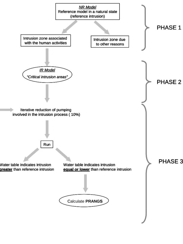
(4) sustainable yield criterion, in which the natural discharge is considered as the optimal yield that must be maintained in order that the seawater intrusion does not progress, preserving conditions similar to the natural state as the WFD promotes. Due to groundwater discharges to sea depend on the stresses applied in the aquifer. we need to identify what changes in anthropogenic activities should be applied for a sustainable management of the aquifer. The methodology was applied to a well-known Spanish Mediterranean aquifer, the Oropesa-Torreblanca Plain aquifer.. Methodology The target is to quantify, on overexploitation aquifers, the minimum pumping reduction necessary to achieve that seawater inflows for areas with intrusion problems do not exceed the estimated value under a natural regime ("reference intrusion"), for humid (PRANGS h), intermediate (PRANGSi) and dry years (PRANGSd). We intend to solve an optimization problem (for each of the representative humid, intermediate and dry conditions), whose objective function is to minimize the reduction in pumping whilst ensuring intrusion does not exceed what would occur under a natural regime. Its solution requires a simulation model that provides a valid approximation to assess seawater intrusion. In this paper we employ a constant density groundwater flow simulation model. Although these models do not predict the effect of the variable density on the groundwater flow, they are tools which, for certain cases and objectives, may be suitable to simulate these systems (Iríbar et al., 1997; Rejani et al., 2008; Nettasana et al., 2012; Psarropoulou and Karatzas, 2012; Salcedo-Sánchez et al., 2012). The optimization problem has been solved by using a heuristic iterative process and a constant density flow simulation model of the aquifer, which assumes a direct relationship between piezometric drawdown and seawater intrusion. Under these assumptions, the procedure for calculating the Pumping Reduction to Achieve a Natural Good Status (PRANGS) can be divided into three phases (Figure 1): Phase 1: Sea-Aquifer interaction under natural and influenced regime: The seaaquifer flow exchange is evaluated for conditions representative of humid (PRANGSh), intermediate (PRANGSi) and dry years (PRANGSd). A constant density groundwater simulation model is employed to assess these flows as a function of the freshwater levels near the coast. Two steady-state scenarios are evaluated for each scenario (humid, intermediate and dry years): 1) the influenced steady state regime obtained (IR model) considering the human stresses applied to the aquifer;. 4.
(5) 2) The natural regime or reference intrusion scenario (NR model), simulated from the IR model by eliminating the pumping and irrigation returns associated with human activity. Phase 2: Identification and delimitation of the "critical intrusion areas" and their wells. The IR and NR model solutions are compared to identify areas where, as a consequence of pumping, the saltwater flow increases with respect the natural regime ("critical intrusion areas"). For each of these areas, we assess the surface area affected by the seawater intrusion and the wells considered as the principal cause of the problem. Phase 3: Assessment of the reduction in pumping required in each critical area to prevent intrusion problems (PRANGS). The following optimization problem is considered: minimize the reduction of pumped extractions from wells in the critical areas identified, whilst complying with the constraint that no new critical intrusion area appears (compared to the natural regime, NR model) nor that existing intrusion intensifies. We propose an iterative procedure to obtain an approximate solution to this problem. The process begins by running the model with pumping in the selected wells reduced by 10%. This process is repeated until the solution satisfies the constraints outlined above. The PRANGS for a critical marine intrusion area is expressed as the reduction in the volume of abstraction that satisfies the restrictions in that area. It is adequately determined by comparing the pumping volume for the IR model with the pumping of the last simulated scenario that satisfies the constraints. The difference is the Pumping Reduction to Achieve a Natural Good Status (PRANGS). In low inertial aquifer systems, the hydrodynamic response of the freshwater-seawater interaction to the change in natural recharge values is rapid and direct, particularly in regions of highly irregular rainfall. This means that the PRANGS can take a wide range of values. For this reason, we calculate the PRANGS separately for humid (PRANGSh), intermediate (PRANGSi) and dry years (PRANGSd).. Case study: PRANGS of the Oropesa-Torreblanca Plain Aquifer (Spain) The Oropesa-Torreblanca Plain lies in the north of Castellón province (eastern Spain). It is a coastal aquifer that extends for 21 km parallel to the coast in a NE-SW direction, with a width of between 2.5 and 6 km, covering approximately 80 km2 (Figure 2). A more or less horizontal coastal plain and a outwash fan towards the edges of the surrounding limestone massifs can be differentiated. The geometry of the aquifer is lenticular with minimum. 5.
(6) thickness in the interior and maximum near the coast, exceeding 80 meters at the mouths of the rivers Estopet and Chinchilla (Figure 2).. NR Model Reference model in a natural state (reference intrusion). PHASE 1 Intrusion zone associated with the human activities. Intrusion zone due to other reasons. IR Model “Critical intrusion areas”. PHASE 2. Iterative reduction of pumping involved in the intrusion process ( 10%). Run. Water table indicates intrusion greater than reference intrusion. Water table indicates intrusion equal or lower than reference intrusion. PHASE 3. CalculatePRANGS ERV Calculate. Figure 1. Methodological scheme for the PRANGS calculation. 6.
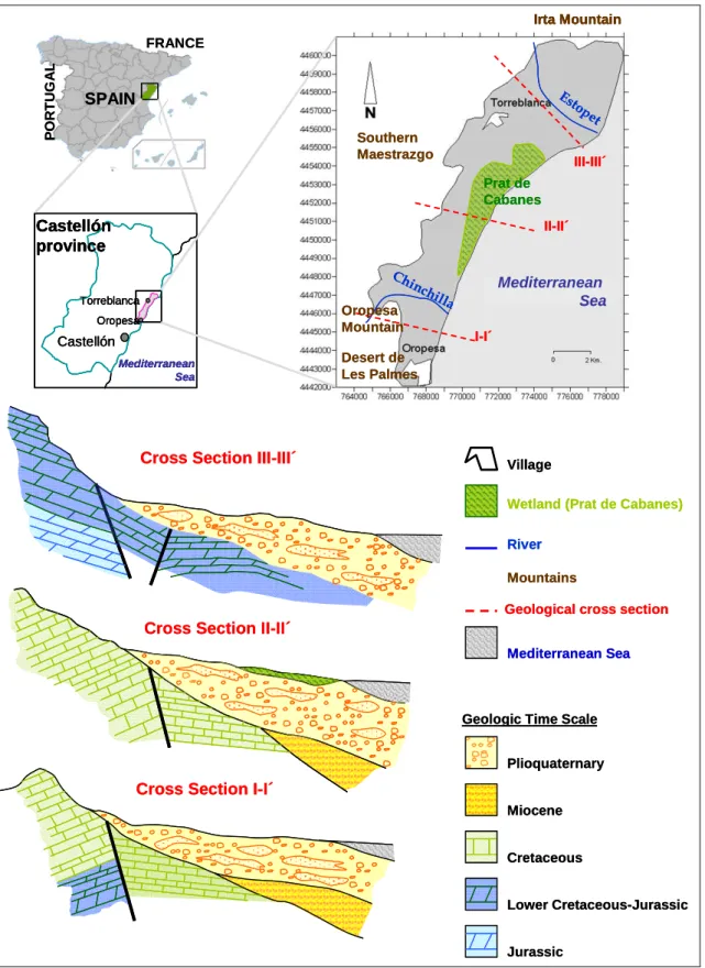
(7) Irta Mountain. PORTUGAL. FRANCE. Es. SPAIN Southern Maestrazgo. to p. et. III-III´ Prat de Cabanes. Castellón province. II-II´. Ch inc. Torreblanca. Oropesa Mountain. Oropesa. Castellón Mediterranean Sea. Cross Section III-III´. Mediterranean Sea. hil la. I-I´. Desert de Les Palmes. Village Wetland (Prat de Cabanes) River Mountains Geological cross section. Cross Section II-II´ Mediterranean Sea. Geologic Time Scale Plioquaternary. Cross Section I-I´ Miocene Cretaceous Lower Cretaceous-Jurassic Jurassic. Figure 2. Location map and geological cross sections of the study area. 7.
(8) The hydrogeological boundaries of the aquifer are defined in the north by the CretaceousJurassic limestone outcrops of the Irta Mountain. The western flank is formed by the Aptian and Gargasian (Cretaceous) limestone massif, which is in hydraulic connection with the Plioquaternary aquifer (except in the immediate vicinity of the Chinchilla ravine and river Estopet where the impermeable Miocene base appears). To the south, it is limited by the Cretaceous limestone of the Oropesa Mountain. In the east, the aquifer is hydraulically connected to the sea (Morell and Giménez, 1997) (Figure 2). It is composed of Plioquaternary detrital deposits, comprising limestone pebbles, gravel and conglomerates derived from the adjacent mountain ranges, with abundant lenses of coarse sand, silt and clays. There are frequent lateral and vertical changes of facies and the overall distribution is irregular, overlain by more recent alluvial fans, colluvium, dunes and peatlands. A wide range of transmissivity is defined, varying from 5000 m2/day to 100 m2/day (Morell and Giménez, 1997). The effective porosity is calculated to be between 2% and 12%, with the highest porosity next to the coastline inflows to the system consist of lateral groundwater transfers from neighboring aquifers, infiltration from precipitation, and irrigation returns. Outflows comprise the pumped abstractions, together with groundwater discharges to sea and seeps/springs in the wetland that is found in the central sector. The estimated water balance for the Plioquaternary aquifer, is given in table 1. The direction of the groundwater flow under natural conditions is NW-SE, perpendicular to the coastline. Table 1. Long-therm water balance of the Oropesa-Torreblanca Plain 3. 3. INPUT (hm /year). OUTPUT (hm /year). Intrusion. 2.2. Discharges to sea. 4.5. Lateral groundwater transfers. 38.0. Pumped abstractions. 39.0. Recharge (irrigation returns + rainfall). 6.8. Wetland. 3.5. TOTAL. 47.0. TOTAL. 47.0. In the centre of the Oropesa-Torreblanca Plain is located a wetland called Prat de Cabanes. It is composed of brown and black silt and loam, with a recognized peat level some 3 to 4 meters thick, which is commercially exploited. Prat de Cabanes is an elongated area, some 9 km long by an average of 1 km. It is oriented parallel to the coast and congruent with the dominant structural lines (NE-SW). It is separated from the sea by a coastal bar some 8 km long, 20 m wide and 3 m high, consisting of sorted pebbles, ranging between 1 cm and 20 cm (Figure 2).. PRANGS Calculation. 8.
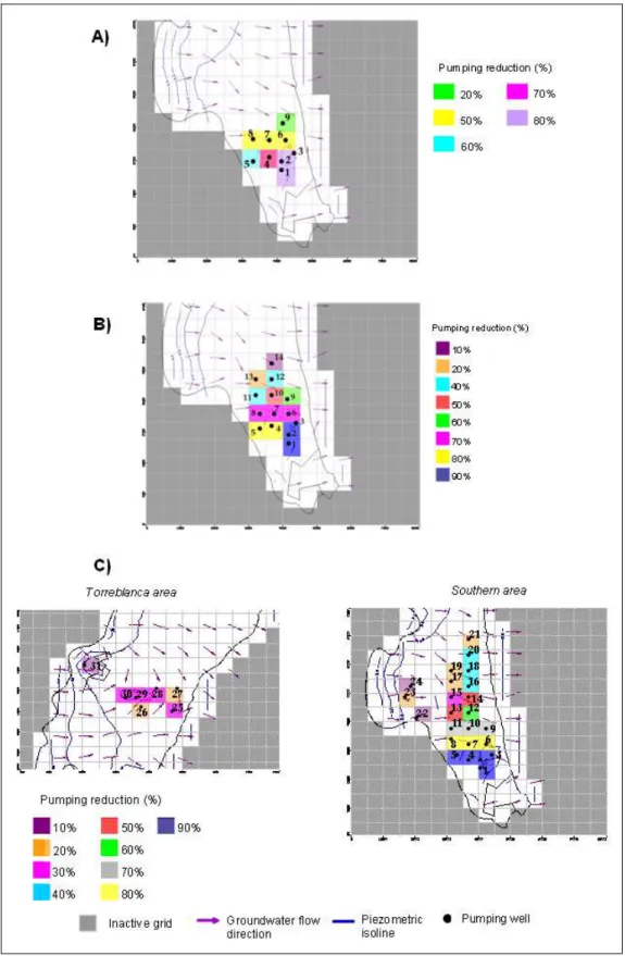
(9) The model used to calculate the PRANGS is a MODFLOW constant density groundwater flow model, executed under steady state conditions (IR model). PRANGS were calculated for humid (PRANGSh), intermediate (PRANGSi) and dry years (PRANGSd). The representative precipitation for each year type was obtained using rainfall data for the period 1973 and 2009 (www.ivia.es; González-Hidalgo 2010). The average rainfall corresponding to humid, intermediate and dry year are 884.6, 520.3, 337.5 mm/year respectively. We assume the next assumptions: - The pumping volume is the same as for the three reference models (IR model) proposed. - The irrigation returns are not modified. We assume that water resources from other origin are employed to cover the demand requirement although the reduction in pumping volume. Reduction in pumping volume to fulfill the marine intrusion constraint considers only water.. Phase 1: Sea-Aquifer interaction under natural and influenced regime The piezometric levels obtained when simulating the reference intrusion (NR model) in the three case studies are positive (above sea level) over the entire aquifer. Therefore, inflow from the sea to the aquifer are zero for humid, intermediate and dry years (see supplementary information in Figure S1).. Phases 2 (identification and delimitation of "critical intrusion areas" and their wells) and 3 (assessment of the pumping decrease required in each critical area to prevent intrusion problems, PRANGS) are applied successively for each reference condition (humid, intermediate and dry years).. Phase 2: Identification and delimitation of the "critical intrusion areas" and their wells - Humid year: The IRh simulation predicts that negative piezometric levels near the coast occur only in the so-called Southern sector. Therefore, the reduction of pumping required to fulfill the constraint of zero seawater intrusion into the aquifer is estimated for this critical area (see supplementary information Figure S2). In that case 8 wells, which pumped 4770 m3/day, are involved in the PRANGSh calculation. 9.
(10) -Intermediate year: In an intermediate year, the critical intrusion area is also in the Southern sector. The pumping reduction will be applied in 14 wells, which are located in the critical intrusion sector. 7420 m3 have been pumped by the wells involved in the PRANGSi calculation (see supplementary information Figure S3). - Dry year: In this case, there are two critical intrusion areas that are located in the Southern sector and the central Torreblanca sector (between the urban town of Torreblanca and the coast). In the Southern sector the pumping reach the 17421 m3/day, however in Torreblanca sector the pumping is lower, 3710 m3/day (see supplementary information Figure S4).. Phase 3: Assessment of the decrease in pumping required (in each critical area) to prevent intrusion. -Humid year: A balanced situation, in which the critical intrusion areas disappear, required five pumping reduction steps to be applied. Figure 3A summarizes the reductions in the pumped abstractions applied. The numerical information about the pumping reduction used in the PRANGSh calculation are detailed in the supplementary information, table S1. - Intermediate year: In order to achieve a positive piezometric level in the critical intrusion area, eight scenarios of reduced pumping were simulated. Figure 4A compares the piezometry of the IRi model with the last scenario performed (scenario 8). Figure 3B shows the wells and the percentage reduction in pumping simulated for scenario 8, while table S2 summarizes the reductions required to achieve the PRANGSi (see supplementary information). - Dry year: In order to reach positive piezometric levels in the Plain of Oropesa-Torreblanca, nine iterations needed to be simulated. In each scenario, the pumping volume was reduced by 10%. In the area called Torreblanca, there is no more seawater inflow (negative piezometric levels) near the coast after scenario 3; however, to reach that same situation in the southern area, a maximum reduction of 90% pumping was required in 5 wells (scenario 9 -last scenario) (Figure 3C y 4B). Figure 3C summarizes the reductions simulated in both areas to achieve the objective water quality. Detailed reductions applied to pumping volume in the areas affected by intrusion are shown both in supplementary information (Table S3 and S4). 10.
(11) Figure 3. Well location and reduction (%) used in the PRANGS calculation. A) PRANGSh. calculation. B) PRANGSi calculation. C) PRANGSd calculation. 11.
(12) A). B). IRi Model. Scenario 8. IRd model. Inactive grid. Scenario 3. Scenario 9. Groundwater flow direction Piezometric isoline. Dry cell. Areas affected by negative water table close to the coast. Figure 4. Piezometric level and groundwater direction in the IR model and Scenarios. A) IRi model and Scenarios 8 (PRANGSi). B) IRd model, scenarios 3 and 9 (PRANGSd). 12.
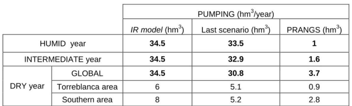
(13) Summarizing, the total pumping reduction required to define the Pumping Reduction to Achieve a Natural Good Status for a humid year (PRANGSh) is 1.0 hm3/year; for the intermediate year, PRANGSi is 1.6 hm3/year (Table 7), whilst for the dry year, PRANGSi is 3,7 hm3/year, distributed as 0.9 hm3/year in the Torreblanca area and 2.8 hm3/year in the Southern area (Table 2).. Table 2. PRANGS calculation. 3. PUMPING (hm /year) 3. 3. 3. IR model (hm ). Last scenario (hm ). PRANGS (hm ). HUMID year. 34.5. 33.5. 1. INTERMEDIATE year. 34.5. 32.9. 1.6. GLOBAL. 34.5. 30.8. 3.7. Torreblanca area. 6. 5.1. 0.9. Southern area. 8. 5.2. 2.8. DRY year. Limitations The use of constant density mathematical models to calculate PRANGS is justified by their greater simplicity and fewer data requirements data to create the model (Llopis-Albert and Pulido-Velazquez, 2014-2015). The use of variable density models would probably give more precise results but would increase the complexity of the methodology, and it must be remembered that the objective of this study is to define a clear and simple method that could help to establish management criteria for salinized coastal aquifers. Although numerical technique as Influence functions could be applied to solve these management optimization problems (see for example Pulido-Velazquez et al. 2008; Peña-Haro et al., 2010) we decide to apply a simple heuristic iterative procedure. We assume that working with a precision of 10% in pumping reductions is acceptable, given the existing uncertainties and simplifications assumed. Another advantage of the proposed iterative procedure is that it allows the solution to be explained graphically. Other future scenarios could also be analyzed taking into account the influence of climate change on the aquifer recharge (Pulido-Velazquez et al. 2015; Molina et al., 2013; Colombani et al., 2016),. Conclusions and final considerations. 13.
(14) We propose a methodology to assess the Pumping Reduction to Achieve a Natural Good Status (PRANGS) required to avoid seawater intrusion problems, defined as the minimum reduction in the pumped abstraction volume from an aquifer unit required to keep seawater intrusion below the value estimated for the natural regime. The PRANGS was defined separately for conditions representative of humid (PRANGSh), intermediate (PRANGSi), and dry years (PRANGSd). The problem requires an optimization problem to be solved (for representative humid, intermediate and dry conditions), whose objective function is to minimize the reduction in pumping required whilst fulfilling the constraint of not increasing intrusion above the natural regime. The problem was solved using an iterative process, from a constant density flow simulation model of the aquifer, assuming a direct relationship between piezometric drawdown and seawater intrusion. The method was applied to a Spanish Mediterranean aquifer, the Oropesa-Torreblanca Plain, which is well-known as an intensively exploited aquifer (Morell and Giménez, 1997). The piezometric level under a natural regime was analyzed for humid (NRh model), intermediate (NRi model) and dry years (NRd model). Under these three natural scenarios, piezometric levels remain above the sea level and so seawater inflow into the aquifer can be considered to be negligible. We then simulated the current pumping regime (IR model). This shows freshwater aquifer levels below sea level, which is a situation associated with seawater inflows and the advance of marine intrusion (negative piezometric levels) as a direct result of the pumped abstractions. The PRANGS for humid (PRANGSh), intermediate (PRANGSi) and dry years (PRANGSd) was calculated. In all three cases, the PRANGS requires pumping to be educed in the Southern sector. In dry years, pumping reductions are also required, though to a lesser extent, in the central Torreblanca sector. As expected, in dry years the PRANGSd (3.7 hm3/year) is the highest of the three calculated. In this case, the pumping reduction required (PRANGSd) is 3.5 times greater than in the least restrictive case, i.e. the humid year (1.0 hm3/year). The PRANGSi calculated for the intermediate year is 1.6 hm3/year. In dry years, two critical intrusion areas are identified: the Southern and central Torreblanca sectors. The PRANGSd in the area of Torreblanca (0.9 hm3/year) is a third of that in the Southern area (2.8 hm3/year), where pumping is more intensive. With regards to resource management, we propose that the PRANGSd be calculated as a first approximation. It represents, in any case, the maximum restriction required to guarantee a discharge of groundwater to the sea that is sufficient to impede the ingress of. 14.
(15) seawater and maintain the sustainability of the groundwater resources. Alternatively, the reduction corresponding to the PRANGSi could be applied, with use of greater restrictions (PRANGSd) in the case of abnormally dry periods. Following these recommendations, it is proposed that, in the case of the OropesaTorreblanca Plain, the maximum restriction should be applied – the PRANGSd corresponding to 2.8 hm3/year in the Southern area and 0.9 hm3/year in the Torreblanca area. In the case of applying the reduction corresponding to the PRANGSi, the Southern area reduction would be 1.6 hm3/year but, during dry periods, the restrictions corresponding to the PRANGSd would be used.. Acknowledgments This research was partially supported by the GESINHIMPADAPT project (CGL2013-48424-C22-R) with Spanish MINECO funds.. References Arslan H, Demir Y (2013) Impacts of seawater intrusion on soil salinity and alkalinity in Bafra Plain, Turkey. Environmental Monitoring and Assessment 185 (2): 1027-1040 Ataie-Asthtiani, Betabchi H (2011) Elitist continuous ant colony optimization algorithm for optima management of coastal aquifers. Water Resources Management 25: 165-190. doi: 10.1007/s11269-101-9693-x Bellot J, Bonet A, Pena J,Sanches JR (2007). Human impacts on land cover and water balances in coastal Mediterranean country. Environmental management 39(3): 412-422. doi: 10.1007/s00267-005-0317-9 Bobba G (1993) Mathematical models for saltwater intrusion in coastal aquifers. Water Resources Management 7(1): 3-37 Colombani N, Osti A, Volta G, Mastrocicco, M (2016) Impact of Climate Change on Salinization of Coastal Water Resources. Water Resources Management 30(7): 2483-2496 Custodio E (2010) Coastal Aquifers of Europe: an overview. Hydrogeological Journal . doi: 10.1007/s10040-009-0496-1 Daniele L,Vallejos A, Sola F (2011) Hydrogeochemical processes in the vicinity of a desalination plant (Cabo de Gata, SE Spain). Desalination 277 (1-3): 338-347 Dhar A and Datta B (2009) Saltwater Intrusion Management of Coastal Aquifers. II: Operation Uncertainty and Monitoring. Journal of Hydrologic Engineering 14(12):1273– 1282 Don NC, Hang NTM, Ariki H, Yamanishi H, Koga K (2006) Groundwater resources and management for paddy field irrigation and associated environmental problems in an alluvial coastal lowland plain. Agricultural Water Management 84(3): 295-304. doi: 10.1016/j.agwat.2006.03.006. 15.
(16) Doulgeris C, Zissis T (2014) 3D variable density flow simultaion to evaluate dumping schemes in coastal aquifers. Water Resources Management 28 (14): 4943-4956 El-Kadi AI, TIllery S, Whittier RB, Hagedorn B, Mair A, Ha K, Koh GW (2014) Assessing sustainability of grundwater resources on Jeju Island, South Korea, under climate change, drought and increase usage. Hydrogeology Journal 22 (3):625-642. doi:10.1007/s1000400013-1084-y European Union-Water Framerwork Directive (EU-WFD, 2000) “Directiva 2000 / 60 / CE del Parlamento Europeo y del Consejo de 23 de Octubre de 2000”. Diario Oficial de las Comunidades Europeas de 22/12/2000. L 327/1-327/32 Ferreira da Silva JF, Haie N (2007) Optimal locations of groundwater extractions in coastal aquifer. Water Resources Management 21: 1299-1311. doi: 10.1007/s11269-006-9082-7 Fujinawa K (2011) Anthroscape of Mediterranean coastal area in the context of hydrogeology: Projected impacts of climate change. Sustainable Land Management. Pp:311-332. doi: 10.1007/978-3-642-14782-1_14 González–Hidalgo JC, Brunetti M, de Luis M (2010) A new tool for monthly precipitation analysis in Spain: MOPREDAS database (Monthly precipitation trends December 1945November 2005). International Journal of Climatology 31(5): 715-731. doi: 10.1002/joc. 2115 Grundmann J, Schutze N, Schmitz GH (2012) Towards an integrated arid zone water management using simulation- based optimisation. Environmental Earth Sciences 65 (3):138-1394. doi 10.1007/s12665-011-1253-z Hugman R, Stigter TY, Monteiro JP, Costa J, Nunes LM (2015) Modelling the spatial and temporal distribution of coastal grundwater discharge for different water use scenarios under epistemic uncertainty: case study in South Portugal. Environmental Earth Sciences 73 (6): 2657-2669. doi: 10.1007/s12665-014-3709-4 Indset M, Stokke KB (2015) Layering, administrative change and national path to europeanizaton: The case of the Water Framework Directive. European Planning Studies 23 (5): 979-998 pp. DOI: 10.1080/09654313.2014.915014 Iríbar V, Carrera J, Custodio E, Medina A (1997) Inverse modeling of seawater intrusion in the Llobregat delta deep aquifer. Journal of Hydrology 44: 198-226 Instituto Valenciano de Investigaciones Agrarias-Valencia Institute for Agricultural Research-(IVIA) http://riegos.ivia.es/ Kaman H, Kurunc A, Sonmez NK, Cetin M, Us BY, Aslan GE (2011) Preliminary investigation of seawater intrusion into inland through Acisu Creek in Antalya, Turkey. Journal of Food Agriculture and Environment 9 (2): 612-617. Khublaryan MG, Frolov AP, Yushmanov IO (2008) Seawater intrusion into coastal aquifers. Water Resources 35(3):274-286. doi: 10.1134/S0097807808030032 Liu CH, Chou YL, Lin ST, Lin GJ, Jang CS (2010) Management of high groundwater level aquifer in the Taipei Basin. Water Resources Management 24 (13): 3513-3525. DOI 10.1007/s11269-010-9617-9. 16.
(17) Liu CCK, Dai JJ (2012) Seawater intrusion and sustainable yield of basal aquifers. Journal of the American Water Resources Assotiation 48(5): 861-870. doi: 10.1111/j.17521688.2012.00659.x. Llopis-Albert C. Pulido-Velazquez D (2014) Discussion about the validity of sharp-interface models to deal with seawater intrusion in coastal aquifers. Hydrological Process 28: 3642– 3654. doi: 10.1002/hyp.9908 Llopis-Albert C, Pulido-Velazquez D (2015) Using MODFLOW code to approach transient hydraulic head with a sharp-interface solution. Hydrological Process 29(8):2052–2064. doi: 10.1002/hyp.10354 March H, Sauri D, Olcina J (2014). Trising temperatures and dwilidling water supplies? Perception of climate change Among residents of the spanish Mediterranean tourist coastal areas. Environmental Management 53(1): 181-193. doi: 10.1007/s00267-013-0177-7 Mays LW (2013) Groundwater Resources Sustainability: Past, present and future. Water Resources Management 27(17): 4409-4424 McCoy CA, Corbett CR (2009) Review of submarine groundwater discharge (SGD) in coastalzones of the Southeast and Gulf Coast regions of the Unitated States with Management implications. Journal of Environmental Management 90 (1):644-651. doi: 10.1016/j.jenvman.2008.03.002 Molina JL, Pulido-Velazquez D., García-Aróstegui JL, Pulido-Velázquez M (2013) Dynamic Bayesian Networks as a Decision Support tool for assessing Climate Change impacts on highly stressed groundwater systems. Journal of Hydrology 479 (2013) 113–129. http://dx.doi.org/10.1016/j.jhydrol.2012.11.038.. Morell I, Giménez E (1997) Hydrogeochemiccal analysis of salinization processes in the coastal aquifer of Oropesa (Castellón, Spain). Environmental Geology 29 (1/2):118-131. doi: 10.1007/s002540050110 Naji A, Cheng AD, Quazar D (1999) BEM solution of stochastic seawater intrusión problems. Engineering Anaysis with Boundary Elements 23 (7): 529-537. doi: 10.1016/S0955-7997(99)00012-0 Nettasana T, Craig J, Tolson B (2012) Conceptual and numerical models for sustainable groundwater Management in the Thaphra area, Chi River Basin, Thailand. Hydrogeology Journal 20(7): 1355-1374. doi: 10.1007/s10040-012-0887-6 Peña-Haro S, Llopis-Albert C, Pulido-Velazquez M, Pulido-Velazquez D (2010) Fertilizer standards for controlling groundwater nitrate pollution from agriculture: El Salobral-Los Llanos case study, Spain. Journal of Hydrology 392 (2010):174–187. doi: 10.1016/j.jhydrol.2010.08.006 Peralta R, Timani B, Das R (2011) Optimizing safe yield policy implementation. Water Resources Management 25: 483-508. doi: 10.1007/s11269-010-9710-0 Psarropoulou ET, Karatzas GP (2012) Transient groundwater modelling with spatiotemporally variable fluxes in complex aquifer systems: new approach in defining boundary conditions for transient flow model. Civil Engineering and environmental systems 29(1): 1 – 21. doi: 10.1080/10286608.2011.637622 Pulido-Leboeuf P, Pulido-Bosch A, Calvache ML (2003) Strontium, SO42-/Cl- and Mg2+/Ca2+ ratios as tracers for the evolution of seawater into coastal aquifers: the. 17.
(18) example of Castell de Ferro aquifer (SE Spain). Comptes Rendus Geoscience 335 (14): 1039-1048 Pulido-Velazquez D, Ahlfeld D. Andreu J, Sahuquillo A. (2008) Reducing the computational cost of unconfined groundwater flow in conjunctive-use models at basin scale assuming linear behaviour: The case of Adra- Campo de Dalías. Journal of Hydrology 353(1-2): 159– 174. doi:10.1016/j.jhydrol.2008.02.006 Pulido-Velazquez D, García-Aróstegui JL, Molina JL, Pulido-Velazquez M (2015) Assessment of future groundwater recharge in semi-arid regions under climate change scenarios (Serral-Salinas aquifer, SE Spain). Could increased rainfall variability increase the recharge rate? Hydrol. Process 29(6):828-844. doi: 10.1002/hyp.10191 Rejani R, Jha MK, Panda SN, Mull R (2008) Simulation modelling for efficient groundwater management in Balasore coastal basin, India. Water Resources Management 22 (1): 23 50. doi: 10.1007/s11269-006-9142-z Rejani R, Jha MK, Panda SN (2009) Simulation-optimization modelling for sustainable groundwater management in a coastal basin of Orissa, India. Water Resources Management Vol 23 (2): 235-263. doi: 10.1007/s11269-008-9273-5 Rodriguez-Estrella T, Pulido–Bosch A (2009) Methodologies for abstraction from coastal aquifers for supplying desalination plants in the south-east of Spain. Desalination 249 (3): 1088-1098. doi: 10.1016/j.desal.2009.06.046 Robins NS, Jones HK, Ellis J (1999) An aquifer management case study-The Chalk of english South Downs. Water Resources Management 13(3): 205-218. doi: 10.1023/A:1008101727356. Rosenthal E, Vinokurov A, Ronen D, Magaritza M, Moshkovitz S (1992) Anthopogenically induced salinization of groundwater –A case-study from the coastal-Plain Aquifer of Israel. Journal of Contaminant Hydrology 11 (1-2): 149-171. doi: 10.1016/0169-7722(92)90038-G Salcedo–Sánchez ER, Esteller MV, Garrido SE, Martínez-Morales M (2012) Groundwater optimization modelo for sustainable Management of the valley of Puebla aquifer, Mexico. Environmental Earth Sciences 73:337-351. doi:10.1007/s12665-012-2131-z Santos FD, Stigter TY, Faysse N, Lourenc TC (2014) Impacts and adaptation to climate change in the Mediterranean coastal areas: The CIRCLE-MED initiative. Regional Environmental Change 14 (Suppl 1): S1-S3. doi: 10.1007/s10113-013-0551-2 Senent-Aparicio J, Pérez-Sánchez J, García-Aróstegui JL, Bielsa-Artero A, DomingoPinillos JC (2015) Evaluating Groundwater Management Sustainability under Limited Data Availability in Semiarid Zones. Water 7(8): 4305-4322. doi:10.3390/w7084305 Shammas MI, Thunvik R (2009). Predictive simulation of flow and solute transport for managing the Salalah coastal aquifer, Oman. Water Resources Management 23 (14): 25941-2963 Sola F, Vallejos A, Moreno L, López-Geta JA, Pulido-Bosch A (2013) Identification of hydrogeochemical process linked to marine intrusion induced by pumping of a semiconfined Mediterranean coastal aquifer. International Journal of Environmental Science and Technology 10(1): 63-76. doi: 10.1007/s13762-012-0087-x Sreekanth J, Datta B (2010) Multi-objective management of saltwater intrusion in coastal aquifers using genetic programming and modular neural network based surrogate models. Journal of hydrology 393: 245-256. doi: 10.1016/j.jhydrol.2010.08.023. 18.
(19) Sreekanth J, Datta B ( 2011) Comparative evaluation of genetic programming and neural network as potential surrogate models for coastal aquifer management. Water Resources Management 25: 3201-3218. doi: 10.1007/s11269-011-9852-8 Unsal B,Yagbasan O,Yazicigil H (2014) Assessing the impacts of climate change on suitainable management of coastal aquifers. Environmental Earth Sciences.72 (6): 21832193. doi: 10.1007/s12665-014-3130-z Uddameri V, Hernandez EA, Singaraju S (2014) A successive steady-state model for simulating freshwater discharges and saltwater wedge profiles at Baffin Bay, Texas. Environmental Earth Sciences 71 (6):2535-2546. doi: 10.1007/s12665-013-2898-6 Vallejos A, Sola F, Pulido-Bosch A (2015) Processes Influencing Groundwater Level and the Freshwater-Saltwater Interface in a Coastal Aquifer. Water Resour Manage 29: 679 – 697. doi 10.1007/s11269-014-0621-3 Werner AD, Bakker M, Post VEA, Vandenbohede A, Lu CH, Ataie-Ashtiani B, Simmons CT, Barry DA (2013) Seawater intrusion processes, investigation and management: Recent advances and future challenges. Advances in Water Resources 51: 3-26. doi: doi:10.1016/j.advwatres.2012.03.004 Willaarts BA, Ballesteros M, Hernandez-Mora N (2014) Ten years of the Water Framework Directive in Spain: An overviewof the ecological and chemical status of surface water bodies. Ontegrates Water Resources Management in the 21th Century: Revising the Paradigm. 6Th Botin Water Workshop. CRC Press. ISBN: 978-1-138-00143-5 Yechieli Y, Sivan O (2011) The distribution of saline groundwater and its relation to the hydraulic conditions of aquifers and aquitards: example from Israel. Hydrogeology Journal 19 (1):71-87 Zhou X (2014) Determination of the distance of the fresh water-salt water interface extending into coastal confined aquifers. Environmental Earthe Sciences 71: 1311-1317. doi: 10.1007/s12665-013-2537-2 Zouahri A, Dakak H, Douaik A, El Khadir M, Moussadek R (2015) Evaluation of groundwater suitability for irrigation in the Skhirat region, Northwest of Morrocco. Environmental Monitoring and Assessment 187(1): 4184. doi: 10.1007/s10661-014-4184-9. 19.
(20)
Figure

+3

Documento similar