1
El Niño – La Niña – Neutral Conditions
2 - Year Prediction
June 2017 into June 2019
Issued 15 April 2017
Next Issuance 15 June 2017
Forecast is not for mass dissemination without express written consent
by GWO
Global Weather Oscillations Inc.
4423 SE 14
thStreet
Ocala, Florida 34471 USA
www.GlobalWeatherOscillations.com
Tel: 1-352-732-8170
Email: [email protected]
Global Weather Oscillations Inc.
(GWO)
Specializing in
Climate Cycle Predictions
2
1.
What is an El Niño or La Niña
Oscillating changes in ocean temperatures and climate patterns across the tropical Pacific Ocean occurs on the average of every 3 to 5 years, with these changes greatly influencing regional weather patterns around the world. The oscillations of the Pacific Ocean and associated weather fluctuations have several names, such as; ENSO which stands for the El Niño Southern Oscillation, or the more common terminology - "El Niño" and "La Niña" oscillation. The oscillations of the tropical South Pacific Ocean actually refers to; variations in the temperature of the
Pacific Ocean water temperature across the tropical eastern Pacific Ocean (figure 1), with these oscillations influencing rapid and often very pronounced changes in the climate for up to one year, or in some cases up to 2-years, such as the case with the strong La Niña during the years 2010 through 2011.
About every 4 years, rapid warming of the tropical Eastern Pacific Ocean evolves into what we call a "Mature Warm Phase", or better known as an El Niño. When this occurs; dominant high pressure and dry conditions over the eastern Pacific are displaced, and replaced with low pressure with stormy weather being more dominant. This abrupt change in the eastern Pacific climate pattern then alters the weather pattern across North America, South America and much of the northern hemisphere. El Niño is Spanish for "the little boy" and refers to the Christ child, because periodic warming in thePacific near South America is usually noticed around Christmas.
During the "Mature Cold La Niña Phase", which is the opposite of the El Niño oscillation, stronger than normal high pressure dominates the eastern Pacific. The strong area of high pressure and colder eastern Pacific Ocean water temperatures alter the weather patterns around the northern hemisphere, but with different weather patterns than the El Niño. Both the La Niña and the El Niño phases cause stubborn and often dangerous weather patterns, with areas around the world experiencing extreme weather patterns, thus causing extreme weather such as flood or droughts, cold or warmth.
2.
Monitoring
3 Organizations monitor what is known as the Nino 4 and Nino 3.4 region in the Tropical Central South Pacific for the onset of an El Niño (figure - 2 blue circle). The Nino 4 region in the west-central equatorial Pacific Ocean is normally warm during the Neutral Condition phase and cool during the La Niña phase. During the La Niña phase, the Nino 3.4 ocean water is normally cold due to upwelling that brings colder water from the subsurface to the surface. This region then warms rapidly during the onset of an El Niño, and if sustained warming occurs, the warming will cause the Mature Phase of a Warm ENSO event (El Niño) (see Figure 2 below). Once it becomes mature the warm will spread further east to the South American coastal areas.
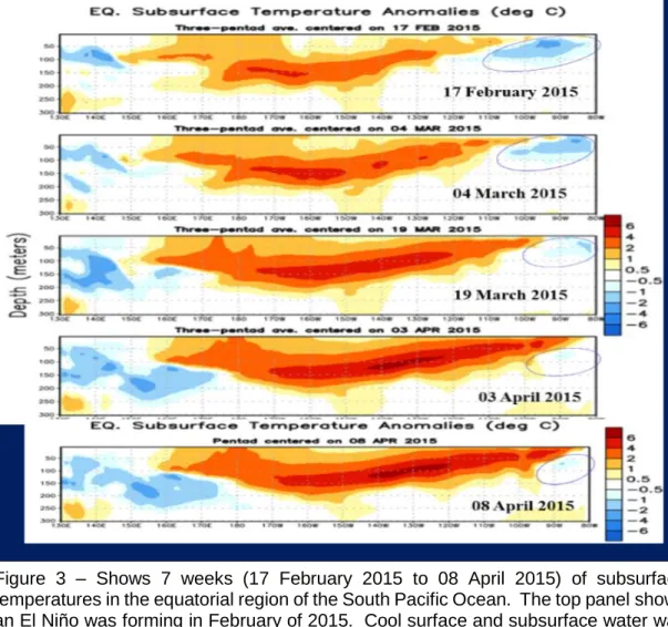
The 2015-2016 El Niño formed in the eastern portion of the Niño 4 region (see Pacific Subsurface ocean temperatures in figure 3) and in the western portion of the Nino 3.4 Region in May 2016 and became a strong El Niño by July. An El Niño typically forms in the Nino 3.4 region, and then propagates east to the South American Coast following a shift in surface winds. But for this to happen, the Pacific High Pressure center must become displaced, with this followed by a burst of wind that changes the surface wind direction off South America. This wind change burst then changes the cold upwelling of water to down welling and allows the warm water in the Nino 3.4 region to move rapidly east to the coastal areas.
It can be seen in Figure 3 (top panel below) that an El Niño was forming in February of 2015. Cool surface and subsurface water was along the South American Coastline - and very warm (red and dark red) warm water in the Central Tropical Pacific propagating eastward. The bottom panel shows that the subsurface water had moved
4 east all the way to the South American Coast by April 2015 – thus signaling the
beginning of the 2015-16 strong El Niño. This same scenario will take place during the period September to October of 2017.
3. Current Conditions
April 2017 - see GWO’s web site for more current conditions
Neutral Conditions
The subsurface and surface ocean temperatures (Figures 4 and 5) indicate that as of 05 April 2017, Neutral ENSO conditions are still firmly in place.
5
In Figures 4 and 5 above, warmer than normal subsurface water has remained
unchanged in the Western Pacific – but is increasing in the extreme Eastern Pacific. But at the same time colder than normal subsurface water is intensifying in the Central Pacific. This likely means that an El Nino is still far into the future – near October instead of July or August as many other organizations are suggesting.
4. Predictions: June 2017 into June 2019
Neutral Conditions June 2017 into September 2017 El Niño Conditions October 2018 into September 2018 Neutral Conditions October 2018 into March 2019 La Nina Conditions June 2019
6 Prediction Discussion: Figures 4 and 5 above indicate that the warmer than normal subsurface water has remained unchanged in the Western Pacific – but is increasing in the extreme Eastern Pacific. However, colder than normal subsurface water is
intensifying in the Central Pacific. This likely means that an El Niño is still far into the future – near October instead of July or August as many other organizations are suggesting.
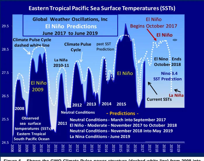
GWO’s Climate Pulse prediction model (see figure 6 below) shows the Climate Pulse prediction for the Nino 3.4 region where El Niño events form - and where they end. The white dashed line in Figure 6 is the Climate Pulse Power Structure from 2008 into April of 2017 – notice that the sea surface temperatures in the Niño 3.4 region follow the power structure of the Climate Pulse.
20
08 2008 2009 2009 2010 2010 2011 2011 2012 2012 2013 2013 2014 2014 2015 2015 2016 2016 2017 2017 2018 2018 2019 2019
24.5 25.5 26.5 27.5 28.5 29.5
Eastern Tropical Pacific Sea Surface Temperatures (SSTs)
Global Weather Oscillations, Inc
El Niño Predictions
June 2017 to June 2019Climate Pulse Cycle Climate Pulse Cycle
dashed white line
Observed sea surface temperatures (SSTs)
Eastern Tropical South Pacific Ocean
El Niño 2009 La Niña 2010-11 2008 2011 El Niño Begins October 2017
-
Predictions-Neutral Conditions - March into September 2017 El Niño - Moderate - November 2017 to October 2018 Neutral Conditions - November 2018 into May 2019 La Nina Conditions - June 2019
2012 2013 2014
Neutral Conditions
2015
Nino 3.4 SST Prediction
El Niño
El Nino - Ends October 2018 past SST Prediction Current SSTs El Niño La Niña
7 The heavier dashed white line from June 2017 into June 2019 is the Climate Pulse power structure and the GWO prediction for the ocean temperatures in the Nino 3.4 Region west of the Tropical South American Coast – this is where the El Niño forms and where it demises (see Figure 2).
As seen in the prediction in Figure 6 above, the sub-surface ocean temperatures in the Equatorial Tropical South Pacific Nino 3.4 region where El Nino events form – will be warming during the period from June 2017 through October 2017. El Niño Southern Oscillations (ENSO) and weather condition patterns will be what is called Neutral
Conditions (neither El Niño nor La Niña Conditions) from June 2017 into late September or October 2017. This is called “ENSO Neutral” and weather patterns around the world should not have either La Nina nor El Nino abnormalities.
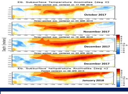
The graphic panels (top to bottom) in Figure 7 show the formation of the 2015 El Niño – the same scenario will likely take place from August 2017 into October 2017 as the upcoming El Niño forms.
The Tropical South Pacific Ocean water
temperatures in both the subsurface layers and on the surface, will continue warming from August into October of 2017. By July of 2017, the Tropical South Pacific
subsurface temperatures should resemble the top panel in Figure 7, with warm subsurface water developing across the Central Tropical Pacific and a cold pool of water remaining from the La
Niña in the Eastern Pacific near South America. The pool of warm subsurface water will then spread east to the South American Coast during September and October 2017. Then what is called upwelling will bring the warm water to the surface and begin the moderate El Niño that will last into September of 2018.
With a moderate El Niño developing toward the end of September to October. El Niño conditions will then continue from October-November of 2017 to September – October of 2018. The El Niño will transition to Neutral Conditions around October of 2018 and be well in place by November 2018 and continue into March of 2019. A Liña will likely develop around June of 2019.
Figure 7 – Shows typical development of the 2015 El Niño. The Equatorial Tropical South Pacific subsurface water warmed in the Central South Pacific and then during the next 7 weeks moved east to the South American coast – beginning the 2015 El Niño.
8
Typical Conditions – Globally
June 2017 into June 2019
Atmospheric patterns and weather conditions will be influenced by ENSO Neutral Conditions until mid-September or October of 2017 – with patterns typically following normal weather patterns. Although some areas in Western areas of South America may experience untypical weather resembling what occurs during El Niño conditions, but this will likely fade out by about June and then begin again as the El Niño begins.
Then typical anomalous weather patterns and conditions associated with El Niño events will take hold in October or November of 2017– and continue into about
September of 2018. More normal atmospheric patterns and weather conditions will once again return under the influence of ENSO Neutral conditions (neither El Niño nor La Niña conditions) around September to October of 2018. The ENSO Neutral conditions will then continue into March of 2019 and transition to La Niña conditions around June of 2019.
The onset of the El Niño will cause wide disparities in temperatures and precipitation around the world during the period from October 2017 to September 2018. Some localities will be very cold, some very warm, some wet and some dry. The onset
of Global Cooling will begin to be realized in some regions during the winter of 2017 –
and then spread to most regions once the El Nino dissipates in September-October of 2018.
For the most part, more normal weather typical to the 1950s through the 1970s should occur in most regions of the world from January 2019 and beyond as regional temperatures continue cooling with the next global cooling cycle. This cycle will last for at least 50 years.
Please refer to the section below for more information regarding regions.
North America
– Greenland – British Isles - Russia – Germany -
Southward
June 2017 to Late September or October 2018
9 October of 2017 – with patterns typically following normal weather patterns – but with a strong Atlantic Basin hurricane season.
October 2017 to September 2018
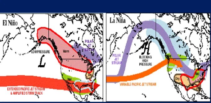
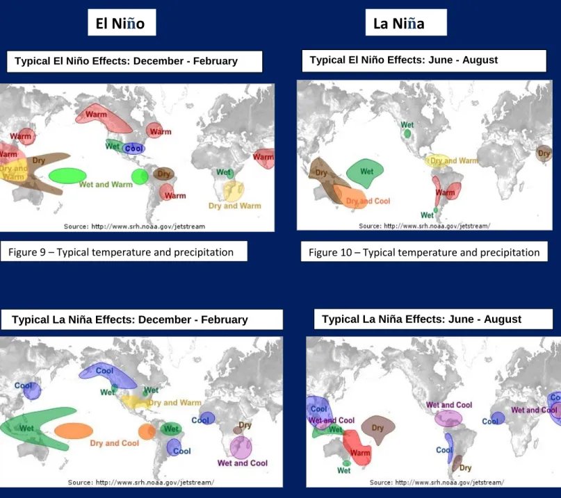
ENSO Neutral Conditions will transition to moderate El Niño conditions during the period from late-September and October 2017. Moderate El Niño conditions will then continue to about September of 2018. Typical anomalous weather patterns and conditions associated with El Niño events will take hold in October and November of 2017 (see graphics in Figure 8 below for typical El Niño patterns).
Expect a mild winter across the northern tier states of the United States all the way into Southwestern Canada and Southern Alaska. Very wet on the west coast of the United states, floods in California and Oregon. Stormy in the central and northeastern United States – but many storms will be snow changing to rain in the northeast, but heavy snow likely in some corridors and especially near the Canadian border in the Central United States. There will be some areas with big storms an unexpected blizzard (although the snow will melt rapidly following the storm). Some areas will have flooding due to the El Nino. Expect tornado activity and cool weather in the southeastern United States January to March.
Southern Greenland will be milder as will Russia during the 2018 winter. The British Isles will be cold and snowy, a winter to remember - somewhat reminiscent of the
10 2009-10 El Niño. Expect some of the cold and snow to make it to the region around Germany.
September 2018 to May 2019
ENSO (El Niño Southern Oscillation) Neutral Conditions for the period from September 2018 into May 2019. More normal weather patterns – or in other words neither an El Niño nor La Niña pattern. Basically, more normal atmospheric patterns and weather conditions will once again.
Much colder winter most of the United States except mild in the Southeast and West Coast. Much colder winter across all of Alaska– Canada – Greenland and Europe into Asia. Global cooling will come in with a vengeance during the 2018-19 winter, and especially following the 2019 winter. Alaska – Canada – Greenland and Europe will be cold and getting colder. Severe Arctic Polar Vortex outbreaks for much of the region. Snowy winter in the eastern United States – very cold in Greenland, Russia – cold and snowy in the British Isles.
June 2019 – La Niña
La Nina conditions will begin in June of 2019 – see Figures 10 and 12.
2019 and Beyond - Global Cooling Cycle Beginning in Earnest
It should also be kept in mind that the global climate pattern is now transitioning from a global warming cycle (2000 through 2013) to a global cooling long-term cycle. Both the Arctic and Antarctic entered the next global cooling cycle 4 years ago, and have been cooling since 2013 – except for a warming interruption caused by the El Niño in 2015-16 and the El Nino of 2017-18. Due to the El Niño, sea ice in the western Arctic near Alaska and Euro-Straights region near Iceland diminished with the strong warm El Niño during late 2015 into 2016, and will also diminish some with the 2017-18 El Niño – but it will once again begin freezing more solid and grow rapidly in extent from the 2019 winter and beyond.
The Arctic ice extent grew rapidly from 2011 through 2014 but then diminished in 2015-16 due to the El Niño and the strong Pacific High that caused the California
drought. The Pacific High finally weakened in 2017 and once the 2017-18 El Niño end – The Arctic will enter a prolonged cooling trend with major restoration of sea ice. The sea ice in the western Arctic near Alaska and Euro-Straights region near Iceland has diminished during late 2015 into 2016, but has will begin restoring rapidly following the end of the 2018 El Niño.
11
South America – Southern Asia – Australia
June 2017 into September 2017
(see graphics below for typical El Niño patterns)
Atmospheric patterns and weather conditions will be influenced by what is called ENSO Neutral Conditions (neither El Niño nor La Niña conditions) until late September or October of 2017 – with patterns typically following normal weather patterns.
October 2017 to September 2018
ENSO Neutral Conditions will transition to moderate El Niño conditions during October 2017 and continue to about September of 2018. Typical anomalous weather patterns and conditions associated with El Niño events (see graphics below) will take hold in October and November of 2017.
Typically – it will be warm in the Tropical Southwest Pacific Region, dry and warm in the region of Indonesia – dry across Northern Australia. It will be wet across Northwestern South America and dry in the Northeastern South America Region. Central South America will be warm, some of the region will have above normal precipitation. Southeastern Africa will be warm and dry.
September 2018 to March 2019
The El Niño will transition to ENSO (El Niño Southern Oscillation) Neutral Conditions for the period from September 2018 into March 2019. More normal weather patterns – or in other words neither an El Niño nor La Niña pattern. Basically, more normal
atmospheric patterns and weather conditions will once again.
June 2019 – La Niña
(see typical La Niña conditions in Figure 12 below)
The Onset of Global Cooling will begin to be realized in many regions, severe cold will occur in some regions following the 2017-18 El Niño. The global climate pattern is now transitioning from a global warming cycle (2000 through 2016) to a global cooling long-term cycle. Both the Arctic and Antarctic entered the next global cooling cycle 4 years ago, and have been cooling since 2013 – except for a warming interruption caused by the El Niño in 2015 and the El Nino of 2017-18. Due to the El Niño, sea ice deteriorated during the last El Niño, and will again during the 2017-18 El Niño. The Antarctic sea ice and glaciers once again begin freezing more solid and grow rapidly in extent from the 2019 winter and beyond.
12
El Ni
ñ
o
La Ni
ñ
a
Typical El Niño Effects: December - February
Typical La Niña Effects: December - February Typical La Niña Effects: June - August
Figure 11 – Typical temperature and precipitation
Typical El Niño Effects: June - August