Structural analysis of the Louisburgh-Clare island
succession, Co. Mayo, Ireland
G. C
ASINI1, 3*ANDP. D. R
YAN21Dipartimento di Scienze della Terra, Università degli Studi di Siena, Italy.
2Department of Earth and Ocean Sciences, NUI, Galway, Ireland.
3Now at: Institute of Earth Science ‘Jaume Almera’, CSIC, Barcelona, Spain.
*e-mail: [email protected]
Abstract: The Late Silurian Louisburgh-Clare Island Succession, south Co. Mayo, Ireland, is located along the Irish tract of the Highland Boundary Fault. This lineament originated in Ordovician times and was reactivated during Late Silurian-Middle Devonian times. Detailed structural analysis of the succession in the section between Turlin Strand and Shlivagh Rocks, south Clew Bay, was performed in order to determine the style and timing of deformation of the Silurian basin. The Louisburgh-Clare Island Succession recorded N-S contraction overprinted by roughly E-W oblique deformations. N-S contraction of the basin probably began before the end of Silurian deposition during pure shear dom-inated transpressional deformation and was replaced by dominant E-W transtensional deformation in Early/Middle Devonian time.
Keywords:Silurian, N-S shortening, transtension, Caledonides, Ireland.
Clew Bay, Co. Mayo, Ireland, is crossed from east to west by the Clew Bay Fault Zone which is part of one of the main tectonic lineaments of Ireland, the Highland Boundary Fault (Fig. 1). This lineament originated during collision between an Ordovician volcanic arc and the southern passive margin of Laurentia in Ordovician times (Dewey and Ryan, 1990 and references therein) and recorded important reactivation in Late Silurian-Devonian times as a con-sequence of Laurentia-Avalonia collision and final closure of the Iapetus Ocean (Soper et al., 1992 and references therein).
The Late Silurian non-metamorphic Louisburgh-Clare Island Succession consists of littoral to non-marine deposits exposed along the south coast of Clew Bay and Clare Island (Phillips et al., 1970; Phillips, 1974). The north dipping Emlagh Fault
sep-arate the succession, Ludlow-Pridoli in age, from underlying metamorphic rocks of the Clew Bay Supercomplex (Ordovician accretionary complex), to the east, and the Silurian greenschist facies Croagh Patrick Succession, to the south (Fig. 1b).
Clew Bay, was carried out to investigate timing and style of deformation of the Silurian basin during Caledonian reactivation of the Clew Bay Fault Zone.
Structural record
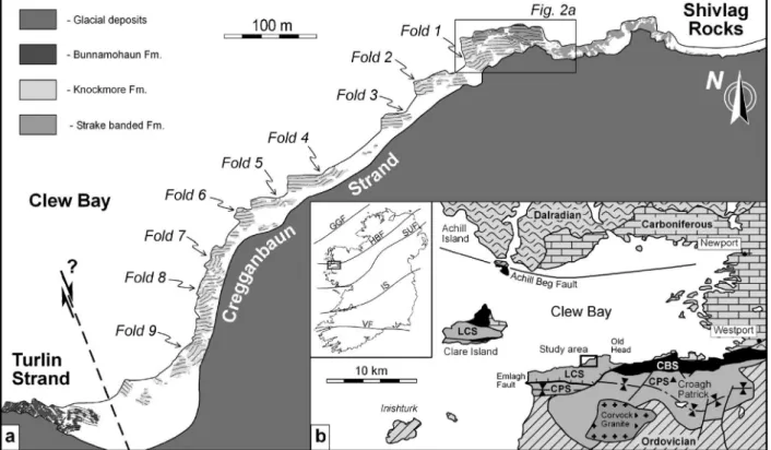
The study area is located along the southern shore of Clew Bay, between Turlin Strand and Shivlagh Rocks, south Co. Mayo, NW Ireland (Fig. 1). In this section, Silurian rocks belonging to the Louisburgh-Clare Island Succession are exposed in erosional surfaces between the high and low tide sea level marks. Detailed structural mapping, carried out subdividing the rock outcrops into rectangular grids, shows that, along the whole section, strata are in general nearly vertical with an overall E-W trend (Fig. 2b-i). The orientation of bedding is related to regional scale E-W folding. The whole study area is located on the north-ern limb of a kilometric-scale syncline.
Data are presented starting from observations made in the selected outcrop shown in figure 2a. The order of presentation of the structures reflects timing of development as suggested by the observed cross-cut-ting relationships between them.
Conjugate faults
The whole area is affected by intense faulting. Most of these structures belong to two sets of conjugate faults which predate all other structures recognised in the area (Fig. 2a). Kinematic indicators and offsets of the stratigraphic markers constrain the kinematics and amount of displacement of these structures. Faults showing dextral movement trend NNW-SSE and dip steeply towards the ENE (Fig. 2b-ii). Faults with sinistral offset trend NE-SW and are nearly vertical (Fig. 2b-iii). Between Cregganbaun Strand and Turlin Strand, the occurrence of a major dextral fault is inferred from bed dragging and stratigraphic displace-ment (Fig. 1a).
Dykes
faults is usually observed. Phillips et al.(1970) suggest that dykes were emplaced at a very low temperature under high gas pressure.
SSW Thrust
A N-dipping thrust structure is exposed in the west-ern half of the selected area (Fig. 2a). The effects on pre-existing passive markers, such as dykes and strati-graphic contacts, define a bulk SSW transport direc-tion and a displacement of about 10 m.
Late sinistral strike-slip faults
Conjugate faults, dykes and thrusts are truncated or reactivated by SE to SSE trending sinistral strike-slip faults. Two main faults have been recognised within the selected outcrop (Fig. 2a). The first structure cuts the eastern half of the area with a NW-SE direc-tion and minimum horizontal displacement of 20 m (Figs. 2a and 2b-v). The second fault, trending on average SSE-NNW, reactivated one of the major pre-existing dextral faults in the western side of the outcrop and it shows a displacement of about 2 m (Figs. 2a and 2b-vi).
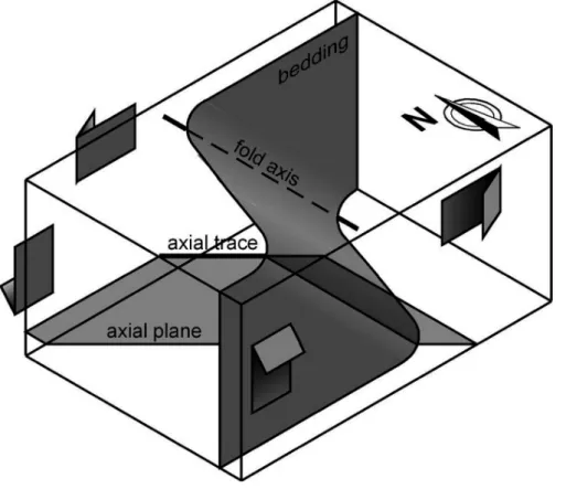
Monoclinal folds
The whole study area is crossed by a set of nine mono-clinal folds (labelled 1 to 9 in figure 1a). In the selected area, Fold 1 deforms dykes and is not displaced along the thrust surface (Fig. 2a). All over the study area, late fold axes moderately plunge towards the east (Fig. 2b-vii). Axial planes trend NW-SE with moderate dip towards the NE.
Discussion
Geometry and kinematics of the conjugate faults, the oldest structures recognised in the study area, are con-sistent with either conjugate sets of strike-slip faults reflecting roughly N-S shortening of the basin or syn-sedimentary normal faults developed in a pull-apart basin and passively rotated by E-W sinistral shear and folding. The brittle character of both fault sets and the occurrence of faults with the same orientation and kinematics cutting across Silurian, Ordovician and Dalradian rocks in the whole region suggest that they originated as N-S shortening-related conjugate strike-slip faults after regional E-W folding of the Silurian basin rather than syn-sedimentary normal faults. The
conjugate strike-slip faults may reflect flattening during the late stages of the E-W folding. It follows that conjugate faults and younger structures devel-oped in nearly vertical E-W trending strata and did not suffer important passive rotation. Conjugate strike-slip faults and regional E-W folding accom-modated up to 5% and 30% N-S shortening of the basin respectively.
In turn, kinematics and orientation of late sinistral strike-slip faults and late monoclinal folds are con-sistent with ca. E-W shortening. Development of these structures may be interpreted in several ways. They may reflect regional change in shortening direction or “local stresses imparted to the adja-cent wedge-shaped fault blocks” (from Stubley, 1989) in a continuous N-S compression of the basin. Moderate plunge to the east of the monocli-nal fold axes implies that these folds were pro-duced by oblique rather than horizontal deforma-tion. In fact, the overall geometry of the monocli-nal folds is consistent with E-W sinistral shear accompanied by vertical shear producing lowering to the north (Fig. 3). This observation suggests that the late stages of deformation of the basin were characterized by sinistral transtensional deformation rather than local layer-parallel short-ening in continuous N-S compression. In the
studied area, late sinistral strike-slip faults and late folds accommodated 15% and 8% of E-W short-ening respectively.
The early and late stages of deformation are separated in time by emplacement of serpentinitic dykes and development of north dipping thrusts. The kinemat-ics of the thrusts is not well documented and only a bulk NE-SW shortening direction can be inferred from offset of passive markers. SW displacement may indicate an intermediate shortening direction between early and late stages of deformation or it may just reflect late sinistral reactivation of an early stage southward thrust.
Several evidence suggest that dykes at Shivlagh Rocks originated from remobilization of underly-ing serpentinite rocks of the Clew Bay Supercomplex during tectonic deformation, as suggested by Phillips et al. (1970). If this is the case, most of the oblique displacement along the Emlagh Fault, separating the non-metamorphic Louisburgh-Clare Island Succession from the metamorphic rocks of the Clew Bay Supercomplex and the Croagh Patrick Succession, was accommodated before dyke emplacement since alignment between dykes and source rocks is still preserved (Fig. 1b).
The tectonic record within the Silurian basin may be interpreted as superposition of transtensional defor-mation on dominant N-S compression, or strong par-titioning of the strain during the early stage of a con-stant transpressional/transtensional deformation. Evidence for late E-W shortening-related structures overprinting early N-S shortening-related structures within the Ordovician rocks of the Central Murrisk, south Co. Mayo (Erriff phase, Dewey, 1967) and in the Croagh Patrick Succession (F2 folds, Long et al., 2005) supports the first hypothesis and suggests that the structural record within the Louisburgh-Clare Island Succession reflects a regional rather than a local tectonic evolution.
Early structures are consistent with the Late Silurian pure-shear dominated convergence documented in the area. Late transtensional deformations were prob-ably contemporaneous to the emplacement of the Ox Mountain syn-tectonic granitic bodies (410-400 Ma; McCaffrey, 1992; Flowerdew et al., 2000) and gener-al transtensiongener-al deformation recorded in Early-Middle Devonian times along the main tectonic lin-eament in northwest Ireland. The undeformed Corvock Granite dated at about 390 Ma (Graham et al., 1989; O’Connor, 1989) record the end of sinistral displacements in the area.
No evidence of syn-sedimentary structures has been found in the section suggesting that, if the Louisburgh-Clare Island Succession deposited in a pull-apart basin, transtensional deformations were probably limited to the basin bounding faults. The kinematics of the Emlagh Fault is consistent with the kinematics of late structures postdating early N-S shortening of the basin. Because no evidence of syn-sedimentary activity of the fault have been
document-ed so far, it is not possible to rule out development and activity of the Emlagh Fault only during the late stages of deformation of the basin.
Conclusions
Structural analysis of the Turlin Strand-Shivlagh Rocks section suggests that the Louisburgh-Clare Island basin experienced two main stages of deforma-tion.
The regional E-W folding of the Late Silurian suc-cession and the extensive conjugate strike-slip faulting are consistent with an early stage of N-S shortening of the basin. The latter structures are interpreted to reflect flattening during the final stage of folding. Late sinistral strike-slip faults and monoclinal folds are interpreted as evidence for the onset of transtensional deformation within the basin during the late stages of deformation. Early structures may have formed in Late Silurian times during a general pure shear dominated conver-gence (Caledonian Orogeny) while late structures are probably related to Early-Middle Devonian uplift and transtensional reactivation of the area accompanied by intrusion of syn-tectonic granites. Superposition of wrench- on pure shear-dominat-ed deformations probably reflects regional tecton-ic changes triggered by the peak of the Acadian orogeny in late Lower Devonian times.
Acknowledgements
Enrico Tavarnelli and John Dewey are thanked for helpful discus-sions. The research project was partly funded by the Irish Department of Education and Science, International Section, Dublin.
References
DEWEY, J. F. (1967): The structural and metamorphic history of
the Lower Palaeozoic rocks of central Murrisk, Co. Mayo, Eire. Q. J. Geol. Soc. London, 123: 125-155.
DEWEY, J. F. and RYAN, P. D. (1990): The Ordovician evolution of the South Mayo Trough, western Ireland. Tectonics, 9: 887-901. DEWEY, J. F., MANGE, M. A. and RYAN, P. D. (2005): The Clare
Island-Louisburgh Basin and the Slieve Gramph Plutonic Complex: Silurian transtension in regional transpression. In:
“Recent Developments In The Geological History Of The British Isles – A Tribute To W. Stuart McKerrow”, Oxford, January 14th-16th, 2005, Abstracts Book: 18-19.
FLOWERDEW, M. J., DALY, J. S., GUISE, P. G. and REX, D. C.
(2000): Isotopic dating of overthrusting, collapse and related
granitoid intrusion in the Grampian orogenic belt, northwestern Ireland. Geol. Mag., 137: 419-435.
GRAHAM, J. R., LEAKE, B. E. and RYAN, P. D. (1989): The Geology of South Mayo, Western Ireland. Scottish Academic Press, Edinburgh, 75 pp.
LONG, C. B., MCCONNELL, B. J. and PHILCOX, M. E. (2005):
Geology of South Mayo. Geol. Surv. Ireland Bull., 164 pp. MCCAFFREY, K. J. W. (1992): Igneous emplacement in a trans-pressive shear zone: Ox Mountains igneous complex. J. Geol. Soc. London, 149: 221-235.
O’CONNOR, P. J. (1989): Chemistry and Rb-Sr age of the
Corvock Granite, western Ireland. Geol. Surv. Ireland Bull., 4: 99-105.
environ-ments and palaeogeography of the Silurian strata of Clare Island, Co. Mayo, Ireland. J. Geol. Soc. London, 130: 19-41.
PHILLIPS, W. E. A., RICKARDS, R. B. and DEWEY, J. F. (1970): The
Lower Palaeozoic rocks of the Louisburgh area, Co. Mayo. P. Roy. Irish Acad., 70B: 195-209.
SOPER, N. J., STRACHAN, R. A., HOLDSWORTH, R. E., GAYER, R. A. and GREILING, R. O. (1992): Sinistral transpression and the