Thank you for your friendship and for all your help thus far, especially in editing this book. Geert Sterk, thank you very much for guiding the course I took with you, for your help and friendship. Tech Lucinda Chávez and Luchi, thank you very much for your help in the field and with the farmers.
Introduction
Introduction
- Erosion in the Andes
- Multiscale approach
- Soil erosion modeling
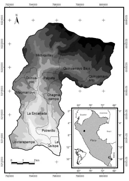
- Study area
- Thesis outline
- References
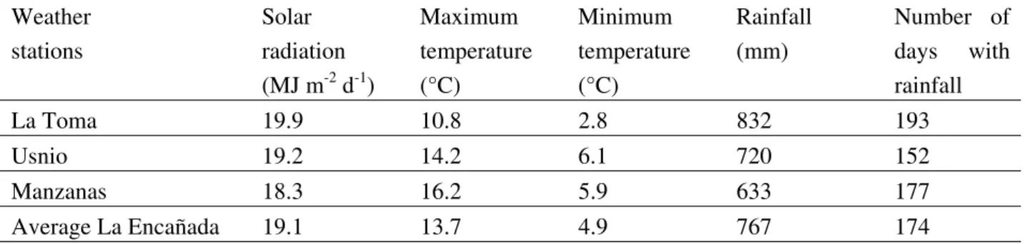
Most of the watershed area presents sandy loam, and the dominant level of soil organic matter is medium to high (above 2%). The purpose of the study described in this thesis was to analyze the erosion process at different scales in the La Encanada watershed using. A general introduction to the La Encañada area and the development of the method is given in Chapter 1.
Rainfall erosivity in the northern Andean Highlands of Peru
The case of La Encañada watershed
Rainfall erosivity in the northern Andean Highlands of Peru: The case of La Encañada watershed
- Introduction
- Materials and methods
- Results and discussion
- Conclusions
- References
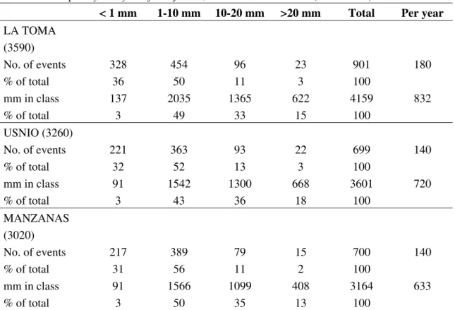
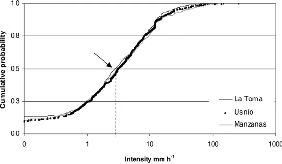
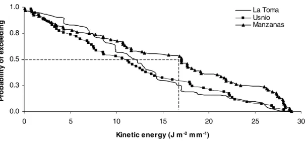
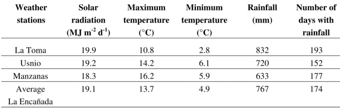
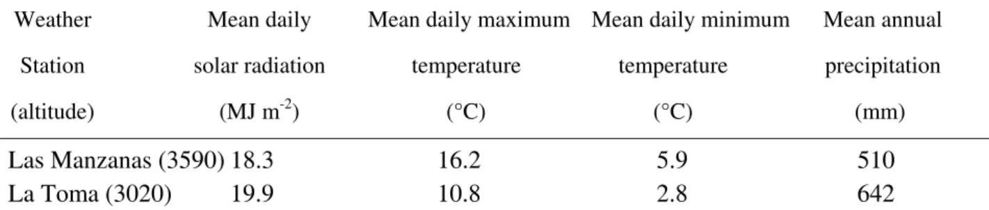
According to the duration analysis, 50% of the total rainfall events in the catchment were shorter than 2 hours. The minimum was at the La Toma meteorological station, in the highest part of the watershed: 20.3 J mm m-2 h-1. The most intense events can be expected at the bottom of the catchment (Manzanas weather station) and the least intense events at the top of the catchment (La Toma weather station).
Soil erodibility in the northern Andean Highlands of Peru
Soil erodibility in the northern Andean Highlands of Peru: The case of La Encañada watershed
- Introduction
- Material and methods
- Results and discussion
- Conclusions
- References
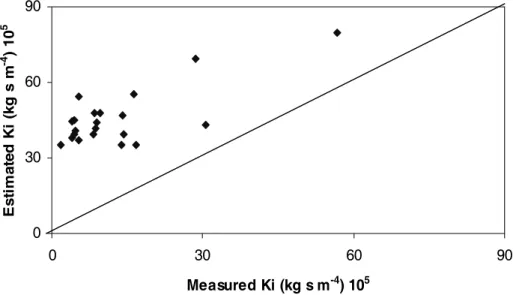
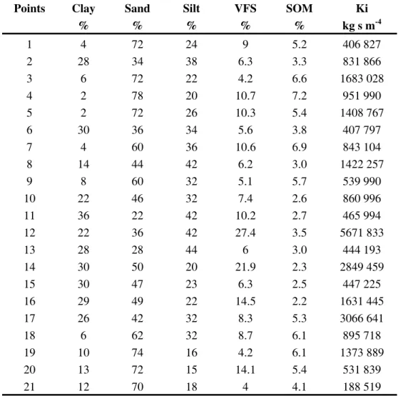
With the development of the Universal Soil Loss Equation – USLE (Wischmeier and Smith, 1978) – the identification of the "K" factor of soil erodibility became a central issue in erosion studies (Bryan et al., 1989). The dominant soils in La Encañada are classified as Entisols (Fluvents), Inceptisols (Ochrepts and Umbrepts) and Mollisols (Aquolls and Ustolls) in the US surface response showing the relationship between interrill erodibility (Ki), stream erodibility and Wischmeier's) for soils of the La Encañada watershed, Peru.
Uncertainty analysis of WEPP for La Encañada, Peru
Uncertainty analysis of WEPP for La Encañada, Peru
- Introduction
- Materials, methods and results for the data collection
- Materials and methods of the uncertainty analysis
- Results of uncertainty analysis
- Conclusions
- References
This consisted of a broad examination of all WEPP input parameters at the watershed scale, followed by an uncertainty analysis of the WEPP model. The uncertainty of the model was tested for the observed domain of the input variables. An uncertainty analysis differs from a sensitivity analysis in that only the local variation of the input variables is used.
Each plot is cleared before installing the simulator, trying not to disturb the soil surface. Second, the Manzanas (characterized by the greatest number of high-intensity rainfall events) is the prevailing climate in the lower part of the watershed. Potato can be considered a more erosive land use than barley or fallow because its management involves more disturbance of the soil surface (for example, plowing the soil to create rows that can act as large streams).
Various conclusions can be drawn from the uncertainty analysis of the WEPP model reported above and summarized in Table 4.8. The WEPP model reflected very well the high erosivity of the Manzanas climate compared to the La Toma climate. The maximum runoff estimated was 80.4 mm y-1 (15% of the total annual rainfall under the Manzanas climate, under fallow), the minimum was 4.5 mm y of the total annual rainfall under the La Toma climate and barley).
This low value is related to the high hydraulic conductivity of the deep organic soils (the least erodible soils).
Validation of the hillslope version of WEPP in La Encañada watershed, northern Peru
Validation of the hillslope version of WEPP in La Encañada watershed, northern Peru
- Introduction
- Materials and methods
- Results and discussion
- Summary and conclusions
- References
A slope version of the Water Erosion Prediction Project (WEPP) was used to simulate runoff and soil loss for three different sites within the La Encañada watershed in the northern Andes of Peru. The process of erosion is highly variable in the diverse agricultural ecosystems of the Andean highlands. This chapter describes how the performance of the slope version of the WEPP model in predicting runoff and soil loss in the La Encañada watershed in northern Peru was tested by comparing the results with data measured at runoff plots.
La Encañada: The soil belongs to the family of Fluventic haplustolls (INRENA, 1998), developed from alluvial material and located at the bottom of the basin (3150 meters above sea level). La Toma: The soil belongs to the family of typical haplumbrepts (INRENA, 1998), developed from a colluvial-alluvial material and located at the top of the basin (3550 meters above sea level). The transport capacity of runoff can limit soil loss even in the most erodible soils.
Summary statistics of the WEPP model validation for runoff, stratified according to runoff area size. Summary statistics of WEPP model validation for soil loss stratified according to runoff area size. Testing different slope lengths was useful for a better understanding of soil loss and runoff on the steep slopes of the Peruvian Andes.
Preliminary study on the use of the 137Cs method for soil erosion research in the Pampean region of Argentina.

Assessment of erosion hotspots in a watershed: integrating the WEPP model and GIS in a case study in the Peruvian Andes
Assessment of erosion hotspots in a watershed: integrating the WEPP model and GIS in a case study in the Peruvian Andes
- Introduction
- Materials and methods
- Results and discussion
- Conclusions
- References
Therefore, GEMSE is an option that can be used for strategic applications of the WEPP model. In the highest part of the watershed there are deep soils with a high content of organic matter. In a second approach, we validated the hillslope version of the model for the Northern Andes of Peru and found adequate predictions for runoff and soil loss.
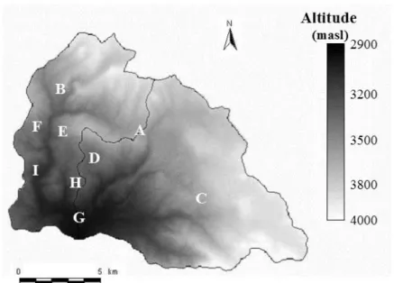
When using the slope version of the WEPP model, the main output maps are soil loss (kg ha-1) and runoff (mm). In this case study in the La Encañada watershed, potatoes, cereals and fallow land use were simulated in different areas according to the land use map of the study area (INRENA, 1998). The northern part corresponds to the highest part of the basin, where deep soils are present and La Toma climate prevails.
80% of the surface area had estimated values of runoff < 5 mm, as we can see in the histogram (Figure 6.7a). Generation of these maps facilitated the visualization of the erosion process at spatial and temporal scales according to the actual land use of the watershed. This shows that GEMSE is a viable option for strategic applications of the WEPP model.
Histograms showing the percentage of area under different estimated values of runoff (a) and soil loss (b).
Methods for erosion assessment in the Andes
- Introduction
- The multi-scale approach
- The small plot scale
- The runoff plot scale
- The watershed scale
- Conclusions
- References
The La Encañada basin has stony soils; this hindered the installation of the frame to demarcate the plot. The slope of the regression line is Kr, and the intersection with the horizontal axis is the critical shear force, τc. The intersection of the trend line with the horizontal axis is the critical shear value (τc).
Rollopampa: Plots were installed at the beginning of the rainy season in 2000. The smallest plot was 5 m long; the second was 10 m long and the largest was 15 m long. In the latter plot, despite the erodible soil and the steep slope, seven of the nine events showed no soil loss at all (0 Mg ha-1). The soil type covers part of the watershed and the lack of runoff and soil loss reflects the good physical/hydraulic properties (chapter 3) and the low erosivity of the rainfall events in the area (chapter 2).
The sampling technique consisted of taking three one-liter samples of water containing suspended sediment in the middle of the channel. At point A, in the upper part of the watershed, water but no sediment was found. The effective hydraulic conductivity was derived from the measured values of saturated conductivity (Ksat/field) using a voltage infiltrometer.
In this Chapter 5, the validation of the hillslope version of the WEPP model showed a better correlation between observed and estimated runoff and soil loss when large plots were tested.
Conclusions
Conclusions
This area experiences higher intensity rainfall, while lower intensity events occur in the upper part of the catchment. Various conclusions can be drawn from the uncertainty analysis of the WEPP model and these are summarized in Table 4.8. However, the small quantities result in the measurement accuracy being low, which hinders the validation of the WEPP model.
Despite the general observation that runoff and soil loss were very low, there was one exception. Generation of such maps facilitated the visualization of the erosion process at spatial and temporal scales according to the actual land use in the watershed. In that chapter, the validation of the hillside version of the WEPP model showed a better correlation between observed and estimated runoff and soil loss when large plots of land were tested.
This can be attributed to the low erosivity and erodibility of the different soil types in the basin. The advantage of validating the WEPP model is that many scenarios typical of the highlands can be simulated without the need to install new runoff plots in the field. A general introduction to the study area (La Encañada watershed) in the northern Andean highlands of Peru and the development of the methodology are given in Chapter 1.
To better understand erosion processes in the Andes, a slope version of the WEPP model was validated for three different sites in La Encañada.
Resumen
- Erosividad de las lluvias en los Andes del norte del Perú: El caso de la cuenca del río La Encañada
- Erodabilidad del suelo en los Andes del norte del Perú: el caso de la cuenca del río La Encañada
- Validación de la versión para laderas del modelo WEPP en la cuenca del río La Encañada en el norte de Perú
- Análisis de las áreas de mayor riesgo a erosionarse dentro de una cuenca
- El enfoque a múltiple escala: métodos para el análisis de la erosión en los Andes
- Conclusiones
Para comprender mejor el proceso de erosión en los Andes, se validó la versión de pendiente del Proyecto de Predicción de Erosión Hídrica (modelo WEPP) para tres ubicaciones diferentes en la cuenca de La Encañada. Los modelos ambientales basados en procesos físicos nos permiten analizar las causas y efectos de la erosión. Por lo tanto, el Capítulo 6 presenta una interfaz llamada Modelado Geoespacial de Pérdida de Suelo (GEMSE): una herramienta que integra cualquier SIG con el Proyecto de Predicción de la Erosión Hídrica (WEPP).
El uso de GEMSE se ha aplicado a la evaluación de pérdidas de terreno en La Encañada donde se ha validado la versión de pendiente WEPP. Los resultados muestran la distribución espacial de la escorrentía y la pérdida de suelo en forma de mapas. La erosión hídrica se midió a tres escalas diferentes en la cuenca del río La Encañada.
Fue necesario evaluar todos los parámetros del suelo relacionados con la erosión a nivel de parcela y parcelas de escurrimiento para la validación de la versión de pendiente del modelo WEPP en la cuenca La Encañada. En el caso de la conductividad hidráulica los valores fueron elevados para todos estos suelos. Las parcelas más pequeñas produjeron más escurrimiento y pérdida de suelo en comparación con las parcelas más grandes; Según la validación con WEPP, los sitios más grandes son los más adecuados para la investigación de la erosión.
La erosión medida y prevista de los campos agrícolas en la cuenca del río La Encanada es baja.