Moreover, I am indebted to the Dean of the Post Graduate School, University of Jos, Professor W. Lakka and a host of others for their collective, untiring and special attention generally paid to the postgraduate students of the department.
CHAPTER ONE INTRODUCTION
BACKGROUND OF THE STUDY
Obamiro (2008) stated that with increasing population pressure in Nigeria and the associated need for increased agricultural production (both food and fiber crops as well as livestock), there is a clear need for better management of the country's agricultural resources. Reducing erosion in the upper reaches of the watershed also helps reduce sedimentation in the lower reaches.
STATEMENT OF THE RESEARCH PROBLEM
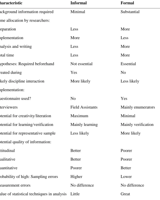
To achieve this objective, satellite remote sensing and GIS technologies, supplemented by existing conventional methods, have been applied to the analysis of agricultural systems in the Lower River Benue Basin (LRBB). How can satellite remote sensing and GIS techniques be used in the analysis of agricultural systems in LRBB for effective planning and improved decision making.
AIM AND OBJECTIVES OF THE STUDY
What are the land management techniques used by the farmers and other agriculture-related institutions to improve the performance of agricultural systems in the area. What are the limitations (institutional and environmental) to sustainable agricultural land use in the area.
THEORETICAL FRAMEWORK
To identify the institutional and environmental constraints to sustainable use of agricultural land in LRBB. Only then can we analyze the prevailing agricultural systems in the Lower River Benue Basin using satellite remote sensing and geographic information system technologies.
SCOPE OF THE STUDY
It is neither an exaggeration nor an overstatement to say that in the lower Benue River basin no previous study has clearly mapped or clearly differentiated the various agricultural systems that are functional in the area. This formed the basis for the identification and analysis of different agricultural systems in the area.
JUSTIFICATION OF THE STUDY
Population growth in the area together with the changing ecosystem of the Benue and Katsina-Ala rivers have resulted in a decline in agricultural production, which has called for a holistic assessment of existing agricultural systems in order to determine ways to support agricultural intensification and to improve nutrition. production as necessary variables to address issues of food security and sustainable socio-economic development in the basin. Information on current land use constitutes the starting point in land use planning and management in LRBB.
THE STUDY AREA
- Geographic Location and Extent
- Geology
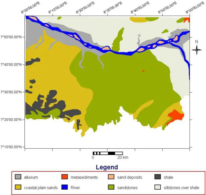
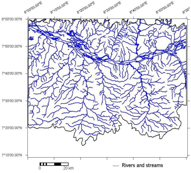
- Relief, Drainage and Hydrology
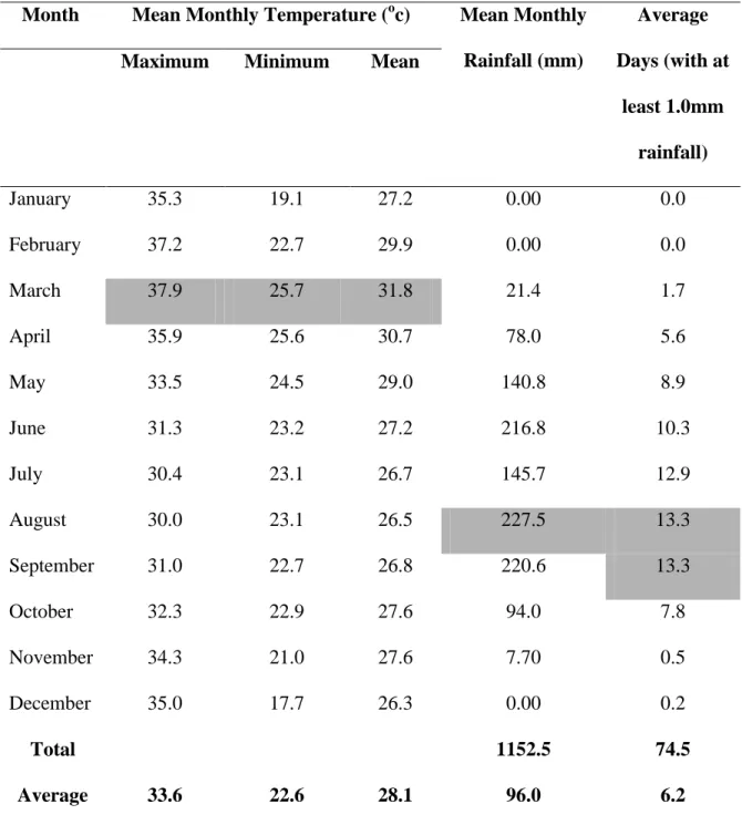
- Climatic Characteristics of the Study Area
The duration of the rains strongly influences the level of water availability in an area and affects the spectral response of surface features, especially vegetation and soil. This has a major impact on the general state of agricultural land use in the area, thereby promoting irrigated farming along the Benue River and other major rivers and streams.
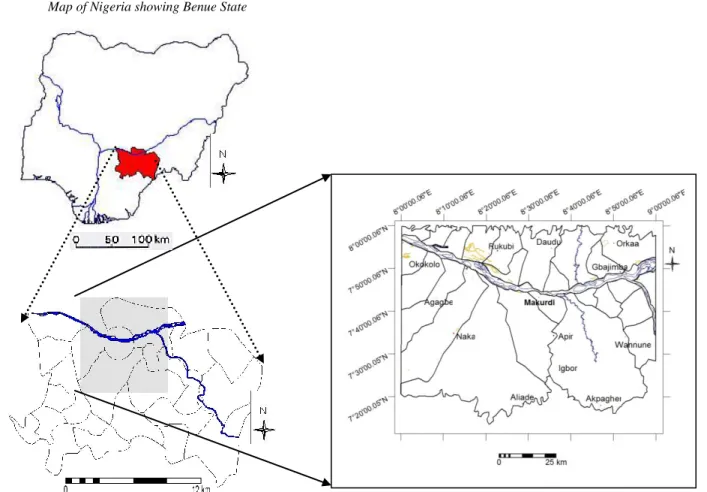
- Soils
- Vegetation
- The People and Economy
The dominant soil type in the Benue Basin section of the Lower River is the ferralsols and hydromorphic soils. This has given Benue State, which is located in the area, the position of the 'Food Basket of the Nation'.

CHAPTER TWO
REVIEW OF RELEVANT LITERATURE
INTRODUCTION
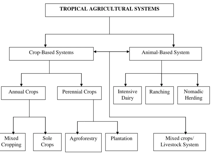
AGRICULTURAL SYSTEMS IN THE TROPICS
- Characterization and Mapping of Agricultural Production Systems
- Factors that influence the Nature and Scope of Farming Systems
- Traditional Farming Systems
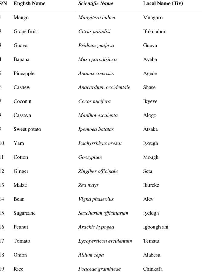
- Crop Farming
This study focuses mainly on static analysis, which is the comparison of agricultural systems at a point in time. Exogenous factors (ie the social environment) are largely beyond the control of the individual farm family. Labor productivity — The marked seasonality of agriculture in floodplains means that there are peak labor demands for fairly short periods, followed by longer periods of lower demand.

Grain crops
In some parts of the world, most grain production is on large farms, where agricultural machinery does the tilling, planting and harvesting. The development of improved cereal crop varieties with higher yields, greater resistance to pests and greater response to fertilizers in the 1960s improved productivity worldwide. In many areas of the tropical belt, the new development triggered the so-called Green Revolution, a dramatic increase in grain production.
Forage crops
This is less true in the tropics like Nigeria and in places where the terrain is too rough for machinery. In these areas, grain is grown on small farms and much of the planting, harvesting and threshing is still done by hand or with primitive equipment.
Fruit crops
Groundnut and coconut are the most important nut crops and are common sources of food and edible oils. Most other types of nuts are grown primarily for food; notable exceptions include peanuts, which are grown for industrial oils, and kola nuts, which produce caffeine, a stimulant.
Vegetable farming
Insect and disease control is especially important in commercial plantings and must be carefully tailored to the individual pest and crop. broccoli, cauliflower) and a variety of other species grown for their fruits or seeds (peas, beans, sweet corn, pumpkins, melons, tomatoes). Most common vegetable varieties used for agriculture were developed in temperate regions, but some are adapted to the tropics. They must have knowledge of soil preparation, planting and growing crops, weed and pest control and water management.
Non-food crops
Energy-producing crops
- Livestock Farming
- THE CONCEPT OF FOOD SECURITY
- Major Issues in Food Security
- Global Concern about Food Security
- PRINCIPLES OF AGRICULTURAL SYSTEM ANALYSIS
- Land
- Land Resources
- Land Cover
- Land Use Systems, Analysis and Planning
FAO (2000) stated that over seventy percent of the food insecure population in Africa lives in rural areas. Knowledge of current land use (and land resources) is necessary for formulating changes that lead to sustainable resource use. Land aspects are very important for accurate performance analysis of a land use system.

Land use system
According to Fresco et al (1994), the concept of the land use system in sustainable land management encompasses a set of components. The Output: contains the objective of the land use system, namely a sustainable and optimal land use and the establishment of four orders of land management. Currently, land use planning almost implicitly means the development of sustainable production systems for a given region.

Land use systems analysis
For the integration of different research disciplines, the creation of development scenarios of sustainable land use systems is considered an effective mechanism, as it requires the identification and quantification of the inputs and outputs of one and the other. The creation of such development scenarios enables the identification of technologies and interventions at different scales and moments, as well as the priority tasks of agricultural research. 1 Defining and shaping the vision and common goals of farmers, researchers and land use planners.
Land use planning and management
- River Basin and Floodplain Agriculture
- Sustainable Agricultural Land Use
- DYNAMICS OF THE RIVER BENUE ECOSYSTEM
- RIVER BASINS DEVELOPMENT IN NIGERIA
- Names of Authority, Area of Operation and Headquarters
- The Lower Benue River Basin Development Authority (LBRBDA)
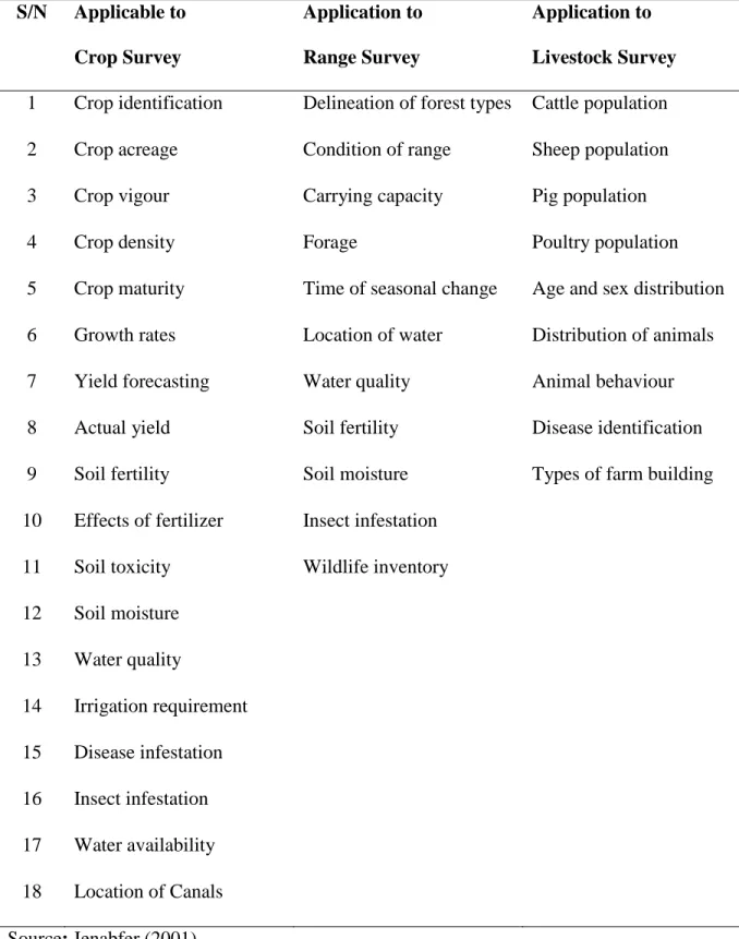
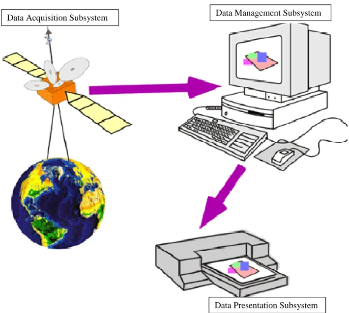
- REMOTE SENSING AND GIS APPLICATIONS IN AGRICULTURE .1 Satellite Remote Sensing Technology .1 Satellite Remote Sensing Technology
- Electromagnetic Spectrum (EMS)
- Agricultural Remote Sensing
This planning must be based on an understanding of both the natural environment and the type of land use that is intended. Most of the decisions will be irreversible, so the importance of sound spatial planning is obvious”. Two concepts are fundamental to the sustainable use and management of the earth's natural resources.

Relevant resolutions in agricultural remote sensing
Spatial resolution refers to the size of the smallest object that can be detected in an image. The smaller an area represented by one pixel, the higher the resolution of the image. Higher radiometric resolution allows a remote sensor to provide a more precise image of a specific portion of the electromagnetic spectrum.
Wavelength regions for agricultural surveys
Temporal resolution refers to how often a remote sensing platform can provide coverage of an area. Remote sensing obtained from cameras mounted on aircraft is often used to provide data for applications that require more frequent sensors. Johannsen (2005) in his study on advances in remote sensing agriculture stated that remote sensing devices operate in the green, red and near-infrared regions of the electromagnetic spectrum for agriculture and other allied phenomena.
Areas of remote sensing applications for agricultural surveys
Spatial variations are changes in radiation from one place to another, i.e. difference in shape and position. Temporal variations are changes in radiation from one time to another, i.e. difference over time. One of the most successful applications of multi-spectral space imagery (sensor) is to monitor the state of the world's agricultural production.
Importance of remote sensing in agricultural surveys
Cost savings - The costs are relatively small compared to the benefits that can be obtained from the interpretation of satellite images. Real-time capabilities – The speed at which images can be acquired and interpreted can help eliminate the timeliness blockage that plagues so much agricultural research. It is necessary to note that land use data collected at ground level is certainly not eliminated by the use of remote sensing, but it does significantly improve the efficiency with which ground data can be collected.
The use of hyper-spectral imaging in agriculture
- Geographic Information Systems (GIS)
In light of this, a combination of GIS and Remote Sensing provides very essential ways to obtain the best information that can be desired. Applications of GIS to agricultural research and related areas of rural development are limited only by the human imagination and by the quality and resolution of available data. A related domain of GIS work is the exploration of new land use opportunities, particularly for agricultural development.
GIS GIS
ProceduresProcedures
Data Data
HardwareHardware
SoftwareSoftware
People
Remote Sensing and GIS Applications in Land Use Studies
Third, they demonstrate the performance of interactive remote sensing and GIS techniques in inventory; presentation and analysis of information on land use and land cover in the area. In addition, Rao (1996) using the IRS - IA (Indian Remote Sensing) application to map land use and land cover in India emphasized that land use and land cover inventories are necessary for optimal use and management of land resources in the country. Jenabfer (2001) reiterated that land use and land cover data are one of the most important data layers in any geographic information system for an agricultural resource.
CHAPTER THREE
MATERIALS AND METHODS
- MATERIALS
- Collateral Datasets
- Satellite and Web-Based Datasets
- METHODS
- Pre-Fieldwork, Initial Preparation and interpretation of satellite imageries
- Reconnaissance Survey
- Detailed Fieldwork and Surveys
- GPS FIXES AND LOCATIONAL ATTRIBUTES
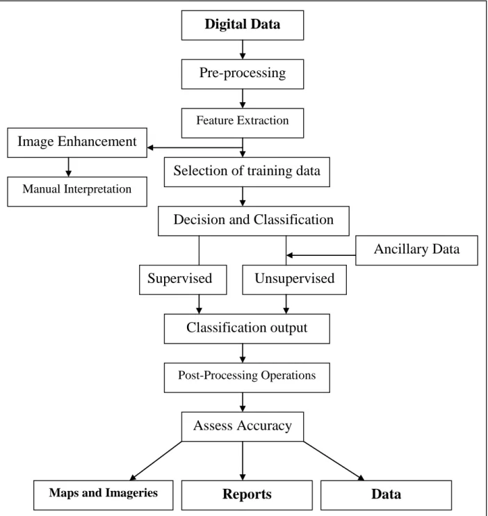
- Digital Image Manipulation and Laboratory Analysis
- Image processing and analysis
- Analysis of agricultural systems and land use/land cover
- Generation of slope percent and slope class maps
- Generation of DEM and 3D Visualization
- Generation of NDVI
- Analysis of morphometric parameters for the sub-watersheds in the LRBB
- Prioritization of the sub-watersheds for improved agricultural production
- Database creation on agricultural land use systems in the LRBB
The creation of conceptual databases and models was also undertaken to demonstrate the relationships between entities and attributes as they affect agricultural land use systems in the lower Benue River Basin. The percent slope map together with the SRTM data formed the basis for further slope calculations for agricultural land use analysis in the lower Benue River basin. NDVI was calculated by calculating the ratio of VI (vegetation index, i.e. the difference between channels 2 and 1) and the sum of channels 2 and 1.
SOIL ROAD
CROPS/
ANIMALS
RIVER
MARKET
SETTLEMENT
FARMERS
Report Preparation and Presentation
In this final phase, the results of material search, field investigations and laboratory manipulation were prepared, compiled and presented in the form of text, maps, tables and plates as the final project report entitled 'Mapping and Analysis of Agricultural Systems in a part of the Benue River Basin, Nigeria”.
CHAPTER FOUR
THE PHYSIOGRAPHIC UNITS OF THE LRBB