The purpose of this Environmental Impact Assessment (EIA), as required and specified by Chatham County Ordinance 6.2.B, is to evaluate the potential environmental impacts associated with the proposed Jordan Dam road storage development. The proposed project will serve as storage primarily for boats, recreational vehicles and household items. The proposed site plan includes indoor and outdoor storage areas on +/- 38.4 acres of undeveloped, wooded land.
Future plans may include retail sales and rentals, which will increase sales and property tax revenue for the district. The proposed project will provide necessary services to nearby residents and visitors from outside the district. These services meet many of the objectives outlined in the Chatham County Land Use Plan (2017), taking into account potential impacts on surrounding human, cultural and environmental resources.
General Site Description
Project Description
This project focuses on multiple strategies outlined in the Chatham County Land Use Plan (LUP) (2017), including reducing retail leakage into neighboring counties, supporting increased tourism and recreational facilities, increasing sales revenue and property taxes, and promoting small business development near village centers. The proposed indoor storage facility is located on the southwest corner of the site, adjacent to US-1 South and Moncure-Pittsboro Road. Nine one-story storage buildings, one BMP for stormwater management and approximately seventeen parking spaces are proposed for this area.
A fence and security gate are proposed for the boundaries of the external storage area and the second storm water management PKM. All surfaces are proposed to be gravel, although other impervious surfaces may be used, totaling approximately 508,410 sf. Tree removal and soil disturbance will be limited to the amount necessary for the storage facility.
Both indoor and outdoor storage areas will have 24-hour video surveillance in addition to electronic gate access.
Site Selection and Design Alternatives
No-Build Alternative
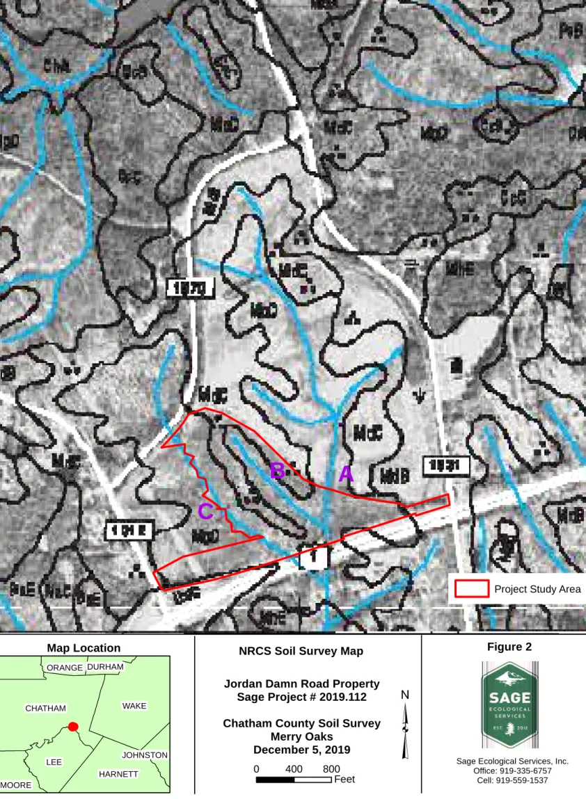
Geography
Soils and Prime Farmlands
6 will be designed to meet Chatham County and North Carolina Department of Water Quality requirements. A record review from the NC Department of Environmental Quality (NCDEQ) Division of Waste Management Site Detection Tool indicates no documented contamination at the Site or on adjacent properties.
Land Use
7 Land Use Policy Strategy 2.3 focuses on identifying village centers and intersection communities for small business developments throughout the province, if appropriately designed to be consistent with historical development patterns. The land use policy states that growth and development must occur within and near established planned activity centers. The proposed project meets these objectives through the development of a suitable small business within a designated village centre.
Land Use Policy 6 states that commercial and mixed-use development should be located along major highways and key intersections. The location is adjacent to the Moncure-Pittsboro Road exit from US 1, which is the intersection of a major freeway and a major collector route. Land Use Policy Strategy 6.1 restricts shopping centers and freeway commercial development to areas suitable for commercial development on the future land use map.
Land Use Policy Strategy 6.3 aims to amend land development regulations to push commercial development to nodes. The proposed project meets this objective by being located at the intersection of a major highway and a major collector route.
Wetlands
Public Lands and Scenic, Recreational, and State Natural Areas
Areas of Archaeological or Historical Value
Air Quality
Noise Levels
Light Levels
Surface and Groundwater Resources
As mentioned in Section 3.2 above, there is no evidence of contamination on or adjacent to the site according to the database search or the field review. All groundwater is expected to move from higher to lower elevations, usually from north to south on the site. New well construction will follow the guidelines and recommendations of the Environmental Health Department of Chatham County.
Sediment and erosion control measures will be implemented during construction and forested riparian buffers will be protected from logging and grading to reduce impacts to surface water on the site. Two stormwater management BMPs are proposed to accommodate stormwater runoff from the impervious portions of the site. These BMPs will continue to reduce pollutants and sediments released from the site into surface waters after construction is completed.
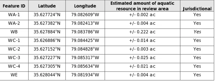
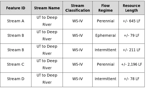
Fish and Aquatic Habitats
Wildlife and Natural Vegetation
The hardwood-dominated natural communities occupying the drainages at the site had overstory and understoreys of American beech, northern red oak, southern red oak, white oak, water oak, yellow poplar, sweet gum, red maple, and southern sugar maple. Invasive species observed at the site include Chinese privet, autumn olive, Japanese honeysuckle, and Nepalese browntop or Japanese stiltgrass. According to the NCNHP report dated December 12, 2019, no federally listed T&E species were documented at the site.
Two federally listed species, harperella and the Cape Fear Shiner, have occurred within a mile of the area. Although the Deep River is less than a mile from the property, suitable breeding and foraging habitat for bald eagles is not present on the property. 2 – USFWS Range by Basin Map shows Cape Fear shiner extending to the site; habitat requirements include substrates of gravel, cobbles, and boulders; The species is known from tributaries and headwaters of the Deep River and Cape Fear River in Chatham County.
According to the site plan (figure RZ01), approx. 18 hectares of existing forest on the site be cleared for the proposed development. Larger species such as white-tailed deer, fox, raccoon, opossum, squirrel, and birds will migrate to the remaining forested areas of the site located in the eastern portion of the site and along the drainages.
Hazardous Materials
During the construction of the site, preventive measures will be taken to prevent and reduce impacts on the environment and neighboring properties. Development of the site will require a zoning change for the property from R-1 to CD-CB. This request takes into account existing land use near the site and the potential for sales and property tax increases for the county.
Transitional Stream/Marginal Wetlands - Waters of Potential US Jurisdiction; Subject to 30/50-Foot Chatham County Buffers. Interrupted Stream - Jurisdictional waters of the US; Subject to 50-foot wetlands Chatham County Buffers - Jurisdictional waters of the US; Subject to the Chatham County Buffers 50-Foot Project Study Area. SITE LIGHTING (TYPE) NOTE: ANY LIGHTING SHALL COMPLY WITH SECTION 13 OF THE CHATHAM COUNTY ZONING ORDINANCE.
Sage) requests a State Historic Preservation Office Environmental Review for the +/-48.8 acre Jordan Dam Road Property (the Site) located east of the intersection of US-1 South and Moncure-Pittsboro Road in Moncure, Chatham County, NC. The purpose of this letter is to solicit feedback on any potential concerns and request a review of the site file. The scope of the project is a proposed storage facility consisting of indoor and outdoor storage areas.
Land use in the vicinity of the site consists of undeveloped, wooded land, rural residential, agricultural and grazing land, and some commercial properties to the south of Moncure. Twenty-one historic properties and one National Register Historic District are within 1.0 miles of the site boundary. Lockville Dam Canal and Powerhouse (CH0018) is a National Register property and is approximately 0.4 miles southwest of town.
Based on the project area mapped with your request, a query of the NCNHP database indicates that there are no records for rare species, important natural communities, natural areas and/or not. The attached 'Potential Occurrences' table summarizes rare species and natural communities documented within a one mile radius of the property boundary. Tables of natural areas and conservation/managed areas within a one-mile radius of the project area, if any, are also included in this report.
If a federally listed species exists within the project area or is listed within a one-mile radius of the project area, NCNHP recommends contacting the US Fish and Wildlife Service (USFWS) for guidance. Occurrences of natural heritage features, natural areas and managed areas within a one mile radius of the Jordan Dam Road Project area. Vascular plant 3981 Ptilimnium nodosum Harperella 1971-08 F 3-Middle threatened threatened G2 S1 Natural areas documented within a radius of one mile of the project area.
CPF/Rocky River Subbasin Aquatic Habitat R1 (Exceptional) C1 (Exceptional) Managed areas documented within a one mile radius of the project area.