The City of Truckee is committed to reducing the number of deaths and serious injuries on our streets. Focus Areas: Identifies the focus areas for the city based on the road safety performance assessment.
The crash data analysis revealed key findings that can help contextualize the safety needs in Truckee. Overall, the proportion of fatal and injury crashes involving pedestrians in Truckee is lower than the state average.
STRATEGIES
This section provides multidisciplinary recommendations for the town to consider when making investments and progress to improve road safety across the region.
EDUCATION AND PROMOTION
250,000 / location
LPI: $550 - $6,000
Dedicate space to cyclists within the public right-of-way to limit conflicts; it can be streaked, buffered or against the flow. It provides a designated space for cyclists to wait ahead of traffic at signalized intersections, increasing visibility and reducing right-hook collisions.
Indicates the intended path of cyclists through an intersection or over a ramp or ramp that increases visibility for all users.
FUNDING
Managing Agency: National Park Service LWCF provides matching grants to states and local governments for the acquisition and development of public outdoor recreation areas and facilities. Managing Agency: Office of Traffic Safety The California Office of Traffic Safety (OTS) strives to eliminate traffic deaths and injuries.
IMPLEMENTATION
Maintain an accurate collision database and routinely evaluate roadway safety
Educate motorists, bicyclists, and pedestrians on how to travel safely and limit the potential for collisions
Implement projects that make streets safer for every person
Integrate equity into the safety decision-making process
The city has identified actions that could be taken to begin addressing the important areas.
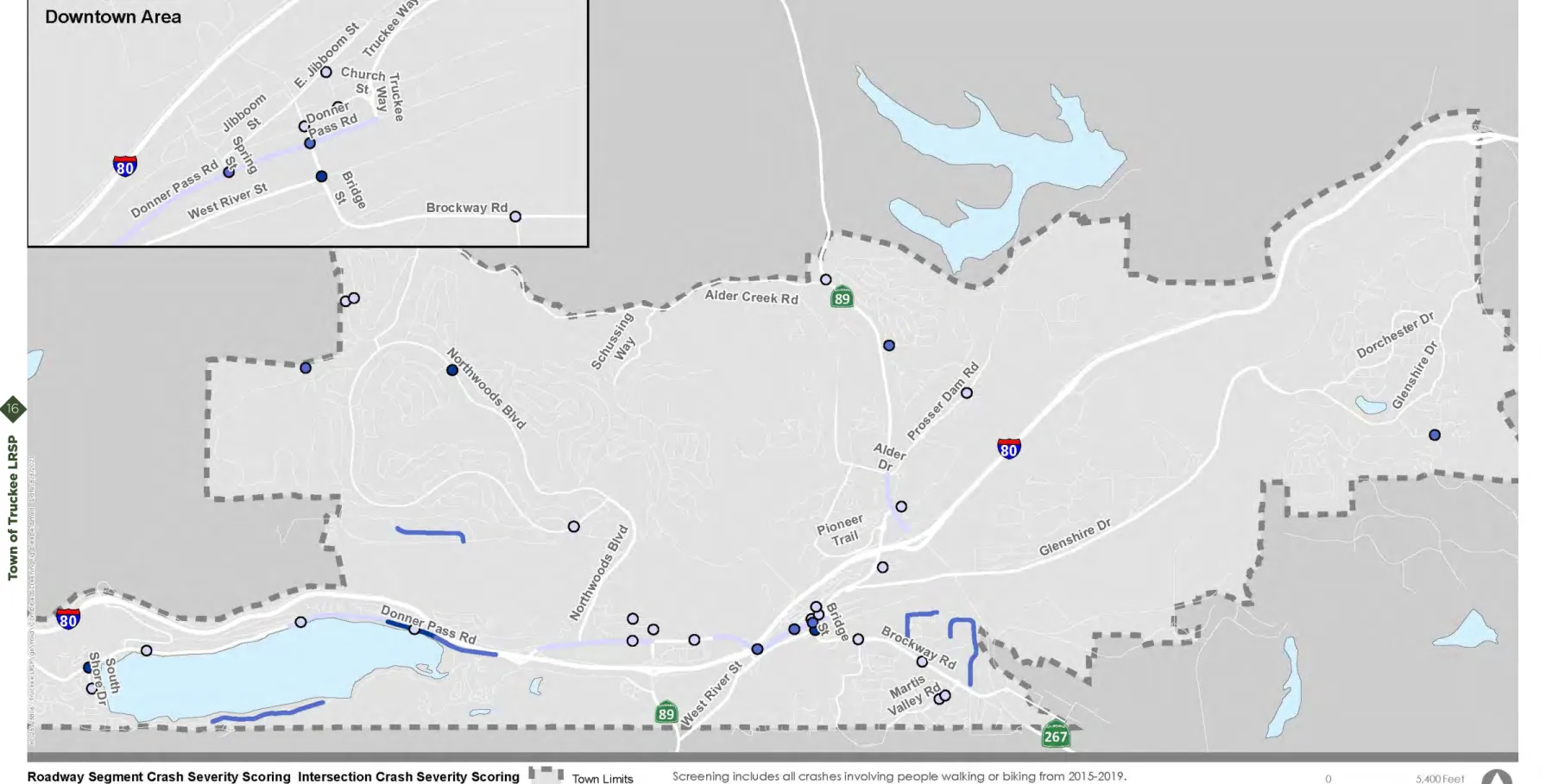
High Crash Frequency and Severity Locations
Speed Management
Safety for People who Walk and Bike
Coordination and Evaluation
There are a number of projects highlighted in the existing Fiscal Year (FY) 20/21 Capital Improvement Plan (CIP) which, when completed, will help address the highlighted areas and improve overall safety. More detailed information on the strategies can be found in the Town of Truckee's FY 20/21 CIP sheets, included in Appendix D.
Truckee River Legacy Trail Phase 4
Pioneer Trail and Bridge Street Extension
Northwoods Boulevard/Donner Pass Road Roundabout
West River Street Streetscape Improvement Project
C1712 I-80/Donner Pass Road/Coldstream Road Roundabout
C1805 Reimagine Bridge Street
Jibboom, Bridge, and Church Streetscape Improvements
DPR Corridor Improvement Study (Between Donner Memorial and East End Donner Lake)
Jibboom Street Sidewalk Feasibility Study and Improvement Project
Emergency Evacuation Planning
Envision DPR - Eastern Segment Improvements
2021 Roadways Brushing and Chipping Project
Downtown Railroad Pedestrian Crossing
Innovate Gateway
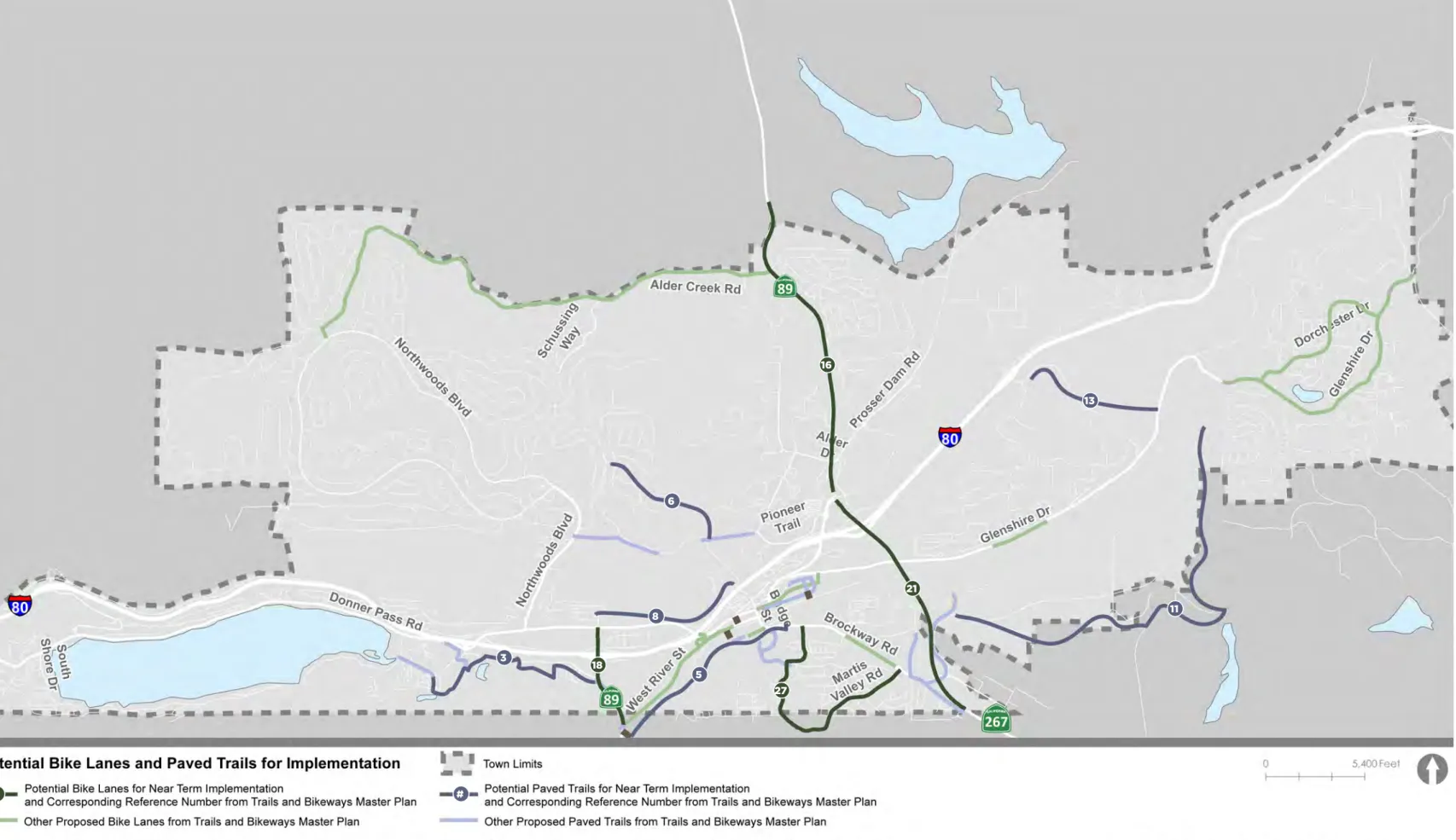
Roundabouts
Bike Lanes
Paved Trails
APPENDIX A
INTRODUCTION
SURVEY
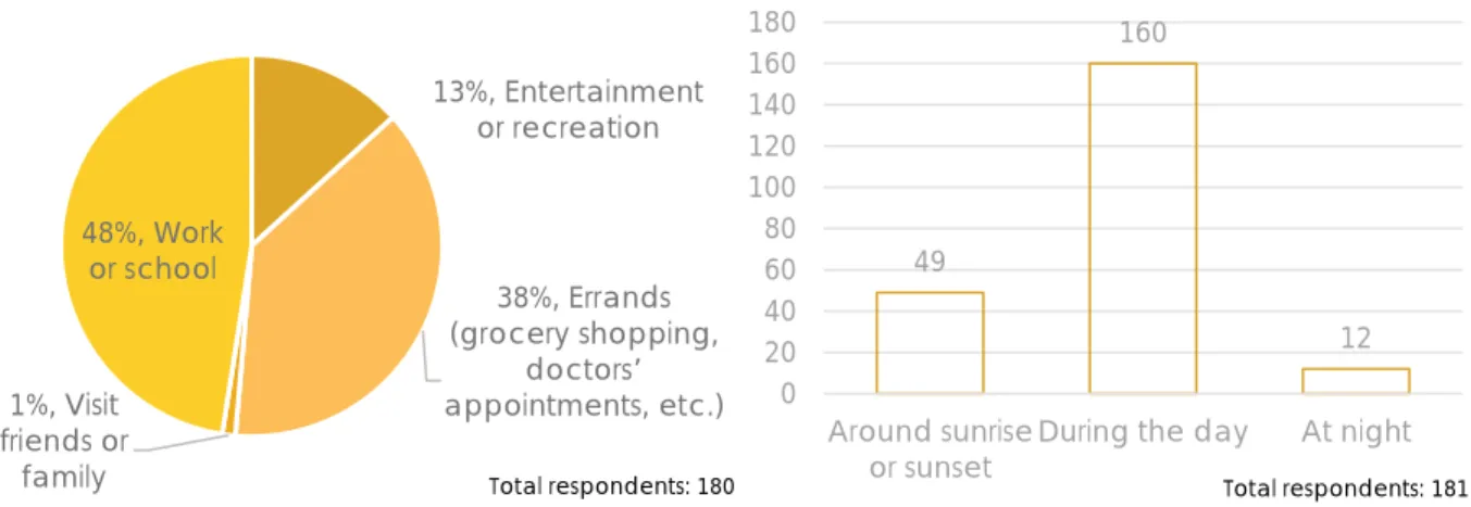
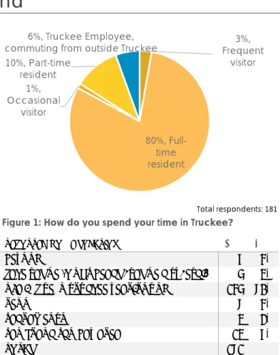
A full list of zip codes where people live can be found in APPENDIX A. Of the 160 people who answered the gender question, 47% identify as male and 53% as female.
Intersection/Crossing Improvements
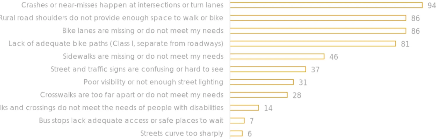
Signage: Many people suggested additional speed limit signs, as well as warning signs (watch for pedestrians, etc.), including electronic speed feedback signs. Line of Sight Assessment: It was noted that it is difficult to see around corners at intersections.
Biking Improvements
Prohibition of right turns at red lights: Restrictions on right turns at red lights have been proposed to make crossing intersections safer.
Congestion Management
Maintenance
INTERACTIVE MAP Background
Because the two comments classified as walking-related were about both walking and cycling, these two types of comments were combined. Most of the suggestions were about adding bike infrastructure (including bike lanes and roundabouts), improving crosswalks, adding signage that alerts drivers to see people walking and biking, and improving sight lines. at intersections.
NEXT STEPS
APPENDIX B
APPENDIX C
Create more attractive space for walking, slower street speeds, cool roads, sidewalks and bike lanes alike. Traffic calming barriers, separate cycle lanes from the road We need to encourage people to get out of their cars and onto their bikes, we need more cycle lanes and cycle paths.
APPENDIX D
22 A sign for pedestrians and the 25mph speed limit when approaching the top of the old footpath parking area. It is difficult to safely approach the heritage trail and turn off the car in Glenshire to ride the bike trail or access the parking area. 31 The cycle path from the old path parking area should be extended to dorchester at a.
35 This is a critical cycling link from the city to the pedestrian bridge access to the heritage trail at the end of e river st.
TECHNICAL MEMORANDUM
Truckee Local Road Safety Plan
DATA COLLECTION
Kittelson obtained GIS-based roadway centerline data from the City of Truckee as the basis for creating a street network file for analysis. Data was provided by the Town of Truckee in JAMAR format for approximately 20 locations. Grant application information from the City of Truckee, including successful, unsuccessful and pending grant applications.
PLANNING DOCUMENTS
The 2025 General Plan provides direction on how to best fulfill the community vision and provides guidelines for future development within the city. The General Plan is currently being updated through the ongoing Truckee 2040: General Plan and Downtown Specific Plan project. The General Plan also identifies Goal CIR-10: “Provide a safe, comprehensive and integrated system of facilities for pedestrians and cyclists and other non-motorized transportation modes.” The General Plan identifies several policies and actions to achieve this goal, mainly aimed at improving facilities for people who walk and cycle.
The Truckee 2040 General Plan and City Specific Plan is an ongoing update to the existing General Plan (created in 2006) and Downtown Specific Plan (created in 1997).
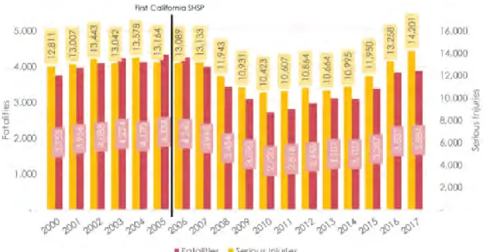
Challenge Areas for SHSP 2020-2024 Aggressive Driving
PROGRAMS AND GUIDANCE
Issue identification
Generally, the maximum federal reimbursement ratio for an HSIP project is 90%; however, there is low cost proven federal reimbursement ratio for an HSIP project is 90%; however, there are inexpensive proven security countermeasures that qualify for 100% federal funding eligibility. The timing and size of the call is determined by the program allocations, HSIP Federal Transportation Improvement is determined by the program allocations, HSIP Federal Transportation Improvement Program (FTIP) capacity, and the delivery of the existing HSIP projects.
Evaluate proposed projects based on the benefit/cost ratio. Other project selection criteria include
Caltrans HQ-Division of transportation programming sends the list of approved projects to the Metropolitan Planning Organizations (MPOs) for consideration. The MPOs amend the FTIP to
Local and Rural Road Safety Briefs: Provides a high-level overview of the development of LRSPs. The list of countermeasures includes and will only include those available in Caltrans's HSIP call for projects. The manual also contains detailed descriptions of each countermeasure, including guidance on "where to use it" and "why it works", in the appendix.
Information on the proven safety countermeasures can be found on their website.4 The list includes 20 different countermeasures that the FHWA encourages transportation agencies to consider to move toward meeting local, state, and national safety goals.
SUMMARY
MEMORANDUM
TOWN OF TRUCKEE TECHNICAL MEMO
INTRODUCTION
- SUMMARY OF FINDINGS
- Crash Patterns and Trends
- Network Screening Findings
Six percent of fatal and serious accidents occurred on snowy or icy road surfaces. Dark-lit crashes accounted for 27% of reported crashes, but only 20% of fatal and serious crashes. Of fatal and serious injury crashes, both of these movements accounted for 28% (5 crashes) of fatal and serious bicycle crashes.
When looking at fatal and serious injury crashes, these movements accounted for 57% (4 crashes) of fatal and serious injury pedestrian crashes.
TOWNWIDE CRASH PATTERNS AND TRENDS
- DATA SUMMARY 1. Crash Data
- ROADWAY CHARACTERISTIC AND LAND USE DATA
There is also a growing commercial/public service activity center (near the airport) in the southeast area around SR 267 and Brockway Road.
TOWNWIDE CRASH ANALYSIS
- ALL ROAD USERS
- Crash Severity
- Crash Location
- Crash Type
- Primary Collision Factor
- Crashes by Month
- Time of Day and Day of Week
- Weather
- Road Surface
- Lighting
- Alcohol Involved
- Crashes by Year
- Summer vs. Winter Seasons
- BICYCLE AND PEDESTRIAN CRASHES
- Movements Preceding Crash 1. Bicyclist Crashes
- Primary Collision Factor 1. Bicyclist Crashes
- Crash Location 1. Bicyclist Crashes
- Lighting
- Trend by Year
- Conclusions
- Comparison with Statewide Averages
As Figure 1 shows, data on fatal and serious injury crashes differ from the total number of reported crashes by type. Clear weather accidents accounted for 66% of all reported accidents, but accounted for 85% of fatal and serious injury accidents and 83% of other injury accidents. Accidents that occur in the dark account for 27% of all reported accidents and 20% of fatal and serious injury traffic accidents.
Daylight accidents account for 69% of total reported accidents and 76% of fatal and serious injury accidents.
NETWORK SCREENING ANALYSIS
- DATA AND NETWORK SCREENING APPROACH
- Intersection Methodology
- Roadway Segment Methodology
- NETWORK SCREENING FINDINGS
- Total Reported Crashes
- Bicycle and Pedestrian Crashes
- Summer-Month Crashes
- Winter-Month Crashes
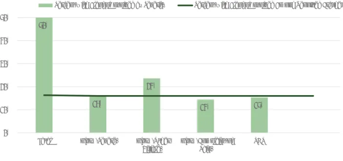
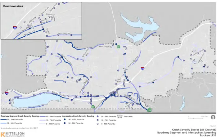
Kittelson annual crash severity score by dividing the score by the years (5) of analyzed crash data. The crash severity numbers will help the city identify priority locations for safety improvement projects. For intersection locations, crash severity scores ranged from zero (no reported crashes during the 5 years) to 80.37.
For intersection locations, crash severity scores ranged from zero (no reported crashes over the five years) to 76.09.
STRATEGIES AND COUNTERMEASURES
- ENGINEERING TREATMENTS
- Pedestrian Crossing Enhancements
- Bicycle Intersection Treatments
- Signalized Intersection Treatments
- Unsignalized Intersection Treatments
- Roadway Segment Treatments
- EDUCATION STRATEGIES
- Road Safety Education to Children
- Speed Monitoring Awareness Radar Trailer
- Conspicuity Enhancements and Education
- Vulnerable Road User Education
- High-Visibility Cell Phone and Text Messaging Media Campaign
- ENFORCEMENT STRATEGIES
- Progressive Ticketing
- Speed Enforcement in School Zones
- EMERGENCY RESPONSE STRATEGIES
- Partner with Local Hospitals or Outreach Groups
- Work with Stakeholders
- Work with the Town 911 Team
- INNOVATIVE APPROACHES
- Alerting Drivers at Risk
- Protecting the Vehicle Occupants
- Communicating with Drivers and the Environment
- Vehicle Performing as Designed
- Mobile Technology and Applications
This treatment may be better suited as a spot treatment or as a treatment package in urban areas. Considerations: These treatments may be considered if the high frequency of crashes is related to the visibility of the intersection, or if the footprint of the intersection is not clearly defined by stripes or sidewalk markings. Application: These treatments may be considered at any unsignalized intersection where the sight distance at the intersection is limited by on-street parking or other obstacles.
Considerations: These treatments may be considered when a high accident rate is associated with conflicting movements that may be affected by limited visibility of the intersection. Application: These treatments may be considered at any horizontal bend where visibility of the approaching bend is limited or providing guidance through the bend via chevron signs can provide safety benefits. Considerations: These treatments may be considered when high rates of run-off-road crashes associated with a horizontal curve are identified.

NEXT STEPS
Many of the current emerging technologies used for road safety are mobile in nature. Many of these are used to support transportation network companies (TNCs) such as Uber or Lyft in providing ride-sharing, bike-sharing, and scooter rental services, which together can have a significant impact on reducing driving collisions. There are also apps that restrict drivers from using mobile devices while driving.
Some of these are applications in themselves, while others are integrated into existing applications.
Truckee River Legacy Trail Phase 4 C0702
Northwoods Boulevard/Donner Pass Road Roundabout C1608
80/Donner Pass Road/Coldstream Road Roundabout C1712
The developer will act as a conduit in securing Affordable Housing Sustainable Communities (AHSC) grant funding in the amount of $1.3 million for the project. The developer will also fund construction costs up to and the City will reimburse the costs using AB1600 Traffic Impact Fees (at least 15% of total costs per year until reimbursement).
PROPOSED
Project goals consider traffic capacity, pedestrian/bicycle amenities, safety, aesthetics and ability to implement a "quiet zone" for the Union Pacific Railroad.
Jibboom, Bridge, and Church Streetscape Improvements C1806
A draft parking demand analysis and parking improvement feasibility study was prepared for parking improvements along Donner Pass Road adjacent to the Tahoe Donner Beach Club Marina and Donner Memorial State Park. The project includes a short-term improvement to install boulders and signage to limit on-street parking to parallel parking, as well as the design and construction of formal parallel parking and sidewalk. Parking is currently located along Donner Pass Road, adjacent to the Tahoe Donner Beach Club and Donner Memorial State Park.
The parking lot improvements would directly benefit residents of the Tahoe Donner Town Special Service Area (TSSA 1) and will be open to the general public.
Jibboom Street Sidewalk Feasibility Study and Improvement Project C1824
Emergency evacuation planning, including an evaluation of evacuation routes and estimated time to evacuate residential areas under various scenarios such as time of year and time of day.
Innovate Gateway C1917
Tahoe Donner Roadways Brushing and Chipping Project C2008